close
-
Layers w
- Weather Layers
- Pro
- Pro
- Pro
- Pro
- Pro
- Pro
- More Layers
- Pro
- Pro
- Pro
- Pro
-
Upgrade to

3D
Trail Conditions
- Unknown
- Snow Groomed
- Snow Packed
- Snow Covered
- Snow Cover Partial
- Freeze/thaw Cycle
- Icy
- Prevalent Mud
- Wet
- Variable
- Ideal
- Dry
- Very Dry
Trail Flow (Ridden Direction)
Trailforks scans users ridelogs to determine the most popular direction each trail is ridden. A good flowing trail network will have most trails flowing in a single direction according to their intension.
The colour categories are based on what percentage of riders are riding a trail in its intended direction.
The colour categories are based on what percentage of riders are riding a trail in its intended direction.
- > 96%
- > 90%
- > 80%
- > 70%
- > 50%
- < 50%
- bi-directional trail
- no data
Trail Last Ridden
Trailforks scans ridelogs to determine the last time a trail was ridden.
- < 2 days
- < 1 week
- < 2 weeks
- < 1 month
- < 6 months
- > 6 months
Trail Ridden Direction
The intended direction a trail should be ridden.
- Downhill Only
- Downhill Primary
- Both Directions
- Uphill Primary
- Uphill Only
- One Direction
Contribute Details
Colors indicate trail is missing specified detail.
- Description
- Photos
- Description & Photos
- Videos
Trail Popularity ?
Trailforks scans ridelogs to determine which trails are ridden the most in the last 9 months.
Trails are compared with nearby trails in the same city region with a possible 25 colour shades.
Think of this as a heatmap, more rides = more kinetic energy = warmer colors.
- most popular
- popular
- less popular
- not popular
ATV/ORV/OHV Filter
Max Vehicle Width
inches
US Cell Coverage
Legend

Radar Time
Activity Recordings
Trailforks uses anonymized public activity data.
?
Activity Recordings
Trailforks uses anonymized public activity data.
?
Personal Heatmap
▶
Activity Types
all
/
none
▶
Options
2
Date range
month
–
Winter Trails
Warning
A routing network for winter maps does not exist. Selecting trails using the winter trails layer has been disabled.
Missing Trails
Most Popular
Least Popular
Trails are colored based on popularity. The more popular a trail is, the more red. Less popular trails trend towards green.
Jump Magnitude Heatmap
Heatmap of where riders jump on trails. Zoom in to see individual jumps, click circles to view jump details.
BC Backroad Status
![map legend]()
Service Road Atlas is a free to use, community-driven service for viewing and creating reports on the numerous back-country service roads around B.C. and Alberta.

Slope Aspect
Direction the slope faces
Trails Deemphasized
Trails are shown in grey.
Only show trails with no bike usage.
Suggested Layers
Based on selected activity type
Save the current map location and zoom level as your default home location whenever this page is loaded.
SaveWelcome to Mountain Biking in Iron County, Utah
If you're planning a mountain bike trip to Iron County, you’re coming to one of Utah’s most diverse and fast-growing riding destinations. Centered around Cedar City, the county offers everything from smooth beginner flow trails to high-alpine descents and scenic cross-country networks — all within about an hour of town.
Much of the purpose-built trail development in the area is led by Iron Trailcraft, the local nonprofit trail association that partners with federal, state, and local land managers to design, build, and maintain sustainable singletrack.
Here’s what you should know before you visit.
1. The Riding Is Incredibly Diverse
One of Iron County’s biggest strengths is variety. Within a short drive, you can experience:
Desert Flow & Technical Singletrack
Iron Hills Trail System
The flagship system curated by Iron Trailcraft. Over 30 miles of interconnected singletrack offer:
Beginner-friendly loops
Intermediate flow trails with berms and rhythm
Advanced technical lines and optional features
Skills park and excellent trailhead amenities
This is the most developed and rider-accessible network in the county and the best place to start your visit.
Classic Red Rock Cross-Country
Thunderbird Canyons Trail System
Natural desert singletrack with scenic views and moderate technical challenge. Great for riders who prefer narrower, more traditional cross-country terrain.
Big Vertical Shuttle Riding
Blowhard Trail
A 3,000-foot advanced descent from alpine forest into desert canyon. Best ridden via shuttle and suited for experienced riders comfortable with steep, rocky terrain.
High-Elevation Summer Escape
Navajo Lake – River Rim Trail System
Cool forest riding at 8,500–9,200 feet with volcanic rock features and spectacular rim views overlooking Zion’s backcountry. Ideal in mid-summer when lower elevations are hot.
Desert Loop Riding
Three Peaks Trail System
Classic cross-country loops northwest of Cedar City with rolling terrain, granite outcrops, and varied singletrack.
2. Timing Matters
Iron County spans multiple elevations, which means you can chase good conditions almost year-round:
Spring & Fall: Ideal for desert systems like Iron Hills, Thunderbird, and Three Peaks.
Summer: Head up high (Blowhard upper sections or Navajo Lake) to escape the heat.
Winter: Lower desert trails are often rideable when dry, but avoid muddy conditions.
Trail stewardship is important here — if trails are wet, locals strongly encourage waiting until they dry to prevent damage.
3. Logistics & Trail Access
Many Iron Hills trails connect directly to Cedar City’s paved trail system — you can often ride from town.
Shuttle planning is recommended for Blowhard.
Higher elevation systems require a vehicle and seasonal access awareness (snow lingers late).
Services (bike shops, food, lodging) are concentrated in Cedar City.
4. Trail Culture & Stewardship
Mountain biking in Iron County thrives because of strong local stewardship. Iron Trailcraft organizes:
Volunteer trail workdays
Ongoing maintenance
Sustainable trail design
Expansion of beginner-to-advanced riding options
Visitors are encouraged to:
Respect multi-use trails
Yield appropriately
Avoid riding muddy trails
Pack out everything
The community takes pride in maintaining a welcoming and responsible trail culture.
5. What Type of Rider Will Enjoy Iron County?
Great for:
Riders who want variety in one trip
Intermediate riders looking to progress
Families and mixed-ability groups
Advanced riders seeking technical descents
Summer travelers looking for high-elevation options
Less ideal for:
Lift-served bike park riders (this is pedal- or shuttle-powered riding)
Riders looking exclusively for machine-built gravity parks
Final Takeaway
Mountain biking in Iron County is about range and progression. You can warm up on smooth flow trails in the morning, ride technical desert singletrack in the afternoon, and shuttle a 3,000-foot alpine descent the next day — all while based in Cedar City.
With thoughtful development led by Iron Trailcraft and strong community support, Iron County has quietly become one of Utah’s most well-rounded mountain bike destinations.
Activities Click to view
- Mountain Bike
107 trails
- E-Bike
63 trails
- Gravel Bike
9 trails
- Adaptive Bike
19 trails
- Winter Fat Bike
10 trails
- Horse
15 trails
- Hike
122 trails
- Trail Running
115 trails
- Dirtbike/Moto
13 trails
- ATV/ORV/OHV
10 trails
Region Details
- 27
- 1
- 25
- 40
- 13
- 1
Region Status
Open as of 2 daysStats
- Avg Trail Rating
- Trails (view details)
- 129
- Trails Mountain Bike
- 107
- Trails E-Bike
- 63
- Trails Gravel Bike
- 9
- Trails Adaptive Bike
- 19
- Trails Winter Fat Bike
- 10
- Trails Horse
- 15
- Trails Hike
- 122
- Trails Trail Running
- 115
- Trails Dirtbike/Moto
- 13
- Trails ATV/ORV/OHV
- 10
- Total Distance
- 190 miles
- Total Descent
- 29,933 ft
- Total Vertical
- 5,616 ft
- Highest Trailhead
- 10,660 ft
- Reports
- 2,471
- Photos
- 981
- Ridden Counter
- 36,383
Sub Regions
-
Blowhard Trail System
- 1
-
Evil Water Trail System
- 4
-
Iron Hills Trail System
- 1
- 10
- 9
- 4
- 1
-
Iron Springs Resort
- 1
- 3
- 1
-
Three Peaks Trail System
- 9
- 17
- 5
-
Thunderbird Canyons Trail System
- 1
- 10
- 3
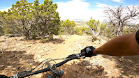
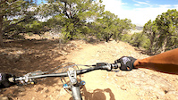
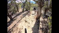
Popular Cedar City Mountain Biking Trails
• 100 ★ 4.8 • 3 miles • 456 ft • 2,102 •
As far as climbing trails go, they don't get much better. Turns are easy enough to negotiate, with a few spots that flatten out to give your legs a rest. Even a tiny downhill in the middle with a couple small drops to keep it interesting.
• 100 ★ 4.8 • 2 miles • 60 ft • 1,645 •
This is a really nice flow trail that has all kinds of fun little berms, little jumps, even a rock wall ride transition into a berm. Lots of speed and is a perfect way to stretch out the legs on your way to St. George or to hit up on...
• 100 ★ 4.8 • 3,780 ft • 10 ft • 1,136 •
Fun trail to drop off the Loop. Fast and flows at the beginning, then drops you into some sand stone transitions and even a bit of a rock drop. A rollercoaster and a couple optional rocky lines to make it interesting.
• 95 ★ 4.4 • 4 miles • 325 ft • 1,001 •
Nice easy traverse trail, is a great cross country training trail, and the beginnings of what looks like some big loops in the future. The trail mostly flows along the hillside with very little elevation gain. There are a few spots with...
• 95 ★ 4.8 • 1 mile • 353 ft • 971 •
This trail is the most common access to , but can be ridden out & back or as a part of larger loop rides in either direction. It has a nice slope with banked turns and well designed as a climbing or descent trail. Please remember to...
• 100 ★ 4.5 • 2 miles • 5 ft • 964 •
Newly built flow trail that is mostly smooth with lots of nicely bermed turns. This is a great option for riders that want to do a complete easy loop. Perfect for introducing new riders to mountain biking or taking the kids.
• 90 ★ 4.9 • 1 mile • 0 ft • 957 •
This is a Downhill only trail that has a variety of fun stuff. It is not as fast and flowing at , but has more jumps. The jumps are pretty much optional and have ways to roll, or go slowly around. The trail is very well engineered to...
• 90 ★ 4.5 • 2 miles • 550 ft • 948 •
This is a mix of fast flow and little rock jumps on the edge of the trail. It starts out with a filter feature, which is basically a little rock garden as it off of Trail, but then becomes a really smooth climb. A few minor rocky...
Cedar City Mountain Bike Routes
Liquid Hot Magma Featured
14 miles • 2,070 ft • 0 • Loop •
This is my ultimate multi-loop ride to get the best of the Iron Hills trails. It hits all the best, , and...
★ 4.5 • 8 miles • 149 ft • 4 • Shuttled •
You ready for a great downhill ride? Here you go, some of the best trails Iron Hills has to offer! You...
★ 5.0 • 6 miles • 510 ft • 1 •
Uploaded GXP file to tailforks for navigation.
★ 4.2 • 11 miles • 841 ft • 14 • Loop •
You want the full experience? Well, take the time and ride this loop. Get ready for some tough climbs and...
15 miles • 2,166 ft • 7 •
Cedar City Pretty much all the goods Relive Your Rides Climb up , You can descend here if you don't want...
Photos of Cedar City Mountain Bike
Videos of Cedar City Mountain Bike
trail: Twilight Zone
0:06 |
32 |
Apr 2, 2025
trail: Blowhard Trail
2:19 |
48 |
Feb 17, 2025
trail: YES Please
0:08 |
27 |
Jun 22, 2023

trail: The C Trail
0:24 |
21 |
May 27, 2022
trail: Black Ops
4:55 |
50 |
Apr 4, 2022
trail: Lava Flow
3:13 |
102 |
Aug 4, 2020
trail: Boulder Dash
2:16 |
148 |
Jul 23, 2020
trail: Ghost Flats
3:21 |
227 |
Nov 20, 2018
Recent Trail Reports
| status | trail | date | condition | info | user |
|---|---|---|---|---|---|
| Three Peaks | Jun 16, 2026 @ 7:55am (America/Phoenix) 2 days | Ideal | RPS1030 | ||
| Blowhard Trail | Jun 13, 2026 @ 7:49am (America/Denver) Jun 13, 2026 | Unknown | brianszimmer | ||
| Razorback Wash | Jun 8, 2026 @ 5:46pm (America/Denver) Jun 8, 2026 | Dry | FlyingJJ | ||
| The C Trail | Jun 7, 2026 @ 8:19am (America/Phoenix) Jun 7, 2026 | Dry | trswenson67 | ||
| Megawatt access | May 29, 2026 @ 4:55pm (America/Denver) May 29, 2026 | Ideal | DirtTherapy435 | ||
| Electric Avenue Access | May 29, 2026 @ 4:55pm (America/Denver) May 29, 2026 | Ideal | DirtTherapy435 | ||
| Lava Link | May 21, 2026 @ 10:10am (America/Phoenix) May 21, 2026 | Dry | chrissyprobst | ||
| Black Ops | May 21, 2026 @ 10:10am (America/Phoenix) May 21, 2026 | Dry | chrissyprobst | ||
| Elevate | May 21, 2026 @ 10:10am (America/Phoenix) May 21, 2026 | Dry | chrissyprobst | ||
| Lava Flow | May 21, 2026 @ 10:10am (America/Phoenix) May 21, 2026 | Dry | chrissyprobst |
Activity Feed
| username | action | type | title | date |
|---|---|---|---|---|
| HiddenDoors | wishlist | trail | activity #97187409 | Jun 17, 2026 @ 8:53am 21 hours |
| RPS1030 | add | report | activity #97113939 | Jun 16, 2026 @ 8:50am 2 days |
| kowski15 | wishlist | route | activity #97075675 | Jun 15, 2026 @ 5:10pm 3 days |
| Spork79 | wishlist | trail | activity #96926888 and 1 more | Jun 13, 2026 @ 4:58pm Jun 13, 2026 |
| davbla | wishlist | trail | activity #96909435 | Jun 13, 2026 @ 1:06pm Jun 13, 2026 |
Recent Comments
| username | type | title | comment | date |
|---|---|---|---|---|
| trail | isn't Lichen it uphill only?? | Jun 2, 2026 @ 1:28pm Jun 2, 2026 | ||
| report | The broken boards have been replaced however... | May 21, 2026 @ 12:11pm May 21, 2026 | ||
| trail | Nice green DH only but I saw a few features... | May 9, 2026 @ 7:33pm May 9, 2026 | ||
| trail | Basically the same as Green Hollow but maybe a... | May 9, 2026 @ 7:31pm May 9, 2026 | ||
| trail | Trail can be ridden in both directions per the... | Apr 14, 2026 @ 7:54pm Apr 14, 2026 |
Local Badges
-

10 Green Trails224 awarded -

Epic Ride 50k449 awarded -

Top 10 Trails1 awarded -

Completionist1 awarded -

Big Ride 30k1,384 awarded -
Completionist0 awarded
Bike & Skill Parks
| name | type | city | rating |
|---|---|---|---|
| Southview Skills Park | skill park | Cedar City |
Activity Type Stats
| activitytype | trails | distance | descent | descent distance | total vertical | rating | global rank | state rank | photos | reports | routes | ridelogs |
|---|---|---|---|---|---|---|---|---|---|---|---|---|
| Mountain Bike | 107 | 154 miles | 22,133 ft | 67 miles | 5,256 ft | #501 | #185 | 882 | 2,466 | 25 | 27,465 | |
| E-Bike | 63 | 100 miles | 15,758 ft | 43 miles | 5,223 ft | #1,248 | #838 | 1,897 | 2 | 1,307 | ||
| Gravel Bike | 9 | 24 miles | 5,226 ft | 13 miles | 5,256 ft | #293 | #918 | 415 | 3 | 47 | ||
| Adaptive Bike | 19 | 36 miles | 6,598 ft | 21 miles | 5,256 ft | #237 | #1,552 | 308 | ||||
| Winter Fat Bike | 10 | 8 miles | 925 ft | 4 miles | 735 ft | #198 | #985 | 800 | ||||
| Horse | 15 | 43 miles | 7,126 ft | 20 miles | 3,914 ft | #418 | #483 | 13 | 727 | 5 | ||
| Hike | 122 | 185 miles | 28,228 ft | 80 miles | 5,617 ft | #352 | #166 | 82 | 2,383 | 1 | 1,968 | |
| Trail Running | 115 | 175 miles | 26,273 ft | 77 miles | 5,617 ft | #806 | #299 | 1 | 2,380 | 1 | 1,310 | |
| Dirtbike/Moto | 13 | 31 miles | 3,422 ft | 12 miles | 4,035 ft | #629 | #216 | 719 | 1 | 9 | ||
| ATV/ORV/OHV | 10 | 31 miles | 2,556 ft | 11 miles | 4,035 ft | #436 | #141 | 696 | 10 |
Frequently Asked Questions About Cedar City
▼
What are the best places to ride in Cedar City?
Cedar City has 8 areas to explore for mountain biking. The top rated areas are:
▼
What are the highest rated mountain biking trails in Cedar City?
▼
What is the best time of the year to ride in Cedar City?
Based on ride log data, the most popular months to ride in Cedar City are:
- May (332 activities)
- July (291 activities)
- September (257 activities)
▼
Where can I park to ride in Cedar City?
There are 21 parking locations listed in Cedar City. The most popular parking spots are: View all parking and trailhead locations on the map to plan your visit.
Activities
- Cedar City Mountain Biking Trails
- Cedar City E-Biking Trails
- Cedar City Gravel Biking Trails
- Cedar City Adaptive Biking Trails
- Cedar City Winter Fat Biking Trails
- Cedar City Horseback Trails
- Cedar City Hiking Trails
- Cedar City Trail Running Trails
- Cedar City Dirtbiking Trails
- Cedar City ATVing/Offroading Trails
Trails
Points of Interest
- Race Loop Wooden path TTF
- Petrified Whales Bridge River bed Crossing TTF
- Petrified Whales Bridge TTF
- Petrified Whales Bridge #2 TTF
- Three Peaks Technical Bridge TTF
- Three peaks loop sand crossing TTF
- Three peaks loop Bridge TTF
- Three peaks loop ladder bridge TTF
- Three Peaks loop Downed Tree Bridge TTF
- Petrified Whale Wooden Bridge TTF
- Blowhard Mountain (10,577 ft)
- The Bartizan (9,629 ft)
- Cedar Breaks (9,623 ft)
- By canadaka
 Trailforks & contributors
 - Admins: jkwilliamz, UtahJohn, jpmcghee, jasonmalczyk, TASU, IronTC
- #4860 - 38,946 views
- cedar city activity log | embed map of Cedar City mountain bike trails | cedar city mountain biking points of interest
Downloading of trail gps tracks in kml & gpx formats is enabled for Cedar City.
You must login to download files.