close
-
Layers w
- Weather Layers
- Pro
- Pro
- Pro
- Pro
- Pro
- Pro
- More Layers
- Pro
- Pro
- Pro
- Pro
-
Upgrade to

3D
Trail Conditions
- Unknown
- Snow Groomed
- Snow Packed
- Snow Covered
- Snow Cover Partial
- Freeze/thaw Cycle
- Icy
- Prevalent Mud
- Wet
- Variable
- Ideal
- Dry
- Very Dry
Trail Flow (Ridden Direction)
Trailforks scans users ridelogs to determine the most popular direction each trail is ridden. A good flowing trail network will have most trails flowing in a single direction according to their intension.
The colour categories are based on what percentage of riders are riding a trail in its intended direction.
The colour categories are based on what percentage of riders are riding a trail in its intended direction.
- > 96%
- > 90%
- > 80%
- > 70%
- > 50%
- < 50%
- bi-directional trail
- no data
Trail Last Ridden
Trailforks scans ridelogs to determine the last time a trail was ridden.
- < 2 days
- < 1 week
- < 2 weeks
- < 1 month
- < 6 months
- > 6 months
Trail Ridden Direction
The intended direction a trail should be ridden.
- Downhill Only
- Downhill Primary
- Both Directions
- Uphill Primary
- Uphill Only
- One Direction
Contribute Details
Colors indicate trail is missing specified detail.
- Description
- Photos
- Description & Photos
- Videos
Trail Popularity ?
Trailforks scans ridelogs to determine which trails are ridden the most in the last 9 months.
Trails are compared with nearby trails in the same city region with a possible 25 colour shades.
Think of this as a heatmap, more rides = more kinetic energy = warmer colors.
- most popular
- popular
- less popular
- not popular
ATV/ORV/OHV Filter
Max Vehicle Width
inches
US Cell Coverage
Legend

Radar Time
Activity Recordings
Trailforks uses anonymized public activity data.
?
Activity Recordings
Trailforks uses anonymized public activity data.
?
Personal Heatmap
▶
Activity Types
all
/
none
▶
Options
2
Date range
month
–
Winter Trails
Warning
A routing network for winter maps does not exist. Selecting trails using the winter trails layer has been disabled.
Missing Trails
Most Popular
Least Popular
Trails are colored based on popularity. The more popular a trail is, the more red. Less popular trails trend towards green.
Jump Magnitude Heatmap
Heatmap of where riders jump on trails. Zoom in to see individual jumps, click circles to view jump details.
BC Backroad Status
![map legend]()
Service Road Atlas is a free to use, community-driven service for viewing and creating reports on the numerous back-country service roads around B.C. and Alberta.

Slope Aspect
Direction the slope faces
Trails Deemphasized
Trails are shown in grey.
Only show trails with no bike usage.
Suggested Layers
Based on selected activity type
Save the current map location and zoom level as your default home location whenever this page is loaded.
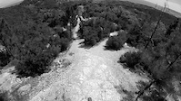
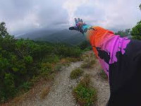
SaveCelle Ligure entrato nei borghi più belli d’Italia offre trail di tutti i tipi e difficoltà con una vista mare mozzafiato con arrivi direttamente in paese
Da segnalare il collegamento con il monte beigua che insieme formano una rete di trail ininterrotta dalla cima del monte fino alla spiaggia di oltre 15 km
Da segnalare il collegamento con il monte beigua che insieme formano una rete di trail ininterrotta dalla cima del monte fino alla spiaggia di oltre 15 km
Primary Trail Type: All-Mountain & Downhill
eBikes Allowed:
Yes
Shuttleable: YES
AKA: Celle ligure
Land Status: Community Forest
Access Info:
Piazza assunta celle ligure
Links
This region uses the Uk/Euro style trail grading system.
Activities Click to view
- Mountain Bike
99 trails
- E-Bike
86 trails
- Gravel Bike
0 trails
- Adaptive Bike
0 trails
- Winter Fat Bike
0 trails
- Hike
63 trails
- Trail Running
66 trails
Region Details
- 4
- 4
- 11
Region Status
Open as of Jun 13, 2026Stats
- Avg Trail Rating
- Trails (view details)
- 23
- Trails Mountain Bike
- 99
- Trails E-Bike
- 86
- Trails Horse
- 1
- Trails Hike
- 63
- Trails Trail Running
- 66
- Total Distance
- 9 miles
- Total Descent
- 3,631 ft
- Total Vertical
- 1,400 ft
- Highest Trailhead
- 1,455 ft
- Reports
- 659
- Photos
- 121
- Ridden Counter
- 2,418
Sub Regions
-
CelleLand
- 5
- 18
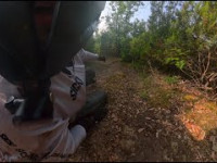
Popular Celle Ligure Mountain Biking Trails
• 100 ★ 5.0 • 4,400 ft • 368 ft • 255 •
Sentiero promiscuo da percorrere in bici preferibilmente in salita
• 100 ★ 4.9 • 2 miles • 75 ft • 158 •
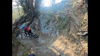
trail tecnico pieno di salti drop rock naturale dalla cima e durante il tracciato viste mozzafiato senza dimenticare il SALTO DEL LEONE che rimane in cima e da la sensazione di cadere in mare. un trail tecnico completo a CELLE LIGURE la...
• 70 ★ 4.3 • 1,148 ft • 48 ft • 90 •
Popular green difficulty singletrack. This mountain bike primary trail can be used both directions and has a moderate overall physical rating with a 48 ft green climb. On average it takes 1 minutes to complete this trail.
• 95 ★ 5.0 • 643 ft • 0 ft • 83 •
, nuova variante che evita il pezzo difficile della seconda parte del leone, sentiero adatto a tutti.
• 60 ★ 4.0 • 1,847 ft • 97 ft • 67 •
Moderately popular blue difficulty singletrack. This mountain bike primary trail can be used uphill primary and has a hard overall physical rating with a 97 ft blue climb. On average it takes 4 minutes to complete this trail.
• 65 ★ 3.8 • 3,061 ft • 6 ft • 56 •
Moderately popular blue difficulty singletrack. This mountain bike primary trail can be used downhill primary and has a moderate overall physical rating. On average it takes 5 minutes to complete this trail.
• 75 ★ 3.0 • 1,519 ft • 0 ft • 51 •
Popular blue difficulty singletrack. This mountain bike primary trail can be used downhill primary. On average it takes 2 minutes to complete this trail.
Celle Ligure Mountain Bike Routes
Photos of Celle Ligure Mountain Bike
Videos of Celle Ligure Mountain Bike
trail: Terrabianca DH
0:58 |
|
May 13, 2023
trail: Chupacabra
114 |
Jun 8, 2025 , Celle Ligure
trail: Rock crow
73 |
Jun 8, 2025 , Celle Ligure
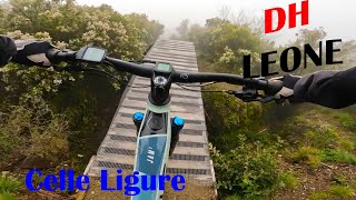
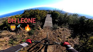
trail: DH-Leone
8:19 |
260 |
Apr 6, 2024 , Celle Ligure
trail: DH-Leone
4:22 |
349 |
Feb 24, 2024 , Celle Ligure
trail: Toboga di Gameragna
3:38 |
147 |
Jun 26, 2023 , Celle Ligure
trail: Teglia dh
4:32 |
215 |
Jun 26, 2023 , Celle Ligure
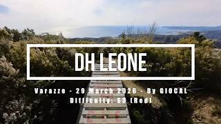
trail: DH-Leone
15:13 |
15 |
Apr 29, 2026 , Celle Ligure
Current Trail Warnings
| status | trail | date | condition | user | info |
|---|---|---|---|---|---|
| Terrabianca DH | May 24, 2026 @ 8:08am (Europe/Rome) May 23, 2026 | Variable | ecox | E-Bike Pessimo |
Recent Trail Reports
| status | trail | date | condition | info | user |
|---|---|---|---|---|---|
| Terrabianca-Brasi | Jun 14, 2026 @ 7:59am (Europe/Rome) Jun 13, 2026 | Ideal | Gabrigoride | ||
| 2 Quadrati | Jun 13, 2026 @ 7:49am (Europe/Monaco) Jun 12, 2026 | Ideal | Marcors125 | ||
| Bric dei Croi | Jun 6, 2026 @ 7:26am (Europe/Monaco) Jun 5, 2026 | Ideal | Marcors125 | ||
| Bric croi uphill | Jun 6, 2026 @ 7:26am (Europe/Monaco) Jun 5, 2026 | Ideal | Marcors125 | ||
| dh leone Easy line | Jun 6, 2026 @ 7:26am (Europe/Monaco) Jun 5, 2026 | Ideal | Marcors125 | ||
| Crestello | Jun 6, 2026 @ 7:26am (Europe/Monaco) Jun 5, 2026 | Ideal | Marcors125 | ||
| Gianni Cassi UpHill | Jun 6, 2026 @ 7:26am (Europe/Monaco) Jun 5, 2026 | Ideal | Marcors125 | ||
| Short DH to Ferrari | Jun 6, 2026 @ 7:26am (Europe/Monaco) Jun 5, 2026 | Ideal | Marcors125 | ||
| Not A Race Extension | May 30, 2026 @ 8:20am (Europe/Monaco) May 29, 2026 | Ideal | stefanosantoni | ||
| Variante Motocross/Brasi | May 30, 2026 @ 8:20am (Europe/Monaco) May 29, 2026 | Ideal | stefanosantoni |
Activity Feed
| username | action | type | title | date |
|---|---|---|---|---|
| MatteopHMsk8 | wishlist | trail | activity #97432816 | Jun 20, 2026 @ 2:20pm 23 hours |
| Gabrigoride | add | report | activity #96953442 | Jun 14, 2026 @ 4:12am Jun 14, 2026 |
| Marcors125 | add | report | activity #96881760 | Jun 13, 2026 @ 8:38am Jun 13, 2026 |
| Marcors125 | add | report | activity #96352692 and 6 more | Jun 6, 2026 @ 3:30am Jun 6, 2026 |
| Trailimmi | wishlist | trail | activity #95873058 | May 30, 2026 @ 11:34am May 30, 2026 |
Recent Comments
| username | type | title | comment | date |
|---|---|---|---|---|
| trail | The trail has some very steep sections which... | Apr 29, 2026 @ 11:16am Apr 29, 2026 | ||
| trail | Tornati dopo un po' di tempo A nostro avviso... | Apr 13, 2026 @ 9:52am Apr 13, 2026 | ||
| report | Occhio ai due doppi prima del river gap (che... | Apr 4, 2026 @ 3:57am Apr 4, 2026 | ||
| report | Stanno finendo di fare la segnaletica nuova | Mar 29, 2026 @ 9:36am Mar 29, 2026 | ||
| trail | Una variante niente di che , a parte lo... | Feb 1, 2026 @ 2:03pm Feb 1, 2026 |
Local Badges
-

Epic Mountain Bike Climb 2k16 awarded -

Climbing 10k Badge3 awarded -

Mountain Biking 100k Badge0 awarded -

Epic Ride Descent 2k16 awarded -

Descent 10k Badge4 awarded -

Descent 100k Badge0 awarded
Activity Type Stats
| activitytype | trails | distance | descent | descent distance | total vertical | rating | global rank | state rank | photos | reports | routes | ridelogs |
|---|---|---|---|---|---|---|---|---|---|---|---|---|
| Mountain Bike | 99 | 9 miles | 3,632 ft | 5 miles | 1,401 ft | #2,928 | #141 | 86 | 660 | 1 | 853 | |
| E-Bike | 86 | 7 miles | 2,569 ft | 4 miles | 1,401 ft | #2,089 | #198 | 36 | 649 | 151 | ||
| Horse | 1 | 13 | ||||||||||
| Hike | 63 | 6 miles | 1,801 ft | 3 miles | 1,247 ft | #7,233 | #404 | 580 | 41 | |||
| Trail Running | 66 | 7 miles | 2,067 ft | 3 miles | 1,253 ft | #6,499 | #365 | 580 | 16 |
Frequently Asked Questions About Celle Ligure
▼
What are the best places to ride in Celle Ligure?
Celle Ligure has 1 areas to explore for mountain biking. The top rated areas are:
▼
What are the highest rated mountain biking trails in Celle Ligure?
The highest rated mountain biking trails in Celle Ligure are:
- 2 Quadrati (4.6/5)
- DH-Leone (4.6/5)
- HARD-LINE (4.4/5)
- Chupacabra (4.3/5)
- windmill (4.3/5)
▼
What is the best time of the year to ride in Celle Ligure?
Based on ride log data, the most popular months to ride in Celle Ligure are:
- July (2 activities)
- October (1 activities)
- January (1 activities)
▼
Where can I park to ride in Celle Ligure?
There are 1 parking locations listed in Celle Ligure. The most popular parking spots are:
Activities
Trails
Points of Interest
- By paolocanavese
 & contributors
 - Admins: denitopia
- #20155 - 5,678 views
- celle ligure activity log | embed map of Celle Ligure mountain bike trails | celle ligure mountain biking points of interest
Downloading of trail gps tracks in kml & gpx formats is enabled for Celle Ligure.
You must login to download files.