close
-
Layers w
- Weather Layers
- Pro
- Pro
- Pro
- Pro
- Pro
- Pro
- More Layers
- Pro
- Pro
- Pro
- Pro
-
Upgrade to

3D
Trail Conditions
- Unknown
- Snow Groomed
- Snow Packed
- Snow Covered
- Snow Cover Partial
- Freeze/thaw Cycle
- Icy
- Prevalent Mud
- Wet
- Variable
- Ideal
- Dry
- Very Dry
Trail Flow (Ridden Direction)
Trailforks scans users ridelogs to determine the most popular direction each trail is ridden. A good flowing trail network will have most trails flowing in a single direction according to their intension.
The colour categories are based on what percentage of riders are riding a trail in its intended direction.
The colour categories are based on what percentage of riders are riding a trail in its intended direction.
- > 96%
- > 90%
- > 80%
- > 70%
- > 50%
- < 50%
- bi-directional trail
- no data
Trail Last Ridden
Trailforks scans ridelogs to determine the last time a trail was ridden.
- < 2 days
- < 1 week
- < 2 weeks
- < 1 month
- < 6 months
- > 6 months
Trail Ridden Direction
The intended direction a trail should be ridden.
- Downhill Only
- Downhill Primary
- Both Directions
- Uphill Primary
- Uphill Only
- One Direction
Contribute Details
Colors indicate trail is missing specified detail.
- Description
- Photos
- Description & Photos
- Videos
Trail Popularity ?
Trailforks scans ridelogs to determine which trails are ridden the most in the last 9 months.
Trails are compared with nearby trails in the same city region with a possible 25 colour shades.
Think of this as a heatmap, more rides = more kinetic energy = warmer colors.
- most popular
- popular
- less popular
- not popular
ATV/ORV/OHV Filter
Max Vehicle Width
inches
US Cell Coverage
Legend

Radar Time
Activity Recordings
Trailforks uses anonymized public activity data.
?
Activity Recordings
Trailforks uses anonymized public activity data.
?
Personal Heatmap
▶
Activity Types
all
/
none
▶
Options
2
Date range
month
–
Winter Trails
Warning
A routing network for winter maps does not exist. Selecting trails using the winter trails layer has been disabled.
Missing Trails
Most Popular
Least Popular
Trails are colored based on popularity. The more popular a trail is, the more red. Less popular trails trend towards green.
Jump Magnitude Heatmap
Heatmap of where riders jump on trails. Zoom in to see individual jumps, click circles to view jump details.
BC Backroad Status
![map legend]()
Service Road Atlas is a free to use, community-driven service for viewing and creating reports on the numerous back-country service roads around B.C. and Alberta.

Slope Aspect
Direction the slope faces
Trails Deemphasized
Trails are shown in grey.
Only show trails with no bike usage.
Suggested Layers
Based on selected activity type
Save the current map location and zoom level as your default home location whenever this page is loaded.
SaveFast, flowing singletrack through the urban forest, smack in the middle of Des Moines.
source: Central Iowa Trails Association
Primary Trail Type: Cross-Country
 google parking directions
Links
Activities Click to view
- Mountain Bike
25 trails
- E-Bike
5 trails
- Hike
28 trails
- Trail Running
28 trails
Region Details
- 2
- 8
- 9
Region Status
Caution as of Dec 1, 2025Stats
- Avg Trail Rating
- Trails (view details)
- 19
- Trails Mountain Bike
- 28
- Trails E-Bike
- 5
- Trails Hike
- 28
- Trails Trail Running
- 28
- Total Distance
- 19 miles
- Total Descent
- 964 ft
- Total Vertical
- 156 ft
- Highest Trailhead
- 951 ft
- Reports
- 975
- Photos
- 17
- Ridden Counter
- 3,430
Popular Center Trails Mountain Biking Trails
• 95 ★ 5.0 • 545 ft • 0 ft • 210 •
Popular blue difficulty singletrack. This mountain bike primary trail can be used both directions. On average it takes minutes to complete this trail.
• 90 ★ 5.0 • 899 ft • 16 ft • 199 •
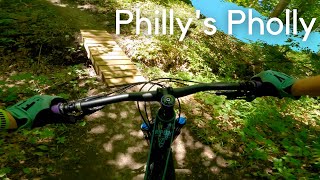
Trail is marked blue and is continuation of the rest of Hillside, Fingers, Philly’s Pholly.
• 90 ★ 5.0 • 2,280 ft • 5 ft • 199 •
Popular blue difficulty singletrack. This mountain bike primary trail can be used both directions. On average it takes 3 minutes to complete this trail.
• 90 ★ 5.0 • 4,531 ft • 59 ft • 195 •
Popular blue difficulty singletrack. This mountain bike primary trail can be used both directions. On average it takes 5 minutes to complete this trail.
• 85 ★ 5.0 • 4,905 ft • 93 ft • 183 •
Popular blue difficulty singletrack. This mountain bike primary trail can be used both directions. On average it takes 6 minutes to complete this trail.
• 80 ★ 5.0 • 2,021 ft • 71 ft • 183 •
Popular blue difficulty singletrack. This mountain bike primary trail can be used both directions. On average it takes 3 minutes to complete this trail.
• 85 ★ 0.0 • 2,608 ft • 11 ft • 180 •
Popular blue difficulty singletrack. This mountain bike primary trail can be used both directions. On average it takes 3 minutes to complete this trail.
• 85 ★ 5.0 • 2,080 ft • 14 ft • 169 •
Popular blue difficulty singletrack. This mountain bike primary trail can be used both directions. On average it takes 2 minutes to complete this trail.
Photos of Center Trails Mountain Bike
Videos of Center Trails Mountain Bike

12:42 |
756 |
Jul 18, 2021
3:14 |
217 |
Jul 18, 2021
4:45 |
294 |
Jul 18, 2021
5:07 |
195 |
Jul 18, 2021
7:56 |
254 |
Aug 25, 2020
Recent Trail Reports
| status | trail | date | condition | info | user |
|---|---|---|---|---|---|
| Hillside Trail | Dec 1, 2025 @ 9:52pm (America/Chicago) Dec 1, 2025 | Snow Covered | stehjd | ||
| Poolside | Dec 1, 2025 @ 9:52pm (America/Chicago) Dec 1, 2025 | Snow Covered | stehjd | ||
| Rollercoaster | Dec 1, 2025 @ 9:51pm (America/Chicago) Dec 1, 2025 | Snow Packed | stehjd | ||
| Denman Woods Trail | Nov 23, 2025 @ 7:54pm (America/Chicago) Nov 23, 2025 | Unknown | jstegeman | ||
| J11 | Nov 3, 2025 @ 4:09pm (America/Chicago) Nov 3, 2025 | Ideal | jstegeman | ||
| Dirty Connector Trail | Oct 5, 2025 @ 10:39am (America/Chicago) Oct 5, 2025 | Unknown | UniversityVacuumQaUb19 | ||
| Hillside Access | Oct 3, 2025 @ 5:32pm (America/Chicago) Oct 3, 2025 | Very Dry | dmccloney CITA | ||
| Hillside | Oct 3, 2025 @ 5:32pm (America/Chicago) Oct 3, 2025 | Very Dry | dmccloney CITA | ||
| Hillside Trail | Oct 3, 2025 @ 5:32pm (America/Chicago) Oct 3, 2025 | Very Dry | dmccloney CITA | ||
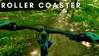
| Rollercoaster Extension | Aug 18, 2025 @ 11:28pm Aug 18, 2025 | Ideal | 7Imguf |
Activity Feed
| username | action | type | title | date |
|---|---|---|---|---|
| Rdwoten | wishlist | region | activity #94663658 | May 13, 2026 @ 6:50pm May 13, 2026 |
| stehjd | add | report | activity #85040511 and 2 more | Dec 1, 2025 @ 7:51pm Dec 1, 2025 |
| stehjd | ridden | trail | activity #85040481 | Dec 1, 2025 @ 7:50pm Dec 1, 2025 |
| jstegeman | add | report | activity #84639045 | Nov 23, 2025 @ 5:54pm Nov 23, 2025 |
| jstegeman | add | report | activity #83536192 and 1 more | Nov 3, 2025 @ 4:29pm Nov 3, 2025 |
Recent Comments
| username | type | title | comment | date |
|---|---|---|---|---|
| report | Trail closed due to recent flooding | Aug 13, 2025 @ 6:58pm Aug 13, 2025 | ||
| trail | Midsummer vegetation including stinging nettle... | Jul 17, 2022 @ 7:14pm Jul 17, 2022 | ||
| trail | Fencing has been added on paved path side that... | Nov 18, 2021 @ 7:33am Nov 18, 2021 | ||
| trail | This trail is permanently CLOSED and is... | Oct 18, 2021 @ 9:36am Oct 18, 2021 | ||
| trail | This is not signed as Hillside on the signs in... | Sep 15, 2021 @ 10:03am Sep 15, 2021 |
Nearby Areas
| name | distance | ||||
|---|---|---|---|---|---|
| Southwoods Park | 1 | 2 | 3.3 km | ||
| Sycamore South | 4 | 1 | 5.1 km | ||
| Ewing Park | 7 | 4 | 2 | 6 km | |
| Sycamore | 7 | 9 | 6.8 km | ||
| Easter Lake Park | 6.9 km |
Local Badges
-

Completionist8 awarded
Local Mountain Biking Directory
-
Central Iowa Trails Association
![Central Iowa Trails Association]()
-
Des Moines Bike CollectiveBike Shop
![Des Moines Bike Collective]()
-
Beaverdale BicyclesBike Shop
-
Barr Bicycle & FitnessBike Shop
-
Ichi BikeBike Shop
-
Modern BikeBike Shop
Activity Type Stats
| activitytype | trails | distance | descent | descent distance | total vertical | rating | global rank | state rank | photos | reports | routes | ridelogs |
|---|---|---|---|---|---|---|---|---|---|---|---|---|
| Mountain Bike | 25 | 19 miles | 965 ft | 4 miles | 154 ft | #1,973 | #664 | 16 | 997 | 6,836 | ||
| E-Bike | 5 | 2,487 ft | 3 ft | 673 ft | 7 ft | #10,089 | #3,524 | 909 | 164 | |||
| Hike | 28 | 19 miles | 965 ft | 4 miles | 154 ft | #8,929 | #3,369 | 997 | 105 | |||
| Trail Running | 28 | 19 miles | 965 ft | 4 miles | 154 ft | #8,028 | #2,767 | 1 | 997 | 140 |
Frequently Asked Questions About Center Trails
▼
What are the highest rated mountain biking trails in Center Trails?
The highest rated mountain biking trails in Center Trails are:
- Denman Woods Trail (4.3/5)
- Hillside Access (4.2/5)
- Rollercoaster Extension (4.2/5)
- Rollercoaster (4.2/5)
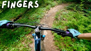
- Fingers (4.2/5)
▼
What is the best time of the year to ride in Center Trails?
Based on ride log data, the most popular months to ride in Center Trails are:
- July (30 activities)
- September (25 activities)
- August (22 activities)
▼
Where can I park to ride in Center Trails?
There are 1 parking locations listed in Center Trails. The most popular parking spots are:
▼
What is the longest trail in Center Trails?
The longest trail in Center Trails is Clive Greenbelt Trail at 5.4 miles. View all trails sorted by distance.
Activities
- By brenthillier
 NSMBA TRAILFORKS & contributors
 - Admins: CITA
- #16905 - 5,586 views
- center trails activity log | embed map of Center Trails mountain bike trails | center trails mountain biking points of interest
Downloading of trail gps tracks in kml & gpx formats is enabled for Center Trails.
You must login to download files.