close
-
Layers w
- Weather Layers
- Pro
- Pro
- Pro
- Pro
- Pro
- Pro
- More Layers
- Pro
- Pro
- Pro
- Pro
-
Upgrade to

3D
Trail Conditions
- Unknown
- Snow Groomed
- Snow Packed
- Snow Covered
- Snow Cover Partial
- Freeze/thaw Cycle
- Icy
- Prevalent Mud
- Wet
- Variable
- Ideal
- Dry
- Very Dry
Trail Flow (Ridden Direction)
Trailforks scans users ridelogs to determine the most popular direction each trail is ridden. A good flowing trail network will have most trails flowing in a single direction according to their intension.
The colour categories are based on what percentage of riders are riding a trail in its intended direction.
The colour categories are based on what percentage of riders are riding a trail in its intended direction.
- > 96%
- > 90%
- > 80%
- > 70%
- > 50%
- < 50%
- bi-directional trail
- no data
Trail Last Ridden
Trailforks scans ridelogs to determine the last time a trail was ridden.
- < 2 days
- < 1 week
- < 2 weeks
- < 1 month
- < 6 months
- > 6 months
Trail Ridden Direction
The intended direction a trail should be ridden.
- Downhill Only
- Downhill Primary
- Both Directions
- Uphill Primary
- Uphill Only
- One Direction
Contribute Details
Colors indicate trail is missing specified detail.
- Description
- Photos
- Description & Photos
- Videos
Trail Popularity ?
Trailforks scans ridelogs to determine which trails are ridden the most in the last 9 months.
Trails are compared with nearby trails in the same city region with a possible 25 colour shades.
Think of this as a heatmap, more rides = more kinetic energy = warmer colors.
- most popular
- popular
- less popular
- not popular
ATV/ORV/OHV Filter
Max Vehicle Width
inches
US Cell Coverage
Legend

Radar Time
Activity Recordings
Trailforks uses anonymized public activity data.
?
Activity Recordings
Trailforks uses anonymized public activity data.
?
Personal Heatmap
▶
Activity Types
all
/
none
▶
Options
2
Date range
month
–
Winter Trails
Warning
A routing network for winter maps does not exist. Selecting trails using the winter trails layer has been disabled.
Missing Trails
Most Popular
Least Popular
Trails are colored based on popularity. The more popular a trail is, the more red. Less popular trails trend towards green.
Jump Magnitude Heatmap
Heatmap of where riders jump on trails. Zoom in to see individual jumps, click circles to view jump details.
BC Backroad Status
![map legend]()
Service Road Atlas is a free to use, community-driven service for viewing and creating reports on the numerous back-country service roads around B.C. and Alberta.

Slope Aspect
Direction the slope faces
Trails Deemphasized
Trails are shown in grey.
Only show trails with no bike usage.
Suggested Layers
Based on selected activity type
Save the current map location and zoom level as your default home location whenever this page is loaded.
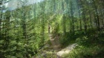
SaveThis trail system consists of over 110 miles of unique mostly sub alpine singletrack all currently open to mountain bikes. The Kettle Crest Trail itself stretches for an impressive 40 miles reaching from the Colville Indian Reservation to the North nearly stretching into Canada. Elevation of the trail varies from the bottom of the spur trails ranging mostly 3 to 4 thousand feet of elevation. Kettle Crest itself runs at around 5 to 6 thousand feet in elevation, as the trail constantly climbs up and down various peaks and saddles.
source: Evergreen Mountain Bike Alliance
Primary Trail Type: Cross-Country
eBikes Allowed:
No
AKA: Sherman Pass
Land Status: National Forest
 google parking directions
 Access Info:
Kettle Crest is in the Colville National Forest, in the North East corner of Washington State. The most popular access to the trail is on Sherman Pass on Highway 20, in between the towns of Republic and Kettle Falls. Kettle Crest Trail meanders North/South atop the Kettle Range and the trail system also composes of many trails that spur off the mountain range at assorted points across. All of these spur trails eventually wind up ending on these roads. These roads are mostly forest service fire roads, some easily drivable, some get pretty primitive and require AWD or 4WD.
Activities Click to view
- Mountain Bike
21 trails
- Hike
21 trails
- Trail Running
21 trails
Region Details
- 3
- 2
- 15
- 1
Region Status
Open as of Sep 1, 2025Stats
- Avg Trail Rating
- Trails (view details)
- 21
- Trails Mountain Bike
- 21
- Trails E-Bike
- 1
- Trails Horse
- 2
- Trails Hike
- 21
- Trails Trail Running
- 21
- Trails Dirtbike/Moto
- 1
- Trails ATV/ORV/OHV
- 1
- Total Distance
- 55 miles
- Total Descent
- 11,765 ft
- Total Vertical
- 3,249 ft
- Highest Trailhead
- 7,138 ft
- Reports
- 147
- Photos
- 108
- Ridden Counter
- 979
Popular Central Kettle Crest Mountain Biking Trails
• 100 ★ 4.9 • 2 miles • 649 ft • 147 •
Kettle Crest trail north from Highway 20 to Deer Creek summit.
• 100 ★ 4.3 • 3 miles • 154 ft • 146 •
Like most in this area, a loop that involves a portion of the Kettle Crest trail, and then (usually) a descent down the trail. Some do as an out and back, or as a climb. Most do it as a DH finish to a loop.
• 100 ★ 4.7 • 4 miles • 1,113 ft • 132 •
Popular blue difficulty singletrack. This mountain bike primary trail. On average it takes 1 hour15 minutes to complete this trail.
• 95 ★ 3.8 • 4 miles • 1,498 ft • 80 •
This steady climb from the intersection of the trail / Campground to the Kettle Crest travels through forest, mountain streams, and meadows. This trail connects with Kettle Crest (North) trail and the Sherman Pass Summit trailhead parking.
• 100 ★ 4.0 • 1 mile • 706 ft • 35 •
This is a spur trail off of the Kettle Crest (North) trail. It is a multi-use loop but the best choice for biking is to turn left about a half mile up instead of continuing and doing the hiking trail loop.
• 75 ★ 3.0 • 2 miles • 600 ft • 35 •
The historic old stage road is now a trail. This access the Kettle Crest trail at the summit of this road.
• 75 ★ 1.4 • 1,502 ft • 116 ft • 33 •
Popular blue difficulty singletrack. This mountain bike primary trail can be used both directions. On average it takes 3 minutes to complete this trail.
• 5 ★ 0.0 • 252 ft • 66 ft • 32 •
Less popular blue difficulty singletrack. This mountain bike primary trail can be used both directions. On average it takes 1 minutes to complete this trail.
Photos of Central Kettle Crest Mountain Bike
Videos of Central Kettle Crest Mountain Bike
trail: Jungle Hill
5:32 |
655 |
Aug 8, 2010
trail: Parking Lot Connector
0:57 |
742 |
Jun 19, 2010
Recent Trail Reports
| status | trail | date | condition | info | user |
|---|---|---|---|---|---|
| Kettle Crest Trail - Columbia Mountain to Jungle Hill | Aug 23, 2025 @ 4:31pm Aug 23, 2025 | Dry | bizango-x | ||
| Kettle Crest Trail - Sherman Pass to Columbia Mountain | Aug 23, 2025 @ 4:30pm Aug 23, 2025 | Dry | bizango-x | ||
| Sherman Pass | Aug 23, 2025 @ 4:30pm Aug 23, 2025 | Dry | bizango-x | ||
| Jungle Hill | Aug 23, 2025 @ 4:29pm Aug 23, 2025 | Dry | bizango-x | ||
| Columbia Mountain | Jul 16, 2025 @ 2:53pm Jul 16, 2025 | Ideal | HTFL | ||
| Wapaloosie | Jun 30, 2025 @ 9:42pm Jun 30, 2025 | Variable | ZimmerErich | ||
| Kettle Crest Trail - Jungle Hill to Old Stage | Jun 30, 2025 @ 9:38pm Jun 30, 2025 | Ideal | ZimmerErich | ||
| Midnight Ridge | Jun 29, 2025 @ 7:50pm Jun 29, 2025 | Unknown | curlewtom | ||
| Old Stage (West Side) | Jun 29, 2025 @ 7:50pm Jun 29, 2025 | Unknown | curlewtom | ||
| Columbia Mountain Loop | Jun 17, 2025 @ 7:51am Jun 17, 2025 | Dry | curlewtom |
Activity Feed
| username | action | type | title | date |
|---|---|---|---|---|
| Pmax612 | ridden | trail | activity #96869723 | Jun 13, 2026 @ 6:29am Jun 13, 2026 |
| Hunterhulsing | wishlist | trail | activity #95525134 | May 25, 2026 @ 2:45pm May 25, 2026 |
| jm3womack | wishlist | region | activity #93214076 | Apr 23, 2026 @ 8:05am Apr 23, 2026 |
| edridesbikes | wishlist | region | activity #92477568 | Apr 12, 2026 @ 8:47am Apr 12, 2026 |
| JakeArch | wishlist | trail | activity #91394351 | Mar 27, 2026 @ 1:52pm Mar 27, 2026 |
Recent Comments
| username | type | title | comment | date |
|---|---|---|---|---|
| trail | Plenty pitchy… don’t let the green rating... | Sep 29, 2024 @ 9:22pm Sep 29, 2024 | ||
| trail | Instead of the nice packed out single track it... | Aug 10, 2024 @ 2:07pm Aug 10, 2024 | ||
| trail | 8/10/24 - Cows have destroyed the trail. So... | Aug 10, 2024 @ 2:04pm Aug 10, 2024 | ||
| trail | I liked this little loop- doesn’t appear to... | Sep 6, 2022 @ 3:04pm Sep 6, 2022 | ||
| trail | Rode Sherman to Taylor a few days ago. North... | Aug 25, 2022 @ 12:06pm Aug 25, 2022 |
Nearby Areas
| name | distance | ||||
|---|---|---|---|---|---|
| North Kettle Crest | 1 | 11 | 8.9 km | ||
| South Kettle Crest | 1 | 8 | 2 | 9.1 km | |
| Ferry County Rail Trail | 2 | 10.2 km | |||
| Hesse Park - Mountain Bike Skills Park | 3 | 11.9 km | |||
| Swan Lake | 2 | 20.7 km |
Local Badges
-

Completionist0 awarded
Activity Type Stats
| activitytype | trails | distance | descent | descent distance | total vertical | rating | global rank | state rank | photos | reports | routes | ridelogs |
|---|---|---|---|---|---|---|---|---|---|---|---|---|
| Mountain Bike | 21 | 55 miles | 11,765 ft | 22 miles | 3,248 ft | #4,248 | #1,497 | 108 | 147 | 76 | ||
| E-Bike | 1 | 7 miles | 341 ft | 2 miles | 1,322 ft | 63 | 11 | |||||
| Horse | 2 | 4 miles | 1,978 ft | 3 miles | 1,870 ft | 27 | ||||||
| Hike | 21 | 55 miles | 11,765 ft | 22 miles | 3,248 ft | #4,660 | #1,670 | 147 | 16 | |||
| Trail Running | 21 | 55 miles | 11,765 ft | 22 miles | 3,248 ft | #3,782 | #1,050 | 147 | 1 | |||
| Dirtbike/Moto | 1 | 7 miles | 341 ft | 2 miles | 1,322 ft | 22 | ||||||
| ATV/ORV/OHV | 1 | 7 miles | 341 ft | 2 miles | 1,322 ft | 22 |
Frequently Asked Questions About Central Kettle Crest
▼
What are the highest rated mountain biking trails in Central Kettle Crest?
The highest rated mountain biking trails in Central Kettle Crest are:
- Kettle Crest Trail - Sherman Pass to Columbia Mountain (4.5/5)
- Jungle Hill (4.1/5)
- Kettle Crest Trail - Columbia Mountain to Jungle Hill (4.1/5)
- Midnight Ridge (4.1/5)
- Columbia Mountain (4/5)
▼
Where can I park to ride in Central Kettle Crest?
There are 5 parking locations listed in Central Kettle Crest. The most popular parking spots are: View all parking and trailhead locations on the map to plan your visit.
▼
What is the longest trail in Central Kettle Crest?
The longest trail in Central Kettle Crest is Kettle Crest Trail - Jungle Hill to Old Stage at 6.5 miles. View all trails sorted by distance.
▼
What are the best & highest rated hiking trails in Central Kettle Crest?
The best hiking trails in Central Kettle Crest are: View all hiking trails sorted by popularity score.
Activities
Trails
- By Bricklin69
 & contributors
 - Admins: EMBA-EC, EMBA EC Rep
- #5960 - 9,287 views
- central kettle crest activity log | embed map of Central Kettle Crest mountain bike trails | central kettle crest mountain biking points of interest
Downloading of trail gps tracks in kml & gpx formats is enabled for Central Kettle Crest.
You must login to download files.