close
-
Layers w
- Weather Layers
- Pro
- Pro
- Pro
- Pro
- Pro
- Pro
- More Layers
- Pro
- Pro
- Pro
- Pro
-
Upgrade to

3D
Trail Conditions
- Unknown
- Snow Groomed
- Snow Packed
- Snow Covered
- Snow Cover Partial
- Freeze/thaw Cycle
- Icy
- Prevalent Mud
- Wet
- Variable
- Ideal
- Dry
- Very Dry
Trail Flow (Ridden Direction)
Trailforks scans users ridelogs to determine the most popular direction each trail is ridden. A good flowing trail network will have most trails flowing in a single direction according to their intension.
The colour categories are based on what percentage of riders are riding a trail in its intended direction.
The colour categories are based on what percentage of riders are riding a trail in its intended direction.
- > 96%
- > 90%
- > 80%
- > 70%
- > 50%
- < 50%
- bi-directional trail
- no data
Trail Last Ridden
Trailforks scans ridelogs to determine the last time a trail was ridden.
- < 2 days
- < 1 week
- < 2 weeks
- < 1 month
- < 6 months
- > 6 months
Trail Ridden Direction
The intended direction a trail should be ridden.
- Downhill Only
- Downhill Primary
- Both Directions
- Uphill Primary
- Uphill Only
- One Direction
Contribute Details
Colors indicate trail is missing specified detail.
- Description
- Photos
- Description & Photos
- Videos
Trail Popularity ?
Trailforks scans ridelogs to determine which trails are ridden the most in the last 9 months.
Trails are compared with nearby trails in the same city region with a possible 25 colour shades.
Think of this as a heatmap, more rides = more kinetic energy = warmer colors.
- most popular
- popular
- less popular
- not popular
ATV/ORV/OHV Filter
Max Vehicle Width
inches
US Cell Coverage
Legend

Radar Time
Activity Recordings
Trailforks uses anonymized public activity data.
?
Activity Recordings
Trailforks uses anonymized public activity data.
?
Personal Heatmap
▶
Activity Types
all
/
none
▶
Options
2
Date range
month
–
Winter Trails
Warning
A routing network for winter maps does not exist. Selecting trails using the winter trails layer has been disabled.
Missing Trails
Most Popular
Least Popular
Trails are colored based on popularity. The more popular a trail is, the more red. Less popular trails trend towards green.
Jump Magnitude Heatmap
Heatmap of where riders jump on trails. Zoom in to see individual jumps, click circles to view jump details.
BC Backroad Status
![map legend]()
Service Road Atlas is a free to use, community-driven service for viewing and creating reports on the numerous back-country service roads around B.C. and Alberta.

Slope Aspect
Direction the slope faces
Trails Deemphasized
Trails are shown in grey.
Only show trails with no bike usage.
Suggested Layers
Based on selected activity type
Save the current map location and zoom level as your default home location whenever this page is loaded.
SaveCentre Vorlage est une destination plein air quatre saisons à Wakefield, au cœur de l'Outaouais. Que vous soyez à la recherche d'une descente technique ou d'une montée en skimo à l'aube, c'est votre montagne.
Été : Explorez un réseau de sentiers de vélo de montagne desservis par une remontée mécanique, avec location de vélos et station de réparation sur place. Décompressez sur le terrain de volleyball de plage, puis passez au Bistro Le Hub — ouvert dès que la remontée tourne.
Horaire de la remontée — été 2026 :
Sam–dim 10 h–18 h · 23 mai – 22 juin
Jeu–ven 12 h–20 h · 25 juin – 21 août
Sam–dim 10 h–18 h · 28 juin – 23 août
Sam–dim 10 h–16 h · 23 août – fin octobre
Hiver : Ski alpin et skimo dans les collines de la Gatineau, dans une ambiance chaleureuse et rassembleuse.
Une vraie montagne de communauté — accessible, vivante, ouverte à l'année.
________________________________
Centre Vorlage is a four-season outdoor destination in Wakefield, QC, nestled in the heart of the Outaouais. Whether you're clipping in for a descent or skinning up at dawn, this is your mountain.
Summer: Ride a network of mountain bike trails served by a chairlift, with bike rentals and a repair station on-site. Recover on the beach volleyball court, then grab a cold one at Le Hub Bistro — open whenever the lift is running.
Summer 2026 lift hours:
Sat–Sun 10 am–6 pm · May 23 – June 22
Thu–Fri noon–8 pm · June 25 – Aug 21
Sat–Sun 10 am–6 pm · June 28 – Aug 23
Sat–Sun 10 am–4 pm · Aug 23 – end of October
Winter: Alpine skiing and skimo in the Gatineau Hills, with the same welcoming base area vibe.
A true community mountain — accessible, alive, and open year-round.
Primary Trail Type: All-Mountain & Downhill
eBikes Allowed:
Yes
Land Status: Ski Resort
Land Manager: Centre Vorlage inc.
 google parking directions
Links
Activities Click to view
- Mountain Bike
27 trails
- E-Bike
30 trails
- Hike
12 trails
- Trail Running
10 trails
- Snowshoe
4 trails
- Downhill Ski
5 trails
Region Details
- 4
- 7
- 2
- 4
Region Status
Open as of Jun 10, 2026- Uplift Type
- Chair Lift
- Season start
- May 23
- Season end
- Nov 8
Stats
- Avg Trail Rating
- Trails (view details)
- 16
- Trails Mountain Bike
- 28
- Trails E-Bike
- 30
- Trails Hike
- 12
- Trails Trail Running
- 10
- Trails Snowshoe
- 4
- Trails Downhill Ski
- 5
- Total Distance
- 7 miles
- Total Descent Distance
- 4 miles
- Total Descent
- 2,440 ft
- Total Vertical
- 414 ft
- Highest Trailhead
- 786 ft
- Reports
- 285
- Photos
- 35
- Ridden Counter
- 5,489
Popular Centre Vorlage Mountain Biking Trails
• 100 ★ 4.2 • 2 miles • 147 ft • 510 •
Highly rated popular blue difficulty machine groomed. This mountain bike primary trail can be used downhill only and has a moderate overall physical rating with a 147 ft green climb. It features berm and roller coaster. Trail visibility is always easy to follow. On average it takes 12 minutes to complete this trail.
• 95 ★ 4.7 • 2,031 ft • 0 ft • 379 •
Highly rated popular double black diamond difficulty singletrack. This mountain bike primary trail can be used downhill only. On average it takes 6 minutes to complete this trail.
• 45 ★ 3.1 • 3,323 ft • 37 ft • 311 •
Moderately popular blue difficulty singletrack. This mountain bike primary trail can be used downhill only and has a easy overall physical rating with a 37 ft blue climb. Trail visibility is always easy to follow. On average it takes 8 minutes to complete this trail.
• 80 ★ 4.5 • 1,503 ft • 14 ft • 273 •
Popular double black diamond difficulty singletrack. This mountain bike primary trail can be used downhill only and has a moderate overall physical rating with a 14 ft black diamond climb. Trail visibility is always easy to follow. On average it takes 1 minutes to complete this trail.
• 55 ★ 4.0 • 1,401 ft • 26 ft • 231 •
Moderately popular black diamond difficulty singletrack. This mountain bike primary trail can be used downhill only. Trail visibility is always easy to follow. On average it takes 9 minutes to complete this trail.
• 65 ★ 4.4 • 997 ft • 8 ft • 224 •
Moderately popular double black diamond difficulty singletrack. This mountain bike primary trail can be used downhill only. It features rock face and rock garden. Trail visibility is always easy to follow. On average it takes 4 minutes to complete this trail.
• 90 ★ 4.9 • 2,454 ft • 0 ft • 199 •
Highly rated popular blue difficulty machine groomed. This mountain bike primary trail can be used both directions. It features berm, bridge and jump.
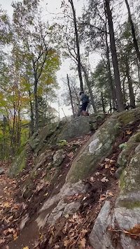
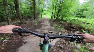
Photos of Centre Vorlage Mountain Bike
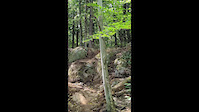
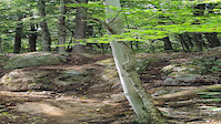
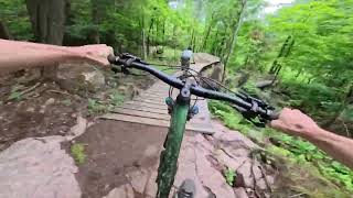
Videos of Centre Vorlage Mountain Bike

trail: Don't Cli...mb MAX
0:57 |
119 |
Oct 17, 2023

trail: Acces Shangri-La
0:38 |
246 |
Oct 17, 2023

trail: Déchaînée
3:31 |
262 |
Oct 17, 2023
trail: Acces Shangri-La
0:04 |
349 |
Oct 14, 2023
trail: Vorlage Hiking Trail
0:11 |
141 |
Sep 8, 2023
trail: Vorlage Hiking Trail
0:11 |
|
Sep 8, 2023
16:45 |
6 |
Jun 16, 2026
trail: Double Double
2:04 |
10 |
Jun 16, 2026 , Wakefield
Current Trail Warnings
| status | trail | date | condition | user | info |
|---|---|---|---|---|---|
| Verte 1 | Jun 2, 2026 @ 11:30am (America/Toronto) Jun 2, 2026 | Ideal | Alexgab CV | In maintenance | |
| Bleu 2 | Jun 2, 2026 @ 11:30am (America/Toronto) Jun 2, 2026 | Ideal | Alexgab CV | In maintenance | |
| Verte 2 | Jun 2, 2026 @ 11:30am (America/Toronto) Jun 2, 2026 | Ideal | Alexgab CV | In maintenance |
Recent Trail Reports
| status | trail | date | condition | info | user |
|---|---|---|---|---|---|
| Double Double | Jun 5, 2026 @ 2:09pm (America/Toronto) Jun 5, 2026 | Ideal | pootassium | ||
| Déchaînée | Jun 3, 2026 @ 2:45pm (America/Toronto) Jun 3, 2026 | Ideal | Alexgab CV | ||
| 1942 | Jun 3, 2026 @ 2:45pm (America/Toronto) Jun 3, 2026 | Ideal | Alexgab CV | ||
| Wonton Soup | Jun 3, 2026 @ 8:45am (America/Toronto) Jun 3, 2026 | Ideal | Alexgab CV | ||
| Roller Coaster (of love) | Jun 1, 2026 @ 3:05pm (America/Toronto) Jun 1, 2026 | Dry | cplee210 | ||
| Acces Shangri-La | May 21, 2026 @ 2:24pm (America/Toronto) May 21, 2026 | Ideal | Alexgab CV | ||
| Don't Cli...mb MAX | May 21, 2026 @ 2:24pm (America/Toronto) May 21, 2026 | Ideal | Alexgab CV | ||
| La grand boucle | May 21, 2026 @ 2:24pm (America/Toronto) May 21, 2026 | Ideal | Alexgab CV | ||
| La grand boucle | May 21, 2026 @ 2:24pm (America/Toronto) May 21, 2026 | Ideal | Alexgab CV | ||
| Chemin d'accès_4 | May 21, 2026 @ 2:24pm (America/Toronto) May 21, 2026 | Ideal | Alexgab CV |
Activity Feed
| username | action | type | title | date |
|---|---|---|---|---|
| sdrvper | add | video | activity #97133192 and 1 more | Jun 16, 2026 @ 12:59pm Jun 16, 2026 |
| Martyne | wishlist | region | activity #96932793 | Jun 13, 2026 @ 6:51pm Jun 13, 2026 |
| Alexgab | update | trail | activity #96683860 | Jun 10, 2026 @ 10:52am Jun 10, 2026 |
| sdrvper | add | video | activity #96554002 and 1 more | Jun 8, 2026 @ 11:36am Jun 8, 2026 |
| sdrvper | vote | trail | activity #96514659 | Jun 7, 2026 @ 6:48pm Jun 7, 2026 |
Recent Comments
| username | type | title | comment | date |
|---|---|---|---|---|
| trail | This is the best Vorlage blue trail as of 2026... | Jun 7, 2026 @ 6:45pm Jun 7, 2026 | ||
| trail | So fun, so fast | Jun 5, 2026 @ 11:09am Jun 5, 2026 | ||
| trail | Connect via Chemin d'accès 3 and it's a... | Jun 3, 2026 @ 8:04am Jun 3, 2026 | ||
| trail | Great addition to the network. Perfect pitch... | Sep 21, 2025 @ 8:25am Sep 21, 2025 | ||
| trail | Nouvelle montée cette année, un peu... | Oct 7, 2024 @ 1:15pm Oct 7, 2024 |
Nearby Areas
| name | distance | ||||
|---|---|---|---|---|---|
| Cantley | 9.2 km | ||||
| Camp Fortune | 12 | 16 | 16 | 6 | 10.3 km |
| Domaine Kanawe | 15 | 15 | 8 | 2 | 11.5 km |
| Parc de la Gatineau - Gatineau Park | 17 | 44 | 24 | 12.3 km | |
| Parc de Castillou | 1 | 14.4 km |
Local Badges
-

Completionist0 awarded
Activity Type Stats
| activitytype | trails | distance | descent | descent distance | total vertical | rating | global rank | state rank | photos | reports | routes | ridelogs |
|---|---|---|---|---|---|---|---|---|---|---|---|---|
| Mountain Bike | 27 | 6 miles | 2,264 ft | 4 miles | 413 ft | #4,017 | #46 | 35 | 285 | 2,662 | ||
| E-Bike | 30 | 7 miles | 2,441 ft | 4 miles | 413 ft | #4,444 | #45 | 292 | 106 | |||
| Hike | 12 | 2 miles | 190 ft | 2,323 ft | 413 ft | #9,643 | #79 | 258 | 55 | |||
| Trail Running | 10 | 2 miles | 190 ft | 2,323 ft | 413 ft | #11,225 | #101 | 127 | 84 | |||
| Snowshoe | 4 | #1,176 | #53 | 27 | 1 | |||||||
| Downhill Ski | 5 | #412 | #10 | 157 | 118 |
Frequently Asked Questions About Centre Vorlage
▼
What are the highest rated mountain biking trails in Centre Vorlage?
The highest rated mountain biking trails in Centre Vorlage are:
- Double Double (4.5/5)
- Don't Cli...mb MAX (4.4/5)
- 1942 (4.3/5)
- Wonton Soup (4.3/5)
- Lost Horizons (4.2/5)
▼
Where can I park to ride in Centre Vorlage?
▼
What is the longest trail in Centre Vorlage?
The longest trail in Centre Vorlage is Roller Coaster (of love) at 2.7 km. View all trails sorted by distance.
▼
What are the best & highest rated hiking trails in Centre Vorlage?
The best hiking trails in Centre Vorlage are: View all hiking trails sorted by popularity score.
Activities
- By StephaneMarceau
 TRAILFORKS & contributors
 - Admins: CV
- #58769 - 17,226 views
- centre vorlage activity log | embed map of Centre Vorlage mountain bike trails | centre vorlage mountain biking points of interest polygons
Downloading of trail gps tracks in kml & gpx formats is enabled for Centre Vorlage.
You must login to download files.