close
-
Layers w
- Weather Layers
- Pro
- Pro
- Pro
- Pro
- Pro
- Pro
- More Layers
- Pro
- Pro
- Pro
- Pro
-
Upgrade to

3D
Trail Conditions
- Unknown
- Snow Groomed
- Snow Packed
- Snow Covered
- Snow Cover Partial
- Freeze/thaw Cycle
- Icy
- Prevalent Mud
- Wet
- Variable
- Ideal
- Dry
- Very Dry
Trail Flow (Ridden Direction)
Trailforks scans users ridelogs to determine the most popular direction each trail is ridden. A good flowing trail network will have most trails flowing in a single direction according to their intension.
The colour categories are based on what percentage of riders are riding a trail in its intended direction.
The colour categories are based on what percentage of riders are riding a trail in its intended direction.
- > 96%
- > 90%
- > 80%
- > 70%
- > 50%
- < 50%
- bi-directional trail
- no data
Trail Last Ridden
Trailforks scans ridelogs to determine the last time a trail was ridden.
- < 2 days
- < 1 week
- < 2 weeks
- < 1 month
- < 6 months
- > 6 months
Trail Ridden Direction
The intended direction a trail should be ridden.
- Downhill Only
- Downhill Primary
- Both Directions
- Uphill Primary
- Uphill Only
- One Direction
Contribute Details
Colors indicate trail is missing specified detail.
- Description
- Photos
- Description & Photos
- Videos
Trail Popularity ?
Trailforks scans ridelogs to determine which trails are ridden the most in the last 9 months.
Trails are compared with nearby trails in the same city region with a possible 25 colour shades.
Think of this as a heatmap, more rides = more kinetic energy = warmer colors.
- most popular
- popular
- less popular
- not popular
ATV/ORV/OHV Filter
Max Vehicle Width
inches
US Cell Coverage
Legend

Radar Time
Activity Recordings
Trailforks uses anonymized public activity data.
?
Activity Recordings
Trailforks uses anonymized public activity data.
?
Personal Heatmap
▶
Activity Types
all
/
none
▶
Options
2
Date range
month
–
Winter Trails
Warning
A routing network for winter maps does not exist. Selecting trails using the winter trails layer has been disabled.
Missing Trails
Most Popular
Least Popular
Trails are colored based on popularity. The more popular a trail is, the more red. Less popular trails trend towards green.
Jump Magnitude Heatmap
Heatmap of where riders jump on trails. Zoom in to see individual jumps, click circles to view jump details.
BC Backroad Status
![map legend]()
Service Road Atlas is a free to use, community-driven service for viewing and creating reports on the numerous back-country service roads around B.C. and Alberta.

Slope Aspect
Direction the slope faces
Trails Deemphasized
Trails are shown in grey.
Only show trails with no bike usage.
Suggested Layers
Based on selected activity type
Save the current map location and zoom level as your default home location whenever this page is loaded.
SaveBike Park Closed for Season. Opens on July 1
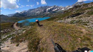
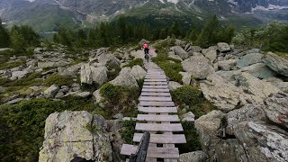
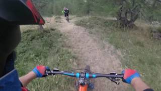
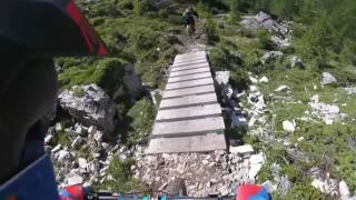
The Matterhorn Valley, one of the most popular areas for this sporting discipline, offers its guest many mountain bike trails: off road trails and the well equipped Bike Park means everyone will be happy.
Breuil-Cervinia is also home to the international downhill event Maxiavalanche, to be held this year on the 26th and 27th July, (www.megavalanche.com / www.facebook.com/maxiavalanchecervinia) in its 10th year. An exciting competition with over 400 participants from all over the world in a challenge of over 12 km from the snow on the glacier of Plateau Rosà down to the green pastures of Plan Maison and arrival in town.
Bike hire in the area for those whom travel without, or those wishing to try a different discipline. Click here to see the videos of our trails and follow us on facebook for more information
www.facebook.com/BikeParkCerviniaValtournenche
This region uses the Uk/Euro style trail grading system.
Activities Click to view
- Mountain Bike
31 trails
- E-Bike
25 trails
- Hike
17 trails
- Trail Running
17 trails
Bike Park Details
- 7
- 5
- 5
- 1
- 1
Region Status
Open as of Sep 17, 2025- Day Ticket
- 20
- Season start
- Jul 1
- Season end
- Sep 15
Stats
- Avg Trail Rating
- Global Ranking
- #2,545
- Trails (view details)
- 26
- Trails Mountain Bike
- 31
- Trails E-Bike
- 25
- Trails Horse
- 2
- Trails Hike
- 17
- Trails Trail Running
- 17
- Total Distance
- 45 miles
- Total Descent
- 18,182 ft
- Total Vertical
- 4,347 ft
- Highest Trailhead
- 9,233 ft
- Reports
- 117
- Photos
- 65
- Ridden Counter
- 2,465
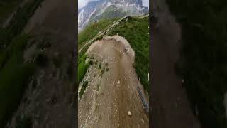
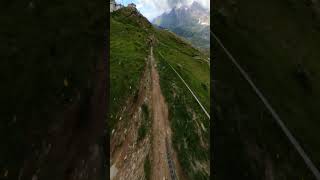
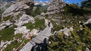
Popular Cervino Mountain Biking Trails
• 100 ★ 3.5 • 1 mile • 14 ft • 291 •
Intermediate level trail, ideal for those whom have a good technique of the downhill discipline. Along the trail numerous drops, parabolic curves and variants to try over and over again.
• 90 ★ 4.2 • 1 mile • 8 ft • 259 •
Intermediate level trail, ideal for the freeride enthusiasts. Man-made structures completing the technical aspects of the course.
• 85 ★ 4.8 • 2,543 ft • 5 ft • 257 •
With a length of about 1 km. 160 meters of negative gradient and an average gradient of 16.6%, can be considered the most challenging trail in the Cervino Bike Park. Made for the 30% with boardwalks, you will reach after about 3000...
• 75 ★ 4.7 • 4,741 ft • 0 ft • 187 •
This trail starts half way along and unwinds through the woods in the area of the lake "Lago Bleu".
• 95 ★ 5.0 • 3,389 ft • 50 ft • 91 •
Nice singletrack on a old rail train. Nice view !
• 100 ★ 4.0 • 2 miles • 9 ft • 90 •
This long trail is very fun and a little technical. The first section isn't too steep. After a while there is an easy enough rock face with a chicken line option. After the little bridge there's a techy rock section which you might want...
• 50 ★ 3.5 • 1 mile • 0 ft • 88 •
This trail follows the winter ski runs in the area, it starts half way along .
• 60 ★ 0.0 • 3 miles • 861 ft • 85 •
The starts just under the chairlift "Motta" near the arrival station of the cable car Salette and crosses over the pastures between Cime Bianche and the roads that lead to the stables of the "Mande". The trail has a positive altitude...
Cervino Mountain Bike Routes
18 miles • 4,664 ft • 0 •
Very scenic tour mostly on double track and very tough climbs...enjoy!
• 2 miles • 37 ft • 2 •
Photos of Cervino Mountain Bike
Videos of Cervino Mountain Bike
youtuber
![Plan Maison 1B - Cervinia Bike Park #mtb...]()
trail: PLAN MAISON
0:18 |
180 |
Aug 9, 2024 , Valtournenche
youtuber
![Plan Maison 1B - Cervinia Bike Park]()
trail: PLAN MAISON
0:22 |
131 |
Mar 30, 2024 , Valtournenche
youtuber
![Roock&Wood - Cervinia Bike Park]()
trail: Rock & Wood
4:18 |
390 |
Jul 15, 2022 , Valtournenche
trail: Rock & Wood
11:42 |
219 |
Sep 14, 2022 , Valtournenche
youtuber
![Cime Bianche - Cervinia Bike Park]()
trail: Cime Bianche Laghi
9:30 |
392 |
Jul 15, 2022 , Valtournenche
trail: Rock & Wood
579 |
May 6, 2017 , Valtournenche
trail: Rock & Wood
690 |
May 6, 2017 , Valtournenche
Recent Trail Reports
| status | trail | date | condition | info | user |
|---|---|---|---|---|---|
| Cieloalto | Aug 23, 2025 @ 11:52am Aug 23, 2025 | Ideal | MG74 | ||
| Alpage | Aug 23, 2025 @ 11:51am Aug 23, 2025 | Ideal | MG74 | ||
| Cime Bianche Laghi | Aug 23, 2025 @ 10:45am Aug 23, 2025 | Dry | MG74 | ||
| Layet | Aug 23, 2025 @ 4:04pm Aug 23, 2025 | Ideal | MG74 | ||
| Cime Bianche | Aug 23, 2025 @ 4:04pm Aug 23, 2025 | Dry | MG74 | ||
| Rock & Wood | Aug 23, 2025 @ 2:46pm Aug 23, 2025 | Ideal | MG74 | ||
| Vecchia Linea Ferroviaria | Aug 23, 2025 @ 2:46pm Aug 23, 2025 | Ideal | MG74 | ||
| CIME STRONG TRAIL | Aug 23, 2025 @ 2:46pm Aug 23, 2025 | Dry | MG74 | ||
| Plan Maison | Aug 12, 2025 @ 9:47am Aug 12, 2025 | Very Dry | maciejas | ||
| Manda paved road | Aug 13, 2025 @ 11:20am Aug 13, 2025 | Ideal | Danialus |
Activity Feed
| username | action | type | title | date |
|---|---|---|---|---|
| FilippoQKfWKk | ridden | trail | activity #92306793 | Apr 10, 2026 @ 1:31am Apr 10, 2026 |
| nhudson99 | wishlist | trail | activity #90170750 | Mar 7, 2026 @ 7:38pm Mar 7, 2026 |
| shopsclose | wishlist | trail | activity #87408832 | Jan 18, 2026 @ 7:09am Jan 18, 2026 |
| sricard12 | wishlist | trail | activity #86834534 | Jan 7, 2026 @ 10:58pm Jan 7, 2026 |
| anzebizjak | ridden | trail | activity #86707592 | Jan 5, 2026 @ 12:54pm Jan 5, 2026 |
Recent Comments
| username | type | title | comment | date |
|---|---|---|---|---|
| trail | Please consider to rate the trail using the... | Sep 16, 2024 @ 1:39am Sep 16, 2024 | ||
| trail | Please consider to rate the trail using the... | Sep 16, 2024 @ 1:39am Sep 16, 2024 | ||
| trail | I think the same, should be red | Sep 15, 2024 @ 11:28am Sep 15, 2024 | ||
| trail | Should be red as it is more difficult than the... | Aug 27, 2024 @ 9:48am Aug 27, 2024 | ||
| trail | I'd rate Cime Bianche blue and Cime Bianche... | Aug 27, 2024 @ 9:45am Aug 27, 2024 |
Nearby Areas
| name | distance | ||||
|---|---|---|---|---|---|
| Val d'Ayas | 9 | 10 | 3 | 1 | 8 km |
| Gressoney Bike | 1 | 1 | 2 | 8.7 km | |
| Zermatt - Matterhorn | 29 | 64 | 8.9 km | ||
| Monterosa Resort | 1 | 1 | 9.8 km | ||
| Gressoney Bike Park | 2 | 13.7 km |
Local Badges
-

Completionist0 awarded
Activity Type Stats
| activitytype | trails | distance | descent | descent distance | total vertical | rating | global rank | state rank | photos | reports | routes | ridelogs |
|---|---|---|---|---|---|---|---|---|---|---|---|---|
| Mountain Bike | 31 | 45 miles | 18,182 ft | 24 miles | 4,347 ft | #2,545 | 65 | 117 | 1 | 1,433 | ||
| E-Bike | 25 | 43 miles | 16,227 ft | 22 miles | 4,347 ft | #2,190 | #156 | 114 | 356 | |||
| Horse | 2 | 8 miles | 784 ft | 2 miles | 3,232 ft | 12 | ||||||
| Hike | 17 | 20 miles | 5,820 ft | 10 miles | 4,314 ft | #4,499 | #121 | 91 | 416 | |||
| Trail Running | 17 | 20 miles | 5,820 ft | 10 miles | 4,314 ft | #3,777 | #118 | 91 | 105 |
Frequently Asked Questions About Cervino
▼
What are the highest rated mountain biking trails in Cervino?
The highest rated mountain biking trails in Cervino are:
- Rock & Wood (4.3/5)
- Vecchia Linea Ferroviaria (4.2/5)
- La Spina (4.2/5)
- Alpage (4.2/5)
- Layet (4.2/5)
▼
What is the best time of the year to ride in Cervino?
Based on ride log data, the most popular months to ride in Cervino are:
- July (38 activities)
- August (12 activities)
- September (3 activities)
▼
Where can I park to ride in Cervino?
Check the Cervino trail map for trailhead and parking information. Community members regularly update access and parking details for trails in the area.
▼
What is the longest trail in Cervino?
The longest trail in Cervino is La balconata at 3.4 miles. View all trails sorted by distance.
- By brenthillier
 NSMBA TRAILFORKS & contributors
 - Admins: apply
- #4168 - 10,187 views
- cervino activity log | embed map of Cervino mountain bike trails |
Downloading of trail gps tracks in kml & gpx formats is enabled for Cervino.
You must login to download files.