close
-
Layers w
- Weather Layers
- Pro
- Pro
- Pro
- Pro
- Pro
- Pro
- More Layers
- Pro
- Pro
- Pro
- Pro
-
Upgrade to

3D
Trail Conditions
- Unknown
- Snow Groomed
- Snow Packed
- Snow Covered
- Snow Cover Partial
- Freeze/thaw Cycle
- Icy
- Prevalent Mud
- Wet
- Variable
- Ideal
- Dry
- Very Dry
Trail Flow (Ridden Direction)
Trailforks scans users ridelogs to determine the most popular direction each trail is ridden. A good flowing trail network will have most trails flowing in a single direction according to their intension.
The colour categories are based on what percentage of riders are riding a trail in its intended direction.
The colour categories are based on what percentage of riders are riding a trail in its intended direction.
- > 96%
- > 90%
- > 80%
- > 70%
- > 50%
- < 50%
- bi-directional trail
- no data
Trail Last Ridden
Trailforks scans ridelogs to determine the last time a trail was ridden.
- < 2 days
- < 1 week
- < 2 weeks
- < 1 month
- < 6 months
- > 6 months
Trail Ridden Direction
The intended direction a trail should be ridden.
- Downhill Only
- Downhill Primary
- Both Directions
- Uphill Primary
- Uphill Only
- One Direction
Contribute Details
Colors indicate trail is missing specified detail.
- Description
- Photos
- Description & Photos
- Videos
Trail Popularity ?
Trailforks scans ridelogs to determine which trails are ridden the most in the last 9 months.
Trails are compared with nearby trails in the same city region with a possible 25 colour shades.
Think of this as a heatmap, more rides = more kinetic energy = warmer colors.
- most popular
- popular
- less popular
- not popular
ATV/ORV/OHV Filter
Max Vehicle Width
inches
US Cell Coverage
Legend

Radar Time
Activity Recordings
Trailforks uses anonymized public activity data.
?
Activity Recordings
Trailforks uses anonymized public activity data.
?
Personal Heatmap
▶
Activity Types
all
/
none
▶
Options
2
Date range
month
–
Winter Trails
Warning
A routing network for winter maps does not exist. Selecting trails using the winter trails layer has been disabled.
Missing Trails
Most Popular
Least Popular
Trails are colored based on popularity. The more popular a trail is, the more red. Less popular trails trend towards green.
Jump Magnitude Heatmap
Heatmap of where riders jump on trails. Zoom in to see individual jumps, click circles to view jump details.
BC Backroad Status
![map legend]()
Service Road Atlas is a free to use, community-driven service for viewing and creating reports on the numerous back-country service roads around B.C. and Alberta.

Slope Aspect
Direction the slope faces
Trails Deemphasized
Trails are shown in grey.
Only show trails with no bike usage.
Suggested Layers
Based on selected activity type
Save the current map location and zoom level as your default home location whenever this page is loaded.
Save
No description for Chamonix has been added yet!
Login or register to submit one.
This region uses the Uk/Euro style trail grading system.
Activities Click to view
- Mountain Bike
93 trails
- E-Bike
46 trails
- Gravel Bike
86 trails
- Adaptive Bike
12 trails
- Hike
99 trails
- Trail Running
99 trails
- Downhill Ski
460 trails
- Backcountry Ski
14 trails
Region Details
- 20
- 16
- 19
- 18
- 19
- 1
Region Status
Open as of Nov 11, 2025Stats
- Avg Trail Rating
- Trails (view details)
- 584
- Trails Mountain Bike
- 93
- Trails E-Bike
- 46
- Trails Gravel Bike
- 86
- Trails Adaptive Bike
- 12
- Trails Winter Fat Bike
- 1
- Trails Hike
- 99
- Trails Trail Running
- 99
- Trails Downhill Ski
- 460
- Trails Backcountry Ski
- 14
- Total Distance
- 430 miles
- Total Descent
- 329,859 ft
- Total Vertical
- 12,879 ft
- Highest Trailhead
- 15,184 ft
- Reports
- 253
- Photos
- 416
- Ridden Counter
- 60,796
Articles
You Don't Have to Be a Freeride World Tour Skier to Notch Some of Chamonix's Classic Descents
Nov 25, 2021 from skimag.com
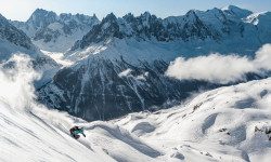
Chamonix is known for its extreme terrain, bucket-list views, culture, and more.
Sub Regions
-
Balme/Les Autannes – Vallorcine/Le Tour
- 1
-
Le Tour-Montroc
- 1
Popular Chamonix Mountain Biking Trails
• 100 ★ 3.0 • 951 ft • 49 ft • 237 •
Popular green difficulty singletrack. This mountain bike primary trail can be used both directions. On average it takes minutes to complete this trail.
• 100 ★ 4.7 • 2 miles • 157 ft • 233 •
WARNING : Trail closed to MTB in JULY AND AUGUST ATTENTION : le traile est fermé au VTT au mois de juillet et d'aout ! Nice and long trail. Lots of hairpin turns. Terrain at the top if rocky and smoother at the bottom Climb via the ski...
• 100 ★ 2.5 • 820 ft • 0 ft • 228 •
Popular black difficulty singletrack. This mountain bike primary trail can be used both directions. On average it takes 1 minutes to complete this trail.
• 90 ★ 4.0 • 2 miles • 306 ft • 205 •
Beware : not to be ridden in July-August (bike ban). One of the best descents in the valley : flowy, techy, fast. Just great. Starts with a little climb (5 to 10min).
• 95 ★ 2.0 • 459 ft • 12 ft • 168 •
Popular green difficulty singletrack. This mountain bike primary trail can be used both directions. On average it takes minutes to complete this trail.
• 95 ★ 0.0 • 440 ft • 22 ft • 153 •
Popular green difficulty singletrack. This mountain bike primary trail can be used both directions. On average it takes minutes to complete this trail.
• 85 ★ 4.0 • 1,693 ft • 0 ft • 146 •
Short sweet ride for roughly 2km and 300m of pure downhill. Pretty rocky but nothing too technical. Some jumps here and there. Still worth the climb up + can be combined with right after that. Trail starts just under the arrival of...
Chamonix Mountain Bike Routes
11 miles • 2,490 ft • 0 • Loop •
nice recommendable loop to the Lac Vert and back to Servoz.
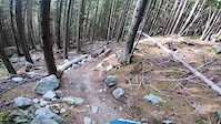
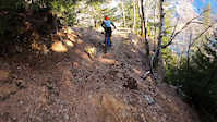
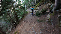
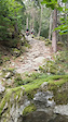
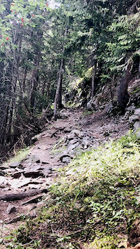
Photos of Chamonix Mountain Bike
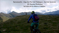
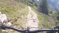
Videos of Chamonix Mountain Bike
trail: Brown Snake
0:26 |
109 |
Nov 8, 2022
trail: Merlet
0:12 |
155 |
Mar 27, 2022
trail: Merlet
0:12 |
103 |
Mar 27, 2022
trail: Petit Balcon Sud
0:34 |
86 |
Jul 15, 2021

trail: Sentier des Gardes
8:33 |
131 |
Nov 1, 2020
trail: Charlanon
0:12 |
305 |
Aug 29, 2020
trail: Les Bois
8:38 |
252 |
Sep 10, 2019
trail: Col des Posettes Partie 1
0:29 |
332 |
Oct 9, 2017
Recent Trail Reports
Activity Feed
| username | action | type | title | date |
|---|---|---|---|---|
| FgIagk | wishlist | trail | activity #97822098 and 1 more | Jun 26, 2026 @ 2:20am 1 day |
| enforce | wishlist | trail | activity #97673871 | Jun 23, 2026 @ 9:09pm Jun 23, 2026 |
| matoi3RRXl | vote | trail | activity #97566289 and 4 more | Jun 22, 2026 @ 9:13am Jun 22, 2026 |
| tonylau | vote | trail | activity #97560931 | Jun 22, 2026 @ 7:39am Jun 22, 2026 |
| FgIagk | wishlist | trail | activity #97506043 and 1 more | Jun 21, 2026 @ 11:39am Jun 21, 2026 |
Recent Comments
| username | type | title | comment | date |
|---|---|---|---|---|
| trail | Pretty good. Nothing crazy just a bunch of... | Sep 17, 2025 @ 7:10am Sep 17, 2025 | ||
| trail | I rode it August 2025 from the top on an... | Aug 8, 2025 @ 11:08am Aug 8, 2025 | ||
| trail | New trail from 2023 ! | Jul 14, 2025 @ 3:02am Jul 14, 2025 | ||
| trail | Really enjoyed the technicality of this trail;... | Sep 2, 2024 @ 5:12am Sep 2, 2024 | ||
| trail | Really enjoyed the technicality of this trail;... | Sep 2, 2024 @ 5:09am Sep 2, 2024 |
Local Badges
-

Epic Ride Climb 2k352 awarded -

Climbing 10k Badge53 awarded -

Climbing 100k Badge1 awarded -

Epic Ride Descent 2k504 awarded -

Descent 10k Badge70 awarded -

Descent 100k Badge2 awarded
Activity Type Stats
| activitytype | trails | distance | descent | descent distance | total vertical | rating | global rank | state rank | photos | reports | routes | ridelogs |
|---|---|---|---|---|---|---|---|---|---|---|---|---|
| Mountain Bike | 93 | 96 miles | 42,087 ft | 54 miles | 5,558 ft | #1,118 | #18 | 402 | 241 | 1 | 4,612 | |
| E-Bike | 46 | 60 miles | 25,344 ft | 33 miles | 5,558 ft | #534 | #43 | 11 | 220 | 735 | ||
| Gravel Bike | 86 | 66 miles | 26,201 ft | 37 miles | 6,263 ft | #43 | #30 | 8 | 25 | |||
| Adaptive Bike | 12 | 13 miles | 1,611 ft | 4 miles | 3,159 ft | #104 | #117 | 32 | ||||
| Winter Fat Bike | 1 | 3,018 ft | 33 ft | 787 ft | 39 ft | #2,401 | #42 | 1 | ||||
| Hike | 99 | 110 miles | 46,798 ft | 57 miles | 5,558 ft | #686 | #18 | 2 | 238 | 4,554 | ||
| Trail Running | 99 | 110 miles | 46,798 ft | 57 miles | 5,558 ft | #515 | #18 | 1 | 238 | 2,848 | ||
| Downhill Ski | 460 | 279 miles | 257,510 ft | 261 miles | 9,797 ft | #6 | #1 | 9 | 7,615 | |||
| Backcountry Ski | 14 | 32 miles | 19,606 ft | 17 miles | 11,818 ft | #28 | #3 | 8 | 3,517 |
Frequently Asked Questions About Chamonix
▼
What are the best places to ride in Chamonix?
Chamonix has 9 areas to explore for mountain biking. The top rated areas are:
▼
What are the highest rated mountain biking trails in Chamonix?
The highest rated mountain biking trails in Chamonix are:
- Col des Posettes Partie 1 (4.4/5)
- Montagne Des Posettes Partie 1 (4.3/5)
- Merlet (4.3/5)
- Col Des Posettes Partie 2 (4.2/5)
- Montagne Des Posettes Partie 2 (4.2/5)
▼
What is the best time of the year to ride in Chamonix?
Based on ride log data, the most popular months to ride in Chamonix are:
- July (52 activities)
- October (51 activities)
- August (48 activities)
▼
Where can I park to ride in Chamonix?
There are 7 parking locations listed in Chamonix. The most popular parking spots are:
- Wicket Creek Lot "Parking Lot #1"
- Tour du Pays du Mont-Blanc
- Parking Du Planards
- Parking du Brévent
- Petit Balcon Sud
Activities
Trails
- By Whipperman
 & contributors
 - Admins: alltta, freerider48, maxlatourte, Charliedp, Whipperman
- #8527 - 29,154 views
- chamonix activity log | embed map of Chamonix mountain bike trails | chamonix mountain biking points of interest polygons
Downloading of trail gps tracks in kml & gpx formats is enabled for Chamonix.
You must login to download files.