close
-
Layers w
- Weather Layers
- Pro
- Pro
- Pro
- Pro
- Pro
- Pro
- More Layers
- Pro
- Pro
- Pro
- Pro
-
Upgrade to

3D
Trail Conditions
- Unknown
- Snow Groomed
- Snow Packed
- Snow Covered
- Snow Cover Partial
- Freeze/thaw Cycle
- Icy
- Prevalent Mud
- Wet
- Variable
- Ideal
- Dry
- Very Dry
Trail Flow (Ridden Direction)
Trailforks scans users ridelogs to determine the most popular direction each trail is ridden. A good flowing trail network will have most trails flowing in a single direction according to their intension.
The colour categories are based on what percentage of riders are riding a trail in its intended direction.
The colour categories are based on what percentage of riders are riding a trail in its intended direction.
- > 96%
- > 90%
- > 80%
- > 70%
- > 50%
- < 50%
- bi-directional trail
- no data
Trail Last Ridden
Trailforks scans ridelogs to determine the last time a trail was ridden.
- < 2 days
- < 1 week
- < 2 weeks
- < 1 month
- < 6 months
- > 6 months
Trail Ridden Direction
The intended direction a trail should be ridden.
- Downhill Only
- Downhill Primary
- Both Directions
- Uphill Primary
- Uphill Only
- One Direction
Contribute Details
Colors indicate trail is missing specified detail.
- Description
- Photos
- Description & Photos
- Videos
Trail Popularity ?
Trailforks scans ridelogs to determine which trails are ridden the most in the last 9 months.
Trails are compared with nearby trails in the same city region with a possible 25 colour shades.
Think of this as a heatmap, more rides = more kinetic energy = warmer colors.
- most popular
- popular
- less popular
- not popular
ATV/ORV/OHV Filter
Max Vehicle Width
inches
US Cell Coverage
Legend

Radar Time
Activity Recordings
Trailforks uses anonymized public activity data.
?
Activity Recordings
Trailforks uses anonymized public activity data.
?
Personal Heatmap
▶
Activity Types
all
/
none
▶
Options
2
Date range
month
–
Winter Trails
Warning
A routing network for winter maps does not exist. Selecting trails using the winter trails layer has been disabled.
Missing Trails
Most Popular
Least Popular
Trails are colored based on popularity. The more popular a trail is, the more red. Less popular trails trend towards green.
Jump Magnitude Heatmap
Heatmap of where riders jump on trails. Zoom in to see individual jumps, click circles to view jump details.
BC Backroad Status
![map legend]()
Service Road Atlas is a free to use, community-driven service for viewing and creating reports on the numerous back-country service roads around B.C. and Alberta.

Slope Aspect
Direction the slope faces
Trails Deemphasized
Trails are shown in grey.
Only show trails with no bike usage.
Suggested Layers
Based on selected activity type
Save the current map location and zoom level as your default home location whenever this page is loaded.
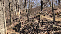
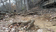
SaveCherokee park trails are technical and flat, there have great speed mixed with few climbs great XC singletrack.
 google parking directions
 Activities Click to view
- Mountain Bike
18 trails
- Hike
18 trails
- Trail Running
18 trails
Region Details
- 2
- 6
- 10
Region Status
Open as of May 9, 2026Stats
- Avg Trail Rating
- Trails (view details)
- 19
- Trails Mountain Bike
- 18
- Trails Hike
- 18
- Trails Trail Running
- 18
- Total Distance
- 9 miles
- Total Descent
- 846 ft
- Total Vertical
- 101 ft
- Highest Trailhead
- 541 ft
- Reports
- 1,626
- Photos
- 71
- Ridden Counter
- 4,866
Popular Cherokee Park Mountain Biking Trails
• 95 ★ 4.8 • 1,713 ft • 36 ft • 397 •
Popular blue difficulty singletrack. This mountain bike primary trail can be used both directions. On average it takes 2 minutes to complete this trail.
• 80 ★ 4.0 • 2,564 ft • 49 ft • 384 •
Flat and flowy trail with a few small drops and rocky sections.
• 90 ★ 4.8 • 3,516 ft • 78 ft • 378 •
Popular blue difficulty singletrack. This mountain bike primary trail can be used both directions. On average it takes 5 minutes to complete this trail.
• 80 ★ 4.4 • 5,152 ft • 116 ft • 346 •
Popular blue difficulty singletrack. This mountain bike primary trail can be used both directions. On average it takes 8 minutes to complete this trail.
• 75 ★ 0.0 • 2,237 ft • 71 ft • 296 •
Popular green difficulty singletrack. This mountain bike primary trail can be used both directions. On average it takes 3 minutes to complete this trail.
• 65 ★ 4.0 • 1,240 ft • 7 ft • 287 •
Moderately popular green difficulty singletrack. This mountain bike primary trail can be used both directions. On average it takes 1 minutes to complete this trail.
• 90 ★ 4.3 • 5,039 ft • 61 ft • 277 •
Highly rated popular blue difficulty singletrack. This mountain bike primary trail can be used both directions. On average it takes 8 minutes to complete this trail.
• 55 ★ 4.8 • 1 mile • 116 ft • 267 •
Moderately popular blue difficulty singletrack. This mountain bike primary trail. On average it takes 9 minutes to complete this trail.
Cherokee Park Mountain Bike Routes
★ 3.0 • 11 miles • 737 ft • 22 • Loop •
Classic Cherokee to Seneca Loop, starting at the Gravel lot / Frisbee / Rugby Field. Counter Clockwise is...
• 14 miles • 776 ft • 19 •
• 13 miles • 715 ft • 16 •
• 14 miles • 883 ft • 23 •
• 11 miles • 930 ft • 18 •
Photos of Cherokee Park Mountain Bike
Videos of Cherokee Park Mountain Bike
trail: Cherokee Loop
0:09 |
45 |
Jul 10, 2024
trail: Cherokee Loop
0:09 |
302 |
Nov 19, 2019

trail: Cherokee Loop
0:28 |
262 |
Apr 19, 2018
Recent Trail Reports
Activity Feed
| username | action | type | title | date |
|---|---|---|---|---|
| ChuckNorrisTXn | add | photo | activity #94803171 | May 16, 2026 @ 4:51am May 16, 2026 |
| ChuckNorrisTXn | add | photo | activity #94645040 | May 13, 2026 @ 12:53pm May 13, 2026 |
| rmack1970 | add | report | activity #94394687 and 10 more | May 9, 2026 @ 7:04pm May 9, 2026 |
| oblouky | add | report | activity #93249653 and 11 more | Apr 23, 2026 @ 5:00pm Apr 23, 2026 |
| geezerjock | wishlist | region | activity #92749919 | Apr 16, 2026 @ 3:04pm Apr 16, 2026 |
Recent Comments
| username | type | title | comment | date |
|---|---|---|---|---|
| report | Dog park. Can't type with gloves | Apr 4, 2022 @ 7:35am Apr 4, 2022 | ||
| trail | Fun best thing was I went n afternoon and the... | Oct 16, 2020 @ 4:53am Oct 16, 2020 | ||
| report | Still a little wet from the rain two days ago | Jun 6, 2020 @ 7:00am Jun 6, 2020 | ||
| report | Thank you! | Mar 26, 2020 @ 2:32pm Mar 26, 2020 | ||
| report | Cherokee and Seneca should be good to go | Mar 26, 2020 @ 1:34pm Mar 26, 2020 |
Nearby Areas
| name | distance | ||||
|---|---|---|---|---|---|
| Seneca Park | 6 | 1 | 1 km | ||
| Mega Cavern | 2.6 km | ||||
| E.P. Tom Sawyer Park | 8.1 km | ||||
| Waverly | 4 | 10 km | |||
| Brair Hill Park | 2 | 3 | 11.1 km |
Activity Type Stats
| activitytype | trails | distance | descent | descent distance | total vertical | rating | global rank | state rank | photos | reports | routes | ridelogs |
|---|---|---|---|---|---|---|---|---|---|---|---|---|
| Mountain Bike | 18 | 9 miles | 787 ft | 4 miles | 98 ft | #1,560 | #533 | 71 | 1,626 | 2 | 16,131 | |
| Hike | 18 | 9 miles | 817 ft | 4 miles | 102 ft | #12,132 | #4,997 | 1,625 | 147 | |||
| Trail Running | 18 | 9 miles | 817 ft | 4 miles | 102 ft | #9,325 | #3,367 | 1,625 | 1,080 |
Frequently Asked Questions About Cherokee Park
▼
What are the highest rated mountain biking trails in Cherokee Park?
The highest rated mountain biking trails in Cherokee Park are:
- All Downhill From Here (4.6/5)
- Cherokee Loop (4.4/5)
- Cherokee Loop (4.3/5)
- Cherokee Loop (4.3/5)
- Cherokee Loop (4.2/5)
▼
What is the best time of the year to ride in Cherokee Park?
Based on ride log data, the most popular months to ride in Cherokee Park are:
- July (95 activities)
- August (40 activities)
- September (32 activities)
▼
Where can I park to ride in Cherokee Park?
There are 3 parking locations listed in Cherokee Park. The most popular parking spots are: View all parking and trailhead locations on the map to plan your visit.
▼
What is the longest trail in Cherokee Park?
The longest trail in Cherokee Park is Cherokee Loop at 1.5 miles. View all trails sorted by distance.
Activities
- By brenthillier
 NSMBA TRAILFORKS & contributors
 - Admins: apply
- #6887 - 14,056 views
- cherokee park activity log | embed map of Cherokee Park mountain bike trails | cherokee park mountain biking points of interest
Downloading of trail gps tracks in kml & gpx formats is enabled for Cherokee Park.
You must login to download files.