close
-
Layers w
- Weather Layers
- Pro
- Pro
- Pro
- Pro
- Pro
- Pro
- More Layers
- Pro
- Pro
- Pro
- Pro
-
Upgrade to

3D
Trail Conditions
- Unknown
- Snow Groomed
- Snow Packed
- Snow Covered
- Snow Cover Partial
- Freeze/thaw Cycle
- Icy
- Prevalent Mud
- Wet
- Variable
- Ideal
- Dry
- Very Dry
Trail Flow (Ridden Direction)
Trailforks scans users ridelogs to determine the most popular direction each trail is ridden. A good flowing trail network will have most trails flowing in a single direction according to their intension.
The colour categories are based on what percentage of riders are riding a trail in its intended direction.
The colour categories are based on what percentage of riders are riding a trail in its intended direction.
- > 96%
- > 90%
- > 80%
- > 70%
- > 50%
- < 50%
- bi-directional trail
- no data
Trail Last Ridden
Trailforks scans ridelogs to determine the last time a trail was ridden.
- < 2 days
- < 1 week
- < 2 weeks
- < 1 month
- < 6 months
- > 6 months
Trail Ridden Direction
The intended direction a trail should be ridden.
- Downhill Only
- Downhill Primary
- Both Directions
- Uphill Primary
- Uphill Only
- One Direction
Contribute Details
Colors indicate trail is missing specified detail.
- Description
- Photos
- Description & Photos
- Videos
Trail Popularity ?
Trailforks scans ridelogs to determine which trails are ridden the most in the last 9 months.
Trails are compared with nearby trails in the same city region with a possible 25 colour shades.
Think of this as a heatmap, more rides = more kinetic energy = warmer colors.
- most popular
- popular
- less popular
- not popular
ATV/ORV/OHV Filter
Max Vehicle Width
inches
US Cell Coverage
Legend

Radar Time
Activity Recordings
Trailforks uses anonymized public activity data.
?
Activity Recordings
Trailforks uses anonymized public activity data.
?
Personal Heatmap
▶
Activity Types
all
/
none
▶
Options
2
Date range
month
–
Winter Trails
Warning
A routing network for winter maps does not exist. Selecting trails using the winter trails layer has been disabled.
Missing Trails
Most Popular
Least Popular
Trails are colored based on popularity. The more popular a trail is, the more red. Less popular trails trend towards green.
Jump Magnitude Heatmap
Heatmap of where riders jump on trails. Zoom in to see individual jumps, click circles to view jump details.
BC Backroad Status
![map legend]()
Service Road Atlas is a free to use, community-driven service for viewing and creating reports on the numerous back-country service roads around B.C. and Alberta.

Slope Aspect
Direction the slope faces
Trails Deemphasized
Trails are shown in grey.
Only show trails with no bike usage.
Suggested Layers
Based on selected activity type
Save the current map location and zoom level as your default home location whenever this page is loaded.
Save
No description for Cheyenne has been added yet!
Login or register to submit one.
Activities Click to view
- Mountain Bike
82 trails
- E-Bike
63 trails
- Gravel Bike
0 trails
- Adaptive Bike
0 trails
- Horse
4 trails
- Hike
81 trails
- Trail Running
81 trails
Region Details
- 2
- 8
- 16
- 28
- 14
- 14
Region Status
Open as of May 20, 2026Stats
- Avg Trail Rating
- Trails (view details)
- 85
- Trails Mountain Bike
- 82
- Trails E-Bike
- 63
- Trails Horse
- 4
- Trails Hike
- 81
- Trails Trail Running
- 81
- Total Distance
- 60 miles
- Total Descent
- 10,332 ft
- Total Vertical
- 1,724 ft
- Highest Trailhead
- 7,696 ft
- Reports
- 1,670
- Photos
- 334
- Ridden Counter
- 19,255
Sub Regions
-
Curt Gowdy State Park
- 3
- 7
- 25
- 12
- 14
-
North Cheyenne Community Park
- 9
- 3
- 2
Popular Cheyenne Mountain Biking Trails
• 90 ★ 3.8 • 1 mile • 115 ft • 757 •
One of my favorites at Curt Gowdy. If coming from off of stone temple you’ll head on a short flowy downhill followed by a fun up hill then another fast and flowy downhill
• 95 ★ 3.9 • 1 mile • 118 ft • 644 •
A fun detour from the main . Rock'N Roller has lots of rock slabs and alt lines, keep your eyes peeled for extra fun! Easy to zip up when doing the Circuit clockwise, then get a fun descent down and through Igneoramus.
• 100 ★ 4.6 • 4,629 ft • 14 ft • 639 •
Downhill trail built out in summer 2020 with more and better berms than anywhere else in Gowdy interrupted nicely with the standard slab rides and rock rollovers seen throughout the area. Speed picks up in the 2nd half.
• 90 ★ 4.3 • 2,430 ft • 139 ft • 610 •
Highly rated popular blue difficulty singletrack. This multi-use trail can be used both directions and has a moderate overall physical rating with a 139 ft blue climb. On average it takes 7 minutes to complete this trail.
• 95 ★ 4.8 • 2,370 ft • 10 ft • 574 •
All drops can be rolled going down if you don't want to huck. 100% ridable going up, but not easy.
• 90 ★ 3.5 • 979 ft • 63 ft • 548 •
Popular double black diamond difficulty singletrack. This multi-use trail can be used both directions and has a hard overall physical rating with a 63 ft black diamond climb. On average it takes 3 minutes to complete this trail.
• 90 ★ 4.5 • 4 miles • 534 ft • 545 •
Highly rated popular green difficulty singletrack. This multi-use trail can be used both directions with a 534 ft blue climb. On average it takes 42 minutes to complete this trail.
Cheyenne Mountain Bike Routes
★ 5.0 • 15 miles • 2,149 ft • 9 • Loop •
An awesome tour of Curt Gowdy State Park, this route has everything from fast singletrack, rolling granite...
10 miles • 1,158 ft • 6 •
OMBA Campout ride route #2 - hits all the Gowdy Gold trails if you take the new Gold Digger route after
15 miles • 1,710 ft • 10 •
OMBA Campout ride route #5 - another version of the Gowdy Gold trails - add Gold Digger (not in Trailforks...
27 miles • 3,732 ft • 25 •
OMBA Campout ride route #4 - a big ride exploring some of Gowdy's best & hardest trails
17 miles • 2,079 ft • 13 •
OMBA Campout ride route #3 - classic Gowdy route that is similar to the old Stone Temple 8 race route
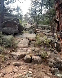
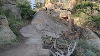
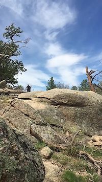
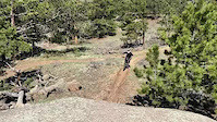
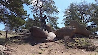
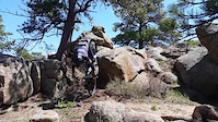
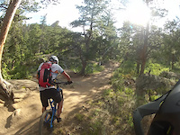
Photos of Cheyenne Mountain Bike
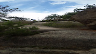
Videos of Cheyenne Mountain Bike
trail: Broke Bike Mountain
0:05 |
|
Jul 1, 2024
trail: Gold Rush
0:13 |
251 |
Aug 10, 2022
trail: El Alto
0:44 |
263 |
May 29, 2021
trail: El Alto
0:10 |
191 |
May 29, 2021
trail: 2 Percent
0:09 |
276 |
May 23, 2021
trail: 2 Percent
0:07 |
204 |
May 23, 2021
trail: Huck Fins
0:12 |
484 |
May 23, 2021
trail: Pinball
0:29 |
225 |
Nov 18, 2020
Recent Trail Reports
| status | trail | date | condition | info | user |
|---|---|---|---|---|---|
| Rock N' V | May 20, 2026 @ 3:14pm (America/Denver) May 20, 2026 | Variable | huhmanj | ||
| Rock N Roller | May 20, 2026 @ 3:14pm (America/Denver) May 20, 2026 | Variable | huhmanj | ||
| Albert's Alley | May 20, 2026 @ 3:14pm (America/Denver) May 20, 2026 | Variable | huhmanj | ||
| Elevator Shaft | May 20, 2026 @ 3:14pm (America/Denver) May 20, 2026 | Variable | huhmanj | ||
| Suture Line | May 20, 2026 @ 3:14pm (America/Denver) May 20, 2026 | Variable | huhmanj | ||
| Mo Rocka | May 20, 2026 @ 3:14pm (America/Denver) May 20, 2026 | Variable | huhmanj | ||
| Crow Creek (E) | May 20, 2026 @ 3:14pm (America/Denver) May 20, 2026 | Variable | huhmanj | ||
| Pinball | May 20, 2026 @ 3:14pm (America/Denver) May 20, 2026 | Variable | huhmanj | ||
| Aspen Alley | May 20, 2026 @ 3:14pm (America/Denver) May 20, 2026 | Wet | huhmanj | ||
| Kate's Trail | May 20, 2026 @ 3:14pm (America/Denver) May 20, 2026 | Variable | huhmanj |
Activity Feed
| username | action | type | title | date |
|---|---|---|---|---|
| lug-wrench | wishlist | route | activity #97311594 | Jun 19, 2026 @ 6:09am 4 hours |
| lesschwab | wishlist | trail | activity #96690819 | Jun 10, 2026 @ 12:45pm Jun 10, 2026 |
| eTQldH | wishlist | trail | activity #96627979 | Jun 9, 2026 @ 1:55pm Jun 9, 2026 |
| Rteckard | ridden | trail | activity #96584246 and 1 more | Jun 8, 2026 @ 9:20pm Jun 8, 2026 |
| nadiaalmuti | vote | trail | activity #96542920 and 5 more | Jun 8, 2026 @ 8:56am Jun 8, 2026 |
Recent Comments
| username | type | title | comment | date |
|---|---|---|---|---|
| trail | This trail is sick! Slab rock roller all the... | May 16, 2026 @ 9:43pm May 16, 2026 | ||
| trail | Fabulous trail! First time riding at Gowdy,... | Apr 8, 2026 @ 9:17am Apr 8, 2026 | ||
| trail | Long and technical. It’ll challenge you in... | Nov 18, 2025 @ 3:17pm Nov 18, 2025 | ||
| trail | Another trail that will not disappoint you.... | Nov 18, 2025 @ 3:16pm Nov 18, 2025 | ||
| trail | Another trail that won’t disappoint you... | Nov 18, 2025 @ 3:15pm Nov 18, 2025 |
Local Badges
-

10 Expert Trails47 awarded -

Descent 100k Badge1 awarded -

Big Ride 30k310 awarded -

Epic Ride 50k83 awarded -

Descent 10k Badge26 awarded -

Top 10 Trails10 awarded
Bike & Skill Parks
| name | type | city | rating |
|---|---|---|---|
| Curt Gowdy Skills Park | skill park | Cheyenne | |
| Laramie County Motocross | skill park | Cheyenne |
Activity Type Stats
| activitytype | trails | distance | descent | descent distance | total vertical | rating | global rank | state rank | photos | reports | routes | ridelogs |
|---|---|---|---|---|---|---|---|---|---|---|---|---|
| Mountain Bike | 82 | 57 miles | 9,800 ft | 23 miles | 1,726 ft | #1,421 | #539 | 330 | 1,669 | 15 | 9,737 | |
| E-Bike | 63 | 43 miles | 9,501 ft | 20 miles | 892 ft | #2,698 | #1,056 | 3 | 1,568 | 6 | 369 | |
| Horse | 4 | 4 miles | 531 ft | 2 miles | 407 ft | #2,168 | #1,207 | 521 | 1 | |||
| Hike | 81 | 57 miles | 9,800 ft | 23 miles | 1,726 ft | #3,626 | #1,276 | 1 | 1,663 | 399 | ||
| Trail Running | 81 | 57 miles | 9,800 ft | 23 miles | 1,726 ft | #3,083 | #898 | 1,663 | 410 |
Frequently Asked Questions About Cheyenne
▼
What are the best places to ride in Cheyenne?
Cheyenne has 2 areas to explore for mountain biking. The top rated areas are:
▼
What are the highest rated mountain biking trails in Cheyenne?
The highest rated mountain biking trails in Cheyenne are:
- Gold Rush (4.5/5)
- Gold Watch (4.5/5)
- Gold Standard (4.4/5)
- Gold Digger (4.4/5)
- Stone Temple Circuit (4.4/5)
▼
What is the best time of the year to ride in Cheyenne?
Based on ride log data, the most popular months to ride in Cheyenne are:
- July (95 activities)
- August (86 activities)
- June (75 activities)
▼
Where can I park to ride in Cheyenne?
There are 14 parking locations listed in Cheyenne. The most popular parking spots are: View all parking and trailhead locations on the map to plan your visit.
Activities
Trails
Points of Interest
- Curt Gowdy Visitors Center Information
- Fee Booth Information
- Rock Face TTF
- North Causeway Campground Camping
- Happy Jack Campground Camping
- Silver Crown Campground Camping
- Tumbleweeds Campground Camping
- Hecla Point Campground Camping
- Federal Bay Campground Camping
- Twin Lakes Creek Campground Camping
- Mesa Mountain (7,605 ft)
- Table Mountain (7,552 ft)
- Eagle Hill (6,542 ft)
- By brenthillier
 NSMBA TRAILFORKS & contributors
 - Admins: WP, chuktA, BIKENET, 30percentirish
- #8658 - 6,769 views
- cheyenne activity log | embed map of Cheyenne mountain bike trails | cheyenne mountain biking points of interest
Downloading of trail gps tracks in kml & gpx formats is enabled for Cheyenne.
You must login to download files.