close
-
Layers w
- Weather Layers
- Pro
- Pro
- Pro
- Pro
- Pro
- Pro
- More Layers
- Pro
- Pro
- Pro
- Pro
-
Upgrade to

3D
Trail Conditions
- Unknown
- Snow Groomed
- Snow Packed
- Snow Covered
- Snow Cover Partial
- Freeze/thaw Cycle
- Icy
- Prevalent Mud
- Wet
- Variable
- Ideal
- Dry
- Very Dry
Trail Flow (Ridden Direction)
Trailforks scans users ridelogs to determine the most popular direction each trail is ridden. A good flowing trail network will have most trails flowing in a single direction according to their intension.
The colour categories are based on what percentage of riders are riding a trail in its intended direction.
The colour categories are based on what percentage of riders are riding a trail in its intended direction.
- > 96%
- > 90%
- > 80%
- > 70%
- > 50%
- < 50%
- bi-directional trail
- no data
Trail Last Ridden
Trailforks scans ridelogs to determine the last time a trail was ridden.
- < 2 days
- < 1 week
- < 2 weeks
- < 1 month
- < 6 months
- > 6 months
Trail Ridden Direction
The intended direction a trail should be ridden.
- Downhill Only
- Downhill Primary
- Both Directions
- Uphill Primary
- Uphill Only
- One Direction
Contribute Details
Colors indicate trail is missing specified detail.
- Description
- Photos
- Description & Photos
- Videos
Trail Popularity ?
Trailforks scans ridelogs to determine which trails are ridden the most in the last 9 months.
Trails are compared with nearby trails in the same city region with a possible 25 colour shades.
Think of this as a heatmap, more rides = more kinetic energy = warmer colors.
- most popular
- popular
- less popular
- not popular
ATV/ORV/OHV Filter
Max Vehicle Width
inches
US Cell Coverage
Legend

Radar Time
Activity Recordings
Trailforks uses anonymized public activity data.
?
Activity Recordings
Trailforks uses anonymized public activity data.
?
Personal Heatmap
▶
Activity Types
all
/
none
▶
Options
2
Date range
month
–
Winter Trails
Warning
A routing network for winter maps does not exist. Selecting trails using the winter trails layer has been disabled.
Missing Trails
Most Popular
Least Popular
Trails are colored based on popularity. The more popular a trail is, the more red. Less popular trails trend towards green.
Jump Magnitude Heatmap
Heatmap of where riders jump on trails. Zoom in to see individual jumps, click circles to view jump details.
BC Backroad Status
![map legend]()
Service Road Atlas is a free to use, community-driven service for viewing and creating reports on the numerous back-country service roads around B.C. and Alberta.

Slope Aspect
Direction the slope faces
Trails Deemphasized
Trails are shown in grey.
Only show trails with no bike usage.
Suggested Layers
Based on selected activity type
Save the current map location and zoom level as your default home location whenever this page is loaded.
Save
No description for Chicago has been added yet!
Login or register to submit one.
Activities Click to view
- Mountain Bike
201 trails
- E-Bike
195 trails
- Adaptive Bike
0 trails
- Horse
35 trails
- Hike
216 trails
- Trail Running
206 trails
- Nordic Ski
62 trails
Region Details
- 168
- 20
- 5
- 3
- 1
- 1
Region Status
Open as of Jun 3, 2026Stats
- Avg Trail Rating
- Trails (view details)
- 236
- Trails Mountain Bike
- 201
- Trails E-Bike
- 195
- Trails Horse
- 35
- Trails Hike
- 216
- Trails Trail Running
- 206
- Trails Nordic Ski
- 62
- Total Distance
- 86 miles
- Total Descent
- 776 ft
- Total Vertical
- 91 ft
- Highest Trailhead
- 666 ft
- Reports
- 75
- Photos
- 24
- Ridden Counter
- 13,057
Sub Regions
-
Big Marsh Bike Park
- 4
- 3
- 1
-
Burnham Park
-
Catherine Chevalier Woods
-
Chicago Lakefront Trails
- 20
-
Dan Ryan Woods
-
Eggers Grove - Wolf Lake Overlook
-
Fullerton - River Grove Preserves
-
Northerly Island Park
-
Robinson Woods
-
Schiller Woods
-
The Garden Dirt Jumps & Bike Park
- 1
- 1
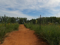
Popular Chicago Mountain Biking Trails
• 100 ★ 4.0 • 1,414 ft • 3 ft • 405 •
Popular white difficulty paved path. This multi-use trail can be used both directions and has a easy overall physical rating with a 3 ft green climb. Trail visibility is always easy to follow. On average it takes 1 minutes to complete this trail.
• 100 ★ 5.0 • 2 miles • 28 ft • 365 •
Popular white difficulty paved path. This multi-use trail can be used both directions and has a easy overall physical rating with a 28 ft green climb. Trail visibility is always easy to follow. On average it takes 6 minutes to complete this trail.
• 100 ★ 0.0 • 2 miles • 39 ft • 292 •
Popular white difficulty paved path. This multi-use trail can be used both directions and has a easy overall physical rating. Trail visibility is always easy to follow. On average it takes 8 minutes to complete this trail.
• 95 ★ 0.0 • 2 miles • 32 ft • 203 •
Popular white difficulty paved path. This multi-use trail can be used both directions and has a easy overall physical rating with a 32 ft green climb. Trail visibility is always easy to follow. On average it takes 7 minutes to complete this trail.
• 100 ★ 0.0 • 482 ft • 0 ft • 200 •
Popular white difficulty paved path. This multi-use trail can be used both directions and has a easy overall physical rating with a 0 ft green climb. Trail visibility is always easy to follow. On average it takes 1 minutes to complete this trail.
• 95 ★ 4.0 • 1,460 ft • 14 ft • 171 •
Popular white difficulty paved path. This multi-use trail can be used both directions and has a easy overall physical rating with a 14 ft green climb. Trail visibility is always easy to follow. On average it takes 6 minutes to complete this trail.
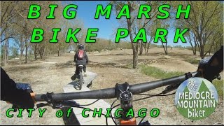
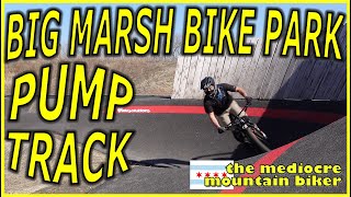
Videos of Chicago Mountain Bike
trail: Small Jump Line
0:21 |
54 |
Oct 18, 2023

trail: Large Jump Line
0:34 |
188 |
Jun 13, 2023

2:51 |
19485 |
Nov 5, 2014
youtuber
![I devoted a year to XC RACING & the...]()

trail: Front Loop
27:42 |
184 |
Jan 20, 2024 , Chicago
youtuber
![Big Marsh Bike Park with my son]()
8:15 |
151 |
Oct 15, 2023
youtuber
![Big Marsh Bike Park - Velosolutions Pump Track!]()
9:58 |
179 |
Oct 15, 2023

4:22 |
239 |
Jul 28, 2022
youtuber
![Big Pump Track at Big Marsh: Big MTB Possibilities]()

4:34 |
450 |
Feb 1, 2021
Recent Trail Reports
| status | trail | date | condition | info | user |
|---|---|---|---|---|---|
| Lakefront Trail Shared Use | Jul 12, 2025 @ 12:52pm Jul 12, 2025 | Ideal | bneffer | ||
| Lakefront Trail Connector | Jul 13, 2025 @ 9:33am Jul 13, 2025 | Ideal | bneffer | ||
| Lakefront Trail Connector | Jul 12, 2025 @ 7:37pm Jul 12, 2025 | Ideal | bneffer | ||
| Lakefront Trail Shared Use | Jul 12, 2025 @ 7:37pm Jul 12, 2025 | Ideal | bneffer | ||
| Lakefront Trail Bike | Jul 12, 2025 @ 7:37pm Jul 12, 2025 | Ideal | bneffer | ||
| Lakefront Trail Connector | Jul 12, 2025 @ 7:37pm Jul 12, 2025 | Ideal | bneffer | ||
| Lakefront Trail Beach Connector | Jan 23, 2025 @ 4:59pm Jan 23, 2025 | Variable | turtle5 | ||
| Des Plaines River Trail | Sep 14, 2024 @ 11:20am Sep 14, 2024 | Dry | evan-b | ||
| Des Plaines River Trail | Apr 14, 2024 @ 5:00am Apr 14, 2024 | Ideal | kapitantropikal | ||
| Des Plaines River Trail Connector | Apr 14, 2024 @ 5:00am Apr 14, 2024 | Ideal | kapitantropikal |
Activity Feed
| username | action | type | title | date |
|---|---|---|---|---|
| MinnesotaTopps | wishlist | trail | activity #96471639 | Jun 7, 2026 @ 9:42am Jun 7, 2026 |
| c0ff33st41n | wishlist | region | activity #95140193 | May 20, 2026 @ 4:32pm May 20, 2026 |
| BobbySends143 | vote | trail | activity #93456010 | Apr 26, 2026 @ 10:13am Apr 26, 2026 |
| Borisfnp2io | wishlist | trail | activity #91743763 | Apr 1, 2026 @ 9:22pm Apr 1, 2026 |
| Borisfnp2io | wishlist | trail | activity #91743724 | Apr 1, 2026 @ 9:20pm Apr 1, 2026 |
Recent Comments
| username | type | title | comment | date |
|---|---|---|---|---|
| trail | Why is this a Proline | Jul 18, 2023 @ 4:09pm Jul 18, 2023 |
Local Badges
-

Epic Mountain Bike Climb 2k0 awarded -

Climbing 10k Badge6 awarded -

Mountain Biking 100k Badge0 awarded -

Epic Ride Descent 2k0 awarded -

Descent 10k Badge6 awarded -

Descent 100k Badge0 awarded
Bike & Skill Parks
| name | type | city | rating |
|---|---|---|---|
| The Garden Dirt Jumps | skill park | Chicago | |
| Big Marsh Pump Track | skill park | Chicago |
Activity Type Stats
| activitytype | trails | distance | descent | descent distance | total vertical | rating | global rank | state rank | photos | reports | routes | ridelogs |
|---|---|---|---|---|---|---|---|---|---|---|---|---|
| Mountain Bike | 201 | 62 miles | 541 ft | 9 miles | 92 ft | #1,614 | #608 | 16 | 75 | 24,151 | ||
| E-Bike | 195 | 76 miles | 722 ft | 12 miles | 92 ft | #1,372 | #857 | 74 | 618 | |||
| Horse | 35 | 11 miles | 95 ft | 2 miles | 36 ft | #1,625 | #933 | 1 | ||||
| Hike | 216 | 67 miles | 574 ft | 10 miles | 92 ft | #2,022 | #857 | 74 | 495 | |||
| Trail Running | 206 | 65 miles | 574 ft | 10 miles | 92 ft | #1,406 | #501 | 74 | 3,337 | |||
| Nordic Ski | 62 | 16 miles | 118 ft | 3 miles | 59 ft | #688 | #246 | 16 |
Frequently Asked Questions About Chicago
▼
What are the best places to ride in Chicago?
Chicago has 12 areas to explore for mountain biking. The top rated areas are:
▼
What are the highest rated mountain biking trails in Chicago?
The highest rated mountain biking trails in Chicago are:
- Big Marsh Pump Track West (4.2/5)
- Big Marsh Pump Track East (4.2/5)
- Medium Jump Line (4.1/5)
- Lakefront Trail Bike (4.1/5)
- Lakefront Trail Shared Use (4/5)
▼
What is the best time of the year to ride in Chicago?
Based on ride log data, the most popular months to ride in Chicago are:
- July (45 activities)
- June (39 activities)
- September (35 activities)
▼
Where can I park to ride in Chicago?
There are 45 parking locations listed in Chicago. The most popular parking spots are: View all parking and trailhead locations on the map to plan your visit.
Activities
Trails
Points of Interest
- Schiller Woods Grove 10 Picnic Shelter Cabin
- Catherine Chevalier Woods Grove 1 Picnic Shelter Cabin
- Catherine Chevalier Woods Grove 2 Picnic Shelter Cabin
- Catherine Chevalier Woods Grove 3 Picnic Shelter Cabin
- Robinson Woods Grove 1 Picnic Shelter Cabin
- Robinson Woods Grove 2 Picnic Shelter Cabin
- [Canoe/Kayak Launch] Other
- Schiller Woods Grove 2 Picnic Shelter Cabin
- Schiller Woods Grove 4 Picnic Shelter Cabin
- Schiller Woods Grove 9 Picnic Shelter Cabin
- By andrewsigala
 & contributors
 - Admins: CAMBR, FPDCC
- #6729 - 11,810 views
- chicago activity log | embed map of Chicago mountain bike trails | chicago mountain biking points of interest
Downloading of trail gps tracks in kml & gpx formats is enabled for Chicago.
You must login to download files.