close
-
Layers w
- Weather Layers
- Pro
- Pro
- Pro
- Pro
- Pro
- Pro
- More Layers
- Pro
- Pro
- Pro
- Pro
-
Upgrade to

3D
Trail Conditions
- Unknown
- Snow Groomed
- Snow Packed
- Snow Covered
- Snow Cover Partial
- Freeze/thaw Cycle
- Icy
- Prevalent Mud
- Wet
- Variable
- Ideal
- Dry
- Very Dry
Trail Flow (Ridden Direction)
Trailforks scans users ridelogs to determine the most popular direction each trail is ridden. A good flowing trail network will have most trails flowing in a single direction according to their intension.
The colour categories are based on what percentage of riders are riding a trail in its intended direction.
The colour categories are based on what percentage of riders are riding a trail in its intended direction.
- > 96%
- > 90%
- > 80%
- > 70%
- > 50%
- < 50%
- bi-directional trail
- no data
Trail Last Ridden
Trailforks scans ridelogs to determine the last time a trail was ridden.
- < 2 days
- < 1 week
- < 2 weeks
- < 1 month
- < 6 months
- > 6 months
Trail Ridden Direction
The intended direction a trail should be ridden.
- Downhill Only
- Downhill Primary
- Both Directions
- Uphill Primary
- Uphill Only
- One Direction
Contribute Details
Colors indicate trail is missing specified detail.
- Description
- Photos
- Description & Photos
- Videos
Trail Popularity ?
Trailforks scans ridelogs to determine which trails are ridden the most in the last 9 months.
Trails are compared with nearby trails in the same city region with a possible 25 colour shades.
Think of this as a heatmap, more rides = more kinetic energy = warmer colors.
- most popular
- popular
- less popular
- not popular
ATV/ORV/OHV Filter
Max Vehicle Width
inches
US Cell Coverage
Legend

Radar Time
Activity Recordings
Trailforks uses anonymized public activity data.
?
Activity Recordings
Trailforks uses anonymized public activity data.
?
Personal Heatmap
▶
Activity Types
all
/
none
▶
Options
2
Date range
month
–
Winter Trails
Warning
A routing network for winter maps does not exist. Selecting trails using the winter trails layer has been disabled.
Missing Trails
Most Popular
Least Popular
Trails are colored based on popularity. The more popular a trail is, the more red. Less popular trails trend towards green.
Jump Magnitude Heatmap
Heatmap of where riders jump on trails. Zoom in to see individual jumps, click circles to view jump details.
BC Backroad Status
![map legend]()
Service Road Atlas is a free to use, community-driven service for viewing and creating reports on the numerous back-country service roads around B.C. and Alberta.

Slope Aspect
Direction the slope faces
Trails Deemphasized
Trails are shown in grey.
Only show trails with no bike usage.
Suggested Layers
Based on selected activity type
Save the current map location and zoom level as your default home location whenever this page is loaded.
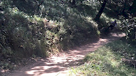
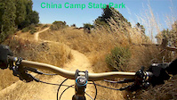
SaveChina Camp State Park is a great area for beginner singletrack. It is located in the heart of Marin County and a very popular destination for mountain bikers and hikers alike. Great camping facilities on site as well. There is a $3 trail use fee per day now as well, there is a kiosk at the trail head. If you explore the "backside" of China Camp, you will find trails suited to more advanced riders.
Primary Trail Type: Cross-Country
Land Status: State Park
Land Manager: California State Parks
 google parking directions
 Access Info:
San Pablo Exit off the 101, just look for China Camp State Park signs.
Links
Activities Click to view
- Mountain Bike
19 trails
- E-Bike
7 trails
- Horse
9 trails
- Hike
19 trails
- Trail Running
19 trails
Region Details
- 6
- 6
- 1
- 2
Region Status
Open as of 2 daysStats
- Avg Trail Rating
- Trails (view details)
- 17
- Trails Mountain Bike
- 19
- Trails E-Bike
- 7
- Trails Horse
- 9
- Trails Hike
- 19
- Trails Trail Running
- 19
- Total Distance
- 20 miles
- Total Descent
- 5,355 ft
- Total Vertical
- 1,024 ft
- Highest Trailhead
- 1,032 ft
- Reports
- 589
- Photos
- 84
- Ridden Counter
- 21,636
Popular China Camp Mountain Biking Trails
• 100 ★ 4.0 • 2 miles • 325 ft • 2,503 •
Popular green difficulty singletrack. This multi-use trail can be used both directions and has a moderate overall physical rating with a 325 ft blue climb. On average it takes 16 minutes to complete this trail.
• 100 ★ 3.7 • 3 miles • 630 ft • 2,033 •
Very fun, good grip, all riders can do that, I recommend this trail a lot!
• 100 ★ 3.5 • 2,908 ft • 100 ft • 1,604 •
Popular green difficulty singletrack. This multi-use trail can be used both directions. On average it takes 7 minutes to complete this trail.
• 80 ★ 4.3 • 1 mile • 44 ft • 557 • • hike
A nice technical trail for the area and definitely one of the better rides around here. It’s well-groomed, and there are plenty of spots to duck out if you only want to ride one or two sections. The upper part of the trail is more...
• 60 ★ 3.0 • 5 miles • 299 ft • 519 •
This is a great beginner singletrack. It is located in the heart of Marin County and a very popular destination for mountain bikers and hikers alike. Great camping facilities on site as well. There is a $3 trail use fee per day now as...
• 40 ★ 3.0 • 131 ft • 0 ft • 69 • • hike
Moderately popular green difficulty singletrack. This hike primary trail can be used both directions. On average it takes minutes to complete this trail.
• 15 ★ 0.0 • 3,488 ft • 38 ft • 6 • • hike
Less popular green difficulty singletrack. This hike primary trail can be used both directions. On average it takes 9 minutes to complete this trail.
China Camp Mountain Bike Routes
★ 4.3 • 13 miles • 1,878 ft • 4 • Loop •
This is a longer China Camp SP route that drops into the backside (aka the Darkside) after peaking at the...
★ 5.0 • 9 miles • 961 ft • 3 • Loop •
Beginner mountain biking loop around the 2 green and most common mountain bike trails at China Camp State Park
★ 3.5 • 13 miles • 1,875 ft • 16 •
Longer route in china camp to catch some of the blue trails
19 miles • 2,820 ft • 13 • Loop •
Figure eight loop within (Eastside) and outside of (Westside) boundaries of China Camp State Park....
• 21 miles • 4,136 ft • 8 •
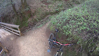
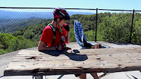
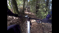
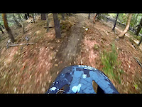
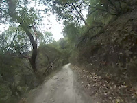
Photos of China Camp Mountain Bike
Videos of China Camp Mountain Bike
trail: Bay View Trail
0:11 |
610 |
Jun 14, 2016
trail: Bay View Trail
2:38 |
687 |
Jul 26, 2015

trail: 7 Eleven Trail
3:30 |
109 |
Feb 21, 2015
trail: Bay View Trail
3:43 |
530 |
Feb 14, 2015
trail: Shoreline Trail
3:26 |
802 |
Jan 19, 2014
trail: Back Ranch Fire Trail
4:16 |
247 |
Dec 8, 2013
trail: Back Ranch Fire Trail
2:48 |
249 |
Sep 30, 2013
trail: Shoreline Trail
5:24 |
470 |
Sep 5, 2013
Recent Trail Reports
| status | trail | date | condition | info | user |
|---|---|---|---|---|---|
| 7 Eleven Trail | Jun 17, 2026 @ 2:51pm (America/Los_Angeles) 2 days | Very Dry | awaite | ||
| Echo | Jun 17, 2026 @ 2:51pm (America/Los_Angeles) 2 days | Very Dry | awaite | ||
| Oak Ridge | May 17, 2026 @ 1:11pm (America/Los_Angeles) May 17, 2026 | Dry | spamajama | ||
| Bay View Trail | May 17, 2026 @ 1:11pm (America/Los_Angeles) May 17, 2026 | Dry | spamajama | ||
| Powerline Fire | May 17, 2026 @ 1:11pm (America/Los_Angeles) May 17, 2026 | Ideal | spamajama | ||
| Reach Around | Feb 21, 2026 @ 1:07pm (America/Los_Angeles) Feb 21, 2026 | Ideal | awaite | ||
| Bay Hills Fire Rd. | Nov 22, 2025 @ 3:52pm (America/Los_Angeles) Nov 22, 2025 | Ideal | chriscrisp | ||
| Bay Hills Drive | Oct 4, 2025 @ 10:37am (America/Los_Angeles) Oct 4, 2025 | Dry | NIwxJ | ||
| Shoreline Trail | Jun 22, 2025 @ 2:16pm Jun 22, 2025 | Dry | dfsnow | ||
| Bullet Hill Trail | Oct 14, 2024 @ 1:19pm Oct 14, 2024 | Very Dry | Fjr17 |
Activity Feed
| username | action | type | title | date |
|---|---|---|---|---|
| awaite | add | report | activity #97220146 and 1 more | Jun 17, 2026 @ 5:27pm 2 days |
| varchard | wishlist | trail | activity #96406574 | Jun 6, 2026 @ 2:28pm Jun 6, 2026 |
| LoganO9JRew | wishlist | route | activity #96270845 | Jun 4, 2026 @ 7:17pm Jun 4, 2026 |
| clzcyclone | wishlist | region | activity #95958886 | May 31, 2026 @ 10:59am May 31, 2026 |
| ChrisMatthewsXR | wishlist | route | activity #95842328 | May 30, 2026 @ 5:43am May 30, 2026 |
Recent Comments
| username | type | title | comment | date |
|---|---|---|---|---|
| trail | Definitely a green . I brought my son out here... | Apr 12, 2026 @ 10:25am Apr 12, 2026 | ||
| trail | IDK…awfully hard not to call this a green... | Oct 4, 2025 @ 4:12pm Oct 4, 2025 | ||
| trail | Heavily sanitized since I last rode this... | May 26, 2025 @ 9:27pm May 26, 2025 | ||
| trail | bottom half is an easy fire road, but top half... | Dec 1, 2024 @ 8:24am Dec 1, 2024 | ||
| trail | Connector between Bay View and Bay hills... | Apr 19, 2024 @ 11:55pm Apr 19, 2024 |
Nearby Areas
| name | distance | ||||
|---|---|---|---|---|---|
| Harry A Barbier Memorial Park | 9 | 6 | 0.8 km | ||
| Hamilton Field | 2 | 2.1 km | |||
| The Graveyard | 2 | 4.1 km | |||
| Terra Linda / Sleepy Hollow Preserve | 5 | 4.3 km | |||
| Bald Hill | 1 | 5.2 km |
Local Products
Activity Type Stats
| activitytype | trails | distance | descent | descent distance | total vertical | rating | global rank | state rank | photos | reports | routes | ridelogs |
|---|---|---|---|---|---|---|---|---|---|---|---|---|
| Mountain Bike | 19 | 19 miles | 3,753 ft | 8 miles | 1,024 ft | #3,055 | #1,060 | 84 | 588 | 5 | 29,945 | |
| E-Bike | 7 | 13 miles | 945 ft | 4 miles | 971 ft | #4,440 | #1,236 | 547 | 1 | 2,060 | ||
| Horse | 9 | 16 miles | 2,070 ft | 6 miles | 1,017 ft | #1,422 | #722 | 132 | 1 | |||
| Hike | 19 | 20 miles | 4,865 ft | 9 miles | 1,024 ft | #1,348 | #639 | 588 | 539 | |||
| Trail Running | 19 | 20 miles | 4,865 ft | 9 miles | 1,024 ft | #6,734 | #2,180 | 588 | 417 |
Frequently Asked Questions About China Camp
▼
What are the highest rated mountain biking trails in China Camp?
The highest rated mountain biking trails in China Camp are:
- 7 Eleven Trail (4.1/5)
- Oak Ridge (3.9/5)
- Turtle Back Trail (3.8/5)
- Bay View Trail (3.8/5)
- Echo (3.7/5)
▼
What is the best time of the year to ride in China Camp?
Based on ride log data, the most popular months to ride in China Camp are:
- July (238 activities)
- October (174 activities)
- August (166 activities)
▼
Where can I park to ride in China Camp?
There are 5 parking locations listed in China Camp. The most popular parking spots are: View all parking and trailhead locations on the map to plan your visit.
▼
What is the longest trail in China Camp?
The longest trail in China Camp is Shoreline Trail at 8.2 km. View all trails sorted by distance.
Activities
Trails
Points of Interest
- By brenthillier
 NSMBA TRAILFORKS & contributors
 - Admins: A4B, A4B
- #3976 - 53,519 views
- china camp activity log | embed map of China Camp mountain bike trails | china camp mountain biking points of interest polygons
Downloading of trail gps tracks in kml & gpx formats is enabled for China Camp.
You must login to download files.