close
-
Layers w
- Weather Layers
- Pro
- Pro
- Pro
- Pro
- Pro
- Pro
- More Layers
- Pro
- Pro
- Pro
- Pro
-
Upgrade to

3D
Trail Conditions
- Unknown
- Snow Groomed
- Snow Packed
- Snow Covered
- Snow Cover Partial
- Freeze/thaw Cycle
- Icy
- Prevalent Mud
- Wet
- Variable
- Ideal
- Dry
- Very Dry
Trail Flow (Ridden Direction)
Trailforks scans users ridelogs to determine the most popular direction each trail is ridden. A good flowing trail network will have most trails flowing in a single direction according to their intension.
The colour categories are based on what percentage of riders are riding a trail in its intended direction.
The colour categories are based on what percentage of riders are riding a trail in its intended direction.
- > 96%
- > 90%
- > 80%
- > 70%
- > 50%
- < 50%
- bi-directional trail
- no data
Trail Last Ridden
Trailforks scans ridelogs to determine the last time a trail was ridden.
- < 2 days
- < 1 week
- < 2 weeks
- < 1 month
- < 6 months
- > 6 months
Trail Ridden Direction
The intended direction a trail should be ridden.
- Downhill Only
- Downhill Primary
- Both Directions
- Uphill Primary
- Uphill Only
- One Direction
Contribute Details
Colors indicate trail is missing specified detail.
- Description
- Photos
- Description & Photos
- Videos
Trail Popularity ?
Trailforks scans ridelogs to determine which trails are ridden the most in the last 9 months.
Trails are compared with nearby trails in the same city region with a possible 25 colour shades.
Think of this as a heatmap, more rides = more kinetic energy = warmer colors.
- most popular
- popular
- less popular
- not popular
ATV/ORV/OHV Filter
Max Vehicle Width
inches
US Cell Coverage
Legend

Radar Time
Activity Recordings
Trailforks uses anonymized public activity data.
?
Activity Recordings
Trailforks uses anonymized public activity data.
?
Personal Heatmap
▶
Activity Types
all
/
none
▶
Options
2
Date range
month
–
Winter Trails
Warning
A routing network for winter maps does not exist. Selecting trails using the winter trails layer has been disabled.
Missing Trails
Most Popular
Least Popular
Trails are colored based on popularity. The more popular a trail is, the more red. Less popular trails trend towards green.
Jump Magnitude Heatmap
Heatmap of where riders jump on trails. Zoom in to see individual jumps, click circles to view jump details.
BC Backroad Status
![map legend]()
Service Road Atlas is a free to use, community-driven service for viewing and creating reports on the numerous back-country service roads around B.C. and Alberta.

Slope Aspect
Direction the slope faces
Trails Deemphasized
Trails are shown in grey.
Only show trails with no bike usage.
Suggested Layers
Based on selected activity type
Save the current map location and zoom level as your default home location whenever this page is loaded.
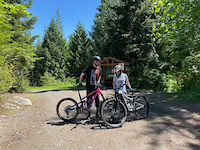
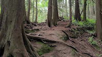
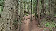
SaveThe Chuckanut Mountains are some of the most scenic trails in our area. Rising straight out of the ocean, the mountains boast a massive amount of old growth forests with some of the best views around. The trails wind in and out of Larrabee state park and are primarily hiking trails that allow mountain biking on designated trails. The trails offer a massive amount of vertical for those not afraid to climb along with great views and extremely high quality flowy singletrack.
Primary Trail Type: All-Mountain & Downhill
eBikes Allowed:
Yes
Shuttleable: YES
AKA: The Chuckanuts
Land Status: State Forest
 google parking directions
 Access Info:
There are three main ways to access the Chuckanut mountains, the Arroyo Park entrance, Cleator Road and Fragrance Lake Road. All the access points are off of Chuckanut Drive. The Arroyo Park has a parking lot right off of Chuckanut Drive next to California St. Cleator road goes all the way to a view point where you can access trails in the Larrabee State park. The Fragrance Lake Road access is via the Clayton Beach Parking lot just south of Larrabee State Park.
Activities Click to view
- Mountain Bike
46 trails
- E-Bike
33 trails
- Horse
5 trails
- Hike
47 trails
- Trail Running
48 trails
- Dirtbike/Moto
3 trails
Region Details
- 14
- 10
- 13
- 8
Region Status
Open as of Jun 12, 2026Local Trail Association
Stats
- Avg Trail Rating
- Trails (view details)
- 47
- Trails Mountain Bike
- 46
- Trails E-Bike
- 33
- Trails Horse
- 5
- Trails Hike
- 47
- Trails Trail Running
- 48
- Trails Dirtbike/Moto
- 3
- Total Distance
- 50 miles
- Total Descent
- 11,884 ft
- Total Vertical
- 1,918 ft
- Highest Trailhead
- 1,918 ft
- Reports
- 1,212
- Photos
- 671
- Ridden Counter
- 33,094
Popular Chuckanut Mountain Mountain Biking Trails
• 90 ★ 4.8 • 4,551 ft • 0 ft • 3,648 •
Continue off double black to the bottom of the mountain. This is a twisty and technical trail with roots and a few natural rock drops. There's a portion with mild ravine exposure. It's a lot of fun for the adventurous rider seeking some...
• 85 ★ 4.8 • 1 mile • 0 ft • 3,226 •
Steep downhill trail with lots of roots, and a few rock faces. Good dirt, pretty natural trail, no built berms or jumps. Two short climbs on the trail.
• 85 ★ 3.6 • 456 ft • 53 ft • 2,822 •
Walk up to the top of Chuckanut. Double Black (right) and upper Ridge (left) start at the top. Bonus points if you ride it.
• 70 ★ 4.3 • 1,020 ft • 0 ft • 1,222 •
Highly rated popular blue difficulty singletrack. This mountain bike primary trail can be used downhill primary. On average it takes 4 minutes to complete this trail.
• 80 ★ 3.0 • 758 ft • 76 ft • 1,098 •
This trail has a couple wood bridges and can get slippery in the wet. A good way to get up to the Interurban from the north parking lot.
• 60 ★ 4.2 • 1 mile • 10 ft • 787 •
This is a challenging trail, full of tight corners and peppered with roots this will challenge even the best riders. Most take this as a down hill route but it can be either direction. This trail has been apart of the local Enduro race...
• 60 ★ 2.9 • 2 miles • 0 ft • 738 •
Lower trail section is flowy and fun riding through the trees. It's a nice climb and a nice descent.nnThe upper section is really just a steep fire road. You'll be sad losing all that hard won altitude on the upper section if that's...
• 50 ★ 4.1 • 1,165 ft • 9 ft • 731 •
Exit trail from upper ridge down to , fast and fun. Classic Chuckanut roots and rock with a steeper and more consistent grade than the , you want to exit here most likely as the middle section of the has numerous hike-a-bikes.
Chuckanut Mountain Mountain Bike Routes
★ 3.5 • 6 miles • 1,773 ft • 15 • Loop •
The classic Chuckanut short loop,Double Black and is an amazing pair of trails if you like going fast....
9 miles • 1,772 ft • 6 • Loop •
After many tries - I think this is the best most rideable route in the North Chuckanuts. Hard uphill, yes,...
6 miles • 1,374 ft • 1 • Point to Point •
This route is a nice way to experience the north end of Chuckanut Mountain in just one ride. I recommended...
★ 2.0 • 15 miles • 3,138 ft • 7 • Loop •
Cross country/enduro route in the Chuckanuts that ends by dropping double black/double down.
13 miles • 2,196 ft • 26 • Loop •
Here's a route which will offer a flavour of the Chuckanuts whilst staying away from the black diamonds....
★ 1.0 • 13 miles • 1,910 ft • 15 • Loop •
start at arroyo, warm up on interurban, climb Cleator Rd, descend double black and double down, return to...
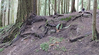
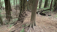
Photos of Chuckanut Mountain Mountain Bike
Videos of Chuckanut Mountain Mountain Bike

trail: Upper Chuckanut Ridge
0:15 |
25 |
Jun 25, 2023
trail: Upper Chuckanut Ridge
0:05 |
26 |
Jun 25, 2023
trail: Upper Chuckanut Ridge
0:13 |
30 |
Jun 25, 2023
trail: Upper Chuckanut Ridge
0:42 |
23 |
Jun 25, 2023
trail: Double Black Diamond
0:28 |
239 |
Jun 6, 2021
trail: Double Down
0:06 |
514 |
Apr 2, 2021
trail: Double Black Diamond
0:09 |
173 |
Mar 12, 2021
trail: Upper Chuckanut Ridge
0:12 |
115 |
Apr 13, 2020
Recent Trail Reports
| status | trail | date | condition | info | user |
|---|---|---|---|---|---|
| Raptor Ridge | Jun 12, 2026 @ 9:08am (America/Los_Angeles) Jun 12, 2026 | Unknown | everydayaride LA VESTA | ||
| Double Down | Jun 4, 2026 @ 9:56am (America/Los_Angeles) Jun 4, 2026 | Variable | saine1a | ||
| Cedar Lake Lookout | Jun 1, 2026 @ 11:17am (America/Vancouver) Jun 1, 2026 | Dry | LorikD0DNv | ||
| Cedar Lake Connector | Jun 1, 2026 @ 11:17am (America/Vancouver) Jun 1, 2026 | Dry | LorikD0DNv | ||
| Cedar Lake Loop | Jun 1, 2026 @ 11:17am (America/Vancouver) Jun 1, 2026 | Dry | LorikD0DNv | ||
| Fragrance lake Trail Two | May 27, 2026 @ 4:33pm (America/Los_Angeles) May 27, 2026 | Ideal | Joeintern | ||
| Double Black Diamond | May 26, 2026 @ 3:47pm (America/Vancouver) May 26, 2026 | Variable | WillCawt | ||
| Ridge Trail Connector | May 6, 2026 @ 12:12pm (America/Los_Angeles) May 6, 2026 | Ideal | aml86 | ||
| Hemlock | May 6, 2026 @ 12:11pm (America/Los_Angeles) May 6, 2026 | Ideal | aml86 | ||
| Huckleberry Point | May 6, 2026 @ 12:09pm (America/Los_Angeles) May 6, 2026 | Variable | aml86 |
Activity Feed
| username | action | type | title | date |
|---|---|---|---|---|
| gM1zC8 | wishlist | route | activity #97086569 and 1 more | Jun 15, 2026 @ 9:18pm 3 days |
| everydayaride | add | trail | activity #96911293 | Jun 13, 2026 @ 1:26pm Jun 13, 2026 |
| everydayaride | add | report | activity #96808970 | Jun 12, 2026 @ 9:10am Jun 12, 2026 |
| michaeljebb | ridden | trail | activity #96519269 and 1 more | Jun 7, 2026 @ 9:01pm Jun 7, 2026 |
| Shortmem | wishlist | trail | activity #96299351 | Jun 5, 2026 @ 8:45am Jun 5, 2026 |
Recent Comments
| username | type | title | comment | date |
|---|---|---|---|---|
| report | Jason, do you have a photo or location? | Mar 20, 2026 @ 7:14pm Mar 20, 2026 | ||
| report | Additional tree down one turn downhill.0 | Jan 18, 2026 @ 3:19pm Jan 18, 2026 | ||
| report | The ones at the very bottom, just before the... | Jan 16, 2026 @ 7:05am Jan 16, 2026 | ||
| report | Switchbacks closer to the bottom or the top? | Jan 13, 2026 @ 8:51pm Jan 13, 2026 | ||
| report | Thanks dude! What part of Double Black is it on? | Jan 9, 2026 @ 5:51pm Jan 9, 2026 |
Nearby Areas
| name | distance | ||||
|---|---|---|---|---|---|
| Lake Padden | 1 | 5 | 2.8 km | ||
| Samish Park | 2.8 km | ||||
| Hog's Pond | 4 | 3.1 km | |||
| Blanchard Mountain | 1 | 10 | 2 | 1 | 3.8 km |
| 100 Acre Woods | 17 | 13 | 3.8 km |
Local Badges
-

Completionist0 awarded
Upcoming Local Events
-
-
-
Local Products
Local Products
Activity Type Stats
| activitytype | trails | distance | descent | descent distance | total vertical | rating | global rank | state rank | photos | reports | routes | ridelogs |
|---|---|---|---|---|---|---|---|---|---|---|---|---|
| Mountain Bike | 46 | 48 miles | 11,496 ft | 26 miles | 1,919 ft | #769 | #296 | 644 | 1,208 | 15 | 23,710 | |
| E-Bike | 33 | 39 miles | 9,560 ft | 21 miles | 1,909 ft | #2,571 | #835 | 2 | 1,011 | 1 | 1,298 | |
| Horse | 5 | 2,579 ft | 249 ft | 85 ft | #2,220 | #1,204 | 281 | 3 | ||||
| Hike | 47 | 50 miles | 11,883 ft | 27 miles | 1,919 ft | #1,338 | #635 | 20 | 1,210 | 2,687 | ||
| Trail Running | 48 | 50 miles | 11,883 ft | 27 miles | 1,919 ft | #1,965 | #453 | 3 | 1,210 | 1 | 4,689 | |
| Dirtbike/Moto | 3 | 2,579 ft | 249 ft | 85 ft | #613 | #197 | 280 | 7 |
Frequently Asked Questions About Chuckanut Mountain
▼
What are the highest rated mountain biking trails in Chuckanut Mountain?
The highest rated mountain biking trails in Chuckanut Mountain are:
- Double Down (4.7/5)
- Double Black Diamond (4.7/5)
- Hush-Hush (4.2/5)
- Upper Chuckanut Ridge (4.1/5)
- Chuckanut Falls Trail (4.1/5)
▼
What is the best time of the year to ride in Chuckanut Mountain?
Based on ride log data, the most popular months to ride in Chuckanut Mountain are:
- July (256 activities)
- August (188 activities)
- June (165 activities)
▼
Where can I park to ride in Chuckanut Mountain?
There are 7 parking locations listed in Chuckanut Mountain. The most popular parking spots are: View all parking and trailhead locations on the map to plan your visit.
▼
What is the longest trail in Chuckanut Mountain?
The longest trail in Chuckanut Mountain is Ridge Trail at 2.7 miles. View all trails sorted by distance.
Activities
Trails
- Hard trails in Chuckanut Mountain
- Easy trails in Chuckanut Mountain
- Favorite trails in Chuckanut Mountain
- Most ridden trails in Chuckanut Mountain
- Singletrack in Chuckanut Mountain
- Viewpoint trails in Chuckanut Mountain
- Trails with technical features in Chuckanut Mountain
- Race routes in Chuckanut Mountain
Points of Interest
- By Ridonkulus & contributors
- Admins: WMBC Admin, WMBC staff, WMBC Admin, WMBC Admin
- #5640 - 51,945 views
- chuckanut mountain activity log | embed map of Chuckanut Mountain mountain bike trails | chuckanut mountain mountain biking points of interest
Downloading of trail gps tracks in kml & gpx formats is enabled for Chuckanut Mountain.
You must login to download files.