close
-
Layers w
- Weather Layers
- Pro
- Pro
- Pro
- Pro
- Pro
- Pro
- More Layers
- Pro
- Pro
- Pro
- Pro
-
Upgrade to

3D
Trail Conditions
- Unknown
- Snow Groomed
- Snow Packed
- Snow Covered
- Snow Cover Partial
- Freeze/thaw Cycle
- Icy
- Prevalent Mud
- Wet
- Variable
- Ideal
- Dry
- Very Dry
Trail Flow (Ridden Direction)
Trailforks scans users ridelogs to determine the most popular direction each trail is ridden. A good flowing trail network will have most trails flowing in a single direction according to their intension.
The colour categories are based on what percentage of riders are riding a trail in its intended direction.
The colour categories are based on what percentage of riders are riding a trail in its intended direction.
- > 96%
- > 90%
- > 80%
- > 70%
- > 50%
- < 50%
- bi-directional trail
- no data
Trail Last Ridden
Trailforks scans ridelogs to determine the last time a trail was ridden.
- < 2 days
- < 1 week
- < 2 weeks
- < 1 month
- < 6 months
- > 6 months
Trail Ridden Direction
The intended direction a trail should be ridden.
- Downhill Only
- Downhill Primary
- Both Directions
- Uphill Primary
- Uphill Only
- One Direction
Contribute Details
Colors indicate trail is missing specified detail.
- Description
- Photos
- Description & Photos
- Videos
Trail Popularity ?
Trailforks scans ridelogs to determine which trails are ridden the most in the last 9 months.
Trails are compared with nearby trails in the same city region with a possible 25 colour shades.
Think of this as a heatmap, more rides = more kinetic energy = warmer colors.
- most popular
- popular
- less popular
- not popular
ATV/ORV/OHV Filter
Max Vehicle Width
inches
US Cell Coverage
Legend

Radar Time
Activity Recordings
Trailforks uses anonymized public activity data.
?
Activity Recordings
Trailforks uses anonymized public activity data.
?
Personal Heatmap
▶
Activity Types
all
/
none
▶
Options
2
Date range
month
–
Winter Trails
Warning
A routing network for winter maps does not exist. Selecting trails using the winter trails layer has been disabled.
Missing Trails
Most Popular
Least Popular
Trails are colored based on popularity. The more popular a trail is, the more red. Less popular trails trend towards green.
Jump Magnitude Heatmap
Heatmap of where riders jump on trails. Zoom in to see individual jumps, click circles to view jump details.
BC Backroad Status
![map legend]()
Service Road Atlas is a free to use, community-driven service for viewing and creating reports on the numerous back-country service roads around B.C. and Alberta.

Slope Aspect
Direction the slope faces
Trails Deemphasized
Trails are shown in grey.
Only show trails with no bike usage.
Suggested Layers
Based on selected activity type
Save the current map location and zoom level as your default home location whenever this page is loaded.
Save
No description for Chugiak-Eagle River has been added yet!
Login or register to submit one.
Activities Click to view
- Mountain Bike
144 trails
- E-Bike
40 trails
- Adaptive Bike
0 trails
- Winter Fat Bike
0 trails
- Hike
140 trails
- Trail Running
147 trails
- Snowshoe
88 trails
- Backcountry Ski
6 trails
- Nordic Ski
67 trails
Region Details
- 34
- 40
- 25
- 32
- 7
Region Status
Open as of Jun 3, 2026Stats
- Avg Trail Rating
- Trails (view details)
- 151
- Trails Mountain Bike
- 146
- Trails E-Bike
- 40
- Trails Horse
- 1
- Trails Hike
- 140
- Trails Trail Running
- 147
- Trails Snowmobile
- 1
- Trails Snowshoe
- 88
- Trails Backcountry Ski
- 6
- Trails Nordic Ski
- 67
- Total Distance
- 121 miles
- Total Descent Distance
- 50 miles
- Total Descent
- 6,669 ft
- Total Vertical
- 6,274 ft
- Highest Trailhead
- 6,293 ft
- Reports
- 1,085
- Photos
- 39
- Ridden Counter
- 12,863
Sub Regions
-
Beach Lake Mushing Trails
- 2
-
Beach Lake Ski Trails
- 1
- 10
- 10
- 1
-
Coyote Ski Trails
- 1
- 3
-
Eagle River Greenbelt
- 2
- 3
- 7
- 2
-
Eklutna, Inc. Trails
- 1
-
Mirror Lake
- 25
- 14
- 3
Popular Chugiak-Eagle River Mountain Biking Trails
• 95 ★ 4.5 • 1,627 ft • 20 ft • 530 •
Take the from the MIrror Lake side of Hot Tamale to the top of Bee-Lee and the Overlook. Trail is one-way climb and then one-way descent back to the Edmonds Lake side of Hot Tamale.
• 95 ★ 4.4 • 1,936 ft • 64 ft • 378 •
Follow the numbered signs from the north side of the to get back to the Red and s. connects at 6 and 8, at 9. There is a road crossing between 7 and 8.
• 95 ★ 4.7 • 4,948 ft • 106 ft • 357 •
A fun, flowy loop trail through the woods with a few small rock features mixed in. There's a viewpoint of the Chugach front range at post 12. You can skip the Red 10 - 12 spur and go from 10 to 13 to just keep riding! The end of the...
• 100 ★ 5.0 • 410 ft • 3 ft • 351 •
Popular black diamond difficulty singletrack. This mountain bike primary trail can be used one direction and has a hard overall physical rating. It features drop, jump and ladder bridge. Trail visibility is always easy to follow. On average it takes 1 minutes to complete this trail.
• 100 ★ 4.0 • 479 ft • 0 ft • 324 •
This is , a small family-friendly trailhead bike park at Mirror Lake. THE WAY has some rollable beginner-friendly 2' jumps and a 2' tall 24" wide wooden "split decision" at the top. There is an easy ride around to the left of the split...
• 95 ★ 3.0 • 3,215 ft • 45 ft • 316 •
Popular green difficulty singletrack. This mountain bike primary trail can be used both directions. On average it takes 6 minutes to complete this trail.
• 100 ★ 3.0 • 1,181 ft • 25 ft • 310 •
Popular green difficulty singletrack. This mountain bike primary trail can be used both directions. On average it takes 2 minutes to complete this trail.
• 95 ★ 4.0 • 377 ft • 0 ft • 279 •
Popular blue difficulty family friendly singletrack. This mountain bike primary trail can be used one direction and has a moderate overall physical rating. It features drop, jump and skinny. Trail visibility is always easy to follow. On average it takes minutes to complete this trail.
Chugiak-Eagle River Mountain Bike Routes
★ 5.0 • 3 miles • 119 ft • 5 • Loop •
*WINTER ONLY* The Bog Loop is highly recommended for beginners and first time winter riders at Mirror...
★ 5.0 • 2,900 ft • 30 ft • 0 • Loop •
Built in 2018, this is a great first loop to explore the Mirror Lake SIngletrack. Head out the multiuse...
5 miles • 196 ft • 5 • Loop • Race •
Race course for the 2025 Merry Masher fat bike race.
5 miles • 204 ft • 5 • Loop • Race •
Race course for the 2025 Merry Masher fat bike race.
4 miles • 362 ft • 11 • Loop • Race •
Friday July 14th, 2023 Mirror Lake Merry Masher Race Course!
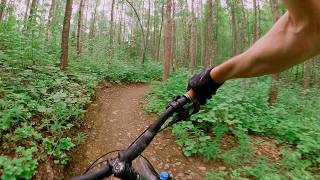
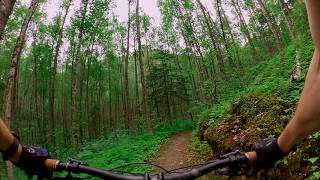
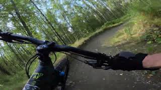
Photos of Chugiak-Eagle River Mountain Bike
Videos of Chugiak-Eagle River Mountain Bike
trail: Peters Creek Hayflats
0:17 |
30 |
Jan 7, 2023
trail: Wilson's Way (Yellow Trail)
0:47 |
126 |
May 17, 2020

trail: Wilson's Way (Yellow Trail)
0:47 |
57 |
May 17, 2020
trail: Deep Purple
3:46 |
1 |
Jun 17, 2026 , Chugiak-Eagle River
trail: Hexxus
0:22 |
0 |
Jun 16, 2026 , Chugiak-Eagle River
trail: WillPower (Light Blue)
3:49 |
3 |
Jun 15, 2026 , Chugiak-Eagle River
trail: Raven's Ridge (Blue Loop)
4:39 |
3 |
Jun 14, 2026 , Chugiak-Eagle River
trail: Lazy G
0:05 |
56 |
Sep 15, 2025 , Chugiak-Eagle River
Recent Trail Reports
Activity Feed
| username | action | type | title | date |
|---|---|---|---|---|
| stephencinti | add | video | activity #97251580 | Jun 18, 2026 @ 7:44am 2 hours |
| stephencinti | add | video | activity #97188865 | Jun 17, 2026 @ 9:15am 1 day |
| stephencinti | add | video | activity #97109291 | Jun 16, 2026 @ 7:37am 2 days |
| WillTaygan | add | route | activity #97038523 | Jun 15, 2026 @ 7:02am Jun 15, 2026 |
| stephencinti | add | video | activity #97027526 | Jun 15, 2026 @ 1:02am Jun 15, 2026 |
Recent Comments
| username | type | title | comment | date |
|---|---|---|---|---|
| trail | Awesome trail but go slow the first time you... | Aug 3, 2025 @ 4:20pm Aug 3, 2025 | ||
| trail | Good route | Dec 10, 2024 @ 10:43am Dec 10, 2024 | ||
| report | Dry and frozen surface now | Oct 19, 2024 @ 10:52am Oct 19, 2024 | ||
| report | Now dry with frozen dirt | Oct 19, 2024 @ 10:51am Oct 19, 2024 | ||
| report | Thanks!! | Nov 25, 2023 @ 4:58pm Nov 25, 2023 |
Local Badges
-

10 Blue Trails155 awarded -

Epic Ride Climb 2k20 awarded -

Climbing 10k Badge25 awarded -

Climbing 100k Badge1 awarded -

Epic Ride Descent 2k25 awarded -

Descent 10k Badge26 awarded
Bike & Skill Parks
| name | type | city | rating |
|---|---|---|---|
| Ben's Bike Playground | skill park | Chugiak-Eagle River | |
| Loretta French Skatepark | skill park | Chugiak-Eagle River |
Activity Type Stats
| activitytype | trails | distance | descent | descent distance | total vertical | rating | global rank | state rank | photos | reports | routes | ridelogs |
|---|---|---|---|---|---|---|---|---|---|---|---|---|
| Mountain Bike | 144 | 102 miles | 5,942 ft | 45 miles | 981 ft | #1,049 | #410 | 36 | 974 | 12 | 9,507 | |
| E-Bike | 40 | 46 miles | 1,581 ft | 20 miles | 571 ft | #3,043 | #1,122 | 1 | 672 | 2 | 137 | |
| Horse | 1 | 1,178 ft | 59 ft | 120 | 1 | |||||||
| Hike | 140 | 117 miles | 6,453 ft | 48 miles | 6,273 ft | #1,588 | #710 | 3 | 942 | 1 | 2,371 | |
| Trail Running | 147 | 120 miles | 6,581 ft | 49 miles | 6,273 ft | #1,212 | #437 | 942 | 1 | 522 | ||
| Snowmobile | 1 | 138 ft | 115 | 1 | ||||||||
| Snowshoe | 88 | 72 miles | 3,540 ft | 26 miles | 6,273 ft | #214 | #52 | 351 | 4 | 189 | ||
| Backcountry Ski | 6 | 7 miles | 164 ft | 2 miles | 607 ft | #531 | #151 | 114 | 4 | 694 | ||
| Nordic Ski | 67 | 45 miles | 1,939 ft | 16 miles | 978 ft | #400 | #107 | 1 | 290 | 833 |
Frequently Asked Questions About Chugiak-Eagle River
▼
What are the best places to ride in Chugiak-Eagle River?
Chugiak-Eagle River has 6 areas to explore for mountain biking. The top rated areas are:
▼
What are the highest rated mountain biking trails in Chugiak-Eagle River?
The highest rated mountain biking trails in Chugiak-Eagle River are:
- People Eater (4.2/5)
- Hot Tamale (Red Loop) (4.2/5)
- WillPower (Light Blue) (4.1/5)
- Train Ride (4.1/5)
- High Road (4.1/5)
▼
What is the best time of the year to ride in Chugiak-Eagle River?
Based on ride log data, the most popular months to ride in Chugiak-Eagle River are:
- May (84 activities)
- June (82 activities)
- December (78 activities)
▼
Where can I park to ride in Chugiak-Eagle River?
There are 14 parking locations listed in Chugiak-Eagle River. The most popular parking spots are:
- Parking
- Chugiak High School XC Ski Trail Parking
- Beach Lake Chalet Parking
- Beach Lake Chalet
- Beach Lake Lodge Parking
Activities
Trails
- Hard trails in Chugiak-Eagle River
- Easy trails in Chugiak-Eagle River
- Favorite trails in Chugiak-Eagle River
- Most ridden trails in Chugiak-Eagle River
- Singletrack in Chugiak-Eagle River
- Viewpoint trails in Chugiak-Eagle River
- Trails with technical features in Chugiak-Eagle River
- Race routes in Chugiak-Eagle River
Points of Interest
- Gus’ Drop TTF
- East Twin Peak Summit
- Mount POW/MIA Peak Summit
- Gold Star Monument Sight
- Gold Star Peak Summit
- Tucker Point Lookout Viewpoint
- Tucker Point Summit
- The Overlook Viewpoint
- Thunderbird Falls Sight
- Picnic Shelter Cabin
- Mount Gannett (9,888 ft)
- Mount Gilbert (9,498 ft)
- Bashful Peak (7,943 ft)
- By brenthillier
 NSMBA TRAILFORKS & contributors
 - Admins: CMBR, CMBR, LeeBolling, forrestt30, JDUERParks, A-Lens-for-Wanderlust
- #15293 - 6,988 views
- chugiak-eagle river activity log | embed map of Chugiak-Eagle River mountain bike trails | chugiak-eagle river mountain biking points of interest polygons
Downloading of trail gps tracks in kml & gpx formats is enabled for Chugiak-Eagle River.
You must login to download files.