close
-
Layers w
- Weather Layers
- Pro
- Pro
- Pro
- Pro
- Pro
- Pro
- More Layers
- Pro
- Pro
- Pro
- Pro
-
Upgrade to

3D
Trail Conditions
- Unknown
- Snow Groomed
- Snow Packed
- Snow Covered
- Snow Cover Partial
- Freeze/thaw Cycle
- Icy
- Prevalent Mud
- Wet
- Variable
- Ideal
- Dry
- Very Dry
Trail Flow (Ridden Direction)
Trailforks scans users ridelogs to determine the most popular direction each trail is ridden. A good flowing trail network will have most trails flowing in a single direction according to their intension.
The colour categories are based on what percentage of riders are riding a trail in its intended direction.
The colour categories are based on what percentage of riders are riding a trail in its intended direction.
- > 96%
- > 90%
- > 80%
- > 70%
- > 50%
- < 50%
- bi-directional trail
- no data
Trail Last Ridden
Trailforks scans ridelogs to determine the last time a trail was ridden.
- < 2 days
- < 1 week
- < 2 weeks
- < 1 month
- < 6 months
- > 6 months
Trail Ridden Direction
The intended direction a trail should be ridden.
- Downhill Only
- Downhill Primary
- Both Directions
- Uphill Primary
- Uphill Only
- One Direction
Contribute Details
Colors indicate trail is missing specified detail.
- Description
- Photos
- Description & Photos
- Videos
Trail Popularity ?
Trailforks scans ridelogs to determine which trails are ridden the most in the last 9 months.
Trails are compared with nearby trails in the same city region with a possible 25 colour shades.
Think of this as a heatmap, more rides = more kinetic energy = warmer colors.
- most popular
- popular
- less popular
- not popular
ATV/ORV/OHV Filter
Max Vehicle Width
inches
US Cell Coverage
Legend

Radar Time
Activity Recordings
Trailforks uses anonymized public activity data.
?
Activity Recordings
Trailforks uses anonymized public activity data.
?
Personal Heatmap
▶
Activity Types
all
/
none
▶
Options
2
Date range
month
–
Winter Trails
Warning
A routing network for winter maps does not exist. Selecting trails using the winter trails layer has been disabled.
Missing Trails
Most Popular
Least Popular
Trails are colored based on popularity. The more popular a trail is, the more red. Less popular trails trend towards green.
Jump Magnitude Heatmap
Heatmap of where riders jump on trails. Zoom in to see individual jumps, click circles to view jump details.
BC Backroad Status
![map legend]()
Service Road Atlas is a free to use, community-driven service for viewing and creating reports on the numerous back-country service roads around B.C. and Alberta.

Slope Aspect
Direction the slope faces
Trails Deemphasized
Trails are shown in grey.
Only show trails with no bike usage.
Suggested Layers
Based on selected activity type
Save the current map location and zoom level as your default home location whenever this page is loaded.
Save
No description for Clarksville has been added yet!
Login or register to submit one.
Activities Click to view
- Mountain Bike
6 trails
- E-Bike
6 trails
- Adaptive Bike
- Hike
2 trails
- Trail Running
2 trails
Region Details
- 2
- 3
- 1
Region Status
Caution as of Oct 15, 2025Stats
- Avg Trail Rating
- Trails (view details)
- 6
- Trails Mountain Bike
- 6
- Trails E-Bike
- 6
- Trails Hike
- 2
- Trails Trail Running
- 2
- Total Distance
- 8 miles
- Total Descent Distance
- 4 miles
- Total Descent
- 1,084 ft
- Total Vertical
- 419 ft
- Highest Trailhead
- 762 ft
- Reports
- 66
- Photos
- 20
- Ridden Counter
- 717
Sub Regions
-
Red Lick Trails
- 1
- 3
- 1
Popular Clarksville Mountain Biking Trails
• 95 ★ 4.8 • 1,785 ft • 0 ft • 100 •
If you only have one word to describe this trail, it's FAST. Huge berms and wide smooth tread keep you confident as you make your way down the mountain. We recommend a lap down for riders of all skill levels, but keep your speed in check!
• 75 ★ 5.0 • 1,617 ft • 2 ft • 91 •
If you're comfortable on and want to progress your skills on fast downhill trails, this is the one for you.
• 85 ★ 5.0 • 6 miles • 417 ft • 90 •
Classic blue singletrack. This is a two-way multi-use trail that is open to mountain bikers, trail runners, hikers, and birdwatchers. It rides well both directions, but the descent from the top when riding counter-clockwise is hard to...
• 60 ★ 5.0 • 1,493 ft • 3 ft • 73 •
This one is for the advanced riders seeking rugged rock slabs, drops, and gravity cavities. Impressive wood work compliments the natural rocky terrain to create a mountain side roller coaster.
• 70 ★ 5.0 • 1,709 ft • 0 ft • 69 •
This is the more raw and technical of the two blue DH trails. With a mixture of flow and techy rock, this trail is sure to push you to the edge.
• 5 ★ 0.0 • 3,839 ft • 10 ft • 4 •
Less popular green difficulty family friendly singletrack. This mountain bike primary trail can be used both directions. It features skinny and teeter totter. On average it takes 8 minutes to complete this trail.
Photos of Clarksville Mountain Bike
Videos of Clarksville Mountain Bike
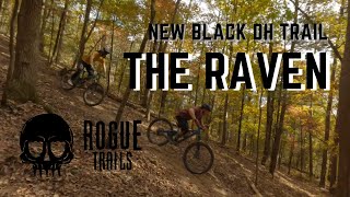
trail: Raven
0:03 |
404 |
Apr 14, 2023 , Clarksville
Recent Trail Reports
| status | trail | date | condition | info | user |
|---|---|---|---|---|---|
| John Jolly | Oct 15, 2025 @ 1:16pm (America/Chicago) Oct 15, 2025 | Ideal | Atomic2002 | ||
| Redlick Hub | Jul 8, 2025 @ 7:03pm Jul 8, 2025 | Ideal | Atomic2002 | ||
| Broken Sword | Mar 31, 2025 @ 3:51pm Mar 31, 2025 | Unknown | joescott23 | ||
| Osage Escapade | Nov 20, 2024 @ 3:15pm Nov 20, 2024 | Wet | Atomic2002 | ||
| Covee's Cadence | Sep 14, 2024 @ 9:24am Sep 14, 2024 | Ideal | BarryxXsmvV | ||
| Spadra Creek Single Track 2 | Jan 1, 2024 @ 4:52am Jan 1, 2024 | Ideal | Atomic2002 | ||
| Talihina Tour | Dec 16, 2023 @ 5:00am Dec 16, 2023 | Variable | Atomic2002 | ||
| Redlick Hub Parking Access | Jul 24, 2023 @ 11:25am Jul 24, 2023 | Variable | Atomic2002 | ||
| Raven | May 20, 2023 @ 3:31pm May 20, 2023 | Ideal | NABO10 |
Activity Feed
| username | action | type | title | date |
|---|---|---|---|---|
| fifty50master | ridden | trail | activity #95000735 | May 18, 2026 @ 2:32pm May 18, 2026 |
| CorbinDqDjsZ | wishlist | trail | activity #94275019 | May 8, 2026 @ 2:12pm May 8, 2026 |
| chrislamb27 | wishlist | region | activity #94179946 | May 6, 2026 @ 3:13pm May 6, 2026 |
| Green4061 | wishlist | trail | activity #90907024 | Mar 20, 2026 @ 3:06am Mar 20, 2026 |
| snealthy | ridden | trail | activity #86610909 | Jan 3, 2026 @ 8:43pm Jan 3, 2026 |
Recent Comments
| username | type | title | comment | date |
|---|---|---|---|---|
| trail | There’s a HUGE tree down going into the... | Jun 2, 2025 @ 1:18pm Jun 2, 2025 | ||
| trail | Fast trail with nice berms | Sep 14, 2024 @ 1:10pm Sep 14, 2024 | ||
| trail | Super fun flow trail. Nice jumps and berms.... | Sep 14, 2024 @ 1:09pm Sep 14, 2024 | ||
| trail | Fun trail with some good flow and some chunky... | Sep 14, 2024 @ 1:09pm Sep 14, 2024 | ||
| trail | Lots of steep tech features and drops. | Sep 14, 2024 @ 8:14am Sep 14, 2024 |
Activity Type Stats
| activitytype | trails | distance | descent | descent distance | total vertical | rating | global rank | state rank | photos | reports | routes | ridelogs |
|---|---|---|---|---|---|---|---|---|---|---|---|---|
| Mountain Bike | 6 | 8 miles | 1,083 ft | 4 miles | 420 ft | #4,850 | #1,632 | 20 | 66 | 606 | ||
| E-Bike | 6 | 8 miles | 1,083 ft | 4 miles | 420 ft | #7,993 | #2,421 | 66 | 43 | |||
| Hike | 2 | 7 miles | 423 ft | 2 miles | 420 ft | #13,253 | #4,800 | 62 | 32 | |||
| Trail Running | 2 | 7 miles | 423 ft | 2 miles | 420 ft | #12,826 | #4,521 | 62 | 1 |
Frequently Asked Questions About Clarksville
▼
What are the best places to ride in Clarksville?
Clarksville has 1 areas to explore for mountain biking. The top rated areas are:
▼
What are the highest rated mountain biking trails in Clarksville?
The highest rated mountain biking trails in Clarksville are:
- Osage Escapade (4.3/5)
- Raven (4.2/5)
- Talihina Tour (4.1/5)
- Broken Sword (4.1/5)
- Covee's Cadence (4.1/5)
▼
What is the best time of the year to ride in Clarksville?
Based on ride log data, the most popular months to ride in Clarksville are:
- August (1 activities)
- December (1 activities)
▼
Where can I park to ride in Clarksville?
There are 2 parking locations listed in Clarksville. The most popular parking spots are:
- By Atomic2002 & contributors
- Admins: OZ TRAILS, thomcerny
- #48731 - 2,501 views
- clarksville activity log | embed map of Clarksville mountain bike trails | clarksville mountain biking points of interest
Downloading of trail gps tracks in kml & gpx formats is enabled for Clarksville.
You must login to download files.