close
-
Layers w
- Weather Layers
- Pro
- Pro
- Pro
- Pro
- Pro
- Pro
- More Layers
- Pro
- Pro
- Pro
- Pro
-
Upgrade to

3D
Trail Conditions
- Unknown
- Snow Groomed
- Snow Packed
- Snow Covered
- Snow Cover Partial
- Freeze/thaw Cycle
- Icy
- Prevalent Mud
- Wet
- Variable
- Ideal
- Dry
- Very Dry
Trail Flow (Ridden Direction)
Trailforks scans users ridelogs to determine the most popular direction each trail is ridden. A good flowing trail network will have most trails flowing in a single direction according to their intension.
The colour categories are based on what percentage of riders are riding a trail in its intended direction.
The colour categories are based on what percentage of riders are riding a trail in its intended direction.
- > 96%
- > 90%
- > 80%
- > 70%
- > 50%
- < 50%
- bi-directional trail
- no data
Trail Last Ridden
Trailforks scans ridelogs to determine the last time a trail was ridden.
- < 2 days
- < 1 week
- < 2 weeks
- < 1 month
- < 6 months
- > 6 months
Trail Ridden Direction
The intended direction a trail should be ridden.
- Downhill Only
- Downhill Primary
- Both Directions
- Uphill Primary
- Uphill Only
- One Direction
Contribute Details
Colors indicate trail is missing specified detail.
- Description
- Photos
- Description & Photos
- Videos
Trail Popularity ?
Trailforks scans ridelogs to determine which trails are ridden the most in the last 9 months.
Trails are compared with nearby trails in the same city region with a possible 25 colour shades.
Think of this as a heatmap, more rides = more kinetic energy = warmer colors.
- most popular
- popular
- less popular
- not popular
ATV/ORV/OHV Filter
Max Vehicle Width
inches
US Cell Coverage
Legend

Radar Time
Activity Recordings
Trailforks uses anonymized public activity data.
?
Activity Recordings
Trailforks uses anonymized public activity data.
?
Personal Heatmap
▶
Activity Types
all
/
none
▶
Options
2
Date range
month
–
Winter Trails
Warning
A routing network for winter maps does not exist. Selecting trails using the winter trails layer has been disabled.
Missing Trails
Most Popular
Least Popular
Trails are colored based on popularity. The more popular a trail is, the more red. Less popular trails trend towards green.
Jump Magnitude Heatmap
Heatmap of where riders jump on trails. Zoom in to see individual jumps, click circles to view jump details.
BC Backroad Status
![map legend]()
Service Road Atlas is a free to use, community-driven service for viewing and creating reports on the numerous back-country service roads around B.C. and Alberta.

Slope Aspect
Direction the slope faces
Trails Deemphasized
Trails are shown in grey.
Only show trails with no bike usage.
Suggested Layers
Based on selected activity type
Save the current map location and zoom level as your default home location whenever this page is loaded.
SaveClearwater has been developing mountain bike trails since 2015.
The network is being developed at the Candle Creek cross country ski area managed by the Wells Gray Outdoors Club.
From Clearwater travel north (follow the blue MTB trail signs from the highway), take a left on Candle Creek Rd, a right on Barber Rd - trails are signed at the end of the road. There is a second parking area at the bottom of the network - at the Raft canyon viewpoint 2 km on Road 9 forest service road, 4 km north of Clearwater (turn at Wadleggers mill).
The network is very accessible to families - with a variety of two way green trails close to the Candle Creek parking lot, and Sweet Jane is a very easy blue - which can be shuttled from Road 9. If you are looking for a long descent, link Brain Shake to Greasy Jungle, to Sweet Jane or Raft Rim.
There is also riding on some park trails (see North Thompson and Wells Gray Park).
source: Wells Gray Outdoor Club
Files
Activities Click to view
- Mountain Bike
32 trails
- E-Bike
9 trails
- Adaptive Bike
0 trails
- Winter Fat Bike
0 trails
- Hike
66 trails
- Trail Running
66 trails
- Snowshoe
48 trails
- Downhill Ski
8 trails
- Backcountry Ski
32 trails
- Nordic Ski
33 trails
Region Details
- 3
- 1
- 11
- 9
- 8
Region Status
Caution as of Jun 20, 2026Stats
- Avg Trail Rating
- Trails (view details)
- 76
- Trails Mountain Bike
- 32
- Trails E-Bike
- 9
- Trails Horse
- 1
- Trails Hike
- 66
- Trails Trail Running
- 66
- Trails Snowshoe
- 48
- Trails Downhill Ski
- 8
- Trails Backcountry Ski
- 32
- Trails Nordic Ski
- 33
- Total Distance
- 117 miles
- Total Descent
- 14,027 ft
- Total Vertical
- 6,420 ft
- Highest Trailhead
- 7,736 ft
- Reports
- 1,841
- Photos
- 188
- Ridden Counter
- 6,617
Sub Regions
-
Candle Creek
- 1
- 8
- 5
- 8
-
Wells Gray Provincial Park
- 2
- 2
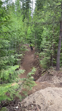
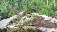
Popular Clearwater Mountain Biking Trails
• 100 ★ 4.2 • 2,375 ft • 140 ft • 468 •
Built in 2017. This two way single track pumps and rolls through mature Fir and Cedar Forest, some big old Fir trees along the trail. As green as it gets ! This trail is a network favourite, great for bikers and hikers - 'where the...
• 5 ★ 4.6 • 2,385 ft • 8 ft • 442 •
Our little piece of bike park - if you like to hit jumps it's a great place to session. About 20 features - all are rollable. Lower half is really a blue with lots of small beginner type jumps. Just pedal up the road from top of - easy...
• 5 ★ 4.6 • 2 miles • 548 ft • 386 •
completed in 2017 - 3.8 km (GPS track shortens actual slope distance). This two way featured single track climbs above through Fir forests and open cut blocks. Big views of the valley and rivers - great at sunset. Lots of exposed rock...
• 5 ★ 4.8 • 5,253 ft • 10 ft • 383 •
Provides a loop option for climbing up or - or shuttle accessible. Designed to have an 'old school' feel - loamy bits, rooty bits, some drops, some tech, some 'janky' corners and some adventure options. May take a few runs to get the...
• 5 ★ 3.5 • 1,913 ft • 78 ft • 315 •
XC ski trail that connects to Candle Creek trailhead
• 5 ★ 3.2 • 1 mile • 433 ft • 298 •
built in 2016 with pumps and rollers, a fun step down / step up through a gully. Descends through open Fir forests and brushy cutblocks. Nice finish with open swoopy turns in mature forest. Great climbing trail as well - loop with descent.
• 5 ★ 3.4 • 2 miles • 512 ft • 293 •
- built the summer of 2020 by Traub Contracting. As green as it gets. This trail provides a very easy green climb from the bottom of the network to Candle Creek Parking lot and Ridge zone. The climb takes you through a mix of...
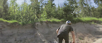
Photos of Clearwater Mountain Bike
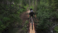
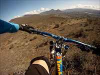
Videos of Clearwater Mountain Bike
trail: Pub Feed
0:08 |
1 |
Jun 8, 2025
trail: Pub Feed
0:06 |
491 |
Sep 16, 2020

trail: Raft Rim
0:08 |
361 |
Jul 19, 2019
trail: Rock Lobster
3:01 |
314 |
Jun 23, 2016

trail: Sweet Jane
4:59 |
1788 |
Jul 22, 2015
trail: Sweet Jane
4:59 |
9079 |
Jul 20, 2015
trail: Fat Lip
3:16 |
5814 |
Jul 28, 2013
trail: Fat Lip
2:12 |
717 |
Mar 24, 2013
Recent Trail Reports
| status | trail | date | condition | info | user |
|---|---|---|---|---|---|
| Bailey's Chute Trail | May 18, 2026 @ 11:35am (America/Vancouver) May 18, 2026 | Ideal | antonio7650 | ||
| Convoy | May 10, 2026 @ 3:49pm (America/Vancouver) May 10, 2026 | Ideal | Shafto | ||
| Pub Feed | May 10, 2026 @ 3:49pm (America/Vancouver) May 10, 2026 | Dry | Shafto | ||
| Pub Feed | May 10, 2026 @ 3:49pm (America/Vancouver) May 10, 2026 | Dry | Shafto | ||
| Higher Ground | May 10, 2026 @ 3:49pm (America/Vancouver) May 10, 2026 | Ideal | Shafto | ||
| Fiddlers Green | May 10, 2026 @ 3:49pm (America/Vancouver) May 10, 2026 | Ideal | Shafto | ||
| Higher Ground | May 3, 2026 @ 3:50pm (America/Vancouver) May 3, 2026 | Dry | ethanm | ||
| Pub Feed | May 3, 2026 @ 3:50pm (America/Vancouver) May 3, 2026 | Dry | ethanm | ||
| Swamp Loop | Apr 26, 2026 @ 8:25am (America/Vancouver) Apr 26, 2026 | Unknown | solmountain WGOC | ||
| Swamp Connector | Apr 26, 2026 @ 8:25am (America/Vancouver) Apr 26, 2026 | Unknown | solmountain WGOC |
Activity Feed
| username | action | type | title | date |
|---|---|---|---|---|
| PascaldMtTBI | ridden | trail | activity #97875370 | Jun 26, 2026 @ 9:09pm 3 days |
| Paulb9pAfB | wishlist | trail | activity #97577272 and 2 more | Jun 22, 2026 @ 12:04pm Jun 22, 2026 |
| brendahoule | wishlist | region | activity #97432686 | Jun 20, 2026 @ 2:18pm Jun 20, 2026 |
| Archbagger | ridden | trail | activity #96848016 | Jun 12, 2026 @ 9:35pm Jun 12, 2026 |
| chlorbdx | wishlist | region | activity #96712010 | Jun 10, 2026 @ 7:03pm Jun 10, 2026 |
Recent Comments
| username | type | title | comment | date |
|---|---|---|---|---|
| report | Open Apr 4 | Apr 4, 2026 @ 7:04am Apr 4, 2026 | ||
| report | Open Apr 4 | Apr 4, 2026 @ 7:03am Apr 4, 2026 | ||
| report | Open Apr 4 | Apr 4, 2026 @ 7:03am Apr 4, 2026 | ||
| report | Open Apr 4 | Apr 4, 2026 @ 7:02am Apr 4, 2026 | ||
| report | Open Apr 4 | Apr 4, 2026 @ 7:02am Apr 4, 2026 |
Local Badges
-

Epic Ride Climb 2k31 awarded -

Climbing 10k Badge15 awarded -

Climbing 100k Badge2 awarded -

Epic Ride Descent 2k31 awarded -

Descent 10k Badge18 awarded -

Descent 100k Badge2 awarded
Activity Type Stats
| activitytype | trails | distance | descent | descent distance | total vertical | rating | global rank | state rank | photos | reports | routes | ridelogs |
|---|---|---|---|---|---|---|---|---|---|---|---|---|
| Mountain Bike | 32 | 33 miles | 4,514 ft | 11 miles | 2,224 ft | #3,106 | #84 | 188 | 1,841 | 4,225 | ||
| E-Bike | 9 | 8 miles | 551 ft | 1 mile | 1,325 ft | #5,878 | #109 | 1,700 | 97 | |||
| Horse | 1 | 1,913 ft | 36 ft | 919 ft | 79 ft | 195 | 19 | |||||
| Hike | 66 | 111 miles | 9,760 ft | 34 miles | 6,421 ft | #1,781 | #73 | 1,808 | 1 | 1,308 | ||
| Trail Running | 66 | 111 miles | 9,760 ft | 34 miles | 6,421 ft | #1,717 | #59 | 1,808 | 159 | |||
| Snowshoe | 48 | 91 miles | 7,231 ft | 28 miles | 6,375 ft | #202 | #21 | 385 | 83 | |||
| Downhill Ski | 8 | 4 miles | 3,337 ft | 4 miles | 817 ft | #620 | #25 | 3 | ||||
| Backcountry Ski | 32 | 77 miles | 5,640 ft | 23 miles | 5,784 ft | #255 | #17 | 337 | ||||
| Nordic Ski | 33 | 78 miles | 6,083 ft | 24 miles | 5,814 ft | #312 | #22 | 1 | 185 |
Frequently Asked Questions About Clearwater
▼
What are the best places to ride in Clearwater?
Clearwater has 4 areas to explore for mountain biking. The top rated areas are:
▼
What are the highest rated mountain biking trails in Clearwater?
The highest rated mountain biking trails in Clearwater are:
- Raft Rim (4.5/5)
- Brain Shake (4.5/5)
- Rock Lobster (4.4/5)
- Higher Ground (4.4/5)
- Fat Lip (4.3/5)
▼
What is the best time of the year to ride in Clearwater?
Based on ride log data, the most popular months to ride in Clearwater are:
- August (115 activities)
- July (84 activities)
- June (63 activities)
▼
Where can I park to ride in Clearwater?
There are 22 parking locations listed in Clearwater. The most popular parking spots are: View all parking and trailhead locations on the map to plan your visit.
Activities
Trails
Points of Interest
- Marcus Falls Viewpoint
- Myanth Falls Sight
- Myanth Falls Viewpoint
- Sticta Falls Viewpoint
- Spahats Falls Sight
- Spahats Falls Viewpoint
- Spahats Falls Viewing Platform Viewpoint
- Spahats Falls Viewpoint
- Bailey's Chute Sight
- Marcus Falls Sight
- Harp Mountain (7,470 ft)
- Granite Mountain (7,365 ft)
- Mount Bob Mitchell (7,054 ft)
- By solmountain
 WGOC & contributors
 - Admins: BCBR, TrailsBC, BCORMA, DSBC, wheelmaniac3, bcpunk, canadianenduro, WGOC
- #8620 - 18,341 views
- clearwater activity log | embed map of Clearwater mountain bike trails | clearwater mountain biking points of interest
Downloading of trail gps tracks in kml & gpx formats is enabled for Clearwater.
You must login to download files.