close
-
Layers w
- Weather Layers
- Pro
- Pro
- Pro
- Pro
- Pro
- Pro
- More Layers
- Pro
- Pro
- Pro
- Pro
-
Upgrade to

3D
Trail Conditions
- Unknown
- Snow Groomed
- Snow Packed
- Snow Covered
- Snow Cover Partial
- Freeze/thaw Cycle
- Icy
- Prevalent Mud
- Wet
- Variable
- Ideal
- Dry
- Very Dry
Trail Flow (Ridden Direction)
Trailforks scans users ridelogs to determine the most popular direction each trail is ridden. A good flowing trail network will have most trails flowing in a single direction according to their intension.
The colour categories are based on what percentage of riders are riding a trail in its intended direction.
The colour categories are based on what percentage of riders are riding a trail in its intended direction.
- > 96%
- > 90%
- > 80%
- > 70%
- > 50%
- < 50%
- bi-directional trail
- no data
Trail Last Ridden
Trailforks scans ridelogs to determine the last time a trail was ridden.
- < 2 days
- < 1 week
- < 2 weeks
- < 1 month
- < 6 months
- > 6 months
Trail Ridden Direction
The intended direction a trail should be ridden.
- Downhill Only
- Downhill Primary
- Both Directions
- Uphill Primary
- Uphill Only
- One Direction
Contribute Details
Colors indicate trail is missing specified detail.
- Description
- Photos
- Description & Photos
- Videos
Trail Popularity ?
Trailforks scans ridelogs to determine which trails are ridden the most in the last 9 months.
Trails are compared with nearby trails in the same city region with a possible 25 colour shades.
Think of this as a heatmap, more rides = more kinetic energy = warmer colors.
- most popular
- popular
- less popular
- not popular
ATV/ORV/OHV Filter
Max Vehicle Width
inches
US Cell Coverage
Legend

Radar Time
Activity Recordings
Trailforks uses anonymized public activity data.
?
Activity Recordings
Trailforks uses anonymized public activity data.
?
Personal Heatmap
▶
Activity Types
all
/
none
▶
Options
2
Date range
month
–
Winter Trails
Warning
A routing network for winter maps does not exist. Selecting trails using the winter trails layer has been disabled.
Missing Trails
Most Popular
Least Popular
Trails are colored based on popularity. The more popular a trail is, the more red. Less popular trails trend towards green.
Jump Magnitude Heatmap
Heatmap of where riders jump on trails. Zoom in to see individual jumps, click circles to view jump details.
BC Backroad Status
![map legend]()
Service Road Atlas is a free to use, community-driven service for viewing and creating reports on the numerous back-country service roads around B.C. and Alberta.

Slope Aspect
Direction the slope faces
Trails Deemphasized
Trails are shown in grey.
Only show trails with no bike usage.
Suggested Layers
Based on selected activity type
Save the current map location and zoom level as your default home location whenever this page is loaded.
Save
No description for Cody has been added yet!
Login or register to submit one.
Activities Click to view
- Mountain Bike
108 trails
- E-Bike
31 trails
- Gravel Bike
2 trails
- Adaptive Bike
3 trails
- Winter Fat Bike
4 trails
- Horse
122 trails
- Hike
185 trails
- Trail Running
185 trails
- ATV/ORV/OHV
13 trails
- Downhill Ski
31 trails
- Nordic Ski
17 trails
Region Details
- 14
- 8
- 66
- 20
Region Status
Open as of 3 daysStats
- Avg Trail Rating
- Trails (view details)
- 235
- Trails Mountain Bike
- 108
- Trails E-Bike
- 31
- Trails Gravel Bike
- 2
- Trails Adaptive Bike
- 3
- Trails Winter Fat Bike
- 4
- Trails Horse
- 122
- Trails Hike
- 185
- Trails Trail Running
- 185
- Trails Dirtbike/Moto
- 1
- Trails ATV/ORV/OHV
- 13
- Trails Downhill Ski
- 31
- Trails Nordic Ski
- 17
- Total Distance
- 676 miles
- Total Descent
- 75,572 ft
- Total Vertical
- 7,265 ft
- Highest Trailhead
- 11,744 ft
- Reports
- 1,513
- Photos
- 302
- Ridden Counter
- 3,321
Sub Regions
-
Beck Lake
- 5
- 12
- 4
-
Oregon Basin
- 1
-
Outlaw Trails
- 3
- 14
- 9
-
Shoshone National Forest
- 37
- 2
Popular Cody Mountain Biking Trails
• 100 ★ 4.5 • 2 miles • 346 ft • 190 •
Popular green difficulty singletrack. This mountain bike primary trail. On average it takes 15 minutes to complete this trail.
• 90 ★ 5.0 • 1 mile • 5 ft • 140 •
A great beginner with some big berms and lots of small jumps table top jumps. It is all at a nice relaxed angle. A really good place to start to learn to jump or pedal hard push your limits. Either way it is loads of fun.
• 100 ★ 5.0 • 1,424 ft • 2 ft • 130 •
Popular blue difficulty singletrack. This mountain bike primary trail can be used both directions. On average it takes 17 minutes to complete this trail.
• 95 ★ 5.0 • 1 mile • 54 ft • 124 •
The sits within the perimeter defined by this trail. There is a pump track, drop zone with HUGE berms, a skills area with a lot of natural rock features and three jump lines. The jump lines range from beginner small table tops. The...
• 85 ★ 5.0 • 4,636 ft • 52 ft • 111 •
This is a machine built with significant berms and table-top jumps.
• 95 ★ 4.0 • 2,877 ft • 119 ft • 107 •
Popular blue difficulty singletrack. This mountain bike primary trail. On average it takes 7 minutes to complete this trail.
• 85 ★ 4.0 • 1 mile • 290 ft • 100 •
This is the main trail that gets you into the network. In other words, there is really no avoiding it. The beginning (southern end) of this trail starts with a difficult climb, both aerobically and with some moderately technical...
• 90 ★ 5.0 • 3 miles • 645 ft • 100 •
This is a good trail for the climb to the top. Ends at a fence covered in bones. Large sections of the trail were rebuilt in November 2025
Cody Mountain Bike Routes
★ 5.0 • 4 miles • 627 ft • 6 • Loop •
The easiest short loop from the trailhead, but still not easy. The trails are all peppered with...
20 miles • 2,733 ft • 13 • Out & Back •
This route encompasses every significant trail in the area in the most efficient rideable way possible....
★ 2.0 • 5 miles • 684 ft • 3 •
Best taste of Outlaw: all the funs, all the memories, low commitment.
• 4 miles • 328 ft • 3 •
• 3 miles • 141 ft • 4 •
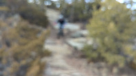
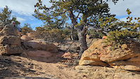
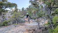
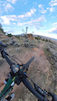
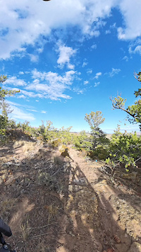
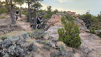
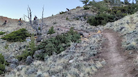
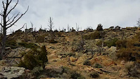
Photos of Cody Mountain Bike
Videos of Cody Mountain Bike
trail: Banger
0:05 |
9 |
Apr 8, 2026
trail: The Shiv
0:06 |
23 |
Feb 7, 2026
trail: Above the Law
0:20 |
9 |
Feb 2, 2026
trail: The Shiv
0:26 |
20 |
Nov 17, 2025
trail: The Shank
0:14 |
18 |
Nov 17, 2025
trail: The Shiv
0:09 |
21 |
Oct 13, 2025
trail: The Shiv
0:16 |
15 |
Oct 13, 2025
trail: Anarchy
0:16 |
16 |
Oct 13, 2024
Recent Trail Reports
| status | trail | date | condition | info | user |
|---|---|---|---|---|---|
| Final Approach | Jun 22, 2026 @ 5:45pm (America/Boise) 3 days | Dry | EricGBTlbr | ||
| Daily Grind | Jun 22, 2026 @ 5:45pm (America/Boise) 3 days | Dry | EricGBTlbr | ||
| Prickly Pear | Jun 14, 2026 @ 2:37pm (America/Boise) Jun 14, 2026 | Dry | EricGBTlbr | ||
| Accomplice - Upper | Jun 11, 2026 @ 5:49pm (America/Boise) Jun 11, 2026 | Dry | EricGBTlbr | ||
| Outlaw | Jun 11, 2026 @ 5:49pm (America/Boise) Jun 11, 2026 | Dry | EricGBTlbr | ||
| The Accomplice - Lower | Jun 11, 2026 @ 5:49pm (America/Boise) Jun 11, 2026 | Dry | EricGBTlbr | ||
| Outlaw alt lines easier | Jun 11, 2026 @ 5:49pm (America/Boise) Jun 11, 2026 | Dry | EricGBTlbr | ||
| Outlaw Start alt line | Jun 11, 2026 @ 5:49pm (America/Boise) Jun 11, 2026 | Dry | EricGBTlbr | ||
| Outlaw Access | Jun 11, 2026 @ 5:49pm (America/Boise) Jun 11, 2026 | Dry | EricGBTlbr | ||
| Upslope | May 27, 2026 @ 10:10am (America/Denver) May 27, 2026 | Dry | JohninCody PCP |
Activity Feed
| username | action | type | title | date |
|---|---|---|---|---|
| EricGBTlbr | add | report | activity #97596568 and 1 more | Jun 22, 2026 @ 6:12pm 3 days |
| davidheninger | comment | trail | activity #97569550 | Jun 22, 2026 @ 10:06am Jun 22, 2026 |
| EricGBTlbr | add | report | activity #97016900 | Jun 14, 2026 @ 6:12pm Jun 14, 2026 |
| JohninCody | add | photo | activity #96814247 and 4 more | Jun 12, 2026 @ 10:40am Jun 12, 2026 |
| EricGBTlbr | add | report | activity #96796190 and 5 more | Jun 12, 2026 @ 5:20am Jun 12, 2026 |
Recent Comments
| username | type | title | comment | date |
|---|---|---|---|---|
| trail | This was a fun ride in the middle of June. ... | Jun 22, 2026 @ 10:06am Jun 22, 2026 | ||
| trail | A fair bit of double track, be nice to have... | Aug 18, 2025 @ 10:47am Aug 18, 2025 | ||
| trail | I really enjoyed climbing this to connect to... | Aug 18, 2025 @ 9:25am Aug 18, 2025 | ||
| trail | Super fun blue flow-tech trail | Aug 18, 2025 @ 9:24am Aug 18, 2025 | ||
| trail | As awesome as a black tech trail gets!!!!!... | Aug 18, 2025 @ 9:22am Aug 18, 2025 |
Local Badges
-

10 Blue Trails31 awarded -

Epic Ride 50k126 awarded -

Top 10 Trails3 awarded -

Completionist0 awarded -

Big Ride 30k274 awarded -
Completionist0 awarded
Bike & Skill Parks
| name | type | city | rating |
|---|---|---|---|
| Beck Lake Bike Park | skill park | Cody |
Activity Type Stats
| activitytype | trails | distance | descent | descent distance | total vertical | rating | global rank | state rank | photos | reports | routes | ridelogs |
|---|---|---|---|---|---|---|---|---|---|---|---|---|
| Mountain Bike | 108 | 289 miles | 34,557 ft | 82 miles | 7,264 ft | #789 | #307 | 296 | 1,513 | 4 | 3,968 | |
| E-Bike | 31 | 21 miles | 2,605 ft | 6 miles | 968 ft | #4,103 | #1,361 | 860 | 1 | 269 | ||
| Gravel Bike | 2 | 2 miles | 164 ft | 3,615 ft | 292 ft | #527 | #1,063 | 101 | 60 | |||
| Adaptive Bike | 3 | 4 miles | 164 ft | 4,324 ft | 331 ft | #485 | #1,782 | 113 | 1 | |||
| Winter Fat Bike | 4 | 10 miles | 738 ft | 2 miles | 991 ft | #290 | #1,053 | 116 | ||||
| Horse | 122 | 561 miles | 55,299 ft | 130 miles | 7,241 ft | #19 | #313 | 172 | 1 | |||
| Hike | 185 | 661 miles | 69,806 ft | 161 miles | 7,264 ft | #135 | #76 | 5 | 1,509 | 943 | ||
| Trail Running | 185 | 661 miles | 69,806 ft | 161 miles | 7,264 ft | #115 | #55 | 1,509 | 172 | |||
| Dirtbike/Moto | 1 | 1,398 ft | 3 ft | 75 ft | 157 ft | 170 | 2 | |||||
| ATV/ORV/OHV | 13 | 62 miles | 2,717 ft | 11 miles | 6,093 ft | #418 | #130 | 170 | ||||
| Downhill Ski | 31 | 5 miles | 4,915 ft | 4 miles | 4,262 ft | #457 | #180 | 47 | ||||
| Nordic Ski | 17 | 9 miles | 764 ft | 4 miles | 236 ft | #817 | #321 | 28 |
Frequently Asked Questions About Cody
▼
What are the best places to ride in Cody?
Cody has 8 areas to explore for mountain biking. The top rated areas are:
▼
What are the highest rated mountain biking trails in Cody?
The highest rated mountain biking trails in Cody are:
- Final Approach (4.3/5)
- Twisted Sister (4.2/5)
- Jail Break (4.2/5)
- Above the Law (4.2/5)
- Scorpion (4.1/5)
▼
What is the best time of the year to ride in Cody?
Based on ride log data, the most popular months to ride in Cody are:
- July (123 activities)
- August (90 activities)
- June (70 activities)
▼
Where can I park to ride in Cody?
There are 41 parking locations listed in Cody. The most popular parking spots are:
- Outlaw Trailhead
- Upper Parking
- Cattle Guard - Park Here
- Dead Indian Creek Trailhead Parking
- Cabin Creek/South Fork Cut Access Trailhead Parkng
Activities
Trails
Points of Interest
- Little Sunlight Camping Area
- Private Property Boundary [Private Property Boundary] Other
- Pahaska Tepee Lodge
- Sleeping Gaint Lodge
- Post Point Summit
- Bridge over canal
- Foot Bridge
- Camp Buffalo Bill Camping
- Bridle Veil Falls Sight
- Dead Indian Campground Camping
- Jojo Mountain (12,552 ft)
- Francs Peak (12,470 ft)
- Mount Crosby (12,438 ft)
- By brenthillier
 NSMBA TRAILFORKS & contributors
 - Admins: PCP
- #3480 - 17,186 views
- cody activity log | embed map of Cody mountain bike trails | cody mountain biking points of interest
Downloading of trail gps tracks in kml & gpx formats is enabled for Cody.
You must login to download files.