close
-
Layers w
- Weather Layers
- Pro
- Pro
- Pro
- Pro
- Pro
- Pro
- More Layers
- Pro
- Pro
- Pro
- Pro
-
Upgrade to

3D
Trail Conditions
- Unknown
- Snow Groomed
- Snow Packed
- Snow Covered
- Snow Cover Partial
- Freeze/thaw Cycle
- Icy
- Prevalent Mud
- Wet
- Variable
- Ideal
- Dry
- Very Dry
Trail Flow (Ridden Direction)
Trailforks scans users ridelogs to determine the most popular direction each trail is ridden. A good flowing trail network will have most trails flowing in a single direction according to their intension.
The colour categories are based on what percentage of riders are riding a trail in its intended direction.
The colour categories are based on what percentage of riders are riding a trail in its intended direction.
- > 96%
- > 90%
- > 80%
- > 70%
- > 50%
- < 50%
- bi-directional trail
- no data
Trail Last Ridden
Trailforks scans ridelogs to determine the last time a trail was ridden.
- < 2 days
- < 1 week
- < 2 weeks
- < 1 month
- < 6 months
- > 6 months
Trail Ridden Direction
The intended direction a trail should be ridden.
- Downhill Only
- Downhill Primary
- Both Directions
- Uphill Primary
- Uphill Only
- One Direction
Contribute Details
Colors indicate trail is missing specified detail.
- Description
- Photos
- Description & Photos
- Videos
Trail Popularity ?
Trailforks scans ridelogs to determine which trails are ridden the most in the last 9 months.
Trails are compared with nearby trails in the same city region with a possible 25 colour shades.
Think of this as a heatmap, more rides = more kinetic energy = warmer colors.
- most popular
- popular
- less popular
- not popular
ATV/ORV/OHV Filter
Max Vehicle Width
inches
US Cell Coverage
Legend

Radar Time
Activity Recordings
Trailforks uses anonymized public activity data.
?
Activity Recordings
Trailforks uses anonymized public activity data.
?
Personal Heatmap
▶
Activity Types
all
/
none
▶
Options
2
Date range
month
–
Winter Trails
Warning
A routing network for winter maps does not exist. Selecting trails using the winter trails layer has been disabled.
Missing Trails
Most Popular
Least Popular
Trails are colored based on popularity. The more popular a trail is, the more red. Less popular trails trend towards green.
Jump Magnitude Heatmap
Heatmap of where riders jump on trails. Zoom in to see individual jumps, click circles to view jump details.
BC Backroad Status
![map legend]()
Service Road Atlas is a free to use, community-driven service for viewing and creating reports on the numerous back-country service roads around B.C. and Alberta.

Slope Aspect
Direction the slope faces
Trails Deemphasized
Trails are shown in grey.
Only show trails with no bike usage.
Suggested Layers
Based on selected activity type
Save the current map location and zoom level as your default home location whenever this page is loaded.
Save
No description for Coimbra has been added yet!
Login or register to submit one.
This region uses the Uk/Euro style trail grading system.
Stats
- Avg Trail Rating
- Trails (view details)
- 118
- Trails Mountain Bike
- 118
- Trails E-Bike
- 79
- Trails Hike
- 94
- Trails Trail Running
- 104
- Trails Dirtbike/Moto
- 1
- Trails ATV/ORV/OHV
- 3
- Total Distance
- 73 miles
- Total Descent
- 33,534 ft
- Total Vertical
- 3,659 ft
- Highest Trailhead
- 3,719 ft
- Reports
- 229
- Photos
- 827
- Ridden Counter
- 2,929
Sub Regions
- Penacova (9)
- Arganil (1)
- Coimbra (27)
- Granja Do Ulmeiro (2)
- Lorvão (16)
- Serra da Lousã (10)
- Eiras (38)
- Figueira Da Foz (23)
- Serra da Boa Viagem (19)
- Góis (8)
- Lousã (31)
- Louzanpark (15)
- Miranda do Corvo (1)
Popular Coimbra Mountain Biking Trails
• 70 ★ 4.0 • 3,052 ft • 0 ft • 120 •
Popular blue difficulty singletrack. This mountain bike primary trail can be used downhill only. On average it takes 4 minutes to complete this trail.
• 55 ★ 5.0 • 1 mile • 3 ft • 112 •
Moderately popular blue difficulty singletrack. This mountain bike primary trail can be used downhill only. On average it takes 8 minutes to complete this trail.
• 45 ★ 4.8 • 3,997 ft • 42 ft • 90 •
Moderately popular blue difficulty singletrack. This mountain bike primary trail can be used downhill primary and has a moderate overall physical rating with a 42 ft green climb. It features drop, pump track and rock garden. On average it takes 4 minutes to complete this trail.
• 60 ★ 3.8 • 3,504 ft • 39 ft • 86 •
Moderately popular blue difficulty singletrack. This mountain bike primary trail can be used downhill only. On average it takes 4 minutes to complete this trail.
• 90 ★ 5.0 • 4,507 ft • 15 ft • 72 •
Popular green difficulty mixed. This mountain bike primary trail can be used downhill primary. It features drop. On average it takes 5 minutes to complete this trail.
• 90 ★ 1.0 • 2,142 ft • 0 ft • 65 •
Popular red difficulty machine groomed. This mountain bike primary trail can be used downhill only and has a hard overall physical rating. It features berm, drop and jump. Trail visibility is always easy to follow. On average it takes 2 minutes to complete this trail.
• 95 ★ 4.0 • 1 mile • 0 ft • 61 •
Popular black difficulty singletrack. This mountain bike primary trail can be used downhill only. It features berm, bridge, drop, jump, gap jump and other. On average it takes 5 minutes to complete this trail.
• 100 ★ 5.0 • 1,703 ft • 0 ft • 61 •
Popular black difficulty singletrack. This mountain bike primary trail can be used downhill only. It features berm, bridge, drop, jump, gap jump and other. On average it takes 1 minutes to complete this trail.
Coimbra Mountain Bike Routes
35 miles • 2,524 ft • 0 •
Volta pelo sebal passagem por cernache ruinas e regresso
21 miles • 3,213 ft • 1 • Loop • Race •
O tão desejado FOX Enduro Race está de regresso ao Louzanpark nos dias 19 e 20 de Maio. Esta edição de...
22 miles • 3,516 ft • 8 • Point to Point • Race •
Annual Enduro event from Fox with fair and a race, organised in Lousã, Portugal.
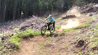
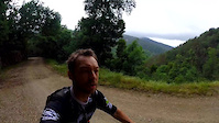
Photos of Coimbra Mountain Bike
Videos of Coimbra Mountain Bike
trail: Barragem Vila Nova
0:04 |
9 |
May 8, 2022
trail: Barraca Preta
0:17 |
78 |
Aug 2, 2021
trail: Barraca Preta
0:57 |
52 |
Nov 13, 2020
trail: DH3
2:07 |
71 |
Jan 21, 2020
trail: Lorvao Enduro
10:29 |
69 |
May 22, 2017
trail: DH3
4:15 |
130 |
Dec 1, 2016
trail: Aveleira-Lorvão DH
0:26 |
3883 |
Mar 31, 2016
trail: DH3
4:44 |
102 |
Feb 6, 2016
Current Trail Warnings
| status | trail | date | condition | user | info |
|---|---|---|---|---|---|
| Interminável Lousã | Jun 5, 2026 @ 9:57am (Europe/Lisbon) Jun 5, 2026 | Dry | Spectralon | ||
| EN4 Louzanpark | May 31, 2026 @ 8:48am (Europe/Lisbon) May 31, 2026 | Dry | muska10 | E-Bike Trail closed, needs a lot of work... | |
| EN3 Louzanpark | May 31, 2026 @ 8:46am (Europe/Lisbon) May 31, 2026 | Dry | muska10 | E-Bike Bottom half completely closed and... |
Recent Trail Reports
| status | trail | date | condition | info | user |
|---|---|---|---|---|---|
| EN6 Louzanpark | Jun 13, 2026 @ 11:48pm (Europe/Lisbon) Jun 13, 2026 | Dry | stifmanenc | ||
| EN7 Louzanpark | Jun 13, 2026 @ 11:46pm (Europe/Lisbon) Jun 13, 2026 | Dry | stifmanenc | ||
| Funtrack Serra da Boa Viagem | Jun 6, 2026 @ 10:02am (Europe/Lisbon) Jun 6, 2026 | Ideal | stifmanenc | ||
| Abrigo Serra da Boa Viagem | Jun 2, 2026 @ 11:32pm (Europe/Lisbon) Jun 2, 2026 | Ideal | Yurii1 | ||
| Zero Lítio Serra da Boa Viagem | Jun 2, 2026 @ 11:30pm (Europe/Lisbon) Jun 2, 2026 | Ideal | Yurii1 | ||
| Parque Aventura Serra da Boa Viagem | Jun 2, 2026 @ 11:27pm (Europe/Lisbon) Jun 2, 2026 | Ideal | Yurii1 | ||
| Aveleira 1 Lorvão | May 17, 2026 @ 10:21am (Europe/Lisbon) May 17, 2026 | Variable | mexicanoportugal | ||
| Aveleira 2 Lorvão | May 17, 2026 @ 10:21am (Europe/Lisbon) May 17, 2026 | Variable | mexicanoportugal | ||
| Avalanche Serra da Lousã | Apr 3, 2026 @ 11:51am (Europe/Lisbon) Apr 3, 2026 | Dry | Fiti098 | ||
| Avalanche Superior Serra da Lousã | Apr 3, 2026 @ 11:51am (Europe/Lisbon) Apr 3, 2026 | Very Dry | Fiti098 |
Activity Feed
| username | action | type | title | date |
|---|---|---|---|---|
| Sabinew2mWkD | ridden | trail | activity #97203132 | Jun 17, 2026 @ 12:30pm 2 days |
| Sabinew2mWkD | add | photo | activity #97203094 and 4 more | Jun 17, 2026 @ 12:29pm 2 days |
| Sabinew2mWkD | ridden | trail | activity #97203034 and 1 more | Jun 17, 2026 @ 12:28pm 2 days |
| Sabinew2mWkD | comment | trail | activity #97202718 | Jun 17, 2026 @ 12:24pm 2 days |
| Sabinew2mWkD | add | photo | activity #97186804 and 1 more | Jun 17, 2026 @ 8:44am 2 days |
Recent Comments
| username | type | title | comment | date |
|---|---|---|---|---|
| trail | Attention: The trail is actually undriveble;... | Jun 17, 2026 @ 12:24pm 2 days | ||
| trail | I liked it. But after the last pin there are... | Jun 2, 2026 @ 3:39pm Jun 2, 2026 | ||
| trail | Liked it | Jun 2, 2026 @ 3:35pm Jun 2, 2026 | ||
| trail | Liked it | Jun 2, 2026 @ 3:34pm Jun 2, 2026 | ||
| trail | Liked it | Jun 2, 2026 @ 3:32pm Jun 2, 2026 |
Local Badges
-

Big Ride 30k397 awarded -

Completionist0 awarded -

Top 10 Trails0 awarded -

Epic Ride 50k154 awarded -
Epic Ride 50k47 awarded -

Descent 100k Badge0 awarded
Bike & Skill Parks
| name | type | city | rating |
|---|---|---|---|
| Louzanpark | bike park | Lousã |
Activity Type Stats
| activitytype | trails | distance | descent | descent distance | total vertical | rating | global rank | state rank | photos | reports | routes | ridelogs |
|---|---|---|---|---|---|---|---|---|---|---|---|---|
| Mountain Bike | 118 | 73 miles | 33,533 ft | 47 miles | 3,658 ft | 827 | 229 | 4 | 9,408 | |||
| E-Bike | 79 | 41 miles | 18,488 ft | 28 miles | 3,658 ft | 191 | 1,666 | |||||
| Hike | 94 | 52 miles | 23,333 ft | 35 miles | 3,658 ft | 199 | 1 | 1,004 | ||||
| Trail Running | 104 | 59 miles | 27,917 ft | 41 miles | 3,658 ft | 217 | 1 | 145 | ||||
| Dirtbike/Moto | 1 | 1 mile | 791 ft | 1 mile | 787 ft | 15 | ||||||
| ATV/ORV/OHV | 3 | 7 miles | 92 ft | 3,192 ft | 2,543 ft | 12 |
Activities
Trails
- By brenthillier
 NSMBA TRAILFORKS & contributors
 - Admins: elyari, AMG, marcossantamaria, ATBV
- #9885 - 7,610 views
- coimbra activity log | embed map of Coimbra mountain bike trails | coimbra mountain biking points of interest
Downloading of trail gps tracks in kml & gpx formats is enabled for Coimbra.
You must login to download files.