close
-
Layers w
- Weather Layers
- Pro
- Pro
- Pro
- Pro
- Pro
- Pro
- More Layers
- Pro
- Pro
- Pro
- Pro
-
Upgrade to

3D
Trail Conditions
- Unknown
- Snow Groomed
- Snow Packed
- Snow Covered
- Snow Cover Partial
- Freeze/thaw Cycle
- Icy
- Prevalent Mud
- Wet
- Variable
- Ideal
- Dry
- Very Dry
Trail Flow (Ridden Direction)
Trailforks scans users ridelogs to determine the most popular direction each trail is ridden. A good flowing trail network will have most trails flowing in a single direction according to their intension.
The colour categories are based on what percentage of riders are riding a trail in its intended direction.
The colour categories are based on what percentage of riders are riding a trail in its intended direction.
- > 96%
- > 90%
- > 80%
- > 70%
- > 50%
- < 50%
- bi-directional trail
- no data
Trail Last Ridden
Trailforks scans ridelogs to determine the last time a trail was ridden.
- < 2 days
- < 1 week
- < 2 weeks
- < 1 month
- < 6 months
- > 6 months
Trail Ridden Direction
The intended direction a trail should be ridden.
- Downhill Only
- Downhill Primary
- Both Directions
- Uphill Primary
- Uphill Only
- One Direction
Contribute Details
Colors indicate trail is missing specified detail.
- Description
- Photos
- Description & Photos
- Videos
Trail Popularity ?
Trailforks scans ridelogs to determine which trails are ridden the most in the last 9 months.
Trails are compared with nearby trails in the same city region with a possible 25 colour shades.
Think of this as a heatmap, more rides = more kinetic energy = warmer colors.
- most popular
- popular
- less popular
- not popular
ATV/ORV/OHV Filter
Max Vehicle Width
inches
US Cell Coverage
Legend

Radar Time
Activity Recordings
Trailforks uses anonymized public activity data.
?
Activity Recordings
Trailforks uses anonymized public activity data.
?
Personal Heatmap
▶
Activity Types
all
/
none
▶
Options
2
Date range
month
–
Winter Trails
Warning
A routing network for winter maps does not exist. Selecting trails using the winter trails layer has been disabled.
Missing Trails
Most Popular
Least Popular
Trails are colored based on popularity. The more popular a trail is, the more red. Less popular trails trend towards green.
Jump Magnitude Heatmap
Heatmap of where riders jump on trails. Zoom in to see individual jumps, click circles to view jump details.
BC Backroad Status
![map legend]()
Service Road Atlas is a free to use, community-driven service for viewing and creating reports on the numerous back-country service roads around B.C. and Alberta.

Slope Aspect
Direction the slope faces
Trails Deemphasized
Trails are shown in grey.
Only show trails with no bike usage.
Suggested Layers
Based on selected activity type
Save the current map location and zoom level as your default home location whenever this page is loaded.
Save
No description for Coleman has been added yet!
Login or register to submit one.
Activities Click to view
- Mountain Bike
101 trails
- E-Bike
96 trails
- Gravel Bike
11 trails
- Adaptive Bike
0 trails
- Horse
30 trails
- Hike
103 trails
- Trail Running
99 trails
- Snowshoe
71 trails
- Backcountry Ski
27 trails
- Nordic Ski
32 trails
Region Details
- 17
- 1
- 19
- 58
- 6
Region Status
Open as of 3 daysStats
- Avg Trail Rating
- Trails (view details)
- 113
- Trails Mountain Bike
- 101
- Trails E-Bike
- 96
- Trails Gravel Bike
- 11
- Trails Horse
- 30
- Trails Hike
- 103
- Trails Trail Running
- 99
- Trails Dirtbike/Moto
- 4
- Trails Observed Trials
- 1
- Trails ATV/ORV/OHV
- 3
- Trails Snowmobile
- 3
- Trails Snowshoe
- 71
- Trails Backcountry Ski
- 27
- Trails Nordic Ski
- 32
- Total Distance
- 120 miles
- Total Descent
- 17,173 ft
- Total Vertical
- 4,937 ft
- Highest Trailhead
- 9,247 ft
- Reports
- 1,072
- Photos
- 476
- Ridden Counter
- 17,221
Sub Regions
-
Allison-Chinook Provincial Recreation Area
- 10
- 25
-
Nez Perce
- 2
- 4
- 2
-
York Creek
- 1
- 14
- 4
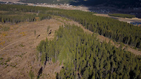
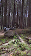
Popular Coleman Mountain Biking Trails
• 100 ★ 4.9 • 1 mile • 0 ft • 1,505 •
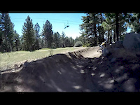
The top half of the trail is full of small-large jumps, bridges, rock features and the signature rock face that you ride down, on stay of the ridge for many challenging rock drops. The bottom half below the cut block has two alternative...
• 100 ★ 4.8 • 2,890 ft • 0 ft • 1,383 •
Flowy, downhill singletrack that starts at the bottom of and/or . Features include a wooden step up, some beautiful berms, and rock features. Singletrack through open forest and across a grassy coal tailings slope. After the open grassy...
• 100 ★ 3.5 • 4,984 ft • 349 ft • 1,253 •
Double-track used to access , Big Bear, and .
• 95 ★ 4.5 • 5,160 ft • 20 ft • 1,007 •
Flowy trail through old forest starting with small berms and jumps, leading into several optional technical features, including gaps, bridge drops and rock drops. Lower section finishes with more flowy and tight switchback single track....
• 95 ★ 5.0 • 1 mile • 93 ft • 914 •
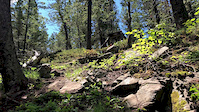
Starting above treeline, the trail meanders through rock and slabs with small drops and steep, loose rock faces to ride down. At tree line it continues to be a steep, technical trail alternating from loose to rock. Near the bottom,...
• 95 ★ 3.8 • 3,136 ft • 230 ft • 802 •
An up trail to take you from the bottom of or to or . Connects with Sooper Connector (turn right for , left for )
• 100 ★ 4.8 • 4,380 ft • 195 ft • 776 •
Single track connecting York Creek Road to 109 to Used to access , , , , , Big Bear, and .
• 90 ★ 4.5 • 2 miles • 758 ft • 616 •
Challenging single track climb to the rocky ridges on top of Saddle Mountain 500 vertical metres above the Crowsnest valley. The middle section is the most difficult, with a narrow bench-cut trail on a steep side-slope and four tight...
Coleman Mountain Bike Routes
★ 4.0 • 8 miles • 1,228 ft • 21 • Loop •
This route accesses three great trails in the northern half of the York Creek trail network, including the...
4 miles • 554 ft • 3 •
From York Creek Staging Area, head north down York Creek Road and turn left on to Sweet Duaneage. If you...
16 miles • 3,136 ft • 9 •
This is the suggested route to hit the five trails for the Jokers Wild poker hand. It does not include the...
★ 5.0 • 15 miles • 2,953 ft • 32 • Loop •
This route covers most of the trails on the hill.
12 miles • 2,223 ft • 8 •
Shred Collective Retirement Ride for York Creek in Crowsnest Pass
★ 1.0 • 13 miles • 3,100 ft • 10 • Loop •
Good loop of the york creek trails that includes Big Bear to Sooper trooper, and School of rock.
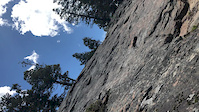
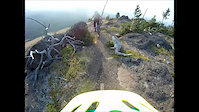
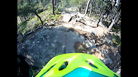
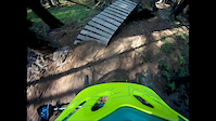
Photos of Coleman Mountain Bike
Videos of Coleman Mountain Bike
trail: School of Rock
0:49 |
66 |
Oct 6, 2021
trail: Sooper Trooper
0:07 |
216 |
Jun 8, 2021
trail: Big Bear Down
9:46 |
223 |
Sep 13, 2020
trail: School of Rock
0:14 |
292 |
Jul 10, 2019
trail: School of Rock
0:08 |
358 |
Jul 10, 2019
trail: Big Bear Down
5:35 |
1458 |
Sep 4, 2017
trail: School of Rock
3:39 |
474 |
Aug 24, 2017
trail: Sooper Trooper
3:31 |
576 |
Aug 12, 2017
Current Trail Warnings
| status | trail | date | condition | user | info |
|---|---|---|---|---|---|
| NRA (lower) | Jun 11, 2026 @ 9:21am (America/Creston) Jun 11, 2026 | Ideal | GuyLag | E-Bike Lots of blowdown |
Recent Trail Reports
Activity Feed
| username | action | type | title | date |
|---|---|---|---|---|
| gmcmorland | wishlist | trail | activity #97277491 and 1 more | Jun 18, 2026 @ 2:53pm 1 day |
| Dpiepgrass | wishlist | route | activity #97223365 | Jun 17, 2026 @ 6:22pm 2 days |
| agoodhue | add | report | activity #97177221 | Jun 17, 2026 @ 5:55am 3 days |
| TylerPierce787 | wishlist | route | activity #97084421 | Jun 15, 2026 @ 8:05pm Jun 15, 2026 |
| dljuden1 | ridden | trail | activity #97071013 | Jun 15, 2026 @ 4:00pm Jun 15, 2026 |
Recent Comments
| username | type | title | comment | date |
|---|---|---|---|---|
| trail | Lower section closed due to logging activity | Sep 22, 2025 @ 8:34am Sep 22, 2025 | ||
| trail | Need to add the fact that this trail is ebike... | Jul 17, 2025 @ 5:53pm Jul 17, 2025 | ||
| trail | Now that it's packed in, this line is amazing.... | Jul 6, 2025 @ 7:15pm Jul 6, 2025 | ||
| trail | Trail has been updated. Jumps are quite... | Jul 5, 2025 @ 7:24pm Jul 5, 2025 | ||
| report | O rrr😆 | Jun 14, 2025 @ 1:30pm Jun 14, 2025 |
Local Badges
-

10 Blue Trails305 awarded -

Epic Ride Climb 2k48 awarded -

Climbing 10k Badge31 awarded -

Climbing 100k Badge3 awarded -

Epic Ride Descent 2k45 awarded -

Descent 10k Badge32 awarded
Activity Type Stats
| activitytype | trails | distance | descent | descent distance | total vertical | rating | global rank | state rank | photos | reports | routes | ridelogs |
|---|---|---|---|---|---|---|---|---|---|---|---|---|
| Mountain Bike | 101 | 107 miles | 16,496 ft | 41 miles | 3,186 ft | #1,505 | #16 | 441 | 1,048 | 13 | 8,524 | |
| E-Bike | 96 | 104 miles | 15,646 ft | 39 miles | 2,795 ft | #854 | #11 | 18 | 868 | 4 | 669 | |
| Gravel Bike | 11 | 27 miles | 2,096 ft | 6 miles | 3,117 ft | #364 | #39 | 29 | 7 | |||
| Horse | 30 | 50 miles | 5,564 ft | 16 miles | 2,723 ft | #1,061 | #12 | 152 | ||||
| Hike | 103 | 116 miles | 16,631 ft | 41 miles | 4,938 ft | #1,815 | #20 | 10 | 1,044 | 2 | 1,315 | |
| Trail Running | 99 | 115 miles | 16,306 ft | 41 miles | 4,938 ft | #1,458 | #18 | 1,044 | 3 | 697 | ||
| Dirtbike/Moto | 4 | 16 miles | 1,706 ft | 5 miles | 2,185 ft | 142 | 63 | |||||
| Observed Trials | 1 | 5 miles | 46 ft | 925 ft | 2,185 ft | 2 | 3 | |||||
| ATV/ORV/OHV | 3 | 15 miles | 1,171 ft | 4 miles | 2,185 ft | 140 | 43 | |||||
| Snowmobile | 3 | 15 miles | 1,171 ft | 4 miles | 2,185 ft | 26 | 9 | |||||
| Snowshoe | 71 | 90 miles | 13,212 ft | 31 miles | 4,938 ft | #60 | #3 | 259 | 2 | 70 | ||
| Backcountry Ski | 27 | 43 miles | 5,312 ft | 15 miles | 2,723 ft | #400 | #11 | 39 | 148 | |||
| Nordic Ski | 32 | 27 miles | 2,182 ft | 8 miles | 2,362 ft | #558 | #15 | 28 | 608 |
Frequently Asked Questions About Coleman
▼
What are the best places to ride in Coleman?
Coleman has 6 areas to explore for mountain biking. The top rated areas are:
▼
What are the highest rated mountain biking trails in Coleman?
The highest rated mountain biking trails in Coleman are:
- School of Rock (4.7/5)
- Big Bear Down (4.6/5)
- Whistling Post (4.5/5)
- Boulder Dash (4.3/5)
- Sweet Duaneage (4.3/5)
▼
What is the best time of the year to ride in Coleman?
Based on ride log data, the most popular months to ride in Coleman are:
- July (391 activities)
- June (252 activities)
- August (238 activities)
▼
Where can I park to ride in Coleman?
There are 8 parking locations listed in Coleman. The most popular parking spots are: View all parking and trailhead locations on the map to plan your visit.
Activities
Trails
Points of Interest
- Peaks to Pints Challenge top of Big Bear (Adult) Summit
- Peaks to Pints Challenge top of School of Rock (Adult) Summit
- Beehive Mountain Summit
- Thunder Mountain Summit
- Waterfall Sight
- Ma Butte Summit
- Saskatoon Mountain Summit
- Crowsnest Mountain Summit
- Alberta-B.B. border Information
- Viewpoint - South Summit
- Tornado Mountain (9,905 ft)
- Mount Lyall (9,652 ft)
- Beehive Mountain (9,360 ft)
- By NMK187
 UROC & contributors
 - Admins: UROC, UROC
- #4046 - 13,867 views
- coleman activity log | embed map of Coleman mountain bike trails | coleman mountain biking points of interest
Downloading of trail gps tracks in kml & gpx formats is enabled for Coleman.
You must login to download files.