close
-
Layers w
- Weather Layers
- Pro
- Pro
- Pro
- Pro
- Pro
- Pro
- More Layers
- Pro
- Pro
- Pro
- Pro
-
Upgrade to

3D
Trail Conditions
- Unknown
- Snow Groomed
- Snow Packed
- Snow Covered
- Snow Cover Partial
- Freeze/thaw Cycle
- Icy
- Prevalent Mud
- Wet
- Variable
- Ideal
- Dry
- Very Dry
Trail Flow (Ridden Direction)
Trailforks scans users ridelogs to determine the most popular direction each trail is ridden. A good flowing trail network will have most trails flowing in a single direction according to their intension.
The colour categories are based on what percentage of riders are riding a trail in its intended direction.
The colour categories are based on what percentage of riders are riding a trail in its intended direction.
- > 96%
- > 90%
- > 80%
- > 70%
- > 50%
- < 50%
- bi-directional trail
- no data
Trail Last Ridden
Trailforks scans ridelogs to determine the last time a trail was ridden.
- < 2 days
- < 1 week
- < 2 weeks
- < 1 month
- < 6 months
- > 6 months
Trail Ridden Direction
The intended direction a trail should be ridden.
- Downhill Only
- Downhill Primary
- Both Directions
- Uphill Primary
- Uphill Only
- One Direction
Contribute Details
Colors indicate trail is missing specified detail.
- Description
- Photos
- Description & Photos
- Videos
Trail Popularity ?
Trailforks scans ridelogs to determine which trails are ridden the most in the last 9 months.
Trails are compared with nearby trails in the same city region with a possible 25 colour shades.
Think of this as a heatmap, more rides = more kinetic energy = warmer colors.
- most popular
- popular
- less popular
- not popular
ATV/ORV/OHV Filter
Max Vehicle Width
inches
US Cell Coverage
Legend

Radar Time
Activity Recordings
Trailforks uses anonymized public activity data.
?
Activity Recordings
Trailforks uses anonymized public activity data.
?
Personal Heatmap
▶
Activity Types
all
/
none
▶
Options
2
Date range
month
–
Winter Trails
Warning
A routing network for winter maps does not exist. Selecting trails using the winter trails layer has been disabled.
Missing Trails
Most Popular
Least Popular
Trails are colored based on popularity. The more popular a trail is, the more red. Less popular trails trend towards green.
Jump Magnitude Heatmap
Heatmap of where riders jump on trails. Zoom in to see individual jumps, click circles to view jump details.
BC Backroad Status
![map legend]()
Service Road Atlas is a free to use, community-driven service for viewing and creating reports on the numerous back-country service roads around B.C. and Alberta.

Slope Aspect
Direction the slope faces
Trails Deemphasized
Trails are shown in grey.
Only show trails with no bike usage.
Suggested Layers
Based on selected activity type
Save the current map location and zoom level as your default home location whenever this page is loaded.
Save
No description for Collegedale has been added yet!
Login or register to submit one.
Activities Click to view
- Mountain Bike
46 trails
- E-Bike
15 trails
- Gravel Bike
0 trails
- Adaptive Bike
0 trails
- Winter Fat Bike
0 trails
- Hike
52 trails
- Trail Running
52 trails
Region Details
- 10
- 11
- 19
- 4
- 2
Region Status
Open as of Jun 15, 2026Stats
- Avg Trail Rating
- Trails (view details)
- 46
- Trails Mountain Bike
- 47
- Trails E-Bike
- 15
- Trails Hike
- 52
- Trails Trail Running
- 52
- Total Distance
- 32 miles
- Total Descent
- 7,506 ft
- Total Vertical
- 509 ft
- Highest Trailhead
- 1,267 ft
- Reports
- 602
- Photos
- 169
- Ridden Counter
- 14,758
Sub Regions
-
Bauxite Ridge
- 3
- 5
-
White Oak Mountain
- 6
- 13
- 4
- 2
Popular Collegedale Mountain Biking Trails
• 95 ★ 3.8 • 3,432 ft • 126 ft • 609 •
Popular green difficulty singletrack. This mountain bike primary trail can be used both directions and has a easy overall physical rating with a 126 ft green climb. On average it takes 4 minutes to complete this trail.
• 75 ★ 5.0 • 2,434 ft • 0 ft • 598 •
One of the top trails of White Oak Mountain! There are many great table-tops along this trail, as well as . With a little bit of skill, these jumps can be cleared no problem. Just make sure you know the trail enough before taking any...
• 70 ★ 4.4 • 2,375 ft • 56 ft • 570 •
This multi-directional trail takes you along several ridgelines on a moderate climb towards the top of the mountain.
• 65 ★ 4.6 • 3,520 ft • 58 ft • 524 •
was recently rebuilt thanks to Barry Smith trails and his crew. It is now one of the top flow trails in the area featuring 25 tabletop jumps and a section of progressive drops! This trail is easily sessionable and the jumps are progressive
• 60 ★ 3.4 • 1 mile • 201 ft • 483 •
Moderately popular green difficulty singletrack. This multi-use trail. On average it takes 10 minutes to complete this trail.
Collegedale Mountain Bike Routes
★ 5.0 • 27 miles • 3,315 ft • 25 •
Full tour of every trail at white oak and bauxite trails
★ 3.0 • 11 miles • 997 ft • 9 • Loop •
This intermediate loop showcases the depth and range of the SAU Biology Trails while keeping the ride...
10 miles • 822 ft • 5 •
Start from the new parking area (with restrooms) and roll directly into Loop clockwise to warm up on...
4 miles • 287 ft • 11 • Loop •
This 4-mile loop offers a smooth, scenic introduction to White Oak Mountain’s trail network. Linking , ,...
14 miles • 2,138 ft • 14 • Loop •
For experienced riders ready to tackle everything White Oak has to offer. This full-mountain route links...
5 miles • 1,015 ft • 6 •
We are going to head to Collegedale for my 35th Bday! This is the route we will be riding.
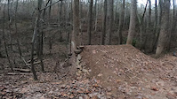
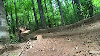
Photos of Collegedale Mountain Bike
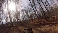
Videos of Collegedale Mountain Bike
trail: Cottontail
0:07 |
|
Nov 18, 2022
trail: Cottontail
0:10 |
217 |
May 25, 2022

trail: Upper Nutty Buddy
6:39 |
120 |
Mar 17, 2021

trail: Upper Nutty Buddy
7:04 |
178 |
May 9, 2020

trail: Summer
0:28 |
587 |
May 1, 2016
trail: Cottontail
8:36 |
554 |
Apr 2, 2014
trail: Summer
0:32 |
150 |
Mar 9, 2014

trail: Valley
0:36 |
212 |
Dec 2, 2013
Recent Trail Reports
| status | trail | date | condition | info | user |
|---|---|---|---|---|---|
| Oak Hole Lane | Jun 15, 2026 @ 5:02pm (America/New_York) Jun 15, 2026 | Unknown | Punmaster9000 | ||
| Mindbender | Jun 9, 2026 @ 7:34pm (America/Kentucky/Monticello) Jun 9, 2026 | Variable | trailadventurer | ||
| Box Turtle | Jun 9, 2026 @ 7:34pm (America/Kentucky/Monticello) Jun 9, 2026 | Variable | trailadventurer | ||
| Mid Ridge | Apr 30, 2026 @ 2:11pm (America/New_York) Apr 30, 2026 | Unknown | umj54 | ||
| North Side Climb Trail | Apr 30, 2026 @ 1:59pm (America/New_York) Apr 30, 2026 | Unknown | umj54 | ||
| Krebs Cycle | Apr 30, 2026 @ 1:36pm (America/New_York) Apr 30, 2026 | Unknown | umj54 | ||
| Forest Lane | Mar 27, 2026 @ 4:15pm (America/Kentucky/Monticello) Mar 27, 2026 | Ideal | trailadventurer | ||
| Lower Nutty Buddy | Mar 23, 2026 @ 6:04pm (America/Kentucky/Monticello) Mar 23, 2026 | Ideal | trailadventurer | ||
| Dogwood | Mar 23, 2026 @ 6:04pm (America/Kentucky/Monticello) Mar 23, 2026 | Ideal | trailadventurer | ||
| Murky Marsh Pogo Connector | Feb 20, 2026 @ 2:45pm (America/New_York) Feb 20, 2026 | Ideal | MasonRaker |
Activity Feed
| username | action | type | title | date |
|---|---|---|---|---|
| DankerSix5 | wishlist | region | activity #97214116 | Jun 17, 2026 @ 3:52pm 1 day |
| Punmaster9000 | add | report | activity #97064318 | Jun 15, 2026 @ 2:02pm Jun 15, 2026 |
| Punmaster9000 | ridden | trail | activity #97064191 | Jun 15, 2026 @ 2:00pm Jun 15, 2026 |
| Gary9TS3M | wishlist | region | activity #96973583 | Jun 14, 2026 @ 8:46am Jun 14, 2026 |
| TrippiL7gAO | wishlist | trail | activity #96752652 | Jun 11, 2026 @ 11:47am Jun 11, 2026 |
Recent Comments
| username | type | title | comment | date |
|---|---|---|---|---|
| report | Boxturtle is a very fun trail that anyone can ride | Feb 23, 2026 @ 8:01pm Feb 23, 2026 | ||
| trail | Fun. This whole block of trails are all... | Jul 22, 2025 @ 5:28pm Jul 22, 2025 | ||
| report | A Major League k m | Jul 10, 2025 @ 12:33pm Jul 10, 2025 | ||
| report | Tree down, partially blocking trail | Jul 10, 2025 @ 6:00am Jul 10, 2025 | ||
| trail | Pretty fun, like gimme a brake but easier | Apr 20, 2025 @ 2:46pm Apr 20, 2025 |
Local Badges
-

10 Blue Trails247 awarded -

Epic Ride Climb 2k5 awarded -

Climbing 10k Badge96 awarded -

Climbing 100k Badge1 awarded -

Epic Ride Descent 2k5 awarded -

Descent 10k Badge98 awarded
Activity Type Stats
| activitytype | trails | distance | descent | descent distance | total vertical | rating | global rank | state rank | photos | reports | routes | ridelogs |
|---|---|---|---|---|---|---|---|---|---|---|---|---|
| Mountain Bike | 46 | 32 miles | 7,507 ft | 16 miles | 509 ft | #1,183 | #457 | 168 | 602 | 6 | 18,980 | |
| E-Bike | 15 | 3 miles | 594 ft | 2 miles | 384 ft | #6,919 | #2,077 | 1 | 498 | 1 | 765 | |
| Hike | 52 | 30 miles | 6,952 ft | 14 miles | 509 ft | #5,606 | #1,971 | 1 | 584 | 721 | ||
| Trail Running | 52 | 30 miles | 6,952 ft | 14 miles | 509 ft | #5,181 | #1,624 | 584 | 1,094 |
Frequently Asked Questions About Collegedale
▼
What are the best places to ride in Collegedale?
Collegedale has 3 areas to explore for mountain biking. The top rated areas are:
▼
What are the highest rated mountain biking trails in Collegedale?
The highest rated mountain biking trails in Collegedale are:
- Upper Nutty Buddy (4.6/5)
- Murky Marsh (4.4/5)
- Cottontail (4.4/5)
- Box Turtle (4.4/5)
- Pine (4.3/5)
▼
What is the best time of the year to ride in Collegedale?
Based on ride log data, the most popular months to ride in Collegedale are:
- July (100 activities)
- October (97 activities)
- November (81 activities)
▼
Where can I park to ride in Collegedale?
There are 6 parking locations listed in Collegedale. The most popular parking spots are: View all parking and trailhead locations on the map to plan your visit.
Activities
Trails
Points of Interest
- By NickGator & contributors
- Admins: SORBA Chatt
- #10753 - 5,320 views
- collegedale activity log | embed map of Collegedale mountain bike trails | collegedale mountain biking points of interest
Downloading of trail gps tracks in kml & gpx formats is enabled for Collegedale.
You must login to download files.