close
-
Layers w
- Weather Layers
- Pro
- Pro
- Pro
- Pro
- Pro
- Pro
- More Layers
- Pro
- Pro
- Pro
- Pro
-
Upgrade to

3D
Trail Conditions
- Unknown
- Snow Groomed
- Snow Packed
- Snow Covered
- Snow Cover Partial
- Freeze/thaw Cycle
- Icy
- Prevalent Mud
- Wet
- Variable
- Ideal
- Dry
- Very Dry
Trail Flow (Ridden Direction)
Trailforks scans users ridelogs to determine the most popular direction each trail is ridden. A good flowing trail network will have most trails flowing in a single direction according to their intension.
The colour categories are based on what percentage of riders are riding a trail in its intended direction.
The colour categories are based on what percentage of riders are riding a trail in its intended direction.
- > 96%
- > 90%
- > 80%
- > 70%
- > 50%
- < 50%
- bi-directional trail
- no data
Trail Last Ridden
Trailforks scans ridelogs to determine the last time a trail was ridden.
- < 2 days
- < 1 week
- < 2 weeks
- < 1 month
- < 6 months
- > 6 months
Trail Ridden Direction
The intended direction a trail should be ridden.
- Downhill Only
- Downhill Primary
- Both Directions
- Uphill Primary
- Uphill Only
- One Direction
Contribute Details
Colors indicate trail is missing specified detail.
- Description
- Photos
- Description & Photos
- Videos
Trail Popularity ?
Trailforks scans ridelogs to determine which trails are ridden the most in the last 9 months.
Trails are compared with nearby trails in the same city region with a possible 25 colour shades.
Think of this as a heatmap, more rides = more kinetic energy = warmer colors.
- most popular
- popular
- less popular
- not popular
ATV/ORV/OHV Filter
Max Vehicle Width
inches
US Cell Coverage
Legend

Radar Time
Activity Recordings
Trailforks uses anonymized public activity data.
?
Activity Recordings
Trailforks uses anonymized public activity data.
?
Personal Heatmap
▶
Activity Types
all
/
none
▶
Options
2
Date range
month
–
Winter Trails
Warning
A routing network for winter maps does not exist. Selecting trails using the winter trails layer has been disabled.
Missing Trails
Most Popular
Least Popular
Trails are colored based on popularity. The more popular a trail is, the more red. Less popular trails trend towards green.
Jump Magnitude Heatmap
Heatmap of where riders jump on trails. Zoom in to see individual jumps, click circles to view jump details.
BC Backroad Status
![map legend]()
Service Road Atlas is a free to use, community-driven service for viewing and creating reports on the numerous back-country service roads around B.C. and Alberta.

Slope Aspect
Direction the slope faces
Trails Deemphasized
Trails are shown in grey.
Only show trails with no bike usage.
Suggested Layers
Based on selected activity type
Save the current map location and zoom level as your default home location whenever this page is loaded.
Save
No description for Columbia has been added yet!
Login or register to submit one.
Activities Click to view
- Mountain Bike
70 trails
- E-Bike
23 trails
- Adaptive Bike
1 trails
- Winter Fat Bike
0 trails
- Horse
14 trails
- Hike
89 trails
- Trail Running
90 trails
- Dirtbike/Moto
0 trails
- ATV/ORV/OHV
0 trails
- Snowmobile
0 trails
- Snowshoe
10 trails
- Downhill Ski
0 trails
- Backcountry Ski
0 trails
- Nordic Ski
1 trails
Region Details
- 10
- 4
- 22
- 26
- 2
- 2
Region Status
Caution as of May 5, 2026Stats
- Avg Trail Rating
- Trails (view details)
- 79
- Trails Mountain Bike
- 77
- Trails E-Bike
- 23
- Trails Gravel Bike
- 2
- Trails Adaptive Bike
- 1
- Trails Horse
- 14
- Trails Hike
- 90
- Trails Trail Running
- 90
- Trails Snowshoe
- 10
- Trails Nordic Ski
- 1
- Total Distance
- 326 miles
- Total Descent
- 13,967 ft
- Total Vertical
- 465 ft
- Highest Trailhead
- 945 ft
- Reports
- 535
- Photos
- 228
- Ridden Counter
- 3,277
Sub Regions
-
Cosmopolitan Park
- 1
-
Finger Lakes State Park
- 2
- 3
-
Gans Creek Recreation Area
- 2
- 1
-
Grindstone Nature Area
- 3
- 3
- 1
- 1
-
Hart Creek Conservation Area
- 1
-
Hinkson Woods Conservation Area
- 1
-
Little Dixie Lake
-
Mark Twain National Forest - Columbia
- 6
- 1
-
Mizzou Club Cycling Complex
- 2
- 4
- 1
-
Rock Bridge State Park
- 2
- 7
- 4
-
Three Creeks Conservation Area
- 2
- 1
Popular Columbia Mountain Biking Trails
• 95 ★ 4.3 • 5 miles • 547 ft • 128 •
This is a network of tight and twisty turns, rocky sections and narrow gaps between the trees. Best way to learn the trail is ride it with someone familiar with the route. Como Dirtbags have a group ride there some Thursday evenings,...
• 100 ★ 0.0 • 3 miles • 570 ft • 120 •
Popular blue difficulty singletrack. This mountain bike primary trail can be used both directions and has a moderate overall physical rating with a 570 ft black diamond climb. On average it takes 23 minutes to complete this trail.
• 100 ★ 5.0 • 2 miles • 233 ft • 100 •
Popular green difficulty singletrack. This mountain bike primary trail can be used both directions and has a moderate overall physical rating with a 233 ft blue climb. On average it takes 11 minutes to complete this trail.
• 100 ★ 0.0 • 1,998 ft • 0 ft • 93 •
Rooted and rocky downhill from the upper parking lot.
• 75 ★ 0.0 • 864 ft • 15 ft • 91 •
Service road connector to and Rhett's Run Trail
• 90 ★ 0.0 • 1,102 ft • 0 ft • 80 •
Popular green difficulty singletrack. This mountain bike primary trail can be used both directions. On average it takes 1 minutes to complete this trail.
• 90 ★ 5.0 • 613 ft • 3 ft • 72 •
Popular green difficulty singletrack. This mountain bike primary trail can be used both directions and has a easy overall physical rating with a 3 ft green climb. On average it takes minutes to complete this trail.
Columbia Mountain Bike Routes
4 miles • 509 ft • 2 •
This is a 7.3km option for the Rhetts Outdoor Challenge using the current .
4 miles • 535 ft • 2 • Loop •
7km route for the Rhett's Outdoor Challenge (ROC7k), part of a series of trail runs from Columbia Parks...
5 miles • 438 ft • 3 •
This is the preliminary race loop for 2025, pending a reroute of trail from the bridge crossing....
2,654 ft • 26 ft • 0 •
A short loop for the kids event - meant for kids age 4-8. Older kids are encouraged to ride the Junior A...
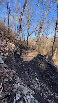
Photos of Columbia Mountain Bike
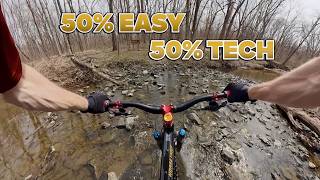
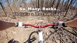
Videos of Columbia Mountain Bike
trail: ExtremeCycles
0:14 |
130 |
Feb 6, 2023

trail: Mizzou Dual Slalom
2:11 |
325 |
Jan 23, 2018
trail: Kelley Branch West Loop
19:46 |
62 |
Apr 9, 2026 , Columbia

trail: Kelley Branch
19:46 |
68 |
Apr 9, 2026 , Columbia

trail: Sinkhole (North)
29:05 |
29 |
Apr 3, 2026 , Columbia

trail: Deer Run Loop
29:05 |
75 |
Apr 3, 2026 , Columbia

trail: Spring Brook
29:05 |
28 |
Apr 3, 2026 , Columbia
trail: Sinkhole
29:05 |
74 |
Apr 3, 2026 , Columbia
Recent Trail Reports
| status | trail | date | condition | info | user |
|---|---|---|---|---|---|
| Sinkhole | May 4, 2026 @ 5:54pm (America/Indiana/Vincennes) May 4, 2026 | Wet | FogeyStogey C2S-TOLT | ||
| Rhett's Run | Mar 20, 2026 @ 7:39am (America/Chicago) Mar 20, 2026 | Ideal | apsbiker COMOTA | ||
| Woodpecker Hollow at Greenbelt Nature Preserve | Mar 20, 2026 @ 6:19am (America/Chicago) Mar 20, 2026 | Ideal | longdukdong | ||
| Kelley Branch | Aug 3, 2025 @ 12:32pm Aug 3, 2025 | Ideal | Richieb82 | ||
| Three Creeks Conservation Area | Jul 9, 2025 @ 12:57pm Jul 9, 2025 | Ideal | apsbiker COMOTA | ||
| Deer Run Loop | Jul 6, 2025 @ 3:57pm Jul 6, 2025 | Wet | apsbiker COMOTA | ||
| Sinkhole (Middle) | Jul 6, 2025 @ 3:57pm Jul 6, 2025 | Wet | apsbiker COMOTA | ||
| Grasslands Access | Jul 6, 2025 @ 3:57pm Jul 6, 2025 | Wet | apsbiker COMOTA | ||
| Paxton passage | Jul 6, 2025 @ 3:57pm Jul 6, 2025 | Wet | apsbiker COMOTA | ||
| Sinkhole (North) | Jul 6, 2025 @ 3:57pm Jul 6, 2025 | Wet | apsbiker COMOTA |
Activity Feed
| username | action | type | title | date |
|---|---|---|---|---|
| NathanKen | ridden | trail | activity #97353350 and 1 more | Jun 19, 2026 @ 4:42pm 3 days |
| NathanKen | ridden | trail | activity #97353327 | Jun 19, 2026 @ 4:42pm 3 days |
| NathanKen | ridden | trail | activity #97353300 | Jun 19, 2026 @ 4:42pm 3 days |
| johnhuebbe | wishlist | route | activity #97123856 | Jun 16, 2026 @ 10:58am Jun 16, 2026 |
| johnhuebbe | ridden | route | activity #97123807 | Jun 16, 2026 @ 10:57am Jun 16, 2026 |
Recent Comments
| username | type | title | comment | date |
|---|---|---|---|---|
| trail | This is a steep rocky road. A serious grunt... | May 5, 2026 @ 2:31pm May 5, 2026 | ||
| trail | We concur. ShakyDog is 100% correct. This... | Aug 31, 2025 @ 2:37pm Aug 31, 2025 | ||
| trail | Why tf are you telling me what Indian tribes... | Aug 26, 2025 @ 8:33am Aug 26, 2025 | ||
| report | Good to ride! | Aug 12, 2024 @ 6:25pm Aug 12, 2024 | ||
| trail | Met the COMO Trail Association Team last... | Aug 12, 2024 @ 6:24pm Aug 12, 2024 |
Local Badges
-

10 Green Trails40 awarded -

10 Blue Trails41 awarded -

Epic Ride Climb 2k33 awarded -

Climbing 10k Badge27 awarded -

Climbing 100k Badge4 awarded -

Epic Ride Descent 2k34 awarded
Bike & Skill Parks
| name | type | city | rating |
|---|---|---|---|
| HLR Motorsports | skill park | Columbia | |
| Finger Lakes MXP Motocross | skill park | Columbia | |
| Hilltop MX | skill park | Columbia |
Local Mountain Biking Directory
-
COMO Trail Association
![COMO Trail Association]()
-
TryathleticsBike Shop
-
Walt's Bike ShopBike Shop
-
Cyclextreme Bicycle WarehouseBike Shop
-
The Alpine Shop - ColumbiaBike Shop
Local Trail Supporters
![]()
- Mizzou Club Cycling
Activity Type Stats
| activitytype | trails | distance | descent | descent distance | total vertical | rating | global rank | state rank | photos | reports | routes | ridelogs |
|---|---|---|---|---|---|---|---|---|---|---|---|---|
| Mountain Bike | 70 | 308 miles | 12,598 ft | 103 miles | 466 ft | #716 | #276 | 214 | 546 | 9 | 12,940 | |
| E-Bike | 23 | 48 miles | 1,106 ft | 22 miles | 341 ft | #2,905 | #1,096 | 106 | 1 | 66 | ||
| Gravel Bike | 2 | #5,409 | #1,767 | 212 | ||||||||
| Adaptive Bike | 1 | #434 | #1,774 | |||||||||
| Horse | 14 | 44 miles | 3,711 ft | 19 miles | 292 ft | #1,116 | #710 | 97 | 2 | |||
| Hike | 89 | 326 miles | 13,967 ft | 109 miles | 466 ft | #564 | #258 | 2 | 606 | 478 | ||
| Trail Running | 90 | 326 miles | 13,967 ft | 109 miles | 466 ft | #409 | #161 | 606 | 2 | 445 | ||
| Snowshoe | 10 | 16 miles | 928 ft | 5 miles | 292 ft | #732 | #322 | 67 | 1 | |||
| Nordic Ski | 1 | 761 ft | 49 ft | 761 ft | 49 ft | #1,093 | #477 | 58 | 11 |
Frequently Asked Questions About Columbia
▼
What are the best places to ride in Columbia?
Columbia has 11 areas to explore for mountain biking. The top rated areas are:
▼
What are the highest rated mountain biking trails in Columbia?
The highest rated mountain biking trails in Columbia are:
- Mizzou Short Track (4.2/5)
- ExtremeCycles (4.2/5)
- Rhett's Run (4.2/5)
- Skills Course (4.1/5)
- South Loop Entrance (4.1/5)
▼
What is the best time of the year to ride in Columbia?
Based on ride log data, the most popular months to ride in Columbia are:
- July (135 activities)
- September (103 activities)
- August (101 activities)
▼
Where can I park to ride in Columbia?
There are 29 parking locations listed in Columbia. The most popular parking spots are: View all parking and trailhead locations on the map to plan your visit.
Activities
Trails
Points of Interest
- By jessem19 & contributors
- Admins: COMOTA
- #6289 - 12,814 views
- columbia activity log | embed map of Columbia mountain bike trails | columbia mountain biking points of interest
Downloading of trail gps tracks in kml & gpx formats is enabled for Columbia.
You must login to download files.