close
-
Layers w
- Weather Layers
- Pro
- Pro
- Pro
- Pro
- Pro
- Pro
- More Layers
- Pro
- Pro
- Pro
- Pro
-
Upgrade to

3D
Trail Conditions
- Unknown
- Snow Groomed
- Snow Packed
- Snow Covered
- Snow Cover Partial
- Freeze/thaw Cycle
- Icy
- Prevalent Mud
- Wet
- Variable
- Ideal
- Dry
- Very Dry
Trail Flow (Ridden Direction)
Trailforks scans users ridelogs to determine the most popular direction each trail is ridden. A good flowing trail network will have most trails flowing in a single direction according to their intension.
The colour categories are based on what percentage of riders are riding a trail in its intended direction.
The colour categories are based on what percentage of riders are riding a trail in its intended direction.
- > 96%
- > 90%
- > 80%
- > 70%
- > 50%
- < 50%
- bi-directional trail
- no data
Trail Last Ridden
Trailforks scans ridelogs to determine the last time a trail was ridden.
- < 2 days
- < 1 week
- < 2 weeks
- < 1 month
- < 6 months
- > 6 months
Trail Ridden Direction
The intended direction a trail should be ridden.
- Downhill Only
- Downhill Primary
- Both Directions
- Uphill Primary
- Uphill Only
- One Direction
Contribute Details
Colors indicate trail is missing specified detail.
- Description
- Photos
- Description & Photos
- Videos
Trail Popularity ?
Trailforks scans ridelogs to determine which trails are ridden the most in the last 9 months.
Trails are compared with nearby trails in the same city region with a possible 25 colour shades.
Think of this as a heatmap, more rides = more kinetic energy = warmer colors.
- most popular
- popular
- less popular
- not popular
ATV/ORV/OHV Filter
Max Vehicle Width
inches
US Cell Coverage
Legend

Radar Time
Activity Recordings
Trailforks uses anonymized public activity data.
?
Activity Recordings
Trailforks uses anonymized public activity data.
?
Personal Heatmap
▶
Activity Types
all
/
none
▶
Options
2
Date range
month
–
Winter Trails
Warning
A routing network for winter maps does not exist. Selecting trails using the winter trails layer has been disabled.
Missing Trails
Most Popular
Least Popular
Trails are colored based on popularity. The more popular a trail is, the more red. Less popular trails trend towards green.
Jump Magnitude Heatmap
Heatmap of where riders jump on trails. Zoom in to see individual jumps, click circles to view jump details.
BC Backroad Status
![map legend]()
Service Road Atlas is a free to use, community-driven service for viewing and creating reports on the numerous back-country service roads around B.C. and Alberta.

Slope Aspect
Direction the slope faces
Trails Deemphasized
Trails are shown in grey.
Only show trails with no bike usage.
Suggested Layers
Based on selected activity type
Save the current map location and zoom level as your default home location whenever this page is loaded.
Save
No description for Conway has been added yet!
Login or register to submit one.
Activities Click to view
- Mountain Bike
9 trails
- Gravel Bike
0 trails
- Adaptive Bike
0 trails
- Hike
9 trails
- Trail Running
9 trails
Region Details
- 4
- 1
- 2
- 2
Region Status
Caution as of Apr 7, 2026Stats
- Avg Trail Rating
- Trails (view details)
- 9
- Trails Mountain Bike
- 9
- Trails E-Bike
- 3
- Trails Hike
- 9
- Trails Trail Running
- 9
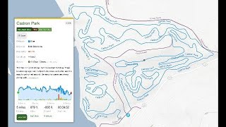
- Total Distance
- 14 miles
- Total Descent
- 1,275 ft
- Total Vertical
- 119 ft
- Highest Trailhead
- 374 ft
- Reports
- 26
- Photos
- 24
- Ridden Counter
- 384
Sub Regions
-
Cadron Park
- 1
Popular Conway Mountain Biking Trails
• 100 ★ 4.5 • 3 miles • 168 ft • 98 •
This trail is a combination of woods and open meadows. Mostly green trail, with some progression built into with easy flowing single track with a few berms and rollers. Very few rocks some roots around one of the ponds. Eventually will...
• 90 ★ 5.0 • 5 miles • 879 ft • 75 •
Short steep climbs, lot's of ups and downs, no sustained climbs, tight and twisty, medium on the technical side, some rock gardens and drops, some skinny's. Lots of bugs and mosquito's.For more information go to...
• 40 ★ 0.0 • 3 miles • 2 ft • 14 •
Moderately popular green difficulty singletrack. This multi-use trail can be used both directions. On average it takes 26 minutes to complete this trail.
• 50 ★ 0.0 • 4,357 ft • 0 ft • 13 •
enter just after the Salem Road Crossing at end of . Cross bridge and turn right. approx 1 mile loop. beginner friendly, family friendly, some roots. ZERO rocks, no climbing. Good for practicing flat cornering practice.
• 80 ★ 2.5 • 2,936 ft • 8 ft • 11 •
This is a flow trail. everything welcome from balance bikes to gravel/mtb. There is a rythym (pump) section , a few beginner level jumps, also a progression of drops 8" and a 3' drop with a go around in between them. The surface is all...
Photos of Conway Mountain Bike
Videos of Conway Mountain Bike

trail: Cadron Park
3:37 |
212 |
Dec 17, 2016
trail: Cadron Park
13:12 |
23 |
Mar 15, 2026 , Conway

trail: Cadron Park
5:53 |
380 |
Jan 1, 2020 , Conway

trail: Cadron Park
6:47 |
506 |
Jan 1, 2020 , Conway
Recent Trail Reports
| status | trail | date | condition | info | user |
|---|---|---|---|---|---|
| Cadron Park | Jun 11, 2024 @ 5:14am Jun 11, 2024 | Ideal | StevetD7dNz | ||
| THE MEADOWS TECH PARK | Mar 17, 2024 @ 4:42pm Mar 17, 2024 | Wet | CodypojMh | ||
| Access Road | Dec 31, 2021 @ 8:14am Dec 31, 2021 | Ideal | BillSwartzwelder |
Activity Feed
| username | action | type | title | date |
|---|---|---|---|---|
| wallaces94 | wishlist | trail | activity #90857566 | Mar 19, 2026 @ 7:52am Mar 19, 2026 |
| P0w3rChi3f | add | video | activity #90662038 | Mar 15, 2026 @ 2:41pm Mar 15, 2026 |
| cybirr | checkin | trail | activity #85749605 | Dec 19, 2025 @ 1:32pm Dec 19, 2025 |
| glytch | wishlist | trail | activity #84010482 | Nov 12, 2025 @ 1:54am Nov 12, 2025 |
| MichaelAreI8R | add | photo | activity #82539775 and 14 more | Oct 17, 2025 @ 6:08pm Oct 17, 2025 |
Recent Comments
| username | type | title | comment | date |
|---|---|---|---|---|
| trail | Nice trail, has a mixed bag of sports for any... | Oct 12, 2025 @ 7:41am Oct 12, 2025 | ||
| trail | Place is nice but you get harassed by a few... | Aug 8, 2025 @ 3:55pm Aug 8, 2025 | ||
| trail | Trail hasn't been maintained in over a year.... | Aug 2, 2025 @ 6:42am Aug 2, 2025 | ||
| trail | Trail is gravel and isn't that great, don't... | Aug 2, 2025 @ 6:41am Aug 2, 2025 | ||
| trail | Cadron Park is a solid trail carved into a... | Jun 11, 2024 @ 2:26pm Jun 11, 2024 |
Local Badges
-

Epic Ride Climb 2k0 awarded -

Climbing 10k Badge8 awarded -

Climbing 100k Badge0 awarded -

Epic Ride Descent 2k0 awarded -

Descent 10k Badge8 awarded -

Descent 100k Badge0 awarded
Local Mountain Biking Directory
-
The RideBike Shop
Activity Type Stats
| activitytype | trails | distance | descent | descent distance | total vertical | rating | global rank | state rank | photos | reports | routes | ridelogs |
|---|---|---|---|---|---|---|---|---|---|---|---|---|
| Mountain Bike | 9 | 14 miles | 1,276 ft | 6 miles | 118 ft | #6,241 | #2,110 | 24 | 26 | 2,508 | ||
| E-Bike | 3 | 7 miles | 223 ft | 3 miles | 102 ft | 18 | 44 | |||||
| Hike | 9 | 14 miles | 1,276 ft | 6 miles | 118 ft | #10,335 | #3,680 | 26 | 45 | |||
| Trail Running | 9 | 14 miles | 1,276 ft | 6 miles | 118 ft | #9,828 | #3,361 | 26 | 27 |
Frequently Asked Questions About Conway
▼
What are the best places to ride in Conway?
Conway has 1 areas to explore for mountain biking. The top rated areas are:
▼
What are the highest rated mountain biking trails in Conway?
The highest rated mountain biking trails in Conway are:
- Cadron Park (4.1/5)
- THE MEADOWS TECH PARK (4.1/5)
- Pompe Park Flow Trail (4/5)
- Tucker Creek Trail (0/5)
- Bunny Slope (0/5)
▼
What is the best time of the year to ride in Conway?
Based on ride log data, the most popular months to ride in Conway are:
- October (32 activities)
- September (24 activities)
- November (18 activities)
▼
Where can I park to ride in Conway?
There are 3 parking locations listed in Conway. The most popular parking spots are: View all parking and trailhead locations on the map to plan your visit.
- By mtbark & contributors
- Admins: CATA
- #13413 - 4,238 views
- conway activity log | embed map of Conway mountain bike trails | conway mountain biking points of interest
Downloading of trail gps tracks in kml & gpx formats is enabled for Conway.
You must login to download files.