close
-
Layers w
- Weather Layers
- Pro
- Pro
- Pro
- Pro
- Pro
- Pro
- More Layers
- Pro
- Pro
- Pro
- Pro
-
Upgrade to

3D
Trail Conditions
- Unknown
- Snow Groomed
- Snow Packed
- Snow Covered
- Snow Cover Partial
- Freeze/thaw Cycle
- Icy
- Prevalent Mud
- Wet
- Variable
- Ideal
- Dry
- Very Dry
Trail Flow (Ridden Direction)
Trailforks scans users ridelogs to determine the most popular direction each trail is ridden. A good flowing trail network will have most trails flowing in a single direction according to their intension.
The colour categories are based on what percentage of riders are riding a trail in its intended direction.
The colour categories are based on what percentage of riders are riding a trail in its intended direction.
- > 96%
- > 90%
- > 80%
- > 70%
- > 50%
- < 50%
- bi-directional trail
- no data
Trail Last Ridden
Trailforks scans ridelogs to determine the last time a trail was ridden.
- < 2 days
- < 1 week
- < 2 weeks
- < 1 month
- < 6 months
- > 6 months
Trail Ridden Direction
The intended direction a trail should be ridden.
- Downhill Only
- Downhill Primary
- Both Directions
- Uphill Primary
- Uphill Only
- One Direction
Contribute Details
Colors indicate trail is missing specified detail.
- Description
- Photos
- Description & Photos
- Videos
Trail Popularity ?
Trailforks scans ridelogs to determine which trails are ridden the most in the last 9 months.
Trails are compared with nearby trails in the same city region with a possible 25 colour shades.
Think of this as a heatmap, more rides = more kinetic energy = warmer colors.
- most popular
- popular
- less popular
- not popular
ATV/ORV/OHV Filter
Max Vehicle Width
inches
US Cell Coverage
Legend

Radar Time
Activity Recordings
Trailforks uses anonymized public activity data.
?
Activity Recordings
Trailforks uses anonymized public activity data.
?
Personal Heatmap
▶
Activity Types
all
/
none
▶
Options
2
Date range
month
–
Winter Trails
Warning
A routing network for winter maps does not exist. Selecting trails using the winter trails layer has been disabled.
Missing Trails
Most Popular
Least Popular
Trails are colored based on popularity. The more popular a trail is, the more red. Less popular trails trend towards green.
Jump Magnitude Heatmap
Heatmap of where riders jump on trails. Zoom in to see individual jumps, click circles to view jump details.
BC Backroad Status
![map legend]()
Service Road Atlas is a free to use, community-driven service for viewing and creating reports on the numerous back-country service roads around B.C. and Alberta.

Slope Aspect
Direction the slope faces
Trails Deemphasized
Trails are shown in grey.
Only show trails with no bike usage.
Suggested Layers
Based on selected activity type
Save the current map location and zoom level as your default home location whenever this page is loaded.
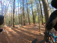
SaveThe Mt. Washington Valley, which incorporates the City of Conway and the sub-division of North Conway, offers a number of diverse and fun mountain bike trails for all levels.
The area is basically divided in two sections - the East Side and the West Side with Rte 16 dividing them.
The East Side trailheads are located in the lower parking lot of Cranmore Fitness, on Thompson Rd. at Pudding Pond and at Hemlock Drive (near Walmart).
The East Side trails can be access from outside Echo Lake State Park Gate, the climbers' parking lot near Cathedral Ledge and at the Marshall Conservation Area on West Side Rd.
AKA: North Conway, Mt Washington Valley
Activities Click to view
- Mountain Bike
195 trails
- E-Bike
42 trails
- Gravel Bike
12 trails
- Adaptive Bike
11 trails
- Winter Fat Bike
46 trails
- Hike
215 trails
- Trail Running
212 trails
- Snowmobile
6 trails
- Snowshoe
70 trails
- Downhill Ski
60 trails
- Backcountry Ski
32 trails
- Nordic Ski
69 trails
Region Details
- 26
- 3
- 73
- 76
- 14
- 2
- 1
Region Status
Open as of Jun 17, 2026Local Trail Association
Stats
- Avg Trail Rating
- Trails (view details)
- 310
- Trails Mountain Bike
- 195
- Trails E-Bike
- 42
- Trails Gravel Bike
- 12
- Trails Adaptive Bike
- 11
- Trails Winter Fat Bike
- 46
- Trails Horse
- 2
- Trails Hike
- 215
- Trails Trail Running
- 212
- Trails Dirtbike/Moto
- 1
- Trails Observed Trials
- 1
- Trails ATV/ORV/OHV
- 1
- Trails Snowmobile
- 6
- Trails Snowshoe
- 70
- Trails Downhill Ski
- 60
- Trails Backcountry Ski
- 32
- Trails Nordic Ski
- 69
- Total Distance
- 243 miles
- Total Descent
- 47,953 ft
- Total Vertical
- 3,024 ft
- Highest Trailhead
- 3,441 ft
- Reports
- 2,910
- Photos
- 316
- Ridden Counter
- 57,947
Sub Regions
-
Cranmore Bike Park (North Conway)
- 5
- 5
- 1
-
East Side Trails (North Conway)
- 1
- 19
- 17
- 3
-
Echo Lake State Park (North Conway)
- 9
- 3
- 5
-
Hurricane Mountain Zone (North Conway)
- 2
- 14
- 4
- 1
- 1
-
Marshall Conservation Area (North Conway)
- 14
- 13
-
Pine Hill
- 1
- 5
- 4
-
West Side (North Conway)
- 8
- 7
- 1
-
Whitaker Woods (North Conway)
- 1
- 12
- 13
Popular Conway Mountain Biking Trails
• 100 ★ 4.2 • 1 mile • 531 ft • 1,513 •
This is primarily a very popular hiking trail. At one point it splits and is signed for hikers only. The last pitches to the summit are not allowed for biking per Nature Conservancy . Please be mindful of hikers when descending.
• 100 ★ 4.4 • 1,328 ft • 74 ft • 1,413 •
Follows along an old with some fun features and old buildings. Named for Steven Swenson, local historian.
• 100 ★ 4.5 • 4,806 ft • 13 ft • 1,357 •
The main trail in the Marshall Conservation Area, mostly machine built. Fast downhill so when ascending keep your eyes open. This is the lower/tighter more technical section.
• 95 ★ 5.0 • 1 mile • 0 ft • 1,340 •
Newly built downhill run with berms, some tabletops and a whole lotta fun. Soft surface so PLEASE AVOID IN WET CONDITIONS. Anything else in North Conway is ok to ride in the wet. If you enjoy this trail please join the WMBC! Your...
• 100 ★ 4.9 • 1 mile • 0 ft • 1,197 •
Fast and pumpy singletrack trail that parallels the old Connector. Turn left at the start of trail to access. Connects with , , and Connector. Combine this with Charlie Dont' Surf for 10 an amazing ten minute descent to the base of ....
• 100 ★ 4.5 • 1,063 ft • 5 ft • 1,183 •
Popular green difficulty singletrack. This multi-use trail can be used both directions. On average it takes 3 minutes to complete this trail.
• 100 ★ 4.0 • 2,264 ft • 96 ft • 1,110 •
Popular green difficulty family friendly singletrack. This multi-use trail can be used both directions and has a easy overall physical rating with a 96 ft green climb. Trail visibility is always easy to follow. On average it takes 4 minutes to complete this trail.
• 100 ★ 4.4 • 2,644 ft • 19 ft • 972 •
Two Way Section of Tornado a Downhill flow trail
Conway Mountain Bike Routes
★ 4.0 • 21 miles • 2,531 ft • 12 • Loop •
west side tour with views from the summit of Whitehorse.
★ 3.8 • 9 miles • 768 ft • 37 •
Nice MtB look from Pudding Pond, the Knot, Swamp, out and back on Swensonout and Cheater, then Pillar to...
9 miles • 973 ft • 7 •
A fun clockwise loop of the Eastside trails in North Conway. Starting chill to warm up on some flatter XC...
8 miles • 1,715 ft • 4 • Loop •
Clockwise route - up , down to the new Tornado trail, and back to the parking lot.
24 miles • 5,765 ft • 10 •
Coming to the Mount Washington Valley for one day? This route will take you on almost all the classic...
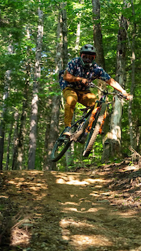
Photos of Conway Mountain Bike
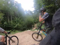
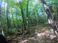
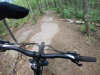
Videos of Conway Mountain Bike
trail: Hurricane
0:20 |
148 |
Aug 8, 2023
trail: Tornado - Upper
5:00 |
100 |
Jul 30, 2022

trail: Tornado - Upper
4:37 |
101 |
Jul 30, 2022
trail: Surf's Up
3:08 |
86 |
Jul 30, 2022
trail: Surf's Up
0:48 |
84 |
Jul 30, 2022
trail: Shumway
7:58 |
156 |
Jul 13, 2022
trail: Holy Cow
2:59 |
89 |
Jul 13, 2022
trail: Link
8:51 |
64 |
May 18, 2022
Current Trail Warnings
| status | trail | date | condition | user | info |
|---|---|---|---|---|---|
| Electric Loop Closed | Jun 10, 2026 @ 10:22pm (America/New_York) Jun 10, 2026 | Unknown | Hubbles83 WMNEMBA | Closed due to Gosshawk nesting expected... | |
| Lower Charlie's | Jun 8, 2026 @ 9:12pm (America/New_York) Jun 8, 2026 | Unknown | ridenoco | Charlie's will be closed for two weeks,... | |
| Charlie's | Jun 8, 2026 @ 9:12pm (America/New_York) Jun 8, 2026 | Unknown | ridenoco | Charlie's will be closed for two weeks,... |
Recent Trail Reports
| status | trail | date | condition | info | user |
|---|---|---|---|---|---|
| Red Tail | Jun 17, 2026 @ 11:13am (America/New_York) Jun 17, 2026 | Variable | JoanneArchambaulteQD | ||
| Black Cap Trail | Jun 17, 2026 @ 11:13am (America/New_York) Jun 17, 2026 | Ideal | JoanneArchambaulteQD | ||
| Echo Lake (East) | Jun 14, 2026 @ 10:40am (America/New_York) Jun 14, 2026 | Ideal | JoanneArchambaulteQD | ||
| Electric Loop | Jun 14, 2026 @ 10:40am (America/New_York) Jun 14, 2026 | Ideal | JoanneArchambaulteQD | ||
| Hale's Location Connector | Jun 14, 2026 @ 10:40am (America/New_York) Jun 14, 2026 | Ideal | JoanneArchambaulteQD | ||
| Echo Lake State Park | Jun 14, 2026 @ 10:40am (America/New_York) Jun 14, 2026 | Ideal | JoanneArchambaulteQD | ||
| Echo Lake State Park | Jun 14, 2026 @ 10:40am (America/New_York) Jun 14, 2026 | Ideal | JoanneArchambaulteQD | ||
| Swenson | Jun 13, 2026 @ 8:35am (America/New_York) Jun 13, 2026 | Dry | lblizzard | ||
| Tornado - Lower | Jun 12, 2026 @ 9:48am (America/New_York) Jun 12, 2026 | Ideal | JoanneArchambaulteQD | ||
| Tornado - Upper | Jun 12, 2026 @ 9:48am (America/New_York) Jun 12, 2026 | Ideal | JoanneArchambaulteQD |
Activity Feed
| username | action | type | title | date |
|---|---|---|---|---|
| rhodyremby | wishlist | route | activity #97292961 | Jun 18, 2026 @ 7:58pm 2 days |
| JoanneArchambaulteQD | add | report | activity #97209054 and 1 more | Jun 17, 2026 @ 2:16pm Jun 17, 2026 |
| gerkenator | add | karma | activity #97124528 | Jun 16, 2026 @ 11:06am Jun 16, 2026 |
| rkoziol1 | wishlist | route | activity #97115277 | Jun 16, 2026 @ 9:09am Jun 16, 2026 |
| scottoneillnh | wishlist | trail | activity #97084681 | Jun 15, 2026 @ 8:12pm Jun 15, 2026 |
Recent Comments
| username | type | title | comment | date |
|---|---|---|---|---|
| trail | anyone know how technical this climb is? can... | May 26, 2026 @ 7:54am May 26, 2026 | ||
| report | Why was the report rejected?, i saw the same... | Dec 8, 2025 @ 3:24am Dec 8, 2025 | ||
| trail | Very fun descending after climbing Outer... | Oct 6, 2025 @ 5:28pm Oct 6, 2025 | ||
| trail | Excellent section of trail. Well-built.... | Oct 6, 2025 @ 5:26pm Oct 6, 2025 | ||
| trail | The recent addition of the final loop segment,... | Sep 7, 2025 @ 4:44pm Sep 7, 2025 |
Local Badges
-

10 Black Trails191 awarded -

Top 10 Trails7 awarded -

Completionist0 awarded -

10 Blue Trails702 awarded -
Completionist0 awarded -
Completionist0 awarded
Bike & Skill Parks
| name | type | city | rating |
|---|---|---|---|
| Cranmore Bike Park (North Conway) | bike park | Conway |
Activity Type Stats
| activitytype | trails | distance | descent | descent distance | total vertical | rating | global rank | state rank | photos | reports | routes | ridelogs |
|---|---|---|---|---|---|---|---|---|---|---|---|---|
| Mountain Bike | 195 | 159 miles | 28,993 ft | 72 miles | 2,749 ft | #379 | #138 | 301 | 2,897 | 40 | 29,978 | |
| E-Bike | 42 | 48 miles | 8,238 ft | 23 miles | 1,568 ft | #2,641 | #1,041 | 1,359 | 2 | 884 | ||
| Gravel Bike | 12 | 16 miles | 1,007 ft | 6 miles | 522 ft | #65 | #768 | 179 | 83 | |||
| Adaptive Bike | 11 | 13 miles | 827 ft | 5 miles | 1,198 ft | #299 | #1,631 | 97 | 1 | |||
| Winter Fat Bike | 46 | 35 miles | 2,680 ft | 11 miles | 2,769 ft | #62 | #876 | 1 | 39 | 30 | ||
| Horse | 2 | 4,951 ft | 49 ft | 1,414 ft | 194 ft | 191 | 2 | |||||
| Hike | 215 | 204 miles | 24,938 ft | 68 miles | 3,025 ft | #677 | #314 | 10 | 2,809 | 3,571 | ||
| Trail Running | 212 | 195 miles | 24,190 ft | 64 miles | 3,025 ft | #622 | #230 | 2,717 | 1,164 | |||
| Dirtbike/Moto | 1 | 1,362 ft | 118 ft | 20 ft | 188 | 5 | ||||||
| Observed Trials | 1 | 1,362 ft | 118 ft | 20 ft | 1 | 5 | ||||||
| ATV/ORV/OHV | 1 | 1,362 ft | 118 ft | 20 ft | 191 | 10 | ||||||
| Snowmobile | 6 | 12 miles | 919 ft | 5 miles | 659 ft | #120 | #57 | 15 | 4 | |||
| Snowshoe | 70 | 37 miles | 4,908 ft | 13 miles | 2,707 ft | #277 | #70 | 120 | 143 | |||
| Downhill Ski | 60 | 15 miles | 14,163 ft | 15 miles | 1,122 ft | #237 | #95 | 1 | 17 | 1,013 | ||
| Backcountry Ski | 32 | 22 miles | 3,606 ft | 8 miles | 2,687 ft | #306 | #52 | 101 | 463 | |||
| Nordic Ski | 69 | 33 miles | 2,126 ft | 11 miles | 279 ft | #389 | #102 | 3 | 112 | 564 |
Frequently Asked Questions About Conway
▼
What are the best places to ride in Conway?
Conway has 14 areas to explore for mountain biking. The top rated areas are:
▼
What are the highest rated mountain biking trails in Conway?
The highest rated mountain biking trails in Conway are:
- Hurricane (4.7/5)
- Surf's Up (4.6/5)
- Charlie's (4.6/5)
- Lower Charlie's (4.6/5)
- Sendero (4.5/5)
▼
What is the best time of the year to ride in Conway?
Based on ride log data, the most popular months to ride in Conway are:
- July (675 activities)
- August (525 activities)
- October (504 activities)
▼
Where can I park to ride in Conway?
There are 26 parking locations listed in Conway. The most popular parking spots are:
- Parking
- Parking
- Thompson Rd Parking
- Parking in Lower Lot of Cranmore Fitness Kiosk
- Old School Lower Parking
Activities
- Conway Mountain Biking Trails
- Conway E-Biking Trails
- Conway Gravel Biking Trails
- Conway Adaptive Biking Trails
- Conway Winter Fat Biking Trails
- Conway Hiking Trails
- Conway Trail Running Trails
- Conway Snowmobiling Trails
- Conway Snowshoeing Trails
- Conway Skiing Trails
- Conway Backcountry Skiing Trails
- Conway Nordic Skiing Trails
Trails
Points of Interest
- White Ledge Lookout Viewpoint
- Peaked Mountain Summit
- Middle Mountain Summit
- Barlett Mountain Summit
- Kearsarge Morth Summit
- Black Cap Summit
- Middle Sister (3,330 ft) Summit
- Mount Chocorua (3,488 ft) Summit
- Last Ledges Viewpoint
- South Moat Mountain (2,761 ft) Summit
- Kearsarge North (3,251 ft)
- Bartlett Mountain (2,579 ft)
- Rickers Knoll (2,464 ft)
- By pfchurchill
 LA VESTA & contributors
 - Admins: WMNEMBA, WMNEMBA, CNH NEMBA, WMNEMBA, MRTC
- #6095 - 40,141 views
- conway activity log | embed map of Conway mountain bike trails | conway mountain biking points of interest polygons
Downloading of trail gps tracks in kml & gpx formats is enabled for Conway.
You must login to download files.