close
-
Layers w
- Weather Layers
- Pro
- Pro
- Pro
- Pro
- Pro
- Pro
- More Layers
- Pro
- Pro
- Pro
- Pro
-
Upgrade to

3D
Trail Conditions
- Unknown
- Snow Groomed
- Snow Packed
- Snow Covered
- Snow Cover Partial
- Freeze/thaw Cycle
- Icy
- Prevalent Mud
- Wet
- Variable
- Ideal
- Dry
- Very Dry
Trail Flow (Ridden Direction)
Trailforks scans users ridelogs to determine the most popular direction each trail is ridden. A good flowing trail network will have most trails flowing in a single direction according to their intension.
The colour categories are based on what percentage of riders are riding a trail in its intended direction.
The colour categories are based on what percentage of riders are riding a trail in its intended direction.
- > 96%
- > 90%
- > 80%
- > 70%
- > 50%
- < 50%
- bi-directional trail
- no data
Trail Last Ridden
Trailforks scans ridelogs to determine the last time a trail was ridden.
- < 2 days
- < 1 week
- < 2 weeks
- < 1 month
- < 6 months
- > 6 months
Trail Ridden Direction
The intended direction a trail should be ridden.
- Downhill Only
- Downhill Primary
- Both Directions
- Uphill Primary
- Uphill Only
- One Direction
Contribute Details
Colors indicate trail is missing specified detail.
- Description
- Photos
- Description & Photos
- Videos
Trail Popularity ?
Trailforks scans ridelogs to determine which trails are ridden the most in the last 9 months.
Trails are compared with nearby trails in the same city region with a possible 25 colour shades.
Think of this as a heatmap, more rides = more kinetic energy = warmer colors.
- most popular
- popular
- less popular
- not popular
ATV/ORV/OHV Filter
Max Vehicle Width
inches
US Cell Coverage
Legend

Radar Time
Activity Recordings
Trailforks uses anonymized public activity data.
?
Activity Recordings
Trailforks uses anonymized public activity data.
?
Personal Heatmap
▶
Activity Types
all
/
none
▶
Options
2
Date range
month
–
Winter Trails
Warning
A routing network for winter maps does not exist. Selecting trails using the winter trails layer has been disabled.
Missing Trails
Most Popular
Least Popular
Trails are colored based on popularity. The more popular a trail is, the more red. Less popular trails trend towards green.
Jump Magnitude Heatmap
Heatmap of where riders jump on trails. Zoom in to see individual jumps, click circles to view jump details.
BC Backroad Status
![map legend]()
Service Road Atlas is a free to use, community-driven service for viewing and creating reports on the numerous back-country service roads around B.C. and Alberta.

Slope Aspect
Direction the slope faces
Trails Deemphasized
Trails are shown in grey.
Only show trails with no bike usage.
Suggested Layers
Based on selected activity type
Save the current map location and zoom level as your default home location whenever this page is loaded.
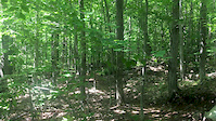
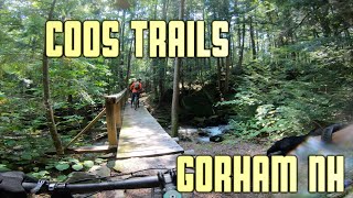
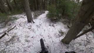
SaveLocated in Gorham, NH, the non-motorized Coös Trails network is open to mountain bikes, trail runners, and hikers. In the winter, select trails are groomed for fat biking and many trails in Moose Brook are popular for snowshoeing and xc ski tours.
The 30+ mile Coös Trails network is incredibly diverse and offers something for everyone. There are three distinct areas of the network that can all be linked together via trail or multi-use corridors. Each area has its own unique character.
Pineside
The most popular trails for mountain biking are located in the area between the town of Gorham and Pine Mountain, locally known as the "Pineside" trails. A mix of hand and machine built trails, these are purpose built for mountain biking and offer everything from scenic flowy "downcountry" on For Pete's Sake to grin inducing black diamond descents on Howie Roll or Baggage Claim . There are great trails here for young and beginner riders, too, with Pumphouse in particular being a universal favorite among any level of rider. The best access point for this area of the network is the Presidential Rail Trail parking lot on Rt. 2, with Big Day Brewing parking lot being an additional option if you're looking specifically for the more advanced downhill trails.
Moose Brook State Park
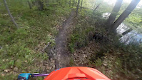
North of the Presidential Rail Trail, The Moose Brook State Park portion of the network features old school New England singletrack. Back to your roots, literally Moose Brook trails feature roots and rock gardens, and are more on the XC tech spectrum of mountain bike trails. That being said there are some great downhill runs as well (Perimeter and Upper Borderline, especially). Perkins Path is one of the most technically challenging trails in the network and also one of the most beautiful. The State Park has its own day use parking area, or you can park at the Rail Trail parking area and ride over from there.
"Pineside" trails and Moose Brook State Park trails can easily be linked together via access on the Presidential Rail Trail and the Hinchey Trail connector.
Power Island
The third area of the network is Power Island which is accessed via the historic rail trestle. You can ride over it on the rail trail (shared with ATVs in the summer) or under it (parking on northbound side of Rt. 16). This area features only two trails, but dries quickly in the spring and is another good option for beginners. You can also ride up to the incredible Mascot Pond from here with a bit of hike a bike on the Mahoosuc trail or ride along the Androscoggin river on Hogan Road (a section of the Cross New Hampshire Adventure Trail) for a great gravel bike outing.
The 30+ mile Coös Trails network is incredibly diverse and offers something for everyone. There are three distinct areas of the network that can all be linked together via trail or multi-use corridors. Each area has its own unique character.
Pineside
The most popular trails for mountain biking are located in the area between the town of Gorham and Pine Mountain, locally known as the "Pineside" trails. A mix of hand and machine built trails, these are purpose built for mountain biking and offer everything from scenic flowy "downcountry" on For Pete's Sake to grin inducing black diamond descents on Howie Roll or Baggage Claim . There are great trails here for young and beginner riders, too, with Pumphouse in particular being a universal favorite among any level of rider. The best access point for this area of the network is the Presidential Rail Trail parking lot on Rt. 2, with Big Day Brewing parking lot being an additional option if you're looking specifically for the more advanced downhill trails.
Moose Brook State Park
North of the Presidential Rail Trail, The Moose Brook State Park portion of the network features old school New England singletrack. Back to your roots, literally Moose Brook trails feature roots and rock gardens, and are more on the XC tech spectrum of mountain bike trails. That being said there are some great downhill runs as well (Perimeter and Upper Borderline, especially). Perkins Path is one of the most technically challenging trails in the network and also one of the most beautiful. The State Park has its own day use parking area, or you can park at the Rail Trail parking area and ride over from there.
"Pineside" trails and Moose Brook State Park trails can easily be linked together via access on the Presidential Rail Trail and the Hinchey Trail connector.
Power Island
The third area of the network is Power Island which is accessed via the historic rail trestle. You can ride over it on the rail trail (shared with ATVs in the summer) or under it (parking on northbound side of Rt. 16). This area features only two trails, but dries quickly in the spring and is another good option for beginners. You can also ride up to the incredible Mascot Pond from here with a bit of hike a bike on the Mahoosuc trail or ride along the Androscoggin river on Hogan Road (a section of the Cross New Hampshire Adventure Trail) for a great gravel bike outing.
source: Moose Brook SP description
Primary Trail Type: Cross-Country
Land Status: Regional Recreation Area
 google parking directions
 Access Info:
Coös Trails Trailhead, Gorham, New Hampshire (aka Presidential Rail Trail Parking)
https://maps.app.goo.gl/pYYXJxDCy7E3m7m17
https://maps.app.goo.gl/pYYXJxDCy7E3m7m17
Links
Activities Click to view
- Mountain Bike
56 trails
- Hike
52 trails
- Trail Running
53 trails
- Snowmobile
8 trails
- Snowshoe
34 trails
- Backcountry Ski
29 trails
- Nordic Ski
4 trails
Region Details
- 6
- 3
- 16
- 21
- 6
- 3
Region Status
Open as of Jun 16, 2026Stats
- Avg Trail Rating
- Trails (view details)
- 57
- Trails Mountain Bike
- 56
- Trails Horse
- 2
- Trails Hike
- 52
- Trails Trail Running
- 53
- Trails Dirtbike/Moto
- 2
- Trails ATV/ORV/OHV
- 3
- Trails Snowmobile
- 8
- Trails Snowshoe
- 34
- Trails Backcountry Ski
- 29
- Trails Nordic Ski
- 4
- Total Distance
- 64 miles
- Total Descent
- 5,299 ft
- Total Vertical
- 1,575 ft
- Highest Trailhead
- 2,357 ft
- Reports
- 651
- Photos
- 226
- Ridden Counter
- 13,877
Popular Coös Trails Mountain Biking Trails
• 95 ★ 4.7 • 1 mile • 19 ft • 871 •
(aka Pete's) is a true Coös classic. This hand-built trail is "downcountry" in nature featuring rolling flow and a nice bermed descent at the end. This trail is technically two way, but is best ridden beginning at Trail and ridden in...
• 90 ★ 4.2 • 1 mile • 109 ft • 737 •
A fun up and down with a mix of tech and flow, hand built but uses a two short sections of the . Great view of Mt. Madison. In winter is groomed for fat bikes, as conditions allow. Look out for snow machines in winter along the east end...
• 100 ★ 4.3 • 3,570 ft • 53 ft • 727 •
A fun flowy trail, is best ridden counter clockwise starting from the Route 2 side of the . Great for beginner riders but fun for all. The loop is approximately 1.5 miles total length and can be tied into other trails in the Pine Mt/...
• 90 ★ 4.4 • 1 mile • 144 ft • 717 •
A beautiful flowy trail along the Moose . Relatively flat, a good option for beginners and kids. Rides well in both directions but most often used to access en-route to In winter is groomed for fat bikes, as conditions allow.
• 95 ★ 5.0 • 3,353 ft • 0 ft • 609 •
A fun flowy trail, Trail is best ridden counter clockwise starting from the Route 2 side of the . Great for beginner riders but fun for all. The loop is approximately 1.5 miles total length and can be tied into other trails in the Pine...
• 85 ★ 5.0 • 3,212 ft • 10 ft • 602 •
A highlight of the network and one of our most popular descent trails. Fast and flowy featuring berms, jumps, shark fins, and a sweet step down to cap it off. Note there is no "mandatory air" thanks to available b-lines and those who...
• 80 ★ 5.0 • 2,477 ft • 12 ft • 523 •
Tight and fast. Sharp turns, small jumps, and big boulder roll over (with B line). One-way, downhill only.
Coös Trails Mountain Bike Routes
★ 3.0 • 13 miles • 1,323 ft • 12 •
The base loop starts on tech old school trails in the state park. The 2nd part takes you to the Pine...
★ 1.0 • 6 miles • 830 ft • 7 •
Ride out on singletrack and climb Perimeter West to the top of Berry Farm Road. Enjoy the downhill on...
Photos of Coös Trails Mountain Bike
Videos of Coös Trails Mountain Bike
trail: Upper Borderline
0:06 |
93 |
Jul 27, 2020
trail: River Trail
2:13 |
257 |
May 22, 2015

6:10 |
145 |
Sep 24, 2023
3:29 |
210 |
Sep 13, 2023
trail: Middle PiMo Enduro
4:18 |
286 |
Jan 5, 2023 , Gorham

trail: Lord Of The Flies
3:01 |
1026 |
Jul 25, 2021 , Gorham

trail: Howie Roll
3:51 |
725 |
Jul 5, 2021 , Gorham

trail: Carry On
3:00 |
414 |
Jun 12, 2021 , Gorham
Recent Trail Reports
| status | trail | date | condition | info | user |
|---|---|---|---|---|---|
| Pumphouse Loop | Jun 16, 2026 @ 12:56pm (America/New_York) Jun 16, 2026 | Ideal | JoanneArchambaulteQD | ||
| Power Island Loop | Jun 16, 2026 @ 12:56pm (America/New_York) Jun 16, 2026 | Ideal | JoanneArchambaulteQD | ||
| Undermine Loop | Jun 16, 2026 @ 12:56pm (America/New_York) Jun 16, 2026 | Ideal | JoanneArchambaulteQD | ||
| Alpine Spring | Jun 10, 2026 @ 10:20am (America/New_York) Jun 10, 2026 | Ideal | JoanneArchambaulteQD | ||
| Carry On | Jun 10, 2026 @ 10:20am (America/New_York) Jun 10, 2026 | Ideal | JoanneArchambaulteQD | ||
| Pumphouse Loop | Jun 10, 2026 @ 10:20am (America/New_York) Jun 10, 2026 | Ideal | JoanneArchambaulteQD | ||
| For Pete's Sake | May 27, 2026 @ 1:38pm (America/New_York) May 27, 2026 | Ideal | JoanneArchambaulteQD | ||
| Blast Pad | May 27, 2026 @ 1:38pm (America/New_York) May 27, 2026 | Ideal | JoanneArchambaulteQD | ||
| DHT | Apr 29, 2026 @ 1:44pm (America/New_York) Apr 29, 2026 | Variable | peter-rabbit-mtb CCC | ||
| Upper Borderline | Apr 29, 2026 @ 1:43pm (America/New_York) Apr 29, 2026 | Variable | peter-rabbit-mtb CCC |
Activity Feed
| username | action | type | title | date |
|---|---|---|---|---|
| JoanneArchambaulteQD | add | report | activity #97137234 and 2 more | Jun 16, 2026 @ 2:13pm Jun 16, 2026 |
| JoanneArchambaulteQD | add | report | activity #96733186 and 2 more | Jun 11, 2026 @ 6:30am Jun 11, 2026 |
| MichaelJBzz | wishlist | trail | activity #96507636 | Jun 7, 2026 @ 4:43pm Jun 7, 2026 |
| daisies | wishlist | region | activity #96466379 | Jun 7, 2026 @ 8:50am Jun 7, 2026 |
| JoanneArchambaulteQD | add | report | activity #95655712 and 3 more | May 27, 2026 @ 12:50pm May 27, 2026 |
Recent Comments
| username | type | title | comment | date |
|---|---|---|---|---|
| report | Tree cleared. Thank you for the report. | Apr 29, 2026 @ 10:40am Apr 29, 2026 | ||
| trail | About as close to a backcountry flow trail as... | Oct 27, 2025 @ 7:38am Oct 27, 2025 | ||
| trail | Great trail! 7/27/2025: beware of a ground... | Jul 27, 2025 @ 7:49pm Jul 27, 2025 | ||
| report | The last 100 yards or so before the perimeter... | Aug 23, 2024 @ 7:42am Aug 23, 2024 | ||
| trail | Great trail. Some good fun jumps. | Aug 18, 2024 @ 12:33pm Aug 18, 2024 |
Nearby Areas
| name | distance | ||||
|---|---|---|---|---|---|
| Jericho Mountain | 19 | 17 | 2 | 6.9 km | |
| Great Glen Trails | 16 | 7 | 3 | 7.3 km | |
| Trail Pool -White Mountain National Forest | 9.2 km | ||||
| Highwater | 1 | 12.1 km | |||
| Rail Trail | 12.2 km |
Local Badges
-

Completionist0 awarded
Local Trail Supporters
- https://cooscyclingclub.org/
![]()
Activity Type Stats
| activitytype | trails | distance | descent | descent distance | total vertical | rating | global rank | state rank | photos | reports | routes | ridelogs |
|---|---|---|---|---|---|---|---|---|---|---|---|---|
| Mountain Bike | 56 | 57 miles | 4,551 ft | 22 miles | 1,385 ft | #1,233 | #423 | 168 | 651 | 4 | 4,985 | |
| Horse | 2 | 19 miles | 719 ft | 10 miles | 692 ft | 78 | ||||||
| Hike | 52 | 56 miles | 4,068 ft | 21 miles | 1,493 ft | #1,830 | #780 | 32 | 637 | 259 | ||
| Trail Running | 53 | 57 miles | 4,370 ft | 21 miles | 1,385 ft | #3,231 | #864 | 1 | 641 | 174 | ||
| Dirtbike/Moto | 2 | 7 miles | 167 ft | 2 miles | 213 ft | 78 | ||||||
| ATV/ORV/OHV | 3 | 13 miles | 896 ft | 4 miles | 1,558 ft | 78 | 10 | |||||
| Snowmobile | 8 | 35 miles | 1,719 ft | 13 miles | 1,558 ft | #23 | #7 | 67 | ||||
| Snowshoe | 34 | 43 miles | 3,852 ft | 19 miles | 1,368 ft | #110 | #31 | 29 | 142 | 18 | ||
| Backcountry Ski | 29 | 23 miles | 2,648 ft | 8 miles | 1,352 ft | #266 | #51 | 126 | 68 | |||
| Nordic Ski | 4 | 25 miles | 719 ft | 10 miles | 768 ft | #607 | #208 | 70 | 19 |
Frequently Asked Questions About Coös Trails
▼
What are the highest rated mountain biking trails in Coös Trails?
The highest rated mountain biking trails in Coös Trails are:
- Howie Roll (4.6/5)
- For Pete's Sake (4.5/5)
- Baggage Claim (4.4/5)
- Carry On (4.4/5)
- Pat Down (4.4/5)
▼
What is the best time of the year to ride in Coös Trails?
Based on ride log data, the most popular months to ride in Coös Trails are:
- August (111 activities)
- July (99 activities)
- September (77 activities)
▼
Where can I park to ride in Coös Trails?
There are 15 parking locations listed in Coös Trails. The most popular parking spots are: View all parking and trailhead locations on the map to plan your visit.
▼
What is the longest trail in Coös Trails?
The longest trail in Coös Trails is Alpine Spring at 2.1 miles. View all trails sorted by distance.
Activities
Trails
- By zurgese CCC & contributors
- Admins: CCC, Adamjl, CCC
- #14961 - 26,002 views
- coös trails activity log | embed map of Coös Trails mountain bike trails | coös trails mountain biking points of interest
Downloading of trail gps tracks in kml & gpx formats is enabled for Coös Trails.
You must login to download files.