close
-
Layers w
- Weather Layers
- Pro
- Pro
- Pro
- Pro
- Pro
- Pro
- More Layers
- Pro
- Pro
- Pro
- Pro
-
Upgrade to

3D
Trail Conditions
- Unknown
- Snow Groomed
- Snow Packed
- Snow Covered
- Snow Cover Partial
- Freeze/thaw Cycle
- Icy
- Prevalent Mud
- Wet
- Variable
- Ideal
- Dry
- Very Dry
Trail Flow (Ridden Direction)
Trailforks scans users ridelogs to determine the most popular direction each trail is ridden. A good flowing trail network will have most trails flowing in a single direction according to their intension.
The colour categories are based on what percentage of riders are riding a trail in its intended direction.
The colour categories are based on what percentage of riders are riding a trail in its intended direction.
- > 96%
- > 90%
- > 80%
- > 70%
- > 50%
- < 50%
- bi-directional trail
- no data
Trail Last Ridden
Trailforks scans ridelogs to determine the last time a trail was ridden.
- < 2 days
- < 1 week
- < 2 weeks
- < 1 month
- < 6 months
- > 6 months
Trail Ridden Direction
The intended direction a trail should be ridden.
- Downhill Only
- Downhill Primary
- Both Directions
- Uphill Primary
- Uphill Only
- One Direction
Contribute Details
Colors indicate trail is missing specified detail.
- Description
- Photos
- Description & Photos
- Videos
Trail Popularity ?
Trailforks scans ridelogs to determine which trails are ridden the most in the last 9 months.
Trails are compared with nearby trails in the same city region with a possible 25 colour shades.
Think of this as a heatmap, more rides = more kinetic energy = warmer colors.
- most popular
- popular
- less popular
- not popular
ATV/ORV/OHV Filter
Max Vehicle Width
inches
US Cell Coverage
Legend

Radar Time
Activity Recordings
Trailforks uses anonymized public activity data.
?
Activity Recordings
Trailforks uses anonymized public activity data.
?
Personal Heatmap
▶
Activity Types
all
/
none
▶
Options
2
Date range
month
–
Winter Trails
Warning
A routing network for winter maps does not exist. Selecting trails using the winter trails layer has been disabled.
Missing Trails
Most Popular
Least Popular
Trails are colored based on popularity. The more popular a trail is, the more red. Less popular trails trend towards green.
Jump Magnitude Heatmap
Heatmap of where riders jump on trails. Zoom in to see individual jumps, click circles to view jump details.
BC Backroad Status
![map legend]()
Service Road Atlas is a free to use, community-driven service for viewing and creating reports on the numerous back-country service roads around B.C. and Alberta.

Slope Aspect
Direction the slope faces
Trails Deemphasized
Trails are shown in grey.
Only show trails with no bike usage.
Suggested Layers
Based on selected activity type
Save the current map location and zoom level as your default home location whenever this page is loaded.
SaveYou like old school? You'll like Copper.
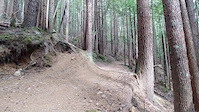
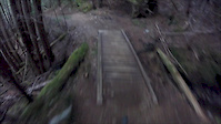
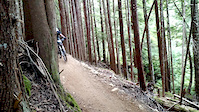
Most of the trails follow the same path as water - straight down the fall line. The trails are a mix of Tech DH and Freeride: steeps, root and rock garden, with the odd bit of flow and lots of hand-built and natural rock structures peppered throughout. Use caution on any and all structures (look before you leap. Maybe look twice or three times before you leap).
Aside from Packhorse, Lick Bike, Lucky Seven and the Thornhill Hiking Trail, the trails on Copper are all unsanctioned. Some of the trails have regular off the grid maintainers, some haven't seen maintenance for several years. Use at your own risk.
Primary Trail Type: All-Mountain & Downhill
Shuttleable: YES
Land Status: Crown Land
Land Manager: Recreation Sites and Trails BC
 google parking directions
 Disclaimer:
Many trails are unsanctioned and unmaintained. Ride at your own Risk!
Activities Click to view
- Mountain Bike
32 trails
- Hike
30 trails
- Trail Running
30 trails
Region Details
- 1
- 2
- 8
- 12
- 4
- 2
Region Status
Caution as of May 22, 2026Stats
- Avg Trail Rating
- Trails (view details)
- 30
- Trails Mountain Bike
- 32
- Trails E-Bike
- 3
- Trails Hike
- 30
- Trails Trail Running
- 30
- Total Distance
- 14 miles
- Total Descent
- 8,749 ft
- Total Vertical
- 4,129 ft
- Highest Trailhead
- 4,839 ft
- Reports
- 325
- Photos
- 108
- Ridden Counter
- 2,409
Popular Copper Mountain Mountain Biking Trails
• 70 ★ 4.2 • 4,268 ft • 0 ft • 272 •
- as is well known from the reports last year, the trail has 4 major debris flows across the trail, rendering it impassable and unsafe with debris and danger trees. The trail has been closed by Rec Sites and Trails BC. If you're...
• 75 ★ 3.9 • 1 mile • 0 ft • 205 •
2021 Update: This trail is in fairly rough condition after several years of extreme weather events. TORCA is currently looking at options for rebuild/reroute. In terms of skill level, some sections are closer to a rowdy, technical...
• 55 ★ 3.5 • 906 ft • 0 ft • 199 •
Single track trail that follows below but is slightly steeper. Crosses several low bridges to cross creeks. The entrance is a bit intimidating but it mellows out right after it.
• 75 ★ 3.2 • 4,207 ft • 391 ft • 190 •
Spur road that turns into a climbing trail half way. Sure beats riding the shuttle road. The spur road section allows access to some lower trails
• 65 ★ 3.0 • 571 ft • 0 ft • 188 •
This trail was rebuilt out of scraps of a trail that was cut down. The log ride is pretty grippy. The woodwork is pretty sketchy. Theres a good little jump and berm at the end.
Leftovers Permanently Closed
• 65 ★ 4.0 • 935 ft • 0 ft • 125 •
Trail starts out off the 4noobs road with a couple tighter bermy corners. If you stay right after the first few berms there is a separate trail with fun jumps but this route tends to be wet and muddy. There's an old log ride on the...
• 60 ★ 4.7 • 3,360 ft • 6 ft • 111 •
Your mom is a wicked good time. Drops and bridges are plentiful and a couple of spicy steep sections get the hair on the back of your neck to stand up. Impressive trail work on and it ends with a long log ride. This trail is reason...
• 55 ★ 0.0 • 528 ft • 0 ft • 102 •
This trail is loamy and narrow with some short steep spots. It has techy flow and ends near the top of Leftovers.
Copper Mountain Mountain Bike Routes
5 miles • 1,652 ft • 39 •
Ride lower trails and maximize your air time and freeride thirst. Add in for and longer experience.
8 miles • 2,702 ft • 49 •
If you are in the area for a good time but not a long time, this route will show you the best copper...
1 mile • 539 ft • 7 •
The maximum amount of gap jumps, hip jumps, step downs, drops, and log rides in the least amount of trail.
7 miles • 2,829 ft • 44 •
The diamond, four expert trails that are arguably the best steep trails on copper mountain.
4 miles • 1,358 ft • 25 •
Ride technical downhill trails with no mandatory airs. Probably the longest time spent descending compared...
• 3 miles • 1,320 ft • 6 •
Photos of Copper Mountain Mountain Bike
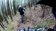
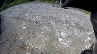
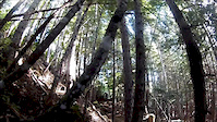
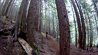
Videos of Copper Mountain Mountain Bike
trail: Packhorse
0:07 |
364 |
Jun 26, 2018
trail: Packhorse
3:46 |
270 |
Aug 10, 2017
trail: Packhorse
0:07 |
313 |
Aug 23, 2015
trail: Leftover
0:15 |
174 |
Sep 18, 2014
trail: Packhorse
0:14 |
282 |
Sep 10, 2014
trail: Packhorse
3:07 |
479 |
Sep 9, 2014
trail: Packhorse
0:41 |
153 |
Aug 14, 2014
trail: Packhorse
0:05 |
169 |
Jul 28, 2014
Recent Trail Reports
| status | trail | date | condition | info | user |
|---|---|---|---|---|---|
| Wade's World | May 22, 2026 @ 8:34pm (America/Vancouver) May 22, 2026 | Variable | jCGIgi | ||
| Packhorse | May 18, 2026 @ 8:35pm (America/Vancouver) May 18, 2026 | Variable | jCGIgi | ||
| Your mom | May 18, 2026 @ 8:33pm (America/Vancouver) May 18, 2026 | Variable | jCGIgi | ||
| Lucky Seven | May 3, 2026 @ 9:21pm (America/Vancouver) May 3, 2026 | Ideal | larissacb TORCA | ||
| Leftovers | Jul 24, 2025 @ 7:23am Jul 24, 2025 | Dry | NO-AIRBAGS | ||
| Send Nudes | Jul 2, 2025 @ 1:21pm Jul 2, 2025 | Variable | NO-AIRBAGS | ||
| Leftovers right line. | Jul 2, 2025 @ 1:19pm Jul 2, 2025 | Unknown | NO-AIRBAGS | ||
| Sexecutioner | Jul 2, 2025 @ 1:18pm Jul 2, 2025 | Unknown | NO-AIRBAGS | ||
| Upgrade | Jul 2, 2025 @ 1:12pm Jul 2, 2025 | Unknown | NO-AIRBAGS | ||
| 4 noobs | Jul 2, 2025 @ 1:10pm Jul 2, 2025 | Variable | NO-AIRBAGS |
Activity Feed
| username | action | type | title | date |
|---|---|---|---|---|
| Gremmen | wishlist | region | activity #95466650 | May 24, 2026 @ 10:41pm May 24, 2026 |
| jCGIgi | add | report | activity #95287614 | May 22, 2026 @ 8:34pm May 22, 2026 |
| jCGIgi | add | report | activity #95019042 and 1 more | May 18, 2026 @ 8:33pm May 18, 2026 |
| trailforks | add | video | activity #94080242 | May 5, 2026 @ 4:00am May 5, 2026 |
| larissacb | add | report | activity #94005801 | May 3, 2026 @ 9:21pm May 3, 2026 |
Recent Comments
| username | type | title | comment | date |
|---|---|---|---|---|
| trail | Incredible track! \m/ | Jun 22, 2025 @ 12:53pm Jun 22, 2025 | ||
| trail | This trail no longer exists due to a massive... | May 14, 2025 @ 3:41pm May 14, 2025 | ||
| trail | Steep and burly, the storm left this trail... | Sep 30, 2024 @ 1:13pm Sep 30, 2024 | ||
| trail | Sept 30, 2024 some minor work to get this one... | Sep 30, 2024 @ 1:11pm Sep 30, 2024 | ||
| trail | Sept 30 2024 lucky this one survived, some... | Sep 30, 2024 @ 1:10pm Sep 30, 2024 |
Nearby Areas
| name | distance | ||||
|---|---|---|---|---|---|
| Terrace Mountain | 7 | 11 | 9 | 1 | 5.9 km |
| Maroon Mountain | 1 | 23.5 km | |||
| Seven Sisters | 1 | 27.8 km | |||
| Oliver Creek | 29.1 km | ||||
| Skeletor | 5 | 5 | 30.9 km |
Local Badges
-

Completionist0 awarded
Activity Type Stats
| activitytype | trails | distance | descent | descent distance | total vertical | rating | global rank | state rank | photos | reports | routes | ridelogs |
|---|---|---|---|---|---|---|---|---|---|---|---|---|
| Mountain Bike | 32 | 10 miles | 8,727 ft | 7 miles | 1,850 ft | #4,958 | #211 | 101 | 325 | 5 | 1,809 | |
| E-Bike | 3 | 2 miles | 1,916 ft | 2 miles | 1,138 ft | 159 | 21 | |||||
| Hike | 30 | 13 miles | 7,162 ft | 6 miles | 4,131 ft | #7,686 | #303 | 7 | 296 | 112 | ||
| Trail Running | 30 | 13 miles | 7,162 ft | 6 miles | 4,131 ft | #6,758 | #250 | 296 | 134 |
Frequently Asked Questions About Copper Mountain
▼
What are the highest rated mountain biking trails in Copper Mountain?
The highest rated mountain biking trails in Copper Mountain are:
- Your mom (4.4/5)
- Big Easy (4.3/5)
- Glade-E8R (4.2/5)
- Body break (4.1/5)
- Buck Wheat (4.1/5)
▼
What is the best time of the year to ride in Copper Mountain?
Based on ride log data, the most popular months to ride in Copper Mountain are:
- June (139 activities)
- July (39 activities)
- August (32 activities)
▼
Where can I park to ride in Copper Mountain?
There are 4 parking locations listed in Copper Mountain. The most popular parking spots are: View all parking and trailhead locations on the map to plan your visit.
▼
What is the longest trail in Copper Mountain?
The longest trail in Copper Mountain is Lucky Seven at 1.1 miles. View all trails sorted by distance.
Activities
- By brenthillier
 NSMBA TRAILFORKS & contributors
 - Admins: TORCA, aleksa, tashpapa, larissacb, NO-AIRBAGS, NBC, PGBRS, aleksa
- #4614 - 14,887 views
- copper mountain activity log | embed map of Copper Mountain mountain bike trails | copper mountain mountain biking points of interest polygons
Downloading of trail gps tracks in kml & gpx formats is enabled for Copper Mountain.
You must login to download files.