close
-
Layers w
- Weather Layers
- Pro
- Pro
- Pro
- Pro
- Pro
- Pro
- More Layers
- Pro
- Pro
- Pro
- Pro
-
Upgrade to

3D
Trail Conditions
- Unknown
- Snow Groomed
- Snow Packed
- Snow Covered
- Snow Cover Partial
- Freeze/thaw Cycle
- Icy
- Prevalent Mud
- Wet
- Variable
- Ideal
- Dry
- Very Dry
Trail Flow (Ridden Direction)
Trailforks scans users ridelogs to determine the most popular direction each trail is ridden. A good flowing trail network will have most trails flowing in a single direction according to their intension.
The colour categories are based on what percentage of riders are riding a trail in its intended direction.
The colour categories are based on what percentage of riders are riding a trail in its intended direction.
- > 96%
- > 90%
- > 80%
- > 70%
- > 50%
- < 50%
- bi-directional trail
- no data
Trail Last Ridden
Trailforks scans ridelogs to determine the last time a trail was ridden.
- < 2 days
- < 1 week
- < 2 weeks
- < 1 month
- < 6 months
- > 6 months
Trail Ridden Direction
The intended direction a trail should be ridden.
- Downhill Only
- Downhill Primary
- Both Directions
- Uphill Primary
- Uphill Only
- One Direction
Contribute Details
Colors indicate trail is missing specified detail.
- Description
- Photos
- Description & Photos
- Videos
Trail Popularity ?
Trailforks scans ridelogs to determine which trails are ridden the most in the last 9 months.
Trails are compared with nearby trails in the same city region with a possible 25 colour shades.
Think of this as a heatmap, more rides = more kinetic energy = warmer colors.
- most popular
- popular
- less popular
- not popular
ATV/ORV/OHV Filter
Max Vehicle Width
inches
US Cell Coverage
Legend

Radar Time
Activity Recordings
Trailforks uses anonymized public activity data.
?
Activity Recordings
Trailforks uses anonymized public activity data.
?
Personal Heatmap
▶
Activity Types
all
/
none
▶
Options
2
Date range
month
–
Winter Trails
Warning
A routing network for winter maps does not exist. Selecting trails using the winter trails layer has been disabled.
Missing Trails
Most Popular
Least Popular
Trails are colored based on popularity. The more popular a trail is, the more red. Less popular trails trend towards green.
Jump Magnitude Heatmap
Heatmap of where riders jump on trails. Zoom in to see individual jumps, click circles to view jump details.
BC Backroad Status
![map legend]()
Service Road Atlas is a free to use, community-driven service for viewing and creating reports on the numerous back-country service roads around B.C. and Alberta.

Slope Aspect
Direction the slope faces
Trails Deemphasized
Trails are shown in grey.
Only show trails with no bike usage.
Suggested Layers
Based on selected activity type
Save the current map location and zoom level as your default home location whenever this page is loaded.
Save
No description for Coppermine has been added yet!
Login or register to submit one.
Primary Trail Type: Cross-Country
AKA: Coppermine
Access Info:
Codgers Trail Centre
Activities Click to view
- Mountain Bike
10 trails
- Hike
17 trails
- Trail Running
20 trails
Region Details
- 3
- 2
Region Status
Open as of Apr 26, 2026Stats
- Avg Trail Rating
- Trails (view details)
- 6
- Trails Mountain Bike
- 10
- Trails E-Bike
- 2
- Trails Hike
- 20
- Trails Trail Running
- 20
- Total Distance
- 30 miles
- Total Descent Distance
- 15 miles
- Total Descent
- 7,946 ft
- Total Vertical
- 2,930 ft
- Highest Trailhead
- 3,087 ft
- Reports
- 196
- Photos
- 190
- Ridden Counter
- 2,115
Popular Coppermine Mountain Biking Trails
• 75 ★ 4.0 • 19 miles • 3,809 ft • 817 •
The is one of New Zealand’s most accessible alpine mountain bike rides, all the more memorable for its relatively easy up, exhilarating down, amazing rocky tops, sweet-smelling beech forest, and meandering river trail. Starting amidst...
• 5 ★ 0.0 • 5,259 ft • 529 ft • 4 • • hike
After leaving , Maitai Cave Track crosses Sclanders Creek (not bridged), which is named after David Sclander, an early Nelson settler involved in the mining of Dun Mountain. The track grade is a step down from the well-maintained , and...
Coppermine Mountain Bike Routes
★ 3.7 • 27 miles • 5,463 ft • 4 • Loop •
This is a bit of a classic Nelson back country loop. This route goes from Brook Street, up to the Dun...
3 miles • 1,108 ft • 1 • Shuttled •
Really nice shorter option to the Nice forest along the undulating ridgeline. Finished with epic views at...
★ 5.0 • 18 miles • 3,882 ft • 0 • Loop •
Loop starting from town and descending Sunrise and peaking Ridge
Photos of Coppermine Mountain Bike
Videos of Coppermine Mountain Bike

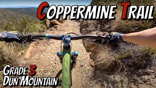
trail: Coppermine Trail
16:53 |
12 |
Jun 3, 2026 , Nelson
trail: Coppermine Trail
35:41 |
471 |
Feb 5, 2024 , Nelson

trail: Coppermine Trail
18:26 |
1040 |
Dec 11, 2020 , Nelson

trail: Coppermine Trail
9:56 |
1029 |
Aug 3, 2019 , Nelson


trail: Coppermine Trail
4:08 |
1352 |
Oct 23, 2018 , Nelson

trail: Coppermine Trail
5:30 |
1307 |
Aug 14, 2018 , Nelson
Recent Trail Reports
| status | trail | date | condition | info | user |
|---|---|---|---|---|---|
| Coppermine Trail | Feb 24, 2026 @ 2:42pm (Pacific/Auckland) Feb 23, 2026 | Ideal | TeTauihutrails | ||
| Brook Waimarama Deviation | Feb 18, 2023 @ 6:43am Feb 18, 2023 | Variable | KiwiDanT | ||
| Connector Trail To Maitai Road | Jan 15, 2023 @ 1:39am Jan 15, 2023 | Ideal | KiwiDanT | ||
| Jenkins Hill Link Trail | Nov 16, 2022 @ 1:20pm Nov 16, 2022 | Unknown | NMTBC NMTBC |
Activity Feed
| username | action | type | title | date |
|---|---|---|---|---|
| ColinKTkNXG | ridden | trail | activity #97726715 | Jun 24, 2026 @ 3:11pm Jun 24, 2026 |
| BelindaqrMuK8 | add | video | activity #96187377 | Jun 3, 2026 @ 4:14pm Jun 3, 2026 |
| omadthedirtyclimber | wishlist | trail | activity #95747878 | May 28, 2026 @ 6:16pm May 28, 2026 |
| xt4lIc | wishlist | trail | activity #94958461 | May 17, 2026 @ 9:04pm May 17, 2026 |
| Bazzabumble | wishlist | trail | activity #94958282 | May 17, 2026 @ 8:53pm May 17, 2026 |
Recent Comments
| username | type | title | comment | date |
|---|---|---|---|---|
| report | Tree has been cleared | Sep 14, 2025 @ 8:04pm Sep 14, 2025 | ||
| report | Will check it out today or tomorrow | Sep 14, 2025 @ 1:17pm Sep 14, 2025 | ||
| report | We will get this tidied up before the weekend. | Jul 8, 2025 @ 5:23pm Jul 8, 2025 | ||
| trail | This should be a route. | Jul 1, 2025 @ 12:37am Jul 1, 2025 | ||
| report | 👌 | May 27, 2025 @ 6:04pm May 27, 2025 |
Nearby Areas
| name | distance | ||||
|---|---|---|---|---|---|
| Fringed Hill Nelson | 4 | 9 | 0.4 km | ||
| Koata Park (formerly Maitai-Codgers) | 3 | 7 | 3 | 2 km | |
| Codgers | 4 | 2.2 km | |||
| Waitarake/Sharlands | 2 | 7 | 4 | 3 km | |
| The Grampians | 1 | 3 | 3.4 km |
Activity Type Stats
| activitytype | trails | distance | descent | descent distance | total vertical | rating | global rank | state rank | photos | reports | routes | ridelogs |
|---|---|---|---|---|---|---|---|---|---|---|---|---|
| Mountain Bike | 10 | 26 miles | 5,367 ft | 12 miles | 2,740 ft | #6,579 | #141 | 180 | 196 | 6 | 1,046 | |
| E-Bike | 2 | 4 miles | 653 ft | 2 miles | 2,408 ft | 1 | 70 | 62 | ||||
| Hike | 17 | 30 miles | 7,946 ft | 15 miles | 2,930 ft | #5,073 | #94 | 2 | 194 | 2 | 85 | |
| Trail Running | 20 | 30 miles | 7,946 ft | 15 miles | 2,930 ft | #4,424 | #84 | 194 | 1 | 72 |
Frequently Asked Questions About Coppermine
▼
What are the highest rated mountain biking trails in Coppermine?
The highest rated mountain biking trails in Coppermine are:
- Coppermine Trail (4/5)
- Maitai Cave Trail (0/5)
▼
What is the best time of the year to ride in Coppermine?
Based on ride log data, the most popular months to ride in Coppermine are:
- October (9 activities)
- April (8 activities)
- January (5 activities)
▼
Where can I park to ride in Coppermine?
Check the Coppermine trail map for trailhead and parking information. Community members regularly update access and parking details for trails in the area.
▼
What is the longest trail in Coppermine?
The longest trail in Coppermine is Coppermine Trail at 18.9 miles. View all trails sorted by distance.
Activities
Trails
Points of Interest
- By bradical9 & contributors
- Admins: NMTBC, Aorere-Enduro, NelsonCouncil
- #5251 - 9,359 views
- coppermine activity log | embed map of Coppermine mountain bike trails | coppermine mountain biking points of interest
Downloading of trail gps tracks in kml & gpx formats is enabled for Coppermine.
You must login to download files.