close
-
Layers w
- Weather Layers
- Pro
- Pro
- Pro
- Pro
- Pro
- Pro
- More Layers
- Pro
- Pro
- Pro
- Pro
-
Upgrade to

3D
Trail Conditions
- Unknown
- Snow Groomed
- Snow Packed
- Snow Covered
- Snow Cover Partial
- Freeze/thaw Cycle
- Icy
- Prevalent Mud
- Wet
- Variable
- Ideal
- Dry
- Very Dry
Trail Flow (Ridden Direction)
Trailforks scans users ridelogs to determine the most popular direction each trail is ridden. A good flowing trail network will have most trails flowing in a single direction according to their intension.
The colour categories are based on what percentage of riders are riding a trail in its intended direction.
The colour categories are based on what percentage of riders are riding a trail in its intended direction.
- > 96%
- > 90%
- > 80%
- > 70%
- > 50%
- < 50%
- bi-directional trail
- no data
Trail Last Ridden
Trailforks scans ridelogs to determine the last time a trail was ridden.
- < 2 days
- < 1 week
- < 2 weeks
- < 1 month
- < 6 months
- > 6 months
Trail Ridden Direction
The intended direction a trail should be ridden.
- Downhill Only
- Downhill Primary
- Both Directions
- Uphill Primary
- Uphill Only
- One Direction
Contribute Details
Colors indicate trail is missing specified detail.
- Description
- Photos
- Description & Photos
- Videos
Trail Popularity ?
Trailforks scans ridelogs to determine which trails are ridden the most in the last 9 months.
Trails are compared with nearby trails in the same city region with a possible 25 colour shades.
Think of this as a heatmap, more rides = more kinetic energy = warmer colors.
- most popular
- popular
- less popular
- not popular
ATV/ORV/OHV Filter
Max Vehicle Width
inches
US Cell Coverage
Legend

Radar Time
Activity Recordings
Trailforks uses anonymized public activity data.
?
Activity Recordings
Trailforks uses anonymized public activity data.
?
Personal Heatmap
▶
Activity Types
all
/
none
▶
Options
2
Date range
month
–
Winter Trails
Warning
A routing network for winter maps does not exist. Selecting trails using the winter trails layer has been disabled.
Missing Trails
Most Popular
Least Popular
Trails are colored based on popularity. The more popular a trail is, the more red. Less popular trails trend towards green.
Jump Magnitude Heatmap
Heatmap of where riders jump on trails. Zoom in to see individual jumps, click circles to view jump details.
BC Backroad Status
![map legend]()
Service Road Atlas is a free to use, community-driven service for viewing and creating reports on the numerous back-country service roads around B.C. and Alberta.

Slope Aspect
Direction the slope faces
Trails Deemphasized
Trails are shown in grey.
Only show trails with no bike usage.
Suggested Layers
Based on selected activity type
Save the current map location and zoom level as your default home location whenever this page is loaded.
SaveThese trails are hard and they are supposed to be hard.
Cowboy has some of the most technical riding in Las Vegas, but the reward for these hard punchy climbs is scenery that you will not believe. Bring your A-Game and don't be ashamed when you have to walk something.
Cowboy has some of the most technical riding in Las Vegas, but the reward for these hard punchy climbs is scenery that you will not believe. Bring your A-Game and don't be ashamed when you have to walk something.
 google parking directions
 Activities Click to view
- Mountain Bike
29 trails
- Hike
33 trails
- Trail Running
33 trails
Region Details
- 2
- 7
- 13
- 4
Region Status
Open as of May 25, 2026Stats
- Avg Trail Rating
- Trails (view details)
- 28
- Trails Mountain Bike
- 30
- Trails E-Bike
- 1
- Trails Hike
- 33
- Trails Trail Running
- 33
- Total Distance
- 43 miles
- Total Descent
- 8,936 ft
- Total Vertical
- 12,703 ft
- Highest Trailhead
- 16,145 ft
- Reports
- 410
- Photos
- 262
- Ridden Counter
- 11,161
Popular Red Rock - Cowboy Trails Mountain Biking Trails
• 90 ★ 3.0 • 1 mile • 385 ft • 935 •
April 2026 update: A portion of this trail has been rerouted to avoid one of the steepest, loosest, and more erosive sections of . This reroute also keeps the trail from entering private land. The new section is well marked with...
• 80 ★ 4.3 • 5 miles • 115 ft • 869 •
This trail was built with a purpose, to be ridden in both directions. Therefore, please ride the downhill with caution and keep your eyes on the trail ahead of you. There are some hidden corners that could be disastrous should you be...
• 90 ★ 3.7 • 1 mile • 391 ft • 819 •
This is a great way to get up to the downhill trails. Nice gradient, not too many obstacles.
• 85 ★ 4.4 • 2 miles • 659 ft • 782 •
Moderate tech compared to the rest of the Cowboy Trails.
• 85 ★ 4.4 • 7 miles • 524 ft • 720 •
This trail is one-way only. You start from the top of the and end at the bottom of the by the wash area. Please respect this trail. The trail was built on countless hours by the trail builder. This is a great trail for the expert. Not...
• 80 ★ 4.2 • 4 miles • 1,093 ft • 659 •
Challenging, technical singletrack that is fun and challenging in both directions. Don't think you can just roll down this trail back to the car as it feels uphill both directions. For the advanced rider comfortable with punchy,...
• 75 ★ 4.7 • 2 miles • 3 ft • 639 •
One of the more advanced trails in the area. Be ready for multiple 3-4 ft drops and lots of fast chunky rock. Trail starts off fast and flowy and then gets steep and tight. Most drops have a go around.
Red Rock - Cowboy Trails Mountain Bike Routes
★ 4.0 • 13 miles • 1,688 ft • 2 •
Ebb n' Flow is one of Vegas's newest trails and it should not be missed by experienced riders! The climb...
★ 4.3 • 32 miles • 3,201 ft • 21 •
blue diamond to blue diamond around the cowboy
★ 5.0 • 8 miles • 935 ft • 4 • Point to Point •
A technical climb up rolling bumps sets you up for the downhill down a flowy trail to the bottom.
★ 5.0 • 9 miles • 1,357 ft • 14 •
Good loop to test your tech-climbing ability. Grab a water break at the before heading back down.
★ 4.0 • 14 miles • 2,049 ft • 14 • Loop •
Introduction to fun at the Cowboy Trails
5 miles • 1,115 ft • 1 • Point to Point •
This is an alternate route up to , , and Bob Gnarley. (As opposed to either walking up Bob or taking ->...
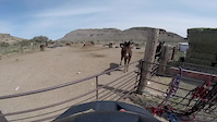
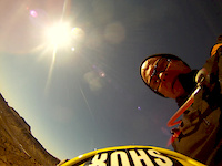
Photos of Red Rock - Cowboy Trails Mountain Bike
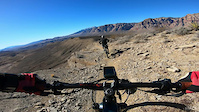
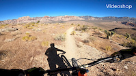
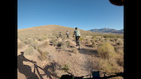
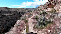
Videos of Red Rock - Cowboy Trails Mountain Bike
trail: EBB'nFlow
6:53 |
46 |
Feb 18, 2025

trail: Flow Job
3:06 |
45 |
Mar 21, 2021
trail: Bone Shaker
4:32 |
289 |
Jul 14, 2020

trail: Flow Job
5:40 |
150 |
Jun 6, 2020
trail: Goat Roper
0:23 |
104 |
May 31, 2020
trail: Flow Job
10:05 |
242 |
Apr 23, 2020
trail: Bone Shaker
5:59 |
267 |
Apr 10, 2017
trail: Ridge
7:15 |
401 |
Feb 28, 2013
Recent Trail Reports
| status | trail | date | condition | info | user |
|---|---|---|---|---|---|
| Bone Shaker | May 25, 2026 @ 4:15pm (America/Los_Angeles) May 25, 2026 | Dry | Jazzbear1986 | ||
| EBB'nFlow | Apr 13, 2026 @ 9:54am (America/Los_Angeles) Apr 13, 2026 | Dry | wadeinbc | ||
| Kibbles-n-Bits | Apr 9, 2026 @ 9:10am (America/Los_Angeles) Apr 9, 2026 | Dry | wadeinbc | ||
| Flow Job | Feb 19, 2026 @ 5:10pm (America/Los_Angeles) Feb 19, 2026 | Ideal | bizango-x | ||
| Bomb Voyage | Jan 10, 2026 @ 2:21pm (America/Los_Angeles) Jan 10, 2026 | Wet | davidsoutside | ||
| Midas | Dec 14, 2025 @ 8:39am (America/Los_Angeles) Dec 14, 2025 | Dry | mathesonmb | ||
| First Finger | Nov 25, 2025 @ 10:08am (America/Los_Angeles) Nov 25, 2025 | Ideal | Joemannn1 | ||
| Fossil Canyon | Nov 25, 2025 @ 10:08am (America/Los_Angeles) Nov 25, 2025 | Ideal | Joemannn1 | ||
| Bob Gnarly | Nov 16, 2025 @ 2:00pm (America/Los_Angeles) Nov 16, 2025 | Ideal | Jazzbear1986 | ||
| Goat Roper | Oct 14, 2025 @ 4:17pm (America/Los_Angeles) Oct 14, 2025 | Dry | mathesonmb |
Activity Feed
| username | action | type | title | date |
|---|---|---|---|---|
| metalheadmilo17 | difficultyvote | trail | activity #97605281 | Jun 22, 2026 @ 10:06pm 4 hours |
| Dthorn0822 | add | video | activity #97415482 | Jun 20, 2026 @ 11:14am 3 days |
| y4NpsS | wishlist | trail | activity #97243530 and 1 more | Jun 18, 2026 @ 4:49am Jun 18, 2026 |
| alphaartis | ridden | route | activity #97040312 | Jun 15, 2026 @ 7:37am Jun 15, 2026 |
| Tmcgraw16 | wishlist | trail | activity #95820814 | May 29, 2026 @ 8:14pm May 29, 2026 |
Recent Comments
| username | type | title | comment | date |
|---|---|---|---|---|
| trail | This should be double bkac | May 9, 2026 @ 10:20pm May 9, 2026 | ||
| trail | Learn how to ride. | May 8, 2026 @ 4:49pm May 8, 2026 | ||
| trail | I guess we’re appreciative of any... | May 6, 2026 @ 11:24pm May 6, 2026 | ||
| trail | Very narrow and tight in places. One medium... | Apr 28, 2026 @ 11:11pm Apr 28, 2026 | ||
| trail | Perfection - best trail in Vegas 🤘 | Apr 17, 2026 @ 5:33pm Apr 17, 2026 |
Nearby Areas
| name | distance | ||||
|---|---|---|---|---|---|
| Calico Basin Area | 7 | 5 | 3 | 3.3 km | |
| Red Rock - Bear’s Best | 13 | 52 | 10 | 4.4 km | |
| Red Rock Canyon National Conservation Area | 1 | 5.1 km | |||
| Southwest Ridge | 4 | 7 | 3 | 2 | 6.7 km |
| Cottonwood Valley | 23 | 23 | 12 | 8 km |
Local Badges
-

Completionist1 awarded
Activity Type Stats
| activitytype | trails | distance | descent | descent distance | total vertical | rating | global rank | state rank | photos | reports | routes | ridelogs |
|---|---|---|---|---|---|---|---|---|---|---|---|---|
| Mountain Bike | 29 | 41 miles | 8,927 ft | 19 miles | 12,703 ft | #1,945 | #654 | 264 | 411 | 10 | 7,259 | |
| E-Bike | 1 | 329 | 561 | |||||||||
| Hike | 33 | 43 miles | 8,937 ft | 19 miles | 12,703 ft | #722 | #376 | 4 | 420 | 1 | 886 | |
| Trail Running | 33 | 43 miles | 8,937 ft | 19 miles | 12,703 ft | #3,022 | #787 | 420 | 2 | 387 |
Frequently Asked Questions About Red Rock - Cowboy Trails
▼
What are the highest rated mountain biking trails in Red Rock - Cowboy Trails?
The highest rated mountain biking trails in Red Rock - Cowboy Trails are:
- Bone Shaker (4.6/5)
- EBB'nFlow (4.4/5)
- Goat Roper (4.3/5)
- Flow Job (4.2/5)
- Bomb Voyage (4.2/5)
▼
What is the best time of the year to ride in Red Rock - Cowboy Trails?
Based on ride log data, the most popular months to ride in Red Rock - Cowboy Trails are:
- December (100 activities)
- November (87 activities)
- April (83 activities)
▼
Where can I park to ride in Red Rock - Cowboy Trails?
There are 4 parking locations listed in Red Rock - Cowboy Trails. The most popular parking spots are: View all parking and trailhead locations on the map to plan your visit.
▼
What is the longest trail in Red Rock - Cowboy Trails?
The longest trail in Red Rock - Cowboy Trails is EBB'nFlow at 7.1 miles. View all trails sorted by distance.
Activities
Trails
- Hard trails in Red Rock - Cowboy Trails
- Easy trails in Red Rock - Cowboy Trails
- Favorite trails in Red Rock - Cowboy Trails
- Most ridden trails in Red Rock - Cowboy Trails
- Singletrack in Red Rock - Cowboy Trails
- Viewpoint trails in Red Rock - Cowboy Trails
- Trails with technical features in Red Rock - Cowboy Trails
- Race routes in Red Rock - Cowboy Trails
Points of Interest
- By brenthillier
 NSMBA TRAILFORKS & contributors
 - Admins: Las Vegas, RedRock, BLM NV GBNM
- #3965 - 23,360 views
- red rock - cowboy trails activity log | embed map of Red Rock - Cowboy Trails mountain bike trails | red rock - cowboy trails mountain biking points of interest polygons
Downloading of trail gps tracks in kml & gpx formats is enabled for Red Rock - Cowboy Trails.
You must login to download files.