close
-
Layers w
- Weather Layers
- Pro
- Pro
- Pro
- Pro
- Pro
- Pro
- More Layers
- Pro
- Pro
- Pro
- Pro
-
Upgrade to

3D
Trail Conditions
- Unknown
- Snow Groomed
- Snow Packed
- Snow Covered
- Snow Cover Partial
- Freeze/thaw Cycle
- Icy
- Prevalent Mud
- Wet
- Variable
- Ideal
- Dry
- Very Dry
Trail Flow (Ridden Direction)
Trailforks scans users ridelogs to determine the most popular direction each trail is ridden. A good flowing trail network will have most trails flowing in a single direction according to their intension.
The colour categories are based on what percentage of riders are riding a trail in its intended direction.
The colour categories are based on what percentage of riders are riding a trail in its intended direction.
- > 96%
- > 90%
- > 80%
- > 70%
- > 50%
- < 50%
- bi-directional trail
- no data
Trail Last Ridden
Trailforks scans ridelogs to determine the last time a trail was ridden.
- < 2 days
- < 1 week
- < 2 weeks
- < 1 month
- < 6 months
- > 6 months
Trail Ridden Direction
The intended direction a trail should be ridden.
- Downhill Only
- Downhill Primary
- Both Directions
- Uphill Primary
- Uphill Only
- One Direction
Contribute Details
Colors indicate trail is missing specified detail.
- Description
- Photos
- Description & Photos
- Videos
Trail Popularity ?
Trailforks scans ridelogs to determine which trails are ridden the most in the last 9 months.
Trails are compared with nearby trails in the same city region with a possible 25 colour shades.
Think of this as a heatmap, more rides = more kinetic energy = warmer colors.
- most popular
- popular
- less popular
- not popular
ATV/ORV/OHV Filter
Max Vehicle Width
inches
US Cell Coverage
Legend

Radar Time
Activity Recordings
Trailforks uses anonymized public activity data.
?
Activity Recordings
Trailforks uses anonymized public activity data.
?
Personal Heatmap
▶
Activity Types
all
/
none
▶
Options
2
Date range
month
–
Winter Trails
Warning
A routing network for winter maps does not exist. Selecting trails using the winter trails layer has been disabled.
Missing Trails
Most Popular
Least Popular
Trails are colored based on popularity. The more popular a trail is, the more red. Less popular trails trend towards green.
Jump Magnitude Heatmap
Heatmap of where riders jump on trails. Zoom in to see individual jumps, click circles to view jump details.
BC Backroad Status
![map legend]()
Service Road Atlas is a free to use, community-driven service for viewing and creating reports on the numerous back-country service roads around B.C. and Alberta.

Slope Aspect
Direction the slope faces
Trails Deemphasized
Trails are shown in grey.
Only show trails with no bike usage.
Suggested Layers
Based on selected activity type
Save the current map location and zoom level as your default home location whenever this page is loaded.
Save
No description for Cranbrook Hill has been added yet!
Login or register to submit one.
Primary Trail Type: All-Mountain & Downhill
Shuttleable: YES
Activities Click to view
- Mountain Bike
15 trails
- E-Bike
9 trails
- Horse
8 trails
- Hike
17 trails
- Trail Running
15 trails
- Dirtbike/Moto
9 trails
Region Details
- 2
- 9
- 2
- 1
- 1
Region Status
Open as of Jul 3, 2025Stats
- Avg Trail Rating
- Trails (view details)
- 19
- Trails Mountain Bike
- 15
- Trails E-Bike
- 9
- Trails Horse
- 8
- Trails Hike
- 17
- Trails Trail Running
- 15
- Trails Dirtbike/Moto
- 9
- Total Distance
- 19 miles
- Total Descent
- 3,268 ft
- Total Vertical
- 645 ft
- Highest Trailhead
- 2,773 ft
- Reports
- 85
- Photos
- 40
- Ridden Counter
- 593
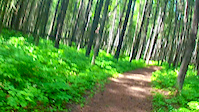
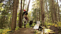
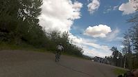
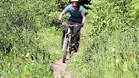
Popular Cranbrook Hill Mountain Biking Trails
• 55 ★ 3.5 • 8 miles • 886 ft • 109 •
The trail has a fairly deep layer of wood chips that are soft so it is a bit of a slow go. There are lots of nice wood sidewalks/bridges across creeks and wet areas. The signage is good. The trail also shows up on Google Maps if in...
• 35 ★ 5.0 • 3,006 ft • 1 ft • 60 •
The staple Cranbrook Run. Varies from Easy ride arounds to big black diamond booters and drops. Very fast flowy sections. The final section of trail in both the video and the Strava segment is actually a trail called R.I.P.
• 45 ★ 4.4 • 1,449 ft • 0 ft • 47 •
Flowy with a couple big hitters. Main feature is a 23ft gap slight step down we named " ". Right next to it is a 13ft b-line gap. There are no ride-arounds on the bottom half with another 20ft gap that eats rims if you come up short...
• 75 ★ 0.0 • 2,178 ft • 30 ft • 10 •
Popular green difficulty singletrack. This mountain bike primary trail can be used both directions. On average it takes 2 minutes to complete this trail.
• 30 ★ 2.0 • 1 mile • 62 ft • 9 •
Trail is part of old system of logging skid roads. For the most part it is quite wide. It connects the Greenway Trail to some other trails that head back toward Kueng Rd, or elsewhere. Mostly grass surface, packed earth in other areas.
• 40 ★ 3.0 • 2,031 ft • 25 ft • 8 •
Moderately popular green difficulty singletrack. This multi-use trail can be used both directions. On average it takes 3 minutes to complete this trail.
• 60 ★ 5.0 • 1,890 ft • 0 ft • 8 •
An alternate connector trail to the Greenway and Sawdust trails. Can be overgrown in the summer, generally well packed by snowmobiles and snowshoes in the winter.
Photos of Cranbrook Hill Mountain Bike
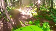
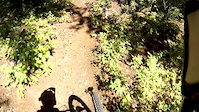
Videos of Cranbrook Hill Mountain Bike
trail: UNBC to Otway
0:16 |
651 |
Jun 18, 2018
trail: Hells Highway
3:30 |
302 |
Jun 16, 2018
trail: Hells Highway
4:04 |
440 |
Jul 28, 2017
trail: Hells Highway
2:38 |
268 |
Aug 15, 2016
trail: Hells Highway
0:45 |
798 |
Nov 24, 2014
trail: Hells Highway
2:28 |
650 |
Jul 7, 2014
trail: Badonkadonk
2:12 |
696 |
Jul 6, 2012
Recent Trail Reports
| status | trail | date | condition | info | user |
|---|---|---|---|---|---|
| UNBC to Otway | Jul 1, 2025 @ 7:41am Jul 1, 2025 | Variable | ajgould | ||
| Into the Sunset | Jun 17, 2025 @ 5:46pm Jun 17, 2025 | Ideal | wade-oh | ||
| Sawdust Connector | Jun 17, 2025 @ 5:46pm Jun 17, 2025 | Ideal | wade-oh | ||
| Dreamcatcher Connector | Jun 17, 2025 @ 5:46pm Jun 17, 2025 | Snow Groomed | wade-oh | ||
| Willmann Access | Feb 17, 2025 @ 11:32am Feb 17, 2025 | Snow Packed | wade-oh | ||
| Winter bypass | Dec 22, 2024 @ 1:54pm Dec 22, 2024 | Snow Groomed | wade-oh | ||
| Droppin' In | Jan 22, 2023 @ 4:23am Jan 22, 2023 | Snow Packed | wade-oh | ||
| Westcrest to greenway access | Oct 20, 2021 @ 11:20am Oct 20, 2021 | Prevalent Mud | Roddy49 | ||
| Sawdust Trail | Aug 10, 2021 @ 9:07am Aug 10, 2021 | Dry | Roddy49 | ||
| Who's Home Connector | Jun 19, 2021 @ 9:14am Jun 19, 2021 | Ideal | Roddy49 |
Activity Feed
| username | action | type | title | date |
|---|---|---|---|---|
| trailforks | add | video | activity #89695062 | Feb 28, 2026 @ 8:00am Feb 28, 2026 |
| OldSlowAdam | ridden | trail | activity #80506354 | Sep 16, 2025 @ 6:20pm Sep 16, 2025 |
| Teueikan | wishlist | trail | activity #75974929 | Jul 15, 2025 @ 12:50pm Jul 15, 2025 |
| wade-oh | add | report | activity #74032875 | Jun 18, 2025 @ 6:04am Jun 18, 2025 |
| RuthBonk | vote | trail | activity #72572048 | May 28, 2025 @ 6:44am May 28, 2025 |
Recent Comments
| username | type | title | comment | date |
|---|---|---|---|---|
| trail | Rode today (June 17 2021). Several muddy... | Jun 17, 2021 @ 6:28pm Jun 17, 2021 | ||
| trail | May 25 2019 - Trail is in good condition, some... | May 28, 2019 @ 6:53pm May 28, 2019 |
Nearby Areas
| name | distance | ||||
|---|---|---|---|---|---|
| University Hill | 8 | 12 | 7 | 1.4 km | |
| Greenway/Forests for the World | 38 | 40 | 7 | 1.8 km | |
| The Swedes | 3.1 km | ||||
| Pidherny Recreation Site | 19 | 45 | 19 | 1 | 4.9 km |
| Otway | 7 | 19 | 13 | 5.1 km |
Local Mountain Biking Directory
-
Caledonia Nordic Ski Club
![Caledonia Nordic Ski Club]()
-
Association of Caledonia Trailbuilders
![Association of Caledonia Trailbuilders]()
-
Prince George Cycling ClubTrail Association
![Prince George Cycling Club]()
-
Ruckus Skis Boards And BikesBike Shop
![Ruckus Skis Boards And Bikes]()
-
Players Bench Sports & Evolve BikeBike Shop
-
Koops Bike ShopBike Shop
Activity Type Stats
| activitytype | trails | distance | descent | descent distance | total vertical | rating | global rank | state rank | photos | reports | routes | ridelogs |
|---|---|---|---|---|---|---|---|---|---|---|---|---|
| Mountain Bike | 15 | 16 miles | 2,858 ft | 8 miles | 617 ft | #7,894 | #321 | 40 | 82 | 2,818 | ||
| E-Bike | 9 | 12 miles | 1,883 ft | 6 miles | 587 ft | #6,443 | #244 | 82 | 55 | |||
| Horse | 8 | 4 miles | 410 ft | 2 miles | 174 ft | #1,992 | #61 | 5 | 1 | |||
| Hike | 17 | 19 miles | 3,238 ft | 10 miles | 646 ft | #8,701 | #336 | 82 | 154 | |||
| Trail Running | 15 | 16 miles | 2,858 ft | 8 miles | 617 ft | #8,606 | #318 | 82 | 865 | |||
| Dirtbike/Moto | 9 | 4 miles | 440 ft | 2 miles | 351 ft | #821 | #70 | 5 | 3 |
Frequently Asked Questions About Cranbrook Hill
▼
What are the highest rated mountain biking trails in Cranbrook Hill?
The highest rated mountain biking trails in Cranbrook Hill are:
- Hells Highway (4.3/5)
- Into the Sunset (4.1/5)
- Badonkadonk (4.1/5)
- UNBC to Otway (3.9/5)
- Fresca Friday (3.8/5)
▼
What is the best time of the year to ride in Cranbrook Hill?
Based on ride log data, the most popular months to ride in Cranbrook Hill are:
- July (24 activities)
- August (19 activities)
- June (17 activities)
▼
Where can I park to ride in Cranbrook Hill?
Check the Cranbrook Hill trail map for trailhead and parking information. Community members regularly update access and parking details for trails in the area.
▼
What is the longest trail in Cranbrook Hill?
The longest trail in Cranbrook Hill is UNBC to Otway at 7.8 miles. View all trails sorted by distance.
Activities
- By brenthillier
 NSMBA TRAILFORKS & contributors
 - Admins: PGCC, forestuser, free-riders, Mostlyharmless80, NBC, PGBRS, aleksa
- #3404 - 9,642 views
- cranbrook hill activity log | embed map of Cranbrook Hill mountain bike trails |
Downloading of trail gps tracks in kml & gpx formats is enabled for Cranbrook Hill.
You must login to download files.