close
-
Layers w
- Weather Layers
- Pro
- Pro
- Pro
- Pro
- Pro
- Pro
- More Layers
- Pro
- Pro
- Pro
- Pro
-
Upgrade to

3D
Trail Conditions
- Unknown
- Snow Groomed
- Snow Packed
- Snow Covered
- Snow Cover Partial
- Freeze/thaw Cycle
- Icy
- Prevalent Mud
- Wet
- Variable
- Ideal
- Dry
- Very Dry
Trail Flow (Ridden Direction)
Trailforks scans users ridelogs to determine the most popular direction each trail is ridden. A good flowing trail network will have most trails flowing in a single direction according to their intension.
The colour categories are based on what percentage of riders are riding a trail in its intended direction.
The colour categories are based on what percentage of riders are riding a trail in its intended direction.
- > 96%
- > 90%
- > 80%
- > 70%
- > 50%
- < 50%
- bi-directional trail
- no data
Trail Last Ridden
Trailforks scans ridelogs to determine the last time a trail was ridden.
- < 2 days
- < 1 week
- < 2 weeks
- < 1 month
- < 6 months
- > 6 months
Trail Ridden Direction
The intended direction a trail should be ridden.
- Downhill Only
- Downhill Primary
- Both Directions
- Uphill Primary
- Uphill Only
- One Direction
Contribute Details
Colors indicate trail is missing specified detail.
- Description
- Photos
- Description & Photos
- Videos
Trail Popularity ?
Trailforks scans ridelogs to determine which trails are ridden the most in the last 9 months.
Trails are compared with nearby trails in the same city region with a possible 25 colour shades.
Think of this as a heatmap, more rides = more kinetic energy = warmer colors.
- most popular
- popular
- less popular
- not popular
ATV/ORV/OHV Filter
Max Vehicle Width
inches
US Cell Coverage
Legend

Radar Time
Activity Recordings
Trailforks uses anonymized public activity data.
?
Activity Recordings
Trailforks uses anonymized public activity data.
?
Personal Heatmap
▶
Activity Types
all
/
none
▶
Options
2
Date range
month
–
Winter Trails
Warning
A routing network for winter maps does not exist. Selecting trails using the winter trails layer has been disabled.
Missing Trails
Most Popular
Least Popular
Trails are colored based on popularity. The more popular a trail is, the more red. Less popular trails trend towards green.
Jump Magnitude Heatmap
Heatmap of where riders jump on trails. Zoom in to see individual jumps, click circles to view jump details.
BC Backroad Status
![map legend]()
Service Road Atlas is a free to use, community-driven service for viewing and creating reports on the numerous back-country service roads around B.C. and Alberta.

Slope Aspect
Direction the slope faces
Trails Deemphasized
Trails are shown in grey.
Only show trails with no bike usage.
Suggested Layers
Based on selected activity type
Save the current map location and zoom level as your default home location whenever this page is loaded.
Save
No description for Crescent City has been added yet!
Login or register to submit one.
Activities Click to view
- Mountain Bike
22 trails
- E-Bike
5 trails
- Adaptive Bike
0 trails
- Horse
15 trails
- Hike
58 trails
- Trail Running
57 trails
Region Details
- 6
- 12
- 4
Region Status
Open as of Oct 20, 2025Local Trail Association
Stats
- Avg Trail Rating
- Trails (view details)
- 58
- Trails Mountain Bike
- 22
- Trails E-Bike
- 5
- Trails Horse
- 15
- Trails Hike
- 58
- Trails Trail Running
- 57
- Total Distance
- 91 miles
- Total Descent Distance
- 36 miles
- Total Descent
- 11,343 ft
- Total Vertical
- 4,278 ft
- Highest Trailhead
- 4,284 ft
- Reports
- 182
- Photos
- 115
- Ridden Counter
- 1,940
Articles

The 12 Best Campgrounds in California to Ditch the Crowds
Apr 8, 2025 from ool-test.outsideonline.com
The Golden State might have more campgrounds than any other in the U.S.—and more visitors, too. From desert to coast to mountains, here are the...
The 12 Best Campgrounds in California to Ditch the Crowds
Apr 8, 2025 from outsideonline.com
The Golden State might have more campgrounds than any other in the U.S.—and more visitors, too. From desert to coast to mountains, here are the...
Sub Regions
-
Del Norte Coast Redwoods State Park
- 1
- 1
-
Jedediah Smith Redwoods State Park
- 1
-
Redwood National and State Parks
- 2
- 2
-
Siskiyou Wilderness
-
Tolowa Dunes State Park
- 8
Popular Crescent City Mountain Biking Trails
• 95 ★ 3.8 • 9 miles • 1,958 ft • 116 •
Popular blue difficulty singletrack. This multi-use trail can be used both directions. On average it takes 1 hour31 minutes to complete this trail.
• 100 ★ 3.0 • 7 miles • 1,534 ft • 95 •
This is a beautiful trail through the redwoods with an occasional view of the ocean.
• 95 ★ 0.0 • 1,099 ft • 0 ft • 34 •
Popular blue difficulty singletrack. This mountain bike primary trail can be used both directions. On average it takes 1 minutes to complete this trail.
• 90 ★ 0.0 • 302 ft • 0 ft • 13 • • hike
Popular green difficulty doubletrack. This hike primary trail can be used both directions. On average it takes minutes to complete this trail.
• 85 ★ 0.0 • 2,733 ft • 0 ft • 4 •
Popular green difficulty singletrack. This multi-use trail can be used both directions. On average it takes 2 minutes to complete this trail.
• 5 ★ 0.0 • 528 ft • 0 ft • 2 • • hike
Less popular green difficulty singletrack. This hike primary trail can be used both directions. On average it takes minutes to complete this trail.
• 5 ★ 0.0 • 4 miles • 185 ft • 2 • • hike
Less popular green difficulty singletrack. This hike primary trail can be used both directions. On average it takes 42 minutes to complete this trail.
Crescent City Mountain Bike Routes
7 miles • 928 ft • 1 •
13 miles • 2,186 ft • 0 •
4,928 ft • 380 ft • 2 •
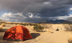
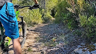
Photos of Crescent City Mountain Bike
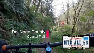
Videos of Crescent City Mountain Bike
trail: Little Bald Hills
0:18 |
600 |
Sep 12, 2019
24:55 |
1725 |
Apr 15, 2021 , Crescent City
Recent Trail Reports
| status | trail | date | condition | info | user |
|---|---|---|---|---|---|
| Little Bald Hills | Oct 19, 2025 @ 8:29am (America/Los_Angeles) Oct 19, 2025 | Variable | NeariahGil | ||
| Coastal Trail - Last Chance Section | Sep 18, 2025 @ 1:08pm (America/Los_Angeles) Sep 18, 2025 | Dry | falcon013 | ||
| Nickel Creek Trail | May 27, 2024 @ 4:20pm May 27, 2024 | Ideal | Crash88 | ||
| Trail | Dec 5, 2022 @ 2:33pm Dec 5, 2022 | Variable | ChipqFPPis | ||
| Parking Lot Connector | Jul 1, 2022 @ 7:25pm Jul 1, 2022 | Prevalent Mud | Njamison |
Activity Feed
| username | action | type | title | date |
|---|---|---|---|---|
| ReesgoIa1w | wishlist | trail | activity #93126826 | Apr 21, 2026 @ 8:19pm Apr 21, 2026 |
| larryssman7 | add | photo | activity #92263704 and 1 more | Apr 9, 2026 @ 10:31am Apr 9, 2026 |
| ListeriX | wishlist | trail | activity #92230188 | Apr 8, 2026 @ 7:23pm Apr 8, 2026 |
| ListeriX | wishlist | trail | activity #92191421 | Apr 8, 2026 @ 9:43am Apr 8, 2026 |
| peteygroovy | wishlist | trail | activity #91175625 | Mar 23, 2026 @ 5:24pm Mar 23, 2026 |
Recent Comments
| username | type | title | comment | date |
|---|---|---|---|---|
| trail | Looking forward to ride | Aug 13, 2025 @ 9:14pm Aug 13, 2025 | ||
| trail | Rode it N to S. Brutal climb from Enders... | Jun 17, 2025 @ 4:10pm Jun 17, 2025 | ||
| trail | Not sure MTB is allowed on this trail. I took... | Jun 17, 2025 @ 4:05pm Jun 17, 2025 | ||
| trail | Fantastic must bike trail! Rode from south to... | Jun 2, 2025 @ 9:44pm Jun 2, 2025 | ||
| trail | Good climb from North parking lot riding south... | Aug 7, 2024 @ 8:52am Aug 7, 2024 |
Local Badges
-

Epic Mountain Bike Climb 2k8 awarded -

Climbing 10k Badge1 awarded -

Mountain Biking 100k Badge0 awarded -

Epic Ride Descent 2k8 awarded -

Descent 10k Badge1 awarded -

Descent 100k Badge0 awarded
Bike & Skill Parks
| name | type | city | rating |
|---|---|---|---|
| Crescent City Asphalt Pumptrack | skill park | Crescent City |
Activity Type Stats
| activitytype | trails | distance | descent | descent distance | total vertical | rating | global rank | state rank | photos | reports | routes | ridelogs |
|---|---|---|---|---|---|---|---|---|---|---|---|---|
| Mountain Bike | 22 | 56 miles | 6,407 ft | 22 miles | 2,080 ft | #7,016 | #2,343 | 104 | 178 | 3 | 1,122 | |
| E-Bike | 5 | 20 miles | 2,822 ft | 9 miles | 1,942 ft | #5,407 | #1,681 | 8 | 146 | 46 | ||
| Horse | 15 | 33 miles | 3,917 ft | 14 miles | 2,077 ft | #1,523 | #896 | 77 | ||||
| Hike | 58 | 91 miles | 11,342 ft | 36 miles | 4,278 ft | #2,255 | #912 | 3 | 176 | 8 | 1,380 | |
| Trail Running | 57 | 91 miles | 11,342 ft | 36 miles | 2,080 ft | #2,822 | #811 | 176 | 6 | 157 |
Frequently Asked Questions About Crescent City
▼
What are the best places to ride in Crescent City?
Crescent City has 5 areas to explore for mountain biking. The top rated areas are:
▼
What are the highest rated mountain biking trails in Crescent City?
The highest rated mountain biking trails in Crescent City are:
- Little Bald Hills (3.9/5)
- Coastal Trail - Last Chance Section (3.5/5)
- Nickel Creek Trail (0/5)
- California Coastal Cycleway (0/5)
- Parking Lot Connector (0/5)
▼
What is the best time of the year to ride in Crescent City?
Based on ride log data, the most popular months to ride in Crescent City are:
- May (21 activities)
- August (18 activities)
- July (14 activities)
▼
Where can I park to ride in Crescent City?
Activities
Trails
- By ericfoltz
 TRAILFORKS & contributors
 - Admins: sanfret
- #12419 - 10,343 views
- crescent city activity log | embed map of Crescent City mountain bike trails | crescent city mountain biking points of interest
Downloading of trail gps tracks in kml & gpx formats is enabled for Crescent City.
You must login to download files.