close
-
Layers w
- Weather Layers
- Pro
- Pro
- Pro
- Pro
- Pro
- Pro
- More Layers
- Pro
- Pro
- Pro
- Pro
-
Upgrade to

3D
Trail Conditions
- Unknown
- Snow Groomed
- Snow Packed
- Snow Covered
- Snow Cover Partial
- Freeze/thaw Cycle
- Icy
- Prevalent Mud
- Wet
- Variable
- Ideal
- Dry
- Very Dry
Trail Flow (Ridden Direction)
Trailforks scans users ridelogs to determine the most popular direction each trail is ridden. A good flowing trail network will have most trails flowing in a single direction according to their intension.
The colour categories are based on what percentage of riders are riding a trail in its intended direction.
The colour categories are based on what percentage of riders are riding a trail in its intended direction.
- > 96%
- > 90%
- > 80%
- > 70%
- > 50%
- < 50%
- bi-directional trail
- no data
Trail Last Ridden
Trailforks scans ridelogs to determine the last time a trail was ridden.
- < 2 days
- < 1 week
- < 2 weeks
- < 1 month
- < 6 months
- > 6 months
Trail Ridden Direction
The intended direction a trail should be ridden.
- Downhill Only
- Downhill Primary
- Both Directions
- Uphill Primary
- Uphill Only
- One Direction
Contribute Details
Colors indicate trail is missing specified detail.
- Description
- Photos
- Description & Photos
- Videos
Trail Popularity ?
Trailforks scans ridelogs to determine which trails are ridden the most in the last 9 months.
Trails are compared with nearby trails in the same city region with a possible 25 colour shades.
Think of this as a heatmap, more rides = more kinetic energy = warmer colors.
- most popular
- popular
- less popular
- not popular
ATV/ORV/OHV Filter
Max Vehicle Width
inches
US Cell Coverage
Legend

Radar Time
Activity Recordings
Trailforks uses anonymized public activity data.
?
Activity Recordings
Trailforks uses anonymized public activity data.
?
Personal Heatmap
▶
Activity Types
all
/
none
▶
Options
2
Date range
month
–
Winter Trails
Warning
A routing network for winter maps does not exist. Selecting trails using the winter trails layer has been disabled.
Missing Trails
Most Popular
Least Popular
Trails are colored based on popularity. The more popular a trail is, the more red. Less popular trails trend towards green.
Jump Magnitude Heatmap
Heatmap of where riders jump on trails. Zoom in to see individual jumps, click circles to view jump details.
BC Backroad Status
![map legend]()
Service Road Atlas is a free to use, community-driven service for viewing and creating reports on the numerous back-country service roads around B.C. and Alberta.

Slope Aspect
Direction the slope faces
Trails Deemphasized
Trails are shown in grey.
Only show trails with no bike usage.
Suggested Layers
Based on selected activity type
Save the current map location and zoom level as your default home location whenever this page is loaded.
SaveThis region is Unsanctioned, Ride at your own Risk!
Creswick State Forest includes all of the tracks that aren’t sanctioned, and not part of Djuwang Burring
Primary Trail Type: Cross-Country
Land Status: State Forest
 google parking directions
 Activities Click to view
- Mountain Bike
44 trails
- E-Bike
30 trails
- Hike
17 trails
- Trail Running
18 trails
Region Details
- 2
- 2
- 30
- 3
Region Status
Caution as of May 16, 2026Stats
- Avg Trail Rating
- Trails (view details)
- 37
- Trails Mountain Bike
- 45
- Trails E-Bike
- 30
- Trails Hike
- 17
- Trails Trail Running
- 18
- Total Distance
- 28 miles
- Total Descent
- 2,722 ft
- Total Vertical
- 552 ft
- Highest Trailhead
- 2,030 ft
- Reports
- 155
- Photos
- 12
- Ridden Counter
- 1,620
Popular Creswick State Forest Mountain Biking Trails
• 65 ★ 4.0 • 584 ft • 11 ft • 323 •
Moderately popular blue difficulty singletrack. This mountain bike primary trail can be used both directions.
• 60 ★ 0.0 • 972 ft • 77 ft • 183 •
Moderately popular green difficulty singletrack. This mountain bike primary trail can be used both directions. On average it takes 2 minutes to complete this trail.
• 50 ★ 3.7 • 4,498 ft • 48 ft • 98 •
Moderately popular blue difficulty singletrack. This mountain bike primary trail can be used both directions and has a easy overall physical rating. On average it takes 7 minutes to complete this trail.
• 40 ★ 0.0 • 2,879 ft • 41 ft • 88 •
Cool trail along an old gold mining water race. Apart of the Goldfields Track
• 50 ★ 4.0 • 1,711 ft • 55 ft • 83 •
Moderately popular blue difficulty singletrack. This mountain bike primary trail can be used both directions. On average it takes 3 minutes to complete this trail.
• 40 ★ 5.0 • 5,107 ft • 86 ft • 79 •
Moderately popular blue difficulty singletrack. This mountain bike primary trail can be used downhill primary. On average it takes 8 minutes to complete this trail.
Creswick State Forest Mountain Bike Routes
15 miles • 1,210 ft • 6 •
Swagmen used to talk about “taking to the wallaby track” and swamp wallabies are common in the...
12 miles • 1,385 ft • 14 • Loop •
A loop taking in the majority of the trails in the area. can easily be left out if it is too technical for...
★ 5.0 • 16 miles • 2,006 ft • 9 • Loop • Race •
The course for Round 1 of the Shifty 50. The course takes in the best single track of the creswick state...
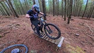
Photos of Creswick State Forest Mountain Bike
Videos of Creswick State Forest Mountain Bike
trail: Slightly Miffed Dunnart
18:20 |
3 |
Jun 11, 2026 , Creswick
Recent Trail Reports
| status | trail | date | condition | info | user |
|---|---|---|---|---|---|
| Slightly Miffed Dunnart | May 17, 2026 @ 4:30pm (Australia/Melbourne) May 16, 2026 | Wet | SuperFrodo | ||
| Gold Digger | May 10, 2026 @ 4:53pm (Australia/Melbourne) May 9, 2026 | Unknown | kj76 | ||
| Jackass to Cosgroves | Apr 5, 2026 @ 9:46pm (Australia/Melbourne) Apr 5, 2026 | Variable | Terby | ||
| Sad Bull | Apr 5, 2026 @ 9:46pm (Australia/Melbourne) Apr 5, 2026 | Variable | Terby | ||
| King Arthurs Weedy Beast | Apr 5, 2026 @ 9:46pm (Australia/Melbourne) Apr 5, 2026 | Variable | Terby | ||
| Smiley Bull | Apr 5, 2026 @ 9:46pm (Australia/Melbourne) Apr 5, 2026 | Variable | Terby | ||
| Flume Trail | Apr 5, 2026 @ 9:46pm (Australia/Melbourne) Apr 5, 2026 | Variable | Terby | ||
| Wombat Link | Jan 21, 2026 @ 10:32am (Australia/Melbourne) Jan 20, 2026 | Dry | bigbibmtb | ||
| Wiggo | Nov 16, 2024 @ 9:31am Nov 16, 2024 | Dry | Squizza75 | ||
| Bear Grylls | Nov 16, 2024 @ 9:31am Nov 16, 2024 | Dry | Squizza75 |
Activity Feed
| username | action | type | title | date |
|---|---|---|---|---|
| SuperFrodo | vote | trail | activity #96725578 | Jun 11, 2026 @ 2:57am Jun 11, 2026 |
| SuperFrodo | add | video | activity #96725512 | Jun 11, 2026 @ 2:55am Jun 11, 2026 |
| SuperFrodo | comment | trail | activity #95066284 | May 19, 2026 @ 2:38pm May 19, 2026 |
| SuperFrodo | add | report | activity #94895325 | May 17, 2026 @ 6:18am May 17, 2026 |
| kj76 | add | report | activity #94401555 | May 9, 2026 @ 11:53pm May 9, 2026 |
Recent Comments
| username | type | title | comment | date |
|---|---|---|---|---|
| trail | Cool old technical trail with some woodwork... | May 19, 2026 @ 2:38pm May 19, 2026 | ||
| report | tree over the track and a few really muddy... | Sep 16, 2021 @ 6:46pm Sep 16, 2021 | ||
| trail | Very disappointed and downright angry that... | Nov 6, 2020 @ 8:35pm Nov 6, 2020 | ||
| report | Good ridding Over The Top still needs work on... | Mar 6, 2016 @ 6:17pm Mar 6, 2016 |
Nearby Areas
| name | distance | ||||
|---|---|---|---|---|---|
| RACV Goldfields Resort | 3 | 6 | 1.5 km | ||
| Djuwang Baring | 16 | 21 | 8 | 1 | 2.5 km |
| Nerrina Trails | 1 | 2 | 6 | 4.8 km | |
| Black Hill Bike Park | 3 | 2 | 2 | 3 | 6.3 km |
| Woowookarung Regional Park | 5 | 11 | 9.2 km |
Local Badges
-

Completionist0 awarded
Activity Type Stats
| activitytype | trails | distance | descent | descent distance | total vertical | rating | global rank | state rank | photos | reports | routes | ridelogs |
|---|---|---|---|---|---|---|---|---|---|---|---|---|
| Mountain Bike | 44 | 28 miles | 2,723 ft | 11 miles | 551 ft | #3,800 | #185 | 12 | 157 | 4 | 978 | |
| E-Bike | 30 | 19 miles | 1,522 ft | 6 miles | 469 ft | #4,746 | #247 | 126 | 164 | |||
| Hike | 17 | 9 miles | 1,004 ft | 4 miles | 551 ft | #11,631 | #429 | 110 | 13 | |||
| Trail Running | 18 | 9 miles | 1,004 ft | 4 miles | 551 ft | #10,519 | #389 | 115 | 31 |
Frequently Asked Questions About Creswick State Forest
▼
What are the highest rated mountain biking trails in Creswick State Forest?
The highest rated mountain biking trails in Creswick State Forest are:
- BrackenBerm (4.2/5)
- Shuttleworth Singletrack (4.1/5)
- To the Campgrounds - GT (4.1/5)
- Bear Grylls (4.1/5)
- Cliffy's (4.1/5)
▼
What is the best time of the year to ride in Creswick State Forest?
Based on ride log data, the most popular months to ride in Creswick State Forest are:
- February (14 activities)
- March (10 activities)
- April (5 activities)
▼
Where can I park to ride in Creswick State Forest?
There are 4 parking locations listed in Creswick State Forest. The most popular parking spots are: View all parking and trailhead locations on the map to plan your visit.
▼
What is the longest trail in Creswick State Forest?
The longest trail in Creswick State Forest is For Fallen Legends at 2.7 km. View all trails sorted by distance.
Activities
Trails
- Hard trails in Creswick State Forest
- Easy trails in Creswick State Forest
- Favorite trails in Creswick State Forest
- Most ridden trails in Creswick State Forest
- Singletrack in Creswick State Forest
- Viewpoint trails in Creswick State Forest
- Trails with technical features in Creswick State Forest
- Race routes in Creswick State Forest
Points of Interest
- By dom25
 & contributors
 - Admins: apply
- #23820 - 4,889 views
- creswick state forest activity log | embed map of Creswick State Forest mountain bike trails | creswick state forest mountain biking points of interest
Downloading of trail gps tracks in kml & gpx formats is enabled for Creswick State Forest.
You must login to download files.