close
-
Layers w
- Weather Layers
- Pro
- Pro
- Pro
- Pro
- Pro
- Pro
- More Layers
- Pro
- Pro
- Pro
- Pro
-
Upgrade to

3D
Trail Conditions
- Unknown
- Snow Groomed
- Snow Packed
- Snow Covered
- Snow Cover Partial
- Freeze/thaw Cycle
- Icy
- Prevalent Mud
- Wet
- Variable
- Ideal
- Dry
- Very Dry
Trail Flow (Ridden Direction)
Trailforks scans users ridelogs to determine the most popular direction each trail is ridden. A good flowing trail network will have most trails flowing in a single direction according to their intension.
The colour categories are based on what percentage of riders are riding a trail in its intended direction.
The colour categories are based on what percentage of riders are riding a trail in its intended direction.
- > 96%
- > 90%
- > 80%
- > 70%
- > 50%
- < 50%
- bi-directional trail
- no data
Trail Last Ridden
Trailforks scans ridelogs to determine the last time a trail was ridden.
- < 2 days
- < 1 week
- < 2 weeks
- < 1 month
- < 6 months
- > 6 months
Trail Ridden Direction
The intended direction a trail should be ridden.
- Downhill Only
- Downhill Primary
- Both Directions
- Uphill Primary
- Uphill Only
- One Direction
Contribute Details
Colors indicate trail is missing specified detail.
- Description
- Photos
- Description & Photos
- Videos
Trail Popularity ?
Trailforks scans ridelogs to determine which trails are ridden the most in the last 9 months.
Trails are compared with nearby trails in the same city region with a possible 25 colour shades.
Think of this as a heatmap, more rides = more kinetic energy = warmer colors.
- most popular
- popular
- less popular
- not popular
ATV/ORV/OHV Filter
Max Vehicle Width
inches
US Cell Coverage
Legend

Radar Time
Activity Recordings
Trailforks uses anonymized public activity data.
?
Activity Recordings
Trailforks uses anonymized public activity data.
?
Personal Heatmap
▶
Activity Types
all
/
none
▶
Options
2
Date range
month
–
Winter Trails
Warning
A routing network for winter maps does not exist. Selecting trails using the winter trails layer has been disabled.
Missing Trails
Most Popular
Least Popular
Trails are colored based on popularity. The more popular a trail is, the more red. Less popular trails trend towards green.
Jump Magnitude Heatmap
Heatmap of where riders jump on trails. Zoom in to see individual jumps, click circles to view jump details.
BC Backroad Status
![map legend]()
Service Road Atlas is a free to use, community-driven service for viewing and creating reports on the numerous back-country service roads around B.C. and Alberta.

Slope Aspect
Direction the slope faces
Trails Deemphasized
Trails are shown in grey.
Only show trails with no bike usage.
Suggested Layers
Based on selected activity type
Save the current map location and zoom level as your default home location whenever this page is loaded.
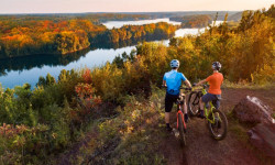
SaveCrow Wing County is a county located in the U.S. state of Minnesota. As of the 2010 census, the population was 62,500. Its county seat is Brainerd. The county was formed in 1857 and organized in 1870.
Crow Wing County is included in the Brainerd, MN Micropolitan Statistical Area.
Crow Wing County is included in the Brainerd, MN Micropolitan Statistical Area.
source: Crow Wing Minnesota
Activities Click to view
- Mountain Bike
153 trails
- E-Bike
113 trails
- Horse
13 trails
- Hike
180 trails
- Trail Running
179 trails
- Dirtbike/Moto
11 trails
- Observed Trials
0 trails
- ATV/ORV/OHV
11 trails
- Snowmobile
9 trails
- Snowshoe
78 trails
- Downhill Ski
0 trails
- Backcountry Ski
0 trails
- Nordic Ski
45 trails
Region Details
- 35
- 15
- 39
- 35
- 20
- 8
Stats
- Avg Trail Rating
- Trails (view details)
- 225
- Trails Mountain Bike
- 153
- Trails E-Bike
- 113
- Trails Gravel Bike
- 38
- Trails Winter Fat Bike
- 1
- Trails Horse
- 13
- Trails Hike
- 180
- Trails Trail Running
- 179
- Trails Dirtbike/Moto
- 11
- Trails ATV/ORV/OHV
- 11
- Trails Snowmobile
- 9
- Trails Snowshoe
- 78
- Trails Nordic Ski
- 45
- Total Distance
- 271 miles
- Total Descent
- 12,794 ft
- Total Vertical
- 321 ft
- Highest Trailhead
- 1,468 ft
- Reports
- 9,721
- Photos
- 1,172
- Ridden Counter
- 104,061
Articles
The Best Mountain Biking in Minnesota
Aug 22, 2024 from outsideonline.com
World-class riding is the state’s best-kept secret. These are the top trails, according to a local expert.
Popular Trail Networks
view all areas »Sub Regions
- Baxter (0)
- Brainerd (3)
- Crosby-Ironton (113)
- Cuyuna (2)
- Deerwood Township (11)
- Gail Lake Township (1)
- Irondale Township (8)
- Nisswa (1)
- Blueberry Bog Non-Motorized Area (1)
- French Rapids (9)
- Larson Lake Forest Recreation Area (11)
- Poor Farm Wildlife Management Area (2)
- Wolf Lake (6)
Popular Crow Wing County Mountain Biking Trails
• 100 ★ 4.9 • 3,589 ft • 61 ft • 2,663 •
Trail Type: Singletrack (XC/AM) Trail Experience: A flowing easy rated trail. Some smaller climbs and descents to learn get used to and a few side hits for those who are are wanting to spice up a beginner rated trail. As this trail...
• 90 ★ 3.8 • 1 mile • 85 ft • 2,516 •
Trail Type: Singletrack (XC/AM) Trail Experience: Starts out with gentle, with smooth small climbs and descents before getting rockier about halfway through. Easily the most chucky section of the Galloping Goose loop, the section along...
• 95 ★ 4.6 • 669 ft • 13 ft • 2,317 •
Popular blue difficulty singletrack. This mountain bike primary trail and has a hard overall physical rating with a 13 ft green climb. On average it takes minutes to complete this trail.
• 95 ★ 4.4 • 1 mile • 17 ft • 2,302 •
Highly rated popular green difficulty singletrack. This mountain bike primary trail and has a moderate overall physical rating with a 17 ft green climb. On average it takes 8 minutes to complete this trail.
• 95 ★ 4.6 • 1 mile • 92 ft • 2,282 •
Highly rated popular green difficulty singletrack. This mountain bike primary trail and has a moderate overall physical rating with a 92 ft green climb. It features berm. On average it takes 8 minutes to complete this trail.
• 100 ★ 4.7 • 5,259 ft • 108 ft • 2,275 •
Easily one of the most fun and popular trails in Cuyuna! The east trails around Yawkey Mine are basically a bike park. All of them are less than 2kms long and everything funnels back to your vehicle. has the standard leg burning "pay...
• 90 ★ 4.4 • 3 miles • 243 ft • 2,218 •
Trail Type: Singletrack (XC/AM) Trail Experience: A flowing easy rated trail with more chunkiness than its southern counterpart (Galloping Goose South). No real climbs and and a barn burner of a descent makes for a less taxing ride than...
Crow Wing County Mountain Bike Routes
★ 5.0 • 102 miles • 5,825 ft • 97 • Loop •
100+ mile MTB trail loop that could be sagged from Yawkey Trail Head
6 miles • 282 ft • 4 • Loop •
This nearly 6 mile mountain biking loop takes you throughout the entire “Outer Rim” tour of the...
★ 2.0 • 16 miles • 721 ft • 11 • Loop •
This 13+ mile mountain biking loop takes you throughout the entire Cuyuna singletrack system in search of...
6 miles • 283 ft • 4 •
This nearly 6 mile mountain biking loop takes you throughout the entire “Outer Rim” tour of the...
28 miles • 2,126 ft • 30 • Loop •
This is my favorite route to get out and enjoy what Cuyuna has to offer. Sometimes I'll bring some coffee...
2 miles • 42 ft • 2 • Loop •
This 1.7 mile loop builds upon the 0.1 mile mountain biking loop within the Miner’s Mountain Rally...
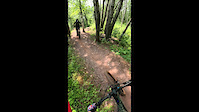
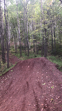
Photos of Crow Wing County Mountain Bike
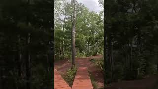
Videos of Crow Wing County Mountain Bike
trail: Sinter
0:14 |
83 |
Nov 18, 2023
0:51 |
206 |
Jun 14, 2019
0:28 |
103 |
Mar 29, 2025 , Crosby-Ironton
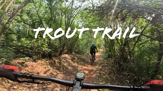
trail: Trout
4:57 |
103 |
Mar 29, 2025 , Crosby-Ironton
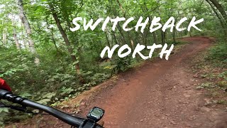
trail: Switchback - North
6:39 |
119 |
Mar 29, 2025 , Crosby-Ironton
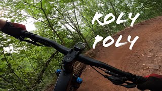
trail: Roly Poly
5:33 |
125 |
Oct 12, 2024 , Crosby-Ironton
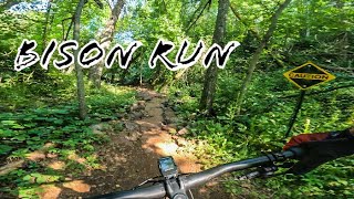
trail: Bison Run
38:34 |
185 |
Oct 12, 2024 , Crosby-Ironton
trail: Bison Run
0:43 |
118 |
Oct 12, 2024 , Crosby-Ironton
Recent Trail Reports
Activity Feed
| username | action | type | title | date |
|---|---|---|---|---|
| LukeVksVIb | wishlist | trail | activity #97143476 | Jun 16, 2026 @ 4:01pm 23 hours |
| EYawkYetiDude | add | report | activity #97129937 | Jun 16, 2026 @ 12:12pm 1 day |
| Bbaction | wishlist | trail | activity #96957890 | Jun 14, 2026 @ 5:26am Jun 14, 2026 |
| EYawkYetiDude | add | report | activity #96933700 and 10 more | Jun 13, 2026 @ 7:11pm Jun 13, 2026 |
| Grantga | vote | trail | activity #96814191 | Jun 12, 2026 @ 10:39am Jun 12, 2026 |
Recent Comments
| username | type | title | comment | date |
|---|---|---|---|---|
| trail | Lappable by WALKING your bike next to Haul... | May 20, 2026 @ 5:27pm May 20, 2026 | ||
| trail | Recently got reworked, making the climb a half... | May 20, 2026 @ 5:22pm May 20, 2026 | ||
| report | I apologize, your work is much appreciated and... | May 3, 2026 @ 3:54pm May 3, 2026 | ||
| trail | Good trail, I wish that trail bit back was a 2... | May 2, 2026 @ 11:18am May 2, 2026 | ||
| report | if debris is off the paved trail it's open | Apr 14, 2026 @ 2:46pm Apr 14, 2026 |
Local Badges
-

Mahnomen Superstar127 awarded -

Lil Peeps572 awarded -

Have Great Skills143 awarded -

Hog Roast156 awarded -

Yawkey Superstar449 awarded -

Portsmouth Superstar481 awarded
Bike & Skill Parks
| name | type | city | rating |
|---|---|---|---|
| City of Cuyuna Pump Track | skill park | ||
| Trax North MX | skill park | Cuyuna | |
| Overdrive Skills Area | skill park | Crosby-Ironton |
Upcoming Local Events
Activity Type Stats
| activitytype | trails | distance | descent | descent distance | total vertical | rating | global rank | state rank | photos | reports | routes | ridelogs |
|---|---|---|---|---|---|---|---|---|---|---|---|---|
| Mountain Bike | 153 | 217 miles | 11,299 ft | 72 miles | 299 ft | 1,152 | 9,618 | 26 | 48,451 | |||
| E-Bike | 113 | 163 miles | 7,808 ft | 50 miles | 289 ft | 14 | 8,340 | 11 | 852 | |||
| Gravel Bike | 38 | 40 miles | 2,139 ft | 16 miles | 220 ft | 995 | 3 | 102 | ||||
| Winter Fat Bike | 1 | 302 | 52 | |||||||||
| Horse | 13 | 52 miles | 1,060 ft | 17 miles | 184 ft | 2,470 | 26 | |||||
| Hike | 180 | 233 miles | 10,610 ft | 75 miles | 322 ft | 2 | 8,611 | 5 | 899 | |||
| Trail Running | 179 | 233 miles | 10,604 ft | 74 miles | 322 ft | 2 | 8,602 | 3 | 763 | |||
| Dirtbike/Moto | 11 | 7 miles | 315 ft | 3 miles | 138 ft | 2,449 | 9 | |||||
| ATV/ORV/OHV | 11 | 7 miles | 315 ft | 3 miles | 138 ft | 2,449 | 12 | |||||
| Snowmobile | 9 | 92 miles | 2,533 ft | 32 miles | 190 ft | 756 | 5 | |||||
| Snowshoe | 78 | 67 miles | 3,205 ft | 18 miles | 246 ft | 1 | 1,783 | 5 | 357 | |||
| Nordic Ski | 45 | 31 miles | 1,562 ft | 9 miles | 144 ft | 1,668 | 365 |
Frequently Asked Questions About Crow Wing County
▼
What are the best places to ride in Crow Wing County?
Crow Wing County has 18 areas to explore for mountain biking. The top rated areas are:
▼
What are the highest rated mountain biking trails in Crow Wing County?
The highest rated mountain biking trails in Crow Wing County are:
- Bobsled Loop (4.6/5)
- Sand Hog Mountain (4.6/5)
- Galloping Goose - South (4.6/5)
- Winze (4.5/5)
- Manuel Drive (4.4/5)
▼
What is the best time of the year to ride in Crow Wing County?
Based on ride log data, the most popular months to ride in Crow Wing County are:
- July (981 activities)
- August (753 activities)
- June (586 activities)
▼
What is the longest trail in Crow Wing County?
The longest trail in Crow Wing County is Paul Bunyan State Trail - Crow Wing Section at 39.1 miles. View all trails sorted by distance.
Activities
- Crow Wing County Mountain Biking Trails
- Crow Wing County E-Biking Trails
- Crow Wing County Horseback Trails
- Crow Wing County Hiking Trails
- Crow Wing County Trail Running Trails
- Crow Wing County Dirtbiking Trails
- Crow Wing County ATVing/Offroading Trails
- Crow Wing County Snowmobiling Trails
- Crow Wing County Snowshoeing Trails
- Crow Wing County Nordic Skiing Trails
Trails
- By brenthillier
 NSMBA TRAILFORKS & contributors
 - Admins: MW HIKING, namdoogttam, Redpine, CycleKrieg, mnmtb, CLMTBC
- #20416 - 6,977 views
- crow wing county activity log | embed map of Crow Wing County mountain bike trails | crow wing county mountain biking points of interest polygons
Downloading of trail gps tracks in kml & gpx formats is enabled for Crow Wing County.
You must login to download files.