close
-
Layers w
- Weather Layers
- Pro
- Pro
- Pro
- Pro
- Pro
- Pro
- More Layers
- Pro
- Pro
- Pro
- Pro
-
Upgrade to

3D
Trail Conditions
- Unknown
- Snow Groomed
- Snow Packed
- Snow Covered
- Snow Cover Partial
- Freeze/thaw Cycle
- Icy
- Prevalent Mud
- Wet
- Variable
- Ideal
- Dry
- Very Dry
Trail Flow (Ridden Direction)
Trailforks scans users ridelogs to determine the most popular direction each trail is ridden. A good flowing trail network will have most trails flowing in a single direction according to their intension.
The colour categories are based on what percentage of riders are riding a trail in its intended direction.
The colour categories are based on what percentage of riders are riding a trail in its intended direction.
- > 96%
- > 90%
- > 80%
- > 70%
- > 50%
- < 50%
- bi-directional trail
- no data
Trail Last Ridden
Trailforks scans ridelogs to determine the last time a trail was ridden.
- < 2 days
- < 1 week
- < 2 weeks
- < 1 month
- < 6 months
- > 6 months
Trail Ridden Direction
The intended direction a trail should be ridden.
- Downhill Only
- Downhill Primary
- Both Directions
- Uphill Primary
- Uphill Only
- One Direction
Contribute Details
Colors indicate trail is missing specified detail.
- Description
- Photos
- Description & Photos
- Videos
Trail Popularity ?
Trailforks scans ridelogs to determine which trails are ridden the most in the last 9 months.
Trails are compared with nearby trails in the same city region with a possible 25 colour shades.
Think of this as a heatmap, more rides = more kinetic energy = warmer colors.
- most popular
- popular
- less popular
- not popular
ATV/ORV/OHV Filter
Max Vehicle Width
inches
US Cell Coverage
Legend

Radar Time
Activity Recordings
Trailforks uses anonymized public activity data.
?
Activity Recordings
Trailforks uses anonymized public activity data.
?
Personal Heatmap
▶
Activity Types
all
/
none
▶
Options
2
Date range
month
–
Winter Trails
Warning
A routing network for winter maps does not exist. Selecting trails using the winter trails layer has been disabled.
Missing Trails
Most Popular
Least Popular
Trails are colored based on popularity. The more popular a trail is, the more red. Less popular trails trend towards green.
Jump Magnitude Heatmap
Heatmap of where riders jump on trails. Zoom in to see individual jumps, click circles to view jump details.
BC Backroad Status
![map legend]()
Service Road Atlas is a free to use, community-driven service for viewing and creating reports on the numerous back-country service roads around B.C. and Alberta.

Slope Aspect
Direction the slope faces
Trails Deemphasized
Trails are shown in grey.
Only show trails with no bike usage.
Suggested Layers
Based on selected activity type
Save the current map location and zoom level as your default home location whenever this page is loaded.
Save
No description for Cuasso al Monte has been added yet!
Login or register to submit one.
Links
This region uses the Uk/Euro style trail grading system.
Region Supporters & Maintainers
![]()
Valceresio Bike ASDBuilder
Activities Click to view
- Mountain Bike
40 trails
- E-Bike
37 trails
- Gravel Bike
0 trails
- Adaptive Bike
0 trails
- Winter Fat Bike
0 trails
- Hike
42 trails
- Trail Running
40 trails
Region Details
- 13
- 10
- 9
- 1
Region Status
Caution as of Jun 12, 2026Local Trail Association
Stats
- Avg Trail Rating
- Trails (view details)
- 39
- Trails Mountain Bike
- 40
- Trails E-Bike
- 37
- Trails Hike
- 42
- Trails Trail Running
- 40
- Total Distance
- 39 miles
- Total Descent
- 14,234 ft
- Total Vertical
- 2,598 ft
- Highest Trailhead
- 3,656 ft
- Reports
- 1,057
- Photos
- 196
- Ridden Counter
- 4,094
Sub Regions
-
Valceresio
- 6
- 9
- 1
Popular Cuasso al Monte Mountain Biking Trails
• 100 ★ 4.4 • 1,883 ft • 181 ft • 293 •
Popular blue difficulty singletrack. This mountain bike primary trail and has a moderate overall physical rating with a 181 ft black diamond climb. On average it takes 10 minutes to complete this trail.
• 100 ★ 4.4 • 2 miles • 177 ft • 268 •
It's a Flow trail with a lot of turns and a nice Panorama from a couple of point. Some jumps and Drops but nothing too much difficult.. If you don't Jump you can follow the shape of the kicker without problems ! E' un sentiero flow con...
• 95 ★ 4.3 • 3,160 ft • 116 ft • 238 •
Highly rated popular green difficulty singletrack. This mountain bike primary trail can be used downhill only and has a moderate overall physical rating. On average it takes 13 minutes to complete this trail.
• 90 ★ 4.7 • 1 mile • 0 ft • 232 •
It's a nice single track with high frequency flow ! Many rock Garden and steep Turns. È un single track con molte curve di seguito. Ci sono dei tratti con pietraie e curve strette.
• 90 ★ 4.6 • 3,550 ft • 0 ft • 219 •
Flow trail with many turns without berms.use your skills and enjoy
• 75 ★ 4.9 • 4,091 ft • 0 ft • 208 •
is a Flow Trail where everybody can learn new skills . With double jump, Drop , Rock garden and many turns it's funny also for people that ride from several years . La è un sentiero molto scorrevole dove si possono applicare le...
• 30 ★ 3.1 • 1 mile • 145 ft • 157 •
Less popular red difficulty singletrack. This mountain bike primary trail can be used downhill only and has a moderate overall physical rating with a 145 ft blue climb. It features drop, rock face and other. On average it takes 15 minutes to complete this trail.
• 55 ★ 4.0 • 1 mile • 57 ft • 107 •
Flow Trails with many turns and some little jump that keep high the flow while downhill. At the end of the trail it's a must to enjoy a meal at " PAnigacci" Sentiero scorrevole con tante curve e qualche salto pensato per mantenere alto...
Cuasso al Monte Mountain Bike Routes
★ 3.5 • 10 miles • 2,343 ft • 5 • Loop •
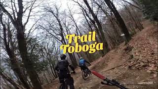
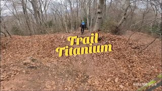
From Cascina Paradiso to Bocchetta di stivioni. Then Downhill riding Titanium Trail and Toboga ! Da...
★ 5.0 • 15 miles • 3,036 ft • 4 • Loop •
Long RIde in cuasso, From Villaggio Siba to Piambello . Then downhill to Boarezzo and road Transfer to...
★ 5.0 • 17 miles • 3,997 ft • 6 • Loop •
Percorso Gara Enduro Cup Lombardia 2018 PS 1 Tornello (Monte Scerè - Cuasso al Monte) PS 2 Punta Paradiso...
★ 5.0 • 18 miles • 4,137 ft • 9 •
Giro completo di tutti i trail sul versante di Cuasso al Monte
★ 5.0 • 27 miles • 2,643 ft • 5 •
Nice round trip that covers most of the Valganna
Photos of Cuasso al Monte Mountain Bike
Videos of Cuasso al Monte Mountain Bike
trail: Punta Paradiso-Messeguè
0:07 |
|
Feb 9, 2020

trail: Punta Paradiso-Messeguè
0:49 |
225 |
Jan 5, 2020
trail: Punta Paradiso-Messeguè
10:43 |
124 |
Jan 6, 2025 , Cuasso al Monte
trail: Monte Scerè-Punta Paradiso
8:19 |
108 |
Jan 6, 2025 , Cuasso al Monte

trail: Monte Scerè-Cuasso al Monte
13:39 |
171 |
Jan 6, 2025 , Cuasso al Monte

trail: Monte Scerè-Cuasso al Monte
11:16 |
122 |
Jul 28, 2024 , Cuasso al Monte

trail: Marziana DH
7:47 |
600 |
Dec 28, 2023 , Cuasso al Monte
trail: Happy Mountain
3:11 |
468 |
Jan 20, 2021 , Cuasso al Monte
Current Trail Warnings
| status | trail | date | condition | user | info |
|---|---|---|---|---|---|
| Marziana DH | Jun 12, 2026 @ 6:11pm (Europe/Rome) Jun 12, 2026 | Dry | pit907 | La barriera e il cartello sono ancora... |
Recent Trail Reports
Activity Feed
| username | action | type | title | date |
|---|---|---|---|---|
| AntonioKxFCtc | wishlist | route | activity #96953370 | Jun 14, 2026 @ 4:12am Jun 14, 2026 |
| pit907 | comment | report | activity #96810163 | Jun 12, 2026 @ 9:28am Jun 12, 2026 |
| pit907 | add | report | activity #96809033 | Jun 12, 2026 @ 9:11am Jun 12, 2026 |
| pit907 | add | trail | activity #96758957 | Jun 11, 2026 @ 1:37pm Jun 11, 2026 |
| DanielPzqIlh | comment | trail | activity #94885428 | May 17, 2026 @ 3:48am May 17, 2026 |
Recent Comments
| username | type | title | comment | date |
|---|---|---|---|---|
| report | P.S. Questo trail è tutto tranne che rosso:... | Jun 12, 2026 @ 9:28am Jun 12, 2026 | ||
| trail | Unfortunately, there's a roadblock with a... | May 17, 2026 @ 3:48am May 17, 2026 | ||
| report | riaperto? | May 3, 2026 @ 12:12am May 3, 2026 | ||
| trail | nelle condizioni attuali è difficile (nero)... | Mar 3, 2026 @ 9:00am Mar 3, 2026 | ||
| report | Semplice parte alta stanno tagliando alberi e... | Feb 14, 2026 @ 6:16am Feb 14, 2026 |
Local Badges
-

Epic Ride Climb 2k121 awarded -

Climbing 10k Badge40 awarded -

Climbing 100k Badge1 awarded -

Epic Ride Descent 2k128 awarded -

Descent 10k Badge39 awarded -

Descent 100k Badge1 awarded
Activity Type Stats
| activitytype | trails | distance | descent | descent distance | total vertical | rating | global rank | state rank | photos | reports | routes | ridelogs |
|---|---|---|---|---|---|---|---|---|---|---|---|---|
| Mountain Bike | 40 | 39 miles | 14,236 ft | 20 miles | 2,598 ft | #2,559 | #120 | 192 | 1,062 | 7 | 3,587 | |
| E-Bike | 37 | 37 miles | 12,822 ft | 18 miles | 2,598 ft | #561 | #56 | 2 | 1,052 | 4 | 805 | |
| Hike | 42 | 38 miles | 12,972 ft | 19 miles | 2,598 ft | #788 | #20 | 2 | 1,052 | 1 | 109 | |
| Trail Running | 40 | 36 miles | 12,162 ft | 18 miles | 2,598 ft | #2,604 | #78 | 1,050 | 37 |
Frequently Asked Questions About Cuasso al Monte
▼
What are the best places to ride in Cuasso al Monte?
Cuasso al Monte has 1 areas to explore for mountain biking. The top rated areas are:
▼
What are the highest rated mountain biking trails in Cuasso al Monte?
The highest rated mountain biking trails in Cuasso al Monte are:
- Happy Mountain (4.5/5)
- Monte Scerè-Cuasso al Monte (4.4/5)
- Monte Scerè-Punta Paradiso (4.4/5)
- Punta Paradiso-Messeguè (4.3/5)
- Piambello-Boarezzo (4.2/5)
▼
What is the best time of the year to ride in Cuasso al Monte?
Based on ride log data, the most popular months to ride in Cuasso al Monte are:
- April (22 activities)
- February (18 activities)
- September (18 activities)
▼
Where can I park to ride in Cuasso al Monte?
Activities
Trails
- By mattiabettagno & contributors
- Admins: marcoangeletti, adessoomaipiu, micheletraversi, adessoomaipiu, VBASD
- #11778 - 35,308 views
- cuasso al monte activity log | embed map of Cuasso al Monte mountain bike trails | cuasso al monte mountain biking points of interest
Downloading of trail gps tracks in kml & gpx formats is disabled for Cuasso al Monte.