close
-
Layers w
- Weather Layers
- Pro
- Pro
- Pro
- Pro
- Pro
- Pro
- More Layers
- Pro
- Pro
- Pro
- Pro
-
Upgrade to

3D
Trail Conditions
- Unknown
- Snow Groomed
- Snow Packed
- Snow Covered
- Snow Cover Partial
- Freeze/thaw Cycle
- Icy
- Prevalent Mud
- Wet
- Variable
- Ideal
- Dry
- Very Dry
Trail Flow (Ridden Direction)
Trailforks scans users ridelogs to determine the most popular direction each trail is ridden. A good flowing trail network will have most trails flowing in a single direction according to their intension.
The colour categories are based on what percentage of riders are riding a trail in its intended direction.
The colour categories are based on what percentage of riders are riding a trail in its intended direction.
- > 96%
- > 90%
- > 80%
- > 70%
- > 50%
- < 50%
- bi-directional trail
- no data
Trail Last Ridden
Trailforks scans ridelogs to determine the last time a trail was ridden.
- < 2 days
- < 1 week
- < 2 weeks
- < 1 month
- < 6 months
- > 6 months
Trail Ridden Direction
The intended direction a trail should be ridden.
- Downhill Only
- Downhill Primary
- Both Directions
- Uphill Primary
- Uphill Only
- One Direction
Contribute Details
Colors indicate trail is missing specified detail.
- Description
- Photos
- Description & Photos
- Videos
Trail Popularity ?
Trailforks scans ridelogs to determine which trails are ridden the most in the last 9 months.
Trails are compared with nearby trails in the same city region with a possible 25 colour shades.
Think of this as a heatmap, more rides = more kinetic energy = warmer colors.
- most popular
- popular
- less popular
- not popular
ATV/ORV/OHV Filter
Max Vehicle Width
inches
US Cell Coverage
Legend

Radar Time
Activity Recordings
Trailforks uses anonymized public activity data.
?
Activity Recordings
Trailforks uses anonymized public activity data.
?
Personal Heatmap
▶
Activity Types
all
/
none
▶
Options
2
Date range
month
–
Winter Trails
Warning
A routing network for winter maps does not exist. Selecting trails using the winter trails layer has been disabled.
Missing Trails
Most Popular
Least Popular
Trails are colored based on popularity. The more popular a trail is, the more red. Less popular trails trend towards green.
Jump Magnitude Heatmap
Heatmap of where riders jump on trails. Zoom in to see individual jumps, click circles to view jump details.
BC Backroad Status
![map legend]()
Service Road Atlas is a free to use, community-driven service for viewing and creating reports on the numerous back-country service roads around B.C. and Alberta.

Slope Aspect
Direction the slope faces
Trails Deemphasized
Trails are shown in grey.
Only show trails with no bike usage.
Suggested Layers
Based on selected activity type
Save the current map location and zoom level as your default home location whenever this page is loaded.
SaveCypress trails, for the most part, are unsanctioned, unmarked and the steepest, most technical trails on the North Shore.
Cypress trails lend themselves to be easily shuttled because of the road access, but there are also great riding loops to be found. You can create these loops using the BLT Trail as the main climbing route accessing all the trails on the mountain.
Cypress trails lend themselves to be easily shuttled because of the road access, but there are also great riding loops to be found. You can create these loops using the BLT Trail as the main climbing route accessing all the trails on the mountain.
Primary Trail Type: All-Mountain & Downhill
Shuttleable: YES
Land Status: Private Property
Land Manager: BPP
 google parking directions
 Access Info:
Take Highway 1 West from the Lions Gate Bridge or the Iron Worker's Memorial Bridge. Head west into West Vancouver heading toward Horseshoe Bay. Take Cypress Provincial Park exit, drive up Cypress Bowl Parkway approximately 2 km from highway. You will come to the West Vancouver works yard on your right with an antique road grader on the side of the road and a small gravel parking lot on the left. Park in the small lot on the left.
Files
- cypress-land-ownership.jpg (1.08 MB)
Activities Click to view
- Mountain Bike
78 trails
- E-Bike
68 trails
- Hike
74 trails
- Trail Running
74 trails
Region Details
- 12
- 1
- 10
- 24
- 16
- 2
Region Status
Caution as of Jun 19, 2026Stats
- Avg Trail Rating
- Trails (view details)
- 74
- Trails Mountain Bike
- 79
- Trails E-Bike
- 68
- Trails Hike
- 74
- Trails Trail Running
- 74
- Trails Snowshoe
- 2
- Trails Backcountry Ski
- 1
- Total Distance
- 33 miles
- Total Descent
- 22,679 ft
- Total Vertical
- 2,649 ft
- Highest Trailhead
- 2,801 ft
- Reports
- 5,935
- Photos
- 1,661
- Ridden Counter
- 45,766
Articles

Video: Steve Vanderhoek Revisits a Classic With Wild New Sends in '5IFTH... Again'
Jun 5, 2025 from pinkbike.com
What started as a fun reshoot of an old project turned into a six-month trail rebuild. Worth it.

Video: Miranda Miller is Calculated & Confident on Cypress Mountain's Treacherous Frozen Trails
Nov 19, 2020 from pinkbike.com
Miller makes easy work of Cypress Mountains on her Process X.
Win a Knolly Warden LT with the NSMBA 'Trails Forever' Bike Raffle
Jun 17, 2020 from pinkbike.com
Win a brand new custom-built Knolly bike while raising some money for the trails!
Popular Cypress Mountain Mountain Biking Trails
• 100 ★ 4.6 • 2,018 ft • 0 ft • 1,717 •
Natural continuation after . The upper section has multiple line options great for progressing skills for intermediate and expert riders. The trail has 14+ jumps varying from rollers that can be doubled to mandatory gaps that slowly...
• 95 ★ 4.2 • 2,815 ft • 12 ft • 1,548 •
Entrance is deliberately discreet. A natural trail that switchbacks its way between the . Follows the terrain rather than crossing it.
• 95 ★ 3.6 • 820 ft • 0 ft • 1,256 •
A short trail between a switchback on the . Alternate easy line to .
• 100 ★ 4.5 • 2,195 ft • 0 ft • 1,172 •
One of the most popular trails on cypress. World Cup training track, so don't hike on it or go slow down it. A bunch of nice berms with jumps and a couple of fast straight section. If you want to train for races on it, you should do to...
• 90 ★ 3.6 • 4,199 ft • 8 ft • 1,157 •
Starts flat going through the Conservancy before getting steeper with natural and some older man-made TTFs.
• 95 ★ 4.3 • 1,575 ft • 0 ft • 1,085 •
A natural technical trail containing many natural TTFs.
• 95 ★ 4.6 • 1 mile • 15 ft • 1,083 •
Very steep with steep mandatory rock features with high consequence sections. Contains natural and man-made TTFs. Not a beginners trail.
Cypress Mountain Mountain Bike Routes
5 miles • 1,443 ft • 9 • Loop •
This is a great pedal loop featuring the easier technical trails. The climb is up the fairly steep grade...
4 miles • 431 ft • 11 • Shuttled •
This is one of our favorite routes on the North Shore and is featured in Freehub Magazine's Sea to Sky...
2 miles • 83 ft • 0 • Shuttled •
GEC CLub ride descent #4...on Friday not a Thrus
• 24 miles • 4,146 ft • 6 •
• 24 miles • 3,390 ft • 3 •
Photos of Cypress Mountain Mountain Bike
Videos of Cypress Mountain Mountain Bike

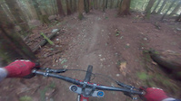
0:47 |
42 |
Jun 15, 2025

trail: 5th Horseman
0:17 |
136 |
Jul 21, 2024
trail: Upper Tall Cans
0:30 |
|
Mar 25, 2024
trail: Brutus
0:10 |
126 |
Dec 29, 2023

trail: Stupid Grouse
4:12 |
|
Oct 22, 2023
trail: Stupid Grouse
4:12 |
|
Oct 22, 2023

trail: Stupid Grouse
4:12 |
|
Oct 22, 2023
trail: Jersey Shore
4:42 |
68 |
Dec 4, 2022
Current Trail Warnings
| status | trail | date | condition | user | info |
|---|---|---|---|---|---|
| S&M | Jun 3, 2026 @ 2:12pm (America/Vancouver) Jun 3, 2026 | Dry | lushkiddy24 |
Recent Trail Reports
| status | trail | date | condition | info | user |
|---|---|---|---|---|---|
| Jersey Shore | Jun 14, 2026 @ 7:16pm (America/Vancouver) Jun 14, 2026 | Dry | Yaan Cypress | ||
| Mystery DH | Jun 11, 2026 @ 10:56am (America/Vancouver) Jun 11, 2026 | Ideal | Fonru | ||
| Mystery Old Exit | Jun 11, 2026 @ 10:56am (America/Vancouver) Jun 11, 2026 | Ideal | Fonru | ||
| Cypress East Climb Trail | Jun 11, 2026 @ 10:56am (America/Vancouver) Jun 11, 2026 | Ideal | Fonru | ||
| Meat Sweats | Jun 11, 2026 @ 10:56am (America/Vancouver) Jun 11, 2026 | Ideal | Fonru | ||
| Skid Mark | Jun 8, 2026 @ 5:48pm (America/Vancouver) Jun 8, 2026 | Variable | webhead | ||
| East Cypress Creek Trail | Jun 6, 2026 @ 3:20pm (America/Vancouver) Jun 6, 2026 | Unknown | Jackson2002 | ||
| S&M | Jun 3, 2026 @ 2:09pm (America/Vancouver) Jun 3, 2026 | Dry | lushkiddy24 | ||
| Sex Girl | Jun 3, 2026 @ 2:08pm (America/Vancouver) Jun 3, 2026 | Variable | lushkiddy24 | ||
| Morgies | Jun 1, 2026 @ 1:02pm (America/Vancouver) Jun 1, 2026 | Ideal | blackghostbike Cypress |
Activity Feed
| username | action | type | title | date |
|---|---|---|---|---|
| seanogorman | comment | trail | activity #97575396 | Jun 22, 2026 @ 11:33am 12 hours |
| agnostic | vote | trail | activity #97564802 and 3 more | Jun 22, 2026 @ 8:48am 15 hours |
| Klingy | wishlist | trail | activity #97541548 | Jun 21, 2026 @ 9:08pm 1 day |
| Klingy | ridden | trail | activity #97494182 | Jun 21, 2026 @ 9:40am 2 days |
| rlib | ridden | trail | activity #97157508 | Jun 16, 2026 @ 7:38pm Jun 16, 2026 |
Recent Comments
| username | type | title | comment | date |
|---|---|---|---|---|
| trail | Trail was redone with added features and a... | Jun 22, 2026 @ 11:33am 12 hours | ||
| report | Legend :) \m/ | Jun 9, 2026 @ 6:33pm Jun 9, 2026 | ||
| report | Very nice! Respect. | Jun 1, 2026 @ 10:26am Jun 1, 2026 | ||
| report | Thanks for your efforts. | May 31, 2026 @ 7:19pm May 31, 2026 | ||
| trail | Nutang now (May 2026) resurrected. All downed... | May 29, 2026 @ 8:43pm May 29, 2026 |
Nearby Areas
| name | distance | ||||
|---|---|---|---|---|---|
| Capilano River Regional Park | 4 | 1 | 4.3 km | ||
| Stanley Park | 1 | 4.7 km | |||
| Grouse Mountain Bike Park | 1 | 4 | 6 | 2 | 5.7 km |
| Grouse Mountain | 3 | 5.9 km | |||
| Greenwood Park | 6 | 2 | 6.9 km |
Local Badges
-

Completionist8 awarded
Local Products
Activity Type Stats
| activitytype | trails | distance | descent | descent distance | total vertical | rating | global rank | state rank | photos | reports | routes | ridelogs |
|---|---|---|---|---|---|---|---|---|---|---|---|---|
| Mountain Bike | 78 | 30 miles | 21,348 ft | 20 miles | 2,612 ft | #292 | #38 | 1,650 | 5,942 | 4 | 23,700 | |
| E-Bike | 68 | 5 miles | 1,063 ft | 2 miles | 2,014 ft | #1,939 | #66 | 4,698 | 842 | |||
| Hike | 74 | 27 miles | 15,837 ft | 16 miles | 2,648 ft | #452 | #31 | 2 | 5,433 | 1 | 1,021 | |
| Trail Running | 74 | 27 miles | 15,837 ft | 16 miles | 2,648 ft | #2,259 | #67 | 2 | 5,433 | 1 | 387 | |
| Snowshoe | 2 | 1,660 ft | 141 ft | 83 | 16 | |||||||
| Backcountry Ski | 1 | 1,165 ft | 108 ft | 8 | 83 | 12 |
Frequently Asked Questions About Cypress Mountain
▼
What are the highest rated mountain biking trails in Cypress Mountain?
The highest rated mountain biking trails in Cypress Mountain are:
- Never Never Land (4.6/5)
- 5th Horseman (4.5/5)
- Wutang (4.4/5)
- Meat Sweats (4.4/5)
- Jersey Shore (4.4/5)
▼
What is the best time of the year to ride in Cypress Mountain?
Based on ride log data, the most popular months to ride in Cypress Mountain are:
- July (302 activities)
- May (278 activities)
- June (243 activities)
▼
Where can I park to ride in Cypress Mountain?
There are 6 parking locations listed in Cypress Mountain. The most popular parking spots are: View all parking and trailhead locations on the map to plan your visit.
▼
What is the longest trail in Cypress Mountain?
The longest trail in Cypress Mountain is Cypress East Climb Trail at 2.6 km. View all trails sorted by distance.
Activities
Trails
Points of Interest
- By canadaka
 Trailforks & contributors
 - Admins: Cypress, NSMBA, SAR, ideguise, tedmorton, NSMBA, joewoywitka, sarahmc
- #21 - 146,974 views
- cypress mountain activity log | embed map of Cypress Mountain mountain bike trails | cypress mountain mountain biking points of interest polygons
Downloading of trail gps tracks in kml & gpx formats is enabled for Cypress Mountain.
You must login to download files.