close
-
Layers w
- Weather Layers
- Pro
- Pro
- Pro
- Pro
- Pro
- Pro
- More Layers
- Pro
- Pro
- Pro
- Pro
-
Upgrade to

3D
Trail Conditions
- Unknown
- Snow Groomed
- Snow Packed
- Snow Covered
- Snow Cover Partial
- Freeze/thaw Cycle
- Icy
- Prevalent Mud
- Wet
- Variable
- Ideal
- Dry
- Very Dry
Trail Flow (Ridden Direction)
Trailforks scans users ridelogs to determine the most popular direction each trail is ridden. A good flowing trail network will have most trails flowing in a single direction according to their intension.
The colour categories are based on what percentage of riders are riding a trail in its intended direction.
The colour categories are based on what percentage of riders are riding a trail in its intended direction.
- > 96%
- > 90%
- > 80%
- > 70%
- > 50%
- < 50%
- bi-directional trail
- no data
Trail Last Ridden
Trailforks scans ridelogs to determine the last time a trail was ridden.
- < 2 days
- < 1 week
- < 2 weeks
- < 1 month
- < 6 months
- > 6 months
Trail Ridden Direction
The intended direction a trail should be ridden.
- Downhill Only
- Downhill Primary
- Both Directions
- Uphill Primary
- Uphill Only
- One Direction
Contribute Details
Colors indicate trail is missing specified detail.
- Description
- Photos
- Description & Photos
- Videos
Trail Popularity ?
Trailforks scans ridelogs to determine which trails are ridden the most in the last 9 months.
Trails are compared with nearby trails in the same city region with a possible 25 colour shades.
Think of this as a heatmap, more rides = more kinetic energy = warmer colors.
- most popular
- popular
- less popular
- not popular
ATV/ORV/OHV Filter
Max Vehicle Width
inches
US Cell Coverage
Legend

Radar Time
Activity Recordings
Trailforks uses anonymized public activity data.
?
Activity Recordings
Trailforks uses anonymized public activity data.
?
Personal Heatmap
▶
Activity Types
all
/
none
▶
Options
2
Date range
month
–
Winter Trails
Warning
A routing network for winter maps does not exist. Selecting trails using the winter trails layer has been disabled.
Missing Trails
Most Popular
Least Popular
Trails are colored based on popularity. The more popular a trail is, the more red. Less popular trails trend towards green.
Jump Magnitude Heatmap
Heatmap of where riders jump on trails. Zoom in to see individual jumps, click circles to view jump details.
BC Backroad Status
![map legend]()
Service Road Atlas is a free to use, community-driven service for viewing and creating reports on the numerous back-country service roads around B.C. and Alberta.

Slope Aspect
Direction the slope faces
Trails Deemphasized
Trails are shown in grey.
Only show trails with no bike usage.
Suggested Layers
Based on selected activity type
Save the current map location and zoom level as your default home location whenever this page is loaded.
Save
No description for Dartmouth has been added yet!
Login or register to submit one.
Activities Click to view
- Mountain Bike
270 trails
- E-Bike
29 trails
- Gravel Bike
0 trails
- Adaptive Bike
0 trails
- Winter Fat Bike
0 trails
- Horse
6 trails
- Hike
248 trails
- Trail Running
247 trails
- Dirtbike/Moto
9 trails
- ATV/ORV/OHV
14 trails
- Snowmobile
5 trails
- Snowshoe
173 trails
- Nordic Ski
75 trails
Region Details
- 18
- 72
- 58
- 103
- 8
Region Status
Open as of 3 hoursLocal Trail Association
Stats
- Avg Trail Rating
- Trails (view details)
- 267
- Trails Mountain Bike
- 270
- Trails E-Bike
- 29
- Trails Horse
- 6
- Trails Hike
- 248
- Trails Trail Running
- 247
- Trails Dirtbike/Moto
- 9
- Trails ATV/ORV/OHV
- 14
- Trails Snowmobile
- 5
- Trails Snowshoe
- 173
- Trails Backcountry Ski
- 1
- Trails Nordic Ski
- 75
- Total Distance
- 100 miles
- Total Descent
- 8,542 ft
- Total Vertical
- 399 ft
- Highest Trailhead
- 399 ft
- Reports
- 1,646
- Photos
- 124
- Ridden Counter
- 10,652
Sub Regions
-
Birch Cove Park
- 1
- 4
-
Cyril Smith Golden Acres Park
- 2
- 11
-
Deer Trails
- 1
- 6
-
Shubie Park
- 23
- 10
- 11
-
Spectacle and Frenchman Lake Park
- 8
-
Spider Lake
- 5
- 8
-
The Farm at Topsail Lake
- 3
- 8
- 1
Popular Dartmouth Mountain Biking Trails
• 100 ★ 4.4 • 3 miles • 75 ft • 170 •
This is a multi-use active transportation trail. A few spots have a tendency to wash out in the spring, during heavy rain or melting. This section has no winter maintenance.
• 85 ★ 4.0 • 2,060 ft • 33 ft • 164 •
This trail has some rocks and technical sections, small climbs, and a few sweeping turns.
• 85 ★ 4.3 • 2,761 ft • 133 ft • 144 •
This trail is within the Lake Major Watershed Protected Water Area.
• 100 ★ 4.0 • 2 miles • 80 ft • 141 •
This is a multi-use active transportation trail. A few spots have a tendency to wash out in the spring, during heavy rain or melting. This section is plowed in winter.
• 100 ★ 5.0 • 421 ft • 25 ft • 138 •
Popular white difficulty family friendly gravel path. This multi-use trail can be used both directions. Trail visibility is always easy to follow. On average it takes 1 minutes to complete this trail.
Dartmouth Mountain Bike Routes
★ 4.0 • 15 miles • 334 ft • 2 • Out & Back •
The best route from downtown Dartmouth to Lawrencetown beach on 90% rail trail. Only one section of road,...
2 miles • 99 ft • 3 • Out & Back •
Get from downtown Dartmouth to Shubie Park. This route is mostly trails or paths and has the least amount...
68 miles • 1,812 ft • 14 •
110km long loop to the airport and back. Some of these trails are extremely wet and bogged out. Don't...
5 miles • 406 ft • 0 •
This is an out-and-back trail that will give you about 17km. What is shown is the main trail, but there...
• 15 miles • 935 ft • 14 •
• 4 miles • 204 ft • 6 •
Photos of Dartmouth Mountain Bike
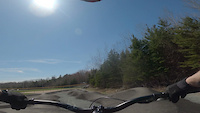
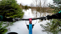
Videos of Dartmouth Mountain Bike
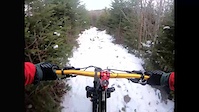
trail: My Humps
3:35 |
76 |
Jun 16, 2021
0:42 |
81 |
Apr 30, 2021
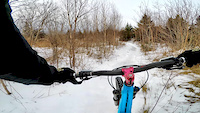
trail: Replicator
3:03 |
140 |
Mar 7, 2019
trail: Replicator
3:09 |
97 |
Mar 2, 2019
trail: Replicator
0:15 |
255 |
Jan 28, 2019
trail: Skull Trail
0:15 |
303 |
May 18, 2018
trail: Skull Trail
0:06 |
183 |
Feb 27, 2018
trail: Skull Trail
0:38 |
501 |
Dec 3, 2016
Recent Trail Reports
| status | trail | date | condition | info | user |
|---|---|---|---|---|---|
| Portland Lakes Greenway | Jun 18, 2026 @ 10:03am (America/Halifax) 3 hours | Ideal | SkidsRagnar | ||
| Mt Hope Greenway | Jun 18, 2026 @ 10:03am (America/Halifax) 3 hours | Ideal | SkidsRagnar | ||
| Shubie AT trail | Feb 1, 2026 @ 3:06pm (America/Halifax) Feb 1, 2026 | Variable | bent6543 TRAILFORKS | ||
| Shubie Path | Jan 10, 2026 @ 12:08pm (America/Halifax) Jan 10, 2026 | Wet | vwcabrio82 Gore Trails | ||
| South Doubletrack | Nov 29, 2025 @ 4:31pm (America/Halifax) Nov 29, 2025 | Variable | bent6543 TRAILFORKS | ||
| Shearwater Flyer Trail | Nov 19, 2025 @ 9:19am (America/Halifax) Nov 19, 2025 | Variable | SkidsRagnar | ||
| Framkies Farmall | Sep 6, 2025 @ 9:35am Sep 6, 2025 | Variable | ekmerrickk | ||
| Access Road | Sep 6, 2025 @ 9:35am Sep 6, 2025 | Variable | ekmerrickk | ||
| unnamed | Sep 6, 2025 @ 9:35am Sep 6, 2025 | Variable | ekmerrickk | ||
| Farmstead Flow | Sep 6, 2025 @ 9:35am Sep 6, 2025 | Variable | ekmerrickk |
Activity Feed
| username | action | type | title | date |
|---|---|---|---|---|
| SkidsRagnar | add | report | activity #97256560 and 1 more | Jun 18, 2026 @ 9:10am 10 mins |
| trailforks | add | video | activity #97020278 | Jun 14, 2026 @ 8:00pm Jun 14, 2026 |
| TtAYby | wishlist | trail | activity #96752616 | Jun 11, 2026 @ 11:46am Jun 11, 2026 |
| SkidsRagnar | add | report | activity #96159712 | Jun 3, 2026 @ 9:04am Jun 3, 2026 |
| rvnagy | ridden | trail | activity #95429076 | May 24, 2026 @ 11:19am May 24, 2026 |
Recent Comments
| username | type | title | comment | date |
|---|---|---|---|---|
| trail | Trail is reversed in Trailforks. | Oct 1, 2025 @ 5:41pm Oct 1, 2025 | ||
| trail | Trail is reversed in Trailforks. | Oct 1, 2025 @ 5:41pm Oct 1, 2025 | ||
| trail | lots up ups and downs.. Super fun! | May 14, 2024 @ 5:16am May 14, 2024 | ||
| trail | This is probably the most poorly designed... | Jul 28, 2021 @ 11:15am Jul 28, 2021 | ||
| trail | Agree with you both -- connections would be... | Jan 10, 2020 @ 5:24pm Jan 10, 2020 |
Local Badges
-

10 Green Trails67 awarded -

10 Blue Trails95 awarded -

Epic Ride Climb 2k6 awarded -

Climbing 10k Badge34 awarded -

Climbing 100k Badge0 awarded -

Epic Ride Descent 2k7 awarded
Bike & Skill Parks
| name | type | city | rating |
|---|---|---|---|
| Shubie Park Pump Track | skill park | Dartmouth | |
| Mt Edward | skill park | Dartmouth | |
| Miller Meadow MX Park | skill park | Dartmouth | |
| Dartmouth Skate Park | skill park | Dartmouth |
Activity Type Stats
| activitytype | trails | distance | descent | descent distance | total vertical | rating | global rank | state rank | photos | reports | routes | ridelogs |
|---|---|---|---|---|---|---|---|---|---|---|---|---|
| Mountain Bike | 270 | 88 miles | 6,585 ft | 36 miles | 400 ft | #963 | #3 | 123 | 1,645 | 4 | 10,142 | |
| E-Bike | 29 | 13 miles | 548 ft | 5 miles | 325 ft | #3,529 | #9 | 1,309 | 163 | |||
| Horse | 6 | 8 miles | 194 ft | 3 miles | 285 ft | #1,396 | #9 | 433 | 1 | |||
| Hike | 248 | 96 miles | 8,238 ft | 41 miles | 400 ft | #1,304 | #3 | 1,568 | 460 | |||
| Trail Running | 247 | 97 miles | 8,264 ft | 41 miles | 400 ft | #961 | #3 | 1 | 1,568 | 2,384 | ||
| Dirtbike/Moto | 9 | 11 miles | 354 ft | 4 miles | 308 ft | #677 | #5 | 498 | 28 | |||
| ATV/ORV/OHV | 14 | 15 miles | 417 ft | 6 miles | 351 ft | #529 | #7 | 508 | 4 | |||
| Snowmobile | 5 | 9 miles | 220 ft | 4 miles | 285 ft | #212 | #7 | 146 | ||||
| Snowshoe | 173 | 52 miles | 4,170 ft | 21 miles | 344 ft | #190 | #3 | 612 | 76 | |||
| Backcountry Ski | 1 | 5 miles | 167 ft | 3 miles | 236 ft | 1 | ||||||
| Nordic Ski | 75 | 31 miles | 2,477 ft | 12 miles | 344 ft | #455 | #4 | 584 | 4 |
Frequently Asked Questions About Dartmouth
▼
What are the best places to ride in Dartmouth?
Dartmouth has 13 areas to explore for mountain biking. The top rated areas are:
▼
What are the highest rated mountain biking trails in Dartmouth?
The highest rated mountain biking trails in Dartmouth are:
- Osprey Nest loop (4.3/5)
- Shearwater Flyer Trail (4.2/5)
- Meridian Court path (4.1/5)
- Farmstead Flow (4.1/5)
- Garland Ave Boardwalk (4.1/5)
▼
What is the best time of the year to ride in Dartmouth?
Based on ride log data, the most popular months to ride in Dartmouth are:
- July (170 activities)
- May (150 activities)
- August (118 activities)
▼
Where can I park to ride in Dartmouth?
There are 10 parking locations listed in Dartmouth. The most popular parking spots are: View all parking and trailhead locations on the map to plan your visit.
Activities
Trails
- By TheDaver
 & contributors
 - Admins: bent6543
- #4930 - 18,769 views
- dartmouth activity log | embed map of Dartmouth mountain bike trails | dartmouth mountain biking points of interest polygons
Downloading of trail gps tracks in kml & gpx formats is enabled for Dartmouth.
You must login to download files.