close
-
Layers w
- Weather Layers
- Pro
- Pro
- Pro
- Pro
- Pro
- Pro
- More Layers
- Pro
- Pro
- Pro
- Pro
-
Upgrade to

3D
Trail Conditions
- Unknown
- Snow Groomed
- Snow Packed
- Snow Covered
- Snow Cover Partial
- Freeze/thaw Cycle
- Icy
- Prevalent Mud
- Wet
- Variable
- Ideal
- Dry
- Very Dry
Trail Flow (Ridden Direction)
Trailforks scans users ridelogs to determine the most popular direction each trail is ridden. A good flowing trail network will have most trails flowing in a single direction according to their intension.
The colour categories are based on what percentage of riders are riding a trail in its intended direction.
The colour categories are based on what percentage of riders are riding a trail in its intended direction.
- > 96%
- > 90%
- > 80%
- > 70%
- > 50%
- < 50%
- bi-directional trail
- no data
Trail Last Ridden
Trailforks scans ridelogs to determine the last time a trail was ridden.
- < 2 days
- < 1 week
- < 2 weeks
- < 1 month
- < 6 months
- > 6 months
Trail Ridden Direction
The intended direction a trail should be ridden.
- Downhill Only
- Downhill Primary
- Both Directions
- Uphill Primary
- Uphill Only
- One Direction
Contribute Details
Colors indicate trail is missing specified detail.
- Description
- Photos
- Description & Photos
- Videos
Trail Popularity ?
Trailforks scans ridelogs to determine which trails are ridden the most in the last 9 months.
Trails are compared with nearby trails in the same city region with a possible 25 colour shades.
Think of this as a heatmap, more rides = more kinetic energy = warmer colors.
- most popular
- popular
- less popular
- not popular
ATV/ORV/OHV Filter
Max Vehicle Width
inches
US Cell Coverage
Legend

Radar Time
Activity Recordings
Trailforks uses anonymized public activity data.
?
Activity Recordings
Trailforks uses anonymized public activity data.
?
Personal Heatmap
▶
Activity Types
all
/
none
▶
Options
2
Date range
month
–
Winter Trails
Warning
A routing network for winter maps does not exist. Selecting trails using the winter trails layer has been disabled.
Missing Trails
Most Popular
Least Popular
Trails are colored based on popularity. The more popular a trail is, the more red. Less popular trails trend towards green.
Jump Magnitude Heatmap
Heatmap of where riders jump on trails. Zoom in to see individual jumps, click circles to view jump details.
BC Backroad Status
![map legend]()
Service Road Atlas is a free to use, community-driven service for viewing and creating reports on the numerous back-country service roads around B.C. and Alberta.

Slope Aspect
Direction the slope faces
Trails Deemphasized
Trails are shown in grey.
Only show trails with no bike usage.
Suggested Layers
Based on selected activity type
Save the current map location and zoom level as your default home location whenever this page is loaded.
Save
No description for Deem Hills has been added yet!
Login or register to submit one.

Primary Trail Type: Cross-Country
IMBA Ride Center
Valley of the Sun
Activities Click to view
- Mountain Bike
13 trails
- E-Bike
1 trails
- Horse
0 trails
- Hike
13 trails
- Trail Running
13 trails
Region Details
- 1
- 1
- 3
- 5
- 1
Region Status
Open as of Oct 20, 2025Local Trail Association
Stats
- Avg Trail Rating
- Trails (view details)
- 11
- Trails Mountain Bike
- 13
- Trails E-Bike
- 1
- Trails Hike
- 13
- Trails Trail Running
- 13
- Total Distance
- 12 miles
- Total Descent
- 1,570 ft
- Total Vertical
- 598 ft
- Highest Trailhead
- 2,035 ft
- Reports
- 66
- Photos
- 58
- Ridden Counter
- 2,645
Popular Deem Hills Mountain Biking Trails
• 45 ★ 3.8 • 2,392 ft • 142 ft • 237 •
Numerous wide switchbacks make there way up the side of the mountain, connecting with the upper mountain trails that are on the east side of the park. Also a good way to cut the loop in half if looking for a shorter outing.
• 20 ★ 2.0 • 187 ft • 0 ft • 190 •
The south end of that connects between Basalt and Circumference. This section descends north to south through some moderate switchbacks (not black diamond).
• 25 ★ 3.2 • 6 miles • 766 ft • 187 •
This loop has completely different difficulty levels and features depending where in the loop you are at and direction of travel. And rocks. Lots of rocks. - mileage based on elevation chart for reference (west parking lot) 0-1.4 mi:...
• 35 ★ 4.0 • 1 mile • 361 ft • 180 •
Not a summit trail... no amazing 360 deg view at the top if that is what you're looking for. On the other hand, an amazing workout trail in either direction for hiking/biking/trail running. North side of the mountain, good on warmer...
• 35 ★ 3.5 • 3,845 ft • 62 ft • 133 •
Less popular blue difficulty singletrack. This multi-use trail can be used both directions and has a moderate overall physical rating with a 62 ft blue climb. On average it takes 8 minutes to complete this trail.
• 30 ★ 3.5 • 2,370 ft • 6 ft • 125 •
Less popular blue difficulty singletrack. This multi-use trail can be used downhill primary and has a moderate overall physical rating with a 6 ft blue climb. On average it takes 4 minutes to complete this trail.
• 60 ★ 2.0 • 1 mile • 46 ft • 89 •
Moderately popular green difficulty singletrack. This multi-use trail can be used both directions. On average it takes 6 minutes to complete this trail.
Deem Hills Mountain Bike Routes
16 miles • 687 ft • 9 • Loop •
A pretty mellow Pyramid Peak/Paloma Loop with a minor street-riding finish. Not a lot of climbing, but a...
8 miles • 965 ft • 4 • Loop •
This is a good "training" ride to do solo or with a small group
• 6 miles • 703 ft • 4 •
• 6 miles • 882 ft • 7 •
• 5 miles • 5 •
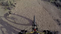
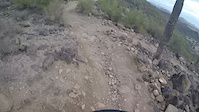
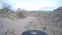
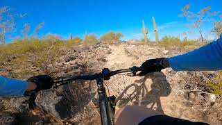
Photos of Deem Hills Mountain Bike
Videos of Deem Hills Mountain Bike
trail: Circumference
2:46 |
568 |
Jan 4, 2017
trail: Circumference
2:41 |
462 |
Dec 22, 2016
trail: Deem Hills Parkway
7:08 |
225 |
Dec 16, 2016
trail: Circumference
5:21 |
505 |
Dec 2, 2021 , Phoenix

540 |
Jul 11, 2017

trail: Circumference
1795 |
Jul 11, 2017 , Phoenix

trail: Ridgeline
1570 |
Jul 7, 2017 , Phoenix
Recent Trail Reports
| status | trail | date | condition | info | user |
|---|---|---|---|---|---|
| Circumference | Oct 20, 2025 @ 2:35am (America/Phoenix) Oct 20, 2025 | Ideal | Ampfrog | ||
| Nature Walk | Jul 5, 2025 @ 5:47am Jul 5, 2025 | Ideal | jt3mtb | ||
| Palisade - Circ Connector | Jan 21, 2025 @ 7:44pm Jan 21, 2025 | Very Dry | Ampfrog | ||
| Circumference Acc | Nov 12, 2024 @ 9:33pm Nov 12, 2024 | Dry | Ampfrog | ||
| Ridgeline | Oct 8, 2024 @ 7:07am Oct 8, 2024 | Ideal | garyclav | ||
| Basalt (West) | Oct 8, 2024 @ 7:07am Oct 8, 2024 | Ideal | garyclav | ||
| Basalt (Connect) | Oct 8, 2024 @ 7:07am Oct 8, 2024 | Ideal | garyclav | ||
| Basalt-Palisade | Oct 8, 2024 @ 7:07am Oct 8, 2024 | Ideal | garyclav | ||
| Deem Hills Loop | Feb 19, 2024 @ 2:50am Feb 19, 2024 | Ideal | Ampfrog | ||
| CAP Road Trail | Sep 11, 2023 @ 10:05am Sep 11, 2023 | Dry | 7SQTCwWN |
Activity Feed
| username | action | type | title | date |
|---|---|---|---|---|
| PeterkZ578t | ridden | trail | activity #89391047 | Feb 22, 2026 @ 4:14pm Feb 22, 2026 |
| popculture | ridden | trail | activity #88709949 | Feb 10, 2026 @ 8:28pm Feb 10, 2026 |
| AndrewE4lOtB | ridden | trail | activity #86804687 | Jan 7, 2026 @ 10:26am Jan 7, 2026 |
| andrewfif | add | photo | activity #85780757 and 1 more | Dec 20, 2025 @ 6:57am Dec 20, 2025 |
| JacobPetersen | ridden | trail | activity #84818328 and 2 more | Nov 27, 2025 @ 12:29pm Nov 27, 2025 |
Recent Comments
| username | type | title | comment | date |
|---|---|---|---|---|
| trail | Things can definitely go bad here, even if... | Oct 20, 2025 @ 2:12am Oct 20, 2025 | ||
| trail | Compared to other blues in the valley, this is... | Jul 17, 2024 @ 7:31am Jul 17, 2024 | ||
| trail | If a trials rider or like slow mtb tech,... | Feb 19, 2024 @ 2:53am Feb 19, 2024 | ||
| trail | **Note: please fully read the "Section... | Dec 22, 2023 @ 2:18am Dec 22, 2023 | ||
| trail | Water Tank > Palisade is a nice ridable... | Jun 19, 2023 @ 4:32am Jun 19, 2023 |
Nearby Areas
| name | distance | ||||
|---|---|---|---|---|---|
| Pyramid Peak | 8 | 39 | 1 | 2 km | |
| East Wing Mountain Preserve | 2 | 4 | 3.4 km | ||
| Thunderbird | 5 | 8 | 4 | 2 | 3.5 km |
| Phoenix Sonoran Preserve | 16 | 17 | 2 | 1 | 4.3 km |
| Paloma Regional Preserve | 6 | 9 | 4 | 5.1 km |
Local Mountain Biking Directory
-
Emigos Bike Shop
![Emigos Bike Shop]()
-
Coach Kata
![Coach Kata]()
-
Spokes at South Mountain
![Spokes at South Mountain]()
-
Gnar Gnar toursShuttle Service
-
Bike Barn AzBike Shop
-
Gordy's BicyclesBike Shop
Activity Type Stats
| activitytype | trails | distance | descent | descent distance | total vertical | rating | global rank | state rank | photos | reports | routes | ridelogs |
|---|---|---|---|---|---|---|---|---|---|---|---|---|
| Mountain Bike | 13 | 12 miles | 1,572 ft | 5 miles | 597 ft | #7,980 | #3,097 | 56 | 66 | 2 | 4,490 | |
| E-Bike | 1 | 1 mile | 62 ft | 3,579 ft | 62 ft | #10,365 | #3,695 | 39 | 1 | 280 | ||
| Hike | 13 | 12 miles | 1,572 ft | 5 miles | 597 ft | #10,461 | #4,128 | 66 | 1 | 606 | ||
| Trail Running | 13 | 12 miles | 1,572 ft | 5 miles | 597 ft | #10,297 | #3,822 | 6 | 66 | 1 | 329 |
Frequently Asked Questions About Deem Hills
▼
What are the highest rated mountain biking trails in Deem Hills?
The highest rated mountain biking trails in Deem Hills are:
- Ridgeline (4/5)
- Basalt (West) (3.9/5)
- Palisade (3.9/5)
- Palisade Trail (3.9/5)
- Deem Hills Loop (3.8/5)
▼
What is the best time of the year to ride in Deem Hills?
Based on ride log data, the most popular months to ride in Deem Hills are:
- December (44 activities)
- January (41 activities)
- November (35 activities)
▼
Where can I park to ride in Deem Hills?
Check the Deem Hills trail map for trailhead and parking information. Community members regularly update access and parking details for trails in the area.
▼
What is the longest trail in Deem Hills?
The longest trail in Deem Hills is Circumference at 5.7 miles. View all trails sorted by distance.
Activities
- By schillingsworth
 TRAILFORKS HTA & contributors
 - Admins: GROAZ
- #5408 - 8,526 views
- deem hills activity log | embed map of Deem Hills mountain bike trails | deem hills mountain biking points of interest
Downloading of trail gps tracks in kml & gpx formats is enabled for Deem Hills.
You must login to download files.