close
-
Layers w
- Weather Layers
- Pro
- Pro
- Pro
- Pro
- Pro
- Pro
- More Layers
- Pro
- Pro
- Pro
- Pro
-
Upgrade to

3D
Trail Conditions
- Unknown
- Snow Groomed
- Snow Packed
- Snow Covered
- Snow Cover Partial
- Freeze/thaw Cycle
- Icy
- Prevalent Mud
- Wet
- Variable
- Ideal
- Dry
- Very Dry
Trail Flow (Ridden Direction)
Trailforks scans users ridelogs to determine the most popular direction each trail is ridden. A good flowing trail network will have most trails flowing in a single direction according to their intension.
The colour categories are based on what percentage of riders are riding a trail in its intended direction.
The colour categories are based on what percentage of riders are riding a trail in its intended direction.
- > 96%
- > 90%
- > 80%
- > 70%
- > 50%
- < 50%
- bi-directional trail
- no data
Trail Last Ridden
Trailforks scans ridelogs to determine the last time a trail was ridden.
- < 2 days
- < 1 week
- < 2 weeks
- < 1 month
- < 6 months
- > 6 months
Trail Ridden Direction
The intended direction a trail should be ridden.
- Downhill Only
- Downhill Primary
- Both Directions
- Uphill Primary
- Uphill Only
- One Direction
Contribute Details
Colors indicate trail is missing specified detail.
- Description
- Photos
- Description & Photos
- Videos
Trail Popularity ?
Trailforks scans ridelogs to determine which trails are ridden the most in the last 9 months.
Trails are compared with nearby trails in the same city region with a possible 25 colour shades.
Think of this as a heatmap, more rides = more kinetic energy = warmer colors.
- most popular
- popular
- less popular
- not popular
ATV/ORV/OHV Filter
Max Vehicle Width
inches
US Cell Coverage
Legend

Radar Time
Activity Recordings
Trailforks uses anonymized public activity data.
?
Activity Recordings
Trailforks uses anonymized public activity data.
?
Personal Heatmap
▶
Activity Types
all
/
none
▶
Options
2
Date range
month
–
Winter Trails
Warning
A routing network for winter maps does not exist. Selecting trails using the winter trails layer has been disabled.
Missing Trails
Most Popular
Least Popular
Trails are colored based on popularity. The more popular a trail is, the more red. Less popular trails trend towards green.
Jump Magnitude Heatmap
Heatmap of where riders jump on trails. Zoom in to see individual jumps, click circles to view jump details.
BC Backroad Status
![map legend]()
Service Road Atlas is a free to use, community-driven service for viewing and creating reports on the numerous back-country service roads around B.C. and Alberta.

Slope Aspect
Direction the slope faces
Trails Deemphasized
Trails are shown in grey.
Only show trails with no bike usage.
Suggested Layers
Based on selected activity type
Save the current map location and zoom level as your default home location whenever this page is loaded.
SaveThis region is Unsanctioned, Ride at your own Risk!
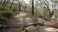
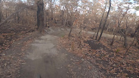
Mt Narra. Northern Beaches' main trail hub.
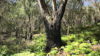
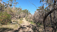
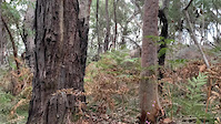
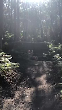
Full of tight, natural Sydney sandstone singletrack, incredible bushland and a gateway to the Garigal NP trails beyond. Although this isn't a very beginner-friendly area, it does, however, deliver for those looking for technical rocky adventures. Perfect place to start your all-day ride or just come for a quick lap or two after work.
Full of tight, natural Sydney sandstone singletrack, incredible bushland and a gateway to the Garigal NP trails beyond. Although this isn't a very beginner-friendly area, it does, however, deliver for those looking for technical rocky adventures. Perfect place to start your all-day ride or just come for a quick lap or two after work.
Primary Trail Type: All-Mountain & Downhill
eBikes Allowed:
Yes
Shuttleable: YES
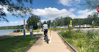
AKA: Deep Creek
Land Status: National Park
 google parking directions
 Access Info:
Deep Creek Carpark is the base for Mt Narra and surrounds, however you can also access off Mona Vale Road and Forest Way.
Activities Click to view
- Mountain Bike
31 trails
- E-Bike
11 trails
- Horse
0 trails
- Hike
29 trails
- Trail Running
29 trails
Region Details
- 3
- 1
- 3
- 9
- 11
- 4
Region Status
Open as of 24 hoursStats
- Avg Trail Rating
- Trails (view details)
- 32
- Trails Mountain Bike
- 31
- Trails E-Bike
- 11
- Trails Hike
- 29
- Trails Trail Running
- 29
- Total Distance
- 16 miles
- Total Descent
- 3,311 ft
- Total Vertical
- 406 ft
- Highest Trailhead
- 407 ft
- Reports
- 1,585
- Photos
- 259
- Ridden Counter
- 30,967
Popular Mt Narra Mountain Biking Trails
• 100 ★ 4.7 • 597 ft • 0 ft • 1,414 •
Highly rated popular black diamond difficulty singletrack. This mountain bike primary trail. It features drop and jump. On average it takes 1 minutes to complete this trail.
• 100 ★ 4.7 • 1,542 ft • 0 ft • 1,359 •
Highly rated popular black diamond difficulty singletrack. This mountain bike primary trail can be used downhill only and has a hard overall physical rating. It features drop, jump, gap jump and rock face. On average it takes 2 minutes to complete this trail.
• 100 ★ 4.7 • 1,066 ft • 0 ft • 1,303 •
Highly rated popular blue difficulty singletrack. This mountain bike primary trail can be used downhill only. It features drop and jump. On average it takes 4 minutes to complete this trail.
• 100 ★ 4.6 • 906 ft • 0 ft • 1,205 •
The start of Mt Narra Mainline often the next trail after will be . This trail has two upper features a Difficult roll and a Rock drop/Roll. This trail has been Adopted by Garigal Gorillas MTB who help maintain this trail. Dries quite...
• 95 ★ 4.5 • 1,152 ft • 0 ft • 1,147 •
Highly rated popular black diamond difficulty singletrack. This mountain bike primary trail can be used downhill only and has a hard overall physical rating. It features drop, jump, gap jump and rock garden. On average it takes 2 minutes to complete this trail.
• 90 ★ 3.0 • 1,142 ft • 12 ft • 1,131 •
Popular green difficulty singletrack. This mountain bike primary trail can be used both directions with a 12 ft blue climb. It features bridge. On average it takes 3 minutes to complete this trail.
• 100 ★ 4.5 • 735 ft • 0 ft • 968 •
Highly rated popular black diamond difficulty singletrack. This mountain bike primary trail can be used downhill only and has a hard overall physical rating. It features drop, jump and gap jump. On average it takes 4 minutes to complete this trail.
Mt Narra Mountain Bike Routes
★ 4.0 • 5 miles • 671 ft • 44 •
Quick Mt Narra loop starting from the Deep Creek car park, going over the deep creek bridge, going to the...
19 miles • 2,392 ft • 19 • Loop •
31 km loop from Mt Narra, over to Belrose, into the Cascades, up to Wildflowers, down Bunnings and back up...
2 miles • 590 ft • 5 • Loop •
Local ride with kids to meet, and ride with, Jack Moir
13 miles • 2,080 ft • 28 • Loop •
Back again for 2021 Ken's Enduro - better than ever! No faffing here we are straight into round 1, which...
6 miles • 662 ft • 27 • Out & Back •
Deep Creek spin out along creek for a warm up then up Vovvos and across the firetrails and back.
★ 4.0 • 4 miles • 698 ft • 6 • Loop •
Photos of Mt Narra Mountain Bike
Videos of Mt Narra Mountain Bike
trail: Loamsville
0:25 |
99 |
Sep 11, 2023
trail: Narrabeen Lake Trail
5:01 |
64 |
Oct 3, 2022
trail: Narrabeen Lake Trail
0:15 |
148 |
Aug 21, 2022
trail: Rampage
0:58 |
151 |
Nov 2, 2021
trail: Anchors
0:14 |
160 |
Oct 3, 2021

trail: Loamsville
0:16 |
68 |
Sep 25, 2021
trail: Ya Mum
0:07 |
524 |
Aug 30, 2021
trail: Narrabeen Lake Trail
0:09 |
306 |
Oct 21, 2020
Recent Trail Reports
| status | trail | date | condition | info | user |
|---|---|---|---|---|---|
| Narrabeen Lake Trail | Jun 24, 2026 @ 3:05pm (Australia/Sydney) 2 days | Ideal | MacroTiara | ||
| Sprocket | Jun 24, 2026 @ 3:05pm (Australia/Sydney) 2 days | Ideal | MacroTiara | ||
| Blackalicious | Jun 24, 2026 @ 3:05pm (Australia/Sydney) 2 days | Ideal | MacroTiara | ||
| King Brown Alley | Jun 24, 2026 @ 3:05pm (Australia/Sydney) 2 days | Ideal | MacroTiara | ||
| Voltz | Jun 24, 2026 @ 3:05pm (Australia/Sydney) 2 days | Dry | MacroTiara | ||
| Anchors | Jun 24, 2026 @ 3:05pm (Australia/Sydney) 2 days | Ideal | MacroTiara | ||
| Rampage Climb | Jun 24, 2026 @ 3:05pm (Australia/Sydney) 2 days | Ideal | MacroTiara | ||
| Rampage | Jun 24, 2026 @ 3:05pm (Australia/Sydney) 2 days | Ideal | MacroTiara | ||
| Beam Me Up | Jun 24, 2026 @ 3:05pm (Australia/Sydney) 2 days | Ideal | MacroTiara | ||
| Deep Creek Connect | Jun 24, 2026 @ 3:05pm (Australia/Sydney) 2 days | Ideal | MacroTiara |
Activity Feed
| username | action | type | title | date |
|---|---|---|---|---|
| MacroTiara | add | report | activity #97757087 and 9 more | Jun 25, 2026 @ 3:33am 24 hours |
| MacroTiara | add | photo | activity #97756975 and 6 more | Jun 25, 2026 @ 3:29am 24 hours |
| Lonestarmac | wishlist | trail | activity #95822818 | May 29, 2026 @ 9:26pm May 29, 2026 |
| ak0047 | difficultyvote | trail | activity #95756479 | May 28, 2026 @ 9:45pm May 28, 2026 |
| JacobNJ0eW4 | wishlist | trail | activity #95447801 | May 24, 2026 @ 2:52pm May 24, 2026 |
Recent Comments
| username | type | title | comment | date |
|---|---|---|---|---|
| trail | Wanting to level up your tech? Ridden Anchors... | Mar 11, 2026 @ 3:27pm Mar 11, 2026 | ||
| trail | Lots of work has gone in recently and it's... | Mar 11, 2026 @ 3:23pm Mar 11, 2026 | ||
| trail | Give it a few goes before you judge too much.... | Mar 11, 2026 @ 3:22pm Mar 11, 2026 | ||
| trail | Super fun, bits of flow but mainly super fun... | Mar 11, 2026 @ 3:19pm Mar 11, 2026 | ||
| trail | Hands down one of the most fun pieces of trail... | Mar 11, 2026 @ 3:17pm Mar 11, 2026 |
Nearby Areas
| name | distance | ||||
|---|---|---|---|---|---|
| Bahai | 2 | 4 | 2 | 1 | 1.7 km |
| Red Hill Reserve | 7 | 14 | 11 | 1 | 1.8 km |
| Mona Vale | 6 | 3 | 1 | 2 | 2 km |
| Oxford Falls | 7 | 4 | 4 | 2.1 km | |
| Twin Peaks | 3 | 3 | 2.6 km |
Local Badges
-

Completionist18 awarded
Activity Type Stats
| activitytype | trails | distance | descent | descent distance | total vertical | rating | global rank | state rank | photos | reports | routes | ridelogs |
|---|---|---|---|---|---|---|---|---|---|---|---|---|
| Mountain Bike | 31 | 16 miles | 3,064 ft | 8 miles | 407 ft | #170 | #17 | 259 | 1,580 | 6 | 31,800 | |
| E-Bike | 11 | 10 miles | 1,335 ft | 4 miles | 390 ft | #2,244 | #108 | 1,454 | 3,834 | |||
| Hike | 29 | 15 miles | 2,789 ft | 7 miles | 407 ft | #4,353 | #106 | 1,541 | 153 | |||
| Trail Running | 29 | 15 miles | 2,789 ft | 7 miles | 407 ft | #3,142 | #79 | 1,542 | 1,907 |
Frequently Asked Questions About Mt Narra
▼
What are the highest rated mountain biking trails in Mt Narra?
The highest rated mountain biking trails in Mt Narra are:
- Rockn Robyn (4.6/5)
- Anchors (4.5/5)
- King Brown Alley (4.5/5)
- Ya Mum (4.5/5)
- Blackalicious (4.5/5)
▼
What is the best time of the year to ride in Mt Narra?
Based on ride log data, the most popular months to ride in Mt Narra are:
- July (169 activities)
- January (109 activities)
- August (100 activities)
▼
Where can I park to ride in Mt Narra?
There are 5 parking locations listed in Mt Narra. The most popular parking spots are: View all parking and trailhead locations on the map to plan your visit.
▼
What is the longest trail in Mt Narra?
The longest trail in Mt Narra is Narrabeen Lake Trail at 8.5 km. View all trails sorted by distance.
Activities
Trails
- By brenthillier
 NSMBA TRAILFORKS & contributors
 - Admins: TrailCare
- #9758 - 50,619 views
- mt narra activity log | embed map of Mt Narra mountain bike trails | mt narra mountain biking points of interest
Downloading of trail gps tracks in kml & gpx formats is enabled for Mt Narra.
You must login to download files.