close
-
Layers w
- Weather Layers
- Pro
- Pro
- Pro
- Pro
- Pro
- Pro
- More Layers
- Pro
- Pro
- Pro
- Pro
-
Upgrade to

3D
Trail Conditions
- Unknown
- Snow Groomed
- Snow Packed
- Snow Covered
- Snow Cover Partial
- Freeze/thaw Cycle
- Icy
- Prevalent Mud
- Wet
- Variable
- Ideal
- Dry
- Very Dry
Trail Flow (Ridden Direction)
Trailforks scans users ridelogs to determine the most popular direction each trail is ridden. A good flowing trail network will have most trails flowing in a single direction according to their intension.
The colour categories are based on what percentage of riders are riding a trail in its intended direction.
The colour categories are based on what percentage of riders are riding a trail in its intended direction.
- > 96%
- > 90%
- > 80%
- > 70%
- > 50%
- < 50%
- bi-directional trail
- no data
Trail Last Ridden
Trailforks scans ridelogs to determine the last time a trail was ridden.
- < 2 days
- < 1 week
- < 2 weeks
- < 1 month
- < 6 months
- > 6 months
Trail Ridden Direction
The intended direction a trail should be ridden.
- Downhill Only
- Downhill Primary
- Both Directions
- Uphill Primary
- Uphill Only
- One Direction
Contribute Details
Colors indicate trail is missing specified detail.
- Description
- Photos
- Description & Photos
- Videos
Trail Popularity ?
Trailforks scans ridelogs to determine which trails are ridden the most in the last 9 months.
Trails are compared with nearby trails in the same city region with a possible 25 colour shades.
Think of this as a heatmap, more rides = more kinetic energy = warmer colors.
- most popular
- popular
- less popular
- not popular
ATV/ORV/OHV Filter
Max Vehicle Width
inches
US Cell Coverage
Legend

Radar Time
Activity Recordings
Trailforks uses anonymized public activity data.
?
Activity Recordings
Trailforks uses anonymized public activity data.
?
Personal Heatmap
▶
Activity Types
all
/
none
▶
Options
2
Date range
month
–
Winter Trails
Warning
A routing network for winter maps does not exist. Selecting trails using the winter trails layer has been disabled.
Missing Trails
Most Popular
Least Popular
Trails are colored based on popularity. The more popular a trail is, the more red. Less popular trails trend towards green.
Jump Magnitude Heatmap
Heatmap of where riders jump on trails. Zoom in to see individual jumps, click circles to view jump details.
BC Backroad Status
![map legend]()
Service Road Atlas is a free to use, community-driven service for viewing and creating reports on the numerous back-country service roads around B.C. and Alberta.

Slope Aspect
Direction the slope faces
Trails Deemphasized
Trails are shown in grey.
Only show trails with no bike usage.
Suggested Layers
Based on selected activity type
Save the current map location and zoom level as your default home location whenever this page is loaded.
Save
No description for Denver has been added yet!
Login or register to submit one.
Activities Click to view
- Mountain Bike
214 trails
- Hike
230 trails
- Trail Running
230 trails
Region Details
- 2
- 11
- 166
- 32
- 2
- 1
Region Status
Open as of Jun 7, 2026Stats
- Avg Trail Rating
- Global Ranking
- #888
- State Ranking
- #349
- Trails (view details)
- 228
- Trails Mountain Bike
- 214
- Trails E-Bike
- 2
- Trails Hike
- 230
- Trails Trail Running
- 230
- Total Distance
- 23 miles
- Total Descent
- 798 ft
- Total Vertical
- 231 ft
- Highest Trailhead
- 5,479 ft
- Reports
- 119
- Photos
- 55
- Ridden Counter
- 11,394
Articles
The Best Summer Weekend Trips of 2025
Jun 3, 2025 from outsideonline.com
There are only 14 weekends between Memorial Day and Labor Day this year. So you better make them count.

Featured Speakers Announced for the 2025 Outside Festival
Apr 2, 2025 from pinkbike.com
Come see Emily Harrington, Selema Masekela, Rebecca Rusch, Jim Morrison, Alex Honnold, Kimmy Fasani, Matt Lyons, and many more this summer at the...

Outside Summit Announces Featured 2025 Speakers
Jan 31, 2025 from pinkbike.com
Join global leaders and emerging voices at the networking event of the year for outdoor industry professionals.

Outside Summit Announces Featured 2025 Speakers
Jan 31, 2025 from pinkbike.com
Join global leaders and emerging voices at the networking event of the year for outdoor industry professionals.
Sub Regions
-
Bluff Lake Nature Center
- 159
- 30
-
Cheesman Park
- 2
-
Ruby Hill Bike Park
- 2
- 5
- 2
- 2
- 1
-
Washington Park
- 5
Popular Denver Mountain Biking Trails
• 90 ★ 5.0 • 735 ft • 0 ft • 670 •
Popular green difficulty singletrack. This mountain bike primary trail can be used downhill only. It features berm and jump. On average it takes 2 minutes to complete this trail.
• 80 ★ 4.0 • 822 ft • 1 ft • 664 •
Popular blue difficulty singletrack. This mountain bike primary trail can be used downhill only. On average it takes 3 minutes to complete this trail.
• 95 ★ 5.0 • 771 ft • 0 ft • 659 •
Popular green difficulty singletrack. This mountain bike primary trail can be used downhill only. It features berm. On average it takes 2 minutes to complete this trail.
• 70 ★ 5.0 • 743 ft • 0 ft • 637 •
Popular double black diamond difficulty singletrack. This mountain bike primary trail can be used downhill only. It features jump, gap jump and wallride. On average it takes 2 minutes to complete this trail.
• 80 ★ 5.0 • 782 ft • 0 ft • 586 •
Popular black diamond difficulty singletrack. This mountain bike primary trail can be used downhill only. On average it takes 1 minutes to complete this trail.
• 85 ★ 0.0 • 1 mile • 22 ft • 581 •
Popular white difficulty paved path. This multi-use trail can be used both directions. On average it takes 5 minutes to complete this trail.
• 100 ★ 4.0 • 542 ft • 5 ft • 576 •
Popular black diamond difficulty singletrack. This mountain bike primary trail can be used both directions. It features jump and gap jump. On average it takes 2 minutes to complete this trail.
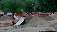
Photos of Denver Mountain Bike
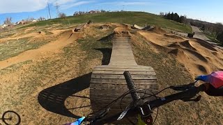
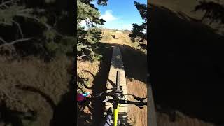
Videos of Denver Mountain Bike

trail: Ruby Hill XC
0:14 |
452 |
Nov 27, 2018
0:16 |
5866 |
Jun 16, 2016
trail: Slopestyle XL
10:08 |
597 |
May 9, 2021 , Denver

trail: Slopestyle L
10:08 |
883 |
May 9, 2021 , Denver
trail: Slopestyle L
0:35 |
629 |
Apr 15, 2021 , Denver

4:39 |
587 |
Jun 1, 2018
4:39 |
413 |
Jun 1, 2018

4:45 |
261 |
Jun 1, 2018
Recent Trail Reports
| status | trail | date | condition | info | user |
|---|---|---|---|---|---|
| Main Loop | Jun 7, 2026 @ 9:18am (America/Denver) Jun 7, 2026 | Ideal | Grendel65 | ||
| Sand Creek Trail | May 31, 2026 @ 10:35am (America/Denver) May 31, 2026 | Ideal | Grendel65 | ||
| Ruby Hill XC | May 22, 2026 @ 5:05pm (America/Denver) May 22, 2026 | Ideal | mleighton | ||
| Mary Carter Greenway | May 9, 2026 @ 11:15am (America/Denver) May 9, 2026 | Dry | mleighton | ||
| Slopestyle L | May 8, 2026 @ 4:14pm (America/Denver) May 8, 2026 | Dry | mleighton | ||
| Ruby Hill Park | May 1, 2026 @ 4:50pm (America/Denver) May 1, 2026 | Dry | mleighton | ||
| Ruby Hill Upper Return | Sep 2, 2024 @ 11:53am Sep 2, 2024 | Dry | leviathan1976 | ||
| Dirt Jumps M | Sep 2, 2024 @ 11:53am Sep 2, 2024 | Dry | leviathan1976 | ||
| Slopestyle S | Sep 2, 2024 @ 11:53am Sep 2, 2024 | Dry | leviathan1976 | ||
| Slopestyle XS | Sep 2, 2024 @ 11:53am Sep 2, 2024 | Dry | leviathan1976 |
Activity Feed
| username | action | type | title | date |
|---|---|---|---|---|
| Grendel65 | add | report | activity #96485945 | Jun 7, 2026 @ 12:06pm Jun 7, 2026 |
| Gushue3 | wishlist | trail | activity #96216523 | Jun 4, 2026 @ 4:23am Jun 4, 2026 |
| Grendel65 | add | report | activity #95981232 | May 31, 2026 @ 3:08pm May 31, 2026 |
| mleighton | add | report | activity #95281446 | May 22, 2026 @ 6:01pm May 22, 2026 |
| TessaTjWEi3 | wishlist | region | activity #95253207 | May 22, 2026 @ 10:32am May 22, 2026 |
Recent Comments
| username | type | title | comment | date |
|---|---|---|---|---|
| trail | Free ride lines like valemont. This place is... | May 1, 2023 @ 10:55am May 1, 2023 | ||
| trail | THIS IS A PAVED MULTIUSE TRAIL. IT IS NOT A... | Jun 24, 2020 @ 4:29pm Jun 24, 2020 | ||
| report | Ggg | Jun 4, 2020 @ 11:13am Jun 4, 2020 | ||
| trail | This is a great loop to do if youre a newer... | Sep 12, 2019 @ 7:07pm Sep 12, 2019 |
Local Badges
-

Outside Fest - Pump Track Challenge15 awarded -

Epic Ride Climb 2k9 awarded -

Climbing 10k Badge58 awarded -

Climbing 100k Badge0 awarded -

Epic Ride Descent 2k8 awarded -

Descent 10k Badge58 awarded
Bike & Skill Parks
| name | type | city | rating |
|---|---|---|---|
| Ruby Hill Bike Park | skill park | Denver | |
| Trestle Bike Skills Course At Barnum North Park | skill park | Denver |
Activity Type Stats
| activitytype | trails | distance | descent | descent distance | total vertical | rating | global rank | state rank | photos | reports | routes | ridelogs |
|---|---|---|---|---|---|---|---|---|---|---|---|---|
| Mountain Bike | 214 | 14 miles | 689 ft | 4 miles | 230 ft | #888 | #349 | 55 | 119 | 41,510 | ||
| E-Bike | 2 | 2 miles | 79 ft | 3,556 ft | 112 ft | 101 | 1,400 | |||||
| Hike | 230 | 23 miles | 797 ft | 6 miles | 230 ft | #1,250 | #575 | 119 | 1 | 1,007 | ||
| Trail Running | 230 | 23 miles | 797 ft | 6 miles | 230 ft | #1,594 | #548 | 119 | 1 | 8,282 |
Frequently Asked Questions About Denver
▼
What are the best places to ride in Denver?
Denver has 6 areas to explore for mountain biking. The top rated areas are:
▼
What are the highest rated mountain biking trails in Denver?
The highest rated mountain biking trails in Denver are:
- Slopestyle XL (4.2/5)
- Slopestyle S (4.2/5)
- Slopestyle XS (4.1/5)
- Slopestyle L (4.1/5)
- Slopestyle M (4/5)
▼
What is the best time of the year to ride in Denver?
Based on ride log data, the most popular months to ride in Denver are:
- July (128 activities)
- August (73 activities)
- September (54 activities)
▼
Where can I park to ride in Denver?
There are 8 parking locations listed in Denver. The most popular parking spots are:
- 2350 W 8th Avenue Trailhead
- Overland Pond Park
- Ruby Hill Park
- Buffalo Mesa
- Platte River Trailhead (East 88th Ave)
Trails
- By brenthillier
 NSMBA TRAILFORKS & contributors
 - Admins: COMBA
- #4129 - 26,716 views
- denver activity log | embed map of Denver mountain bike trails | denver mountain biking points of interest
Downloading of trail gps tracks in kml & gpx formats is enabled for Denver.
You must login to download files.