close
-
Layers w
- Weather Layers
- Pro
- Pro
- Pro
- Pro
- Pro
- Pro
- More Layers
- Pro
- Pro
- Pro
- Pro
-
Upgrade to

3D
Trail Conditions
- Unknown
- Snow Groomed
- Snow Packed
- Snow Covered
- Snow Cover Partial
- Freeze/thaw Cycle
- Icy
- Prevalent Mud
- Wet
- Variable
- Ideal
- Dry
- Very Dry
Trail Flow (Ridden Direction)
Trailforks scans users ridelogs to determine the most popular direction each trail is ridden. A good flowing trail network will have most trails flowing in a single direction according to their intension.
The colour categories are based on what percentage of riders are riding a trail in its intended direction.
The colour categories are based on what percentage of riders are riding a trail in its intended direction.
- > 96%
- > 90%
- > 80%
- > 70%
- > 50%
- < 50%
- bi-directional trail
- no data
Trail Last Ridden
Trailforks scans ridelogs to determine the last time a trail was ridden.
- < 2 days
- < 1 week
- < 2 weeks
- < 1 month
- < 6 months
- > 6 months
Trail Ridden Direction
The intended direction a trail should be ridden.
- Downhill Only
- Downhill Primary
- Both Directions
- Uphill Primary
- Uphill Only
- One Direction
Contribute Details
Colors indicate trail is missing specified detail.
- Description
- Photos
- Description & Photos
- Videos
Trail Popularity ?
Trailforks scans ridelogs to determine which trails are ridden the most in the last 9 months.
Trails are compared with nearby trails in the same city region with a possible 25 colour shades.
Think of this as a heatmap, more rides = more kinetic energy = warmer colors.
- most popular
- popular
- less popular
- not popular
ATV/ORV/OHV Filter
Max Vehicle Width
inches
US Cell Coverage
Legend

Radar Time
Activity Recordings
Trailforks uses anonymized public activity data.
?
Activity Recordings
Trailforks uses anonymized public activity data.
?
Personal Heatmap
▶
Activity Types
all
/
none
▶
Options
2
Date range
month
–
Winter Trails
Warning
A routing network for winter maps does not exist. Selecting trails using the winter trails layer has been disabled.
Missing Trails
Most Popular
Least Popular
Trails are colored based on popularity. The more popular a trail is, the more red. Less popular trails trend towards green.
Jump Magnitude Heatmap
Heatmap of where riders jump on trails. Zoom in to see individual jumps, click circles to view jump details.
BC Backroad Status
![map legend]()
Service Road Atlas is a free to use, community-driven service for viewing and creating reports on the numerous back-country service roads around B.C. and Alberta.

Slope Aspect
Direction the slope faces
Trails Deemphasized
Trails are shown in grey.
Only show trails with no bike usage.
Suggested Layers
Based on selected activity type
Save the current map location and zoom level as your default home location whenever this page is loaded.
SaveDibër County is one of the 12 counties of the Republic of Albania, spanning a surface area of 2,586 square kilometres (998 sq mi) with the capital in Peshkopi. The county borders on the counties of Durrës, Elbasan, Kukës, Lezhë, Tirana and the country of North Macedonia. It is divided into the four municipalities of Bulqizë, Dibër, Klos and Mat. The municipalities are further subdivided into 290 towns and villages in total.
Topographically, the county is dominated by mountainous and high terrain, with a great variety of natural features including valleys, canyons, gorges, rivers, glacial lakes and dense forests. Various mountains ranging between 1,500 and 2,700 metres (4,921 and 8,858 ft) meters above sea level run the length of the county from north to south, including the Korab mountains in the east with Mali i Gramës and Korab at an altitude of 2,764 metres (9,068 ft) being the highest mountain in the county and as well as in Albania. The Dejë mountain 2,245 metres (7,365 ft) rises in the center, while in the east the county is dominatet by the Lura mountains. The Skanderbeg mountains on the west separates the Central Mountain Range with the Western Lowlands. The county, marked by a significant biological diversity, is water-rich with a dense river network, a rich aquifer system, and significant karst underground watercourses. It is home to the source of the river Mat which rises in Martanesh. Besides the Mat, the Drin river is an important waterway in the region.he county territory covers four distinct climatic types as of the Köppen climate classification; oceanic, continental, mediterranean and subarctic.[Located in the interior of Albania, the climate is mediterranean with continental influences. Mean monthly temperature ranges between −20 °C (−4 °F) (in January) and 25–30 °C (77–86 °F) (in July). Mean annual precipitation ranges between 600 millimetres (24 inches) and 1,000 millimetres (39 inches) depending on geographic region and prevailing climate type.
Dibër is an historically homogeneous county. Its capital and most populous city is Peshkopi. Tourism is one of the most important sectors in the county and has the largest potential to be a source for sustainable income, due to its natural and cultural heritage. Although the county has abundant natural resources like chromium, sulfur and marble. Dibër is predominantly an agriculture county. Agriculture mainly produces fruits and vegetables.
Region Details
- 16
- 8
- 37
- 9
Stats
- Avg Trail Rating
- Trails (view details)
- 72
- Trails Mountain Bike
- 71
- Trails E-Bike
- 71
- Trails Horse
- 26
- Trails Hike
- 75
- Trails Trail Running
- 74
- Trails Dirtbike/Moto
- 12
- Trails Observed Trials
- 11
- Trails ATV/ORV/OHV
- 14
- Trails Snowmobile
- 3
- Trails Snowshoe
- 2
- Trails Backcountry Ski
- 1
- Total Distance
- 173 miles
- Total Descent
- 76,437 ft
- Total Vertical
- 6,561 ft
- Highest Trailhead
- 7,743 ft
- Reports
- 3
- Photos
- 62
- Ridden Counter
- 127
Popular Dibër Mountain Biking Trails
• 5 ★ 4.8 • 2 miles • 19 ft • 8 •
Less popular blue difficulty alpine singletrack. This mountain bike primary trail and has a moderate overall physical rating. It features berm, drop, rock face and rock garden. Trail visibility is always easy to follow. On average it takes 25 minutes to complete this trail.
• 5 ★ 3.0 • 1 mile • 34 ft • 7 •
Less popular blue difficulty alpine singletrack. This mountain bike primary trail can be used downhill only and has a hard overall physical rating. It features berm and rock garden. Trail visibility is always easy to follow. On average it takes 17 minutes to complete this trail.
• ★ 4.0 • 2 miles • 242 ft • 7 •
Blue difficulty singletrack. This mountain bike primary trail can be used both directions and has a moderate overall physical rating with a 242 ft blue climb. Trail visibility is always easy to follow. On average it takes 30 minutes to complete this trail.
• 5 ★ 3.4 • 4 miles • 51 ft • 5 •
This trail has been reconstructed as part of a cross-border project between Albania and North Macedonia. It has been cured to the details, so watch out for the many hidden features to get the most fun out of it.
• 5 ★ 0.0 • 1 mile • 0 ft • 2 •
Less popular blue difficulty mixed. This mountain bike primary trail can be used downhill primary and has a moderate overall physical rating with a 0 ft black diamond climb. Trail visibility is sometimes hard to follow. On average it takes 16 minutes to complete this trail.
• 5 ★ 0.0 • 3 miles • 239 ft • 2 •
Less popular blue difficulty mixed. This mountain bike primary trail can be used both directions and has a hard overall physical rating with a 239 ft blue climb. Trail visibility is always easy to follow. On average it takes 36 minutes to complete this trail.
• 5 ★ 0.0 • 3 miles • 31 ft • 2 •
Less popular blue difficulty alpine singletrack. This mountain bike primary trail can be used downhill only and has a moderate overall physical rating. It features berm. Trail visibility is always easy to follow.
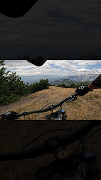
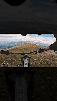
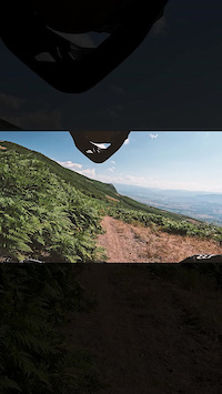
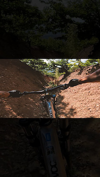
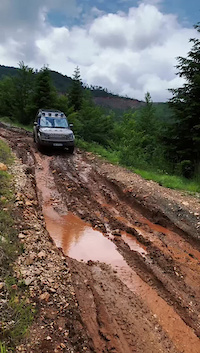
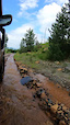
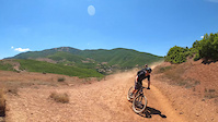
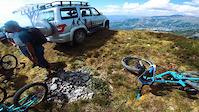
Photos of Dibër Mountain Bike
Videos of Dibër Mountain Bike
0:18 |
19 |
Aug 17, 2023
trail: Hinoskë - Maja e Velivarit
0:15 |
31 |
Aug 17, 2023
0:09 |
14 |
Aug 17, 2023
0:18 |
20 |
Aug 17, 2023
trail: Liqeni i Zi i Valikardhës
0:18 |
49 |
Jun 22, 2023
trail: Liqeni i Zi i Valikardhës
0:12 |
25 |
Jun 22, 2023
trail: Moab of Albania
0:36 |
|
Mar 7, 2023
trail: Hinoske - Ilnice Trail
0:48 |
|
Nov 23, 2021
Recent Trail Reports
| status | trail | date | condition | info | user |
|---|---|---|---|---|---|
| Moab of Albania Luzni-Bulaç natural park | Aug 20, 2024 @ 12:56pm Aug 20, 2024 | Ideal | eli_webi | ||
| Hinoske - Ilnice Trail Korab-Koritnik Nature Park | Oct 6, 2023 @ 6:32am Oct 6, 2023 | Dry | Benediktujrc4 | ||
| Pejke - Hotesh Trail Peshkopi | Aug 13, 2023 @ 8:50am Aug 13, 2023 | Dry | outfaced KrivaSpitsa |
Activity Feed
| username | action | type | title | date |
|---|---|---|---|---|
| Bikios | wishlist | trail | activity #96592082 | Jun 9, 2026 @ 2:16am Jun 9, 2026 |
| lane6riders | wishlist | trail | activity #86789061 and 2 more | Jan 7, 2026 @ 3:44am Jan 7, 2026 |
| andiqyqja | add | photo | activity #79552290 and 5 more | Sep 3, 2025 @ 7:25am Sep 3, 2025 |
| andiqyqja | add | trail | activity #79549786 and 1 more | Sep 3, 2025 @ 6:38am Sep 3, 2025 |
| andiqyqja | add | photo | activity #78926147 and 12 more | Aug 25, 2025 @ 11:02am Aug 25, 2025 |
Recent Comments
| username | type | title | comment | date |
|---|---|---|---|---|
| trail | Quite flowy. It kinda feels like freeriding,... | Aug 20, 2024 @ 12:59pm Aug 20, 2024 | ||
| trail | Flowtrail, beautiful, scenic! | Jun 27, 2024 @ 9:33am Jun 27, 2024 | ||
| trail | Amazing nature, wild and originally. | Oct 5, 2023 @ 6:51am Oct 5, 2023 | ||
| trail | Super scenic and flowy upper part on the edge... | Oct 5, 2023 @ 6:49am Oct 5, 2023 |
Local Badges
-

Completionist0 awarded -

10 Blue Trails0 awarded -

Epic Mountain Bike Climb 2k9 awarded -

Climbing 10k Badge0 awarded -

Mountain Biking 100k Badge0 awarded -

Epic Ride Descent 2k9 awarded
Activity Type Stats
| activitytype | trails | distance | descent | descent distance | total vertical | rating | global rank | state rank | photos | reports | routes | ridelogs |
|---|---|---|---|---|---|---|---|---|---|---|---|---|
| Mountain Bike | 71 | 166 miles | 72,054 ft | 108 miles | 6,388 ft | 65 | 3 | 104 | ||||
| E-Bike | 71 | 166 miles | 72,054 ft | 108 miles | 6,388 ft | 3 | 6 | |||||
| Horse | 26 | 68 miles | 17,625 ft | 31 miles | 5,138 ft | 1 | ||||||
| Hike | 75 | 156 miles | 72,090 ft | 104 miles | 6,562 ft | 3 | 62 | |||||
| Trail Running | 74 | 173 miles | 76,437 ft | 113 miles | 6,562 ft | 3 | ||||||
| Dirtbike/Moto | 12 | 50 miles | 7,772 ft | 19 miles | 5,138 ft | |||||||
| Observed Trials | 11 | 48 miles | 7,959 ft | 20 miles | 5,138 ft | |||||||
| ATV/ORV/OHV | 14 | 51 miles | 8,028 ft | 20 miles | 5,138 ft | |||||||
| Snowmobile | 3 | 12 miles | 1,650 ft | 3 miles | 2,966 ft | |||||||
| Snowshoe | 2 | 5 miles | 2,595 ft | 4 miles | 2,470 ft | |||||||
| Backcountry Ski | 1 | 2 |
Activities
Trails
Points of Interest
- By denitopia
 TRAILFORKS VTA & contributors
 - Admins: andiqyqja
- #13019 - 2,382 views
- dibër activity log | embed map of Dibër mountain bike trails |
Downloading of trail gps tracks in kml & gpx formats is enabled for Dibër.
You must login to download files.