close
-
Layers w
- Weather Layers
- Pro
- Pro
- Pro
- Pro
- Pro
- Pro
- More Layers
- Pro
- Pro
- Pro
- Pro
-
Upgrade to

3D
Trail Conditions
- Unknown
- Snow Groomed
- Snow Packed
- Snow Covered
- Snow Cover Partial
- Freeze/thaw Cycle
- Icy
- Prevalent Mud
- Wet
- Variable
- Ideal
- Dry
- Very Dry
Trail Flow (Ridden Direction)
Trailforks scans users ridelogs to determine the most popular direction each trail is ridden. A good flowing trail network will have most trails flowing in a single direction according to their intension.
The colour categories are based on what percentage of riders are riding a trail in its intended direction.
The colour categories are based on what percentage of riders are riding a trail in its intended direction.
- > 96%
- > 90%
- > 80%
- > 70%
- > 50%
- < 50%
- bi-directional trail
- no data
Trail Last Ridden
Trailforks scans ridelogs to determine the last time a trail was ridden.
- < 2 days
- < 1 week
- < 2 weeks
- < 1 month
- < 6 months
- > 6 months
Trail Ridden Direction
The intended direction a trail should be ridden.
- Downhill Only
- Downhill Primary
- Both Directions
- Uphill Primary
- Uphill Only
- One Direction
Contribute Details
Colors indicate trail is missing specified detail.
- Description
- Photos
- Description & Photos
- Videos
Trail Popularity ?
Trailforks scans ridelogs to determine which trails are ridden the most in the last 9 months.
Trails are compared with nearby trails in the same city region with a possible 25 colour shades.
Think of this as a heatmap, more rides = more kinetic energy = warmer colors.
- most popular
- popular
- less popular
- not popular
ATV/ORV/OHV Filter
Max Vehicle Width
inches
US Cell Coverage
Legend

Radar Time
Activity Recordings
Trailforks uses anonymized public activity data.
?
Activity Recordings
Trailforks uses anonymized public activity data.
?
Personal Heatmap
▶
Activity Types
all
/
none
▶
Options
2
Date range
month
–
Winter Trails
Warning
A routing network for winter maps does not exist. Selecting trails using the winter trails layer has been disabled.
Missing Trails
Most Popular
Least Popular
Trails are colored based on popularity. The more popular a trail is, the more red. Less popular trails trend towards green.
Jump Magnitude Heatmap
Heatmap of where riders jump on trails. Zoom in to see individual jumps, click circles to view jump details.
BC Backroad Status
![map legend]()
Service Road Atlas is a free to use, community-driven service for viewing and creating reports on the numerous back-country service roads around B.C. and Alberta.

Slope Aspect
Direction the slope faces
Trails Deemphasized
Trails are shown in grey.
Only show trails with no bike usage.
Suggested Layers
Based on selected activity type
Save the current map location and zoom level as your default home location whenever this page is loaded.
SaveArrondissement of Dinant:
Anhée, Beuaraing, Bièvre, Ciney, Dinant, Gedinne, Hamois, Hastière, Havelange, Houyet, Onhaye, Rochefort, Somme-Leuze, Vresse-sur-Semois, Yvoir
Anhée, Beuaraing, Bièvre, Ciney, Dinant, Gedinne, Hamois, Hastière, Havelange, Houyet, Onhaye, Rochefort, Somme-Leuze, Vresse-sur-Semois, Yvoir
This region uses the Uk/Euro style trail grading system.
Activities Click to view
- Mountain Bike
40 trails
- E-Bike
9 trails
- Adaptive Bike
0 trails
- Winter Fat Bike
0 trails
- Hike
40 trails
- Trail Running
41 trails
Region Details
- 6
- 8
- 19
- 5
- 2
Region Status
Open as of Mar 24, 2026Stats
- Avg Trail Rating
- Trails (view details)
- 40
- Trails Mountain Bike
- 41
- Trails E-Bike
- 9
- Trails Hike
- 40
- Trails Trail Running
- 41
- Total Distance
- 20 miles
- Total Descent
- 4,088 ft
- Total Vertical
- 605 ft
- Highest Trailhead
- 885 ft
- Reports
- 4
- Photos
- 1
- Ridden Counter
- 1,095
Sub Regions
-
Vresse
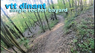
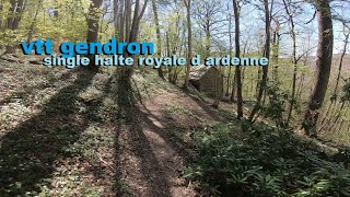
Popular Dinant Mountain Biking Trails
• 90 ★ 4.0 • 1 mile • 46 ft • 53 •
Popular blue difficulty mixed. This mountain bike primary trail can be used downhill primary and has a hard overall physical rating with a 46 ft black diamond climb. On average it takes 4 minutes to complete this trail.
• 5 ★ 3.0 • 2 miles • 554 ft • 48 •
Less popular green difficulty mixed. This mountain bike primary trail can be used uphill primary and has a hard overall physical rating with a 554 ft black diamond climb. On average it takes 15 minutes to complete this trail.
• 5 ★ 4.0 • 1 mile • 431 ft • 35 •
Less popular green difficulty singletrack. This mountain bike primary trail can be used uphill primary and has a hard overall physical rating with a 431 ft blue climb. On average it takes 9 minutes to complete this trail.
• 5 ★ 0.0 • 3,481 ft • 194 ft • 27 •
Less popular blue difficulty singletrack. This mountain bike primary trail can be used both directions and has a easy overall physical rating with a 194 ft green climb. On average it takes 5 minutes to complete this trail.
• ★ 0.0 • 538 ft • 0 ft • 24 •
Green difficulty doubletrack. This mountain bike primary trail can be used both directions. On average it takes 1 minutes to complete this trail.
• ★ 2.0 • 3,159 ft • 17 ft • 22 •
Fun downhill trail north of the Rue de . Some slightly technical parts with small rocks. Beware of trail runners.
• ★ 5.0 • 2 miles • 51 ft • 20 •
Blue difficulty singletrack. This mountain bike primary trail can be used both directions. On average it takes 14 minutes to complete this trail.
Dinant Mountain Bike Routes
Recent Trail Reports
| status | trail | date | condition | info | user |
|---|---|---|---|---|---|
| General Hodges Switchbacks | Mar 24, 2026 @ 10:34am (Europe/Brussels) Mar 24, 2026 | Ideal | quentin1 | ||
| GR 126 | Mar 24, 2026 @ 10:34am (Europe/Brussels) Mar 24, 2026 | Ideal | quentin1 | ||
| GR 125 | Mar 24, 2026 @ 10:34am (Europe/Brussels) Mar 24, 2026 | Ideal | quentin1 | ||
| GR 125 Climb | Oct 10, 2022 @ 6:14am Oct 10, 2022 | Unknown | DeAardappel |
Activity Feed
| username | action | type | title | date |
|---|---|---|---|---|
| mtbgreg1 | ridden | trail | activity #96928848 | Jun 13, 2026 @ 5:32pm Jun 13, 2026 |
| mtbgreg1 | add | trail | activity #96787467 | Jun 11, 2026 @ 11:53pm Jun 11, 2026 |
| Ronvdbrug | wishlist | region | activity #93466621 | Apr 26, 2026 @ 12:07pm Apr 26, 2026 |
| quentin1 | vote | trail | activity #91259140 and 8 more | Mar 25, 2026 @ 6:19am Mar 25, 2026 |
| quentin1 | add | report | activity #91247920 and 2 more | Mar 24, 2026 @ 11:20pm Mar 24, 2026 |
Recent Comments
| username | type | title | comment | date |
|---|---|---|---|---|
| trail | Moins dur que son voisin . | Jan 31, 2023 @ 1:17pm Jan 31, 2023 | ||
| trail | Tres pentu avec des marches et rocher ,c est... | Jan 31, 2023 @ 1:16pm Jan 31, 2023 | ||
| trail | Tres beau single avec quelque virage serrer... | Jan 31, 2023 @ 1:14pm Jan 31, 2023 | ||
| trail | Fun trail, but some parts very technical (you... | Oct 10, 2022 @ 6:17am Oct 10, 2022 | ||
| trail | Pretty hard climb. You probably have to go by... | Oct 10, 2022 @ 6:16am Oct 10, 2022 |
Local Badges
-

Epic Mountain Bike Climb 2k49 awarded -

Climbing 10k Badge8 awarded -

Mountain Biking 100k Badge0 awarded -

Epic Ride Descent 2k49 awarded -

Descent 10k Badge8 awarded -

Descent 100k Badge0 awarded
Activity Type Stats
| activitytype | trails | distance | descent | descent distance | total vertical | rating | global rank | state rank | photos | reports | routes | ridelogs |
|---|---|---|---|---|---|---|---|---|---|---|---|---|
| Mountain Bike | 40 | 20 miles | 4,088 ft | 10 miles | 607 ft | #3,387 | #26 | 1 | 4 | 3 | 1,373 | |
| E-Bike | 9 | 7 miles | 1,752 ft | 4 miles | 574 ft | #1,719 | #24 | 3 | 89 | |||
| Hike | 40 | 20 miles | 3,924 ft | 10 miles | 607 ft | #2,127 | #22 | 4 | 320 | |||
| Trail Running | 41 | 20 miles | 4,088 ft | 10 miles | 607 ft | #1,654 | #22 | 4 | 51 |
Frequently Asked Questions About Dinant
▼
What are the best places to ride in Dinant?
Dinant has 1 areas to explore for mountain biking. The top rated areas are:
▼
What are the highest rated mountain biking trails in Dinant?
The highest rated mountain biking trails in Dinant are:
- GR 126 (4.1/5)
- GR 125 (4.1/5)
- Gendron Sentier Royale D Ardenne (4.1/5)
- Froidvau (4.1/5)
- Bon-Air (4/5)
▼
What is the best time of the year to ride in Dinant?
Based on ride log data, the most popular months to ride in Dinant are:
- July (41 activities)
- September (6 activities)
- November (5 activities)
▼
Where can I park to ride in Dinant?
Check the Dinant trail map for trailhead and parking information. Community members regularly update access and parking details for trails in the area.
- By anonymus1 & contributors
- Admins: apply
- #21383 - 5,705 views
- dinant activity log | embed map of Dinant mountain bike trails |
Downloading of trail gps tracks in kml & gpx formats is enabled for Dinant.
You must login to download files.