close
-
Layers w
- Weather Layers
- Pro
- Pro
- Pro
- Pro
- Pro
- Pro
- More Layers
- Pro
- Pro
- Pro
- Pro
-
Upgrade to

3D
Trail Conditions
- Unknown
- Snow Groomed
- Snow Packed
- Snow Covered
- Snow Cover Partial
- Freeze/thaw Cycle
- Icy
- Prevalent Mud
- Wet
- Variable
- Ideal
- Dry
- Very Dry
Trail Flow (Ridden Direction)
Trailforks scans users ridelogs to determine the most popular direction each trail is ridden. A good flowing trail network will have most trails flowing in a single direction according to their intension.
The colour categories are based on what percentage of riders are riding a trail in its intended direction.
The colour categories are based on what percentage of riders are riding a trail in its intended direction.
- > 96%
- > 90%
- > 80%
- > 70%
- > 50%
- < 50%
- bi-directional trail
- no data
Trail Last Ridden
Trailforks scans ridelogs to determine the last time a trail was ridden.
- < 2 days
- < 1 week
- < 2 weeks
- < 1 month
- < 6 months
- > 6 months
Trail Ridden Direction
The intended direction a trail should be ridden.
- Downhill Only
- Downhill Primary
- Both Directions
- Uphill Primary
- Uphill Only
- One Direction
Contribute Details
Colors indicate trail is missing specified detail.
- Description
- Photos
- Description & Photos
- Videos
Trail Popularity ?
Trailforks scans ridelogs to determine which trails are ridden the most in the last 9 months.
Trails are compared with nearby trails in the same city region with a possible 25 colour shades.
Think of this as a heatmap, more rides = more kinetic energy = warmer colors.
- most popular
- popular
- less popular
- not popular
ATV/ORV/OHV Filter
Max Vehicle Width
inches
US Cell Coverage
Legend

Radar Time
Activity Recordings
Trailforks uses anonymized public activity data.
?
Activity Recordings
Trailforks uses anonymized public activity data.
?
Personal Heatmap
▶
Activity Types
all
/
none
▶
Options
2
Date range
month
–
Winter Trails
Warning
A routing network for winter maps does not exist. Selecting trails using the winter trails layer has been disabled.
Missing Trails
Most Popular
Least Popular
Trails are colored based on popularity. The more popular a trail is, the more red. Less popular trails trend towards green.
Jump Magnitude Heatmap
Heatmap of where riders jump on trails. Zoom in to see individual jumps, click circles to view jump details.
BC Backroad Status
![map legend]()
Service Road Atlas is a free to use, community-driven service for viewing and creating reports on the numerous back-country service roads around B.C. and Alberta.

Slope Aspect
Direction the slope faces
Trails Deemphasized
Trails are shown in grey.
Only show trails with no bike usage.
Suggested Layers
Based on selected activity type
Save the current map location and zoom level as your default home location whenever this page is loaded.
Save
No description for Dromana has been added yet!
Login or register to submit one.
Activities Click to view
- Mountain Bike
74 trails
- E-Bike
74 trails
- Adaptive Bike
1 trails
- Winter Fat Bike
1 trails
- Hike
30 trails
- Trail Running
30 trails
Region Details
- 1
Region Status
Caution as of Jun 16, 2026Stats
- Avg Trail Rating
- Trails (view details)
- 1
- Trails Mountain Bike
- 26
- Trails E-Bike
- 26
- Trails Adaptive Bike
- 1
- Trails Winter Fat Bike
- 1
- Trails Hike
- 1
- Trails Trail Running
- 1
- Reports
- 219
- Photos
- 218
- Ridden Counter
- 23,651
Sub Regions
-
Arthurs Seat State Park
- 1
-
Red Hill Mountain Bike Park
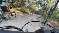
Popular Dromana Mountain Biking Trails
• 70 ★ 4.1 • 1 mile • 15 ft • 1,430 •
Trail 4 One way descending Natural surface single trail with minimal gradients and exposed tree roots
• 75 ★ 4.2 • 3,652 ft • 88 ft • 1,224 •
1.1km - Downhill Remodelled top section (early 2023) provides a more flow start before entering into some challenging drops and rock gardens, before becoming a flowing single trail that follows the natural contours of the landscape.
• 100 ★ 3.2 • 761 ft • 0 ft • 1,168 •
250m - Two Way A short blast, up or down, linking junction with the fire road that leads to and
• 45 ★ 4.3 • 3,110 ft • 6 ft • 1,056 •
It starts of with a rock drop in then straight over a rock garden. Further down there is some tight off chamber sections Going into some fast flowy trees then you go over some fast drops into a tight . Further down you shot up over a...
Dromana Mountain Bike Routes
15 miles • 996 ft • 0 •
Starting from the water tank trail head of Arthurs Seat MTB park, this route takes you along some of the...
9 miles • 1,734 ft • 14 • Race •
"A mountain bike event designed to be inclusive to all riders identifying as female, working to support...
5 miles • 1,002 ft • 1 • Race •
Australian National Gravity Enduro Championships Pro stage
9 miles • 1,560 ft • 3 • Race •
Australian National Adaptive Gravity Enduro Championships
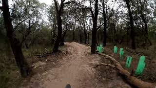
Photos of Dromana Mountain Bike
Videos of Dromana Mountain Bike
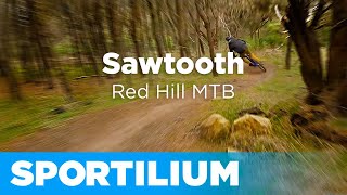
trail: Fall Line
3:08 |
|
Feb 23, 2023
youtuber
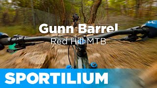
![Gunn Barrel #shorts #downhillmtb...]()
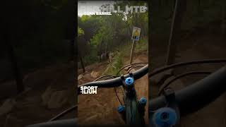
trail: Gunn Barrel
0:43 |
502 |
Sep 27, 2023 , Dromana
youtuber
![Crits into Glenn's Pony \\ Red Hill MTB]()
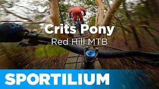
trail: Glenn’s Pony
5:19 |
433 |
Aug 15, 2023 , Dromana
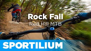

youtuber
![Gunn Barrel \\ Red Hill MTB]()
trail: Gunn Barrel
4:30 |
1025 |
Jul 18, 2023 , Dromana
Current Trail Warnings
| status | trail | date | condition | user | info |
|---|---|---|---|---|---|
| Crits | Jun 17, 2026 @ 12:01pm (Australia/Melbourne) Jun 16, 2026 | Wet | Horaldo | tree down needs chainsaw | |
| Gunn Barrel | Jun 5, 2026 @ 10:16am (Australia/Melbourne) Jun 4, 2026 | Unknown | jazzaphil | Tree down before final gap jump at... |
Recent Trail Reports
| status | trail | date | condition | info | user |
|---|---|---|---|---|---|
| Fall Line | Jun 14, 2026 @ 10:08am (Australia/Melbourne) Jun 13, 2026 | Wet | gunny27 RedHill | ||
| Sawtooth | Jun 2, 2026 @ 2:58pm (Australia/Melbourne) Jun 1, 2026 | Unknown | Kookonabike | ||
| Link | May 10, 2026 @ 8:54am (Australia/Melbourne) May 9, 2026 | Unknown | clubbeno | ||
| High Roller | Mar 11, 2026 @ 2:01pm (Australia/Melbourne) Mar 10, 2026 | Dry | jimmyfmx | ||
| Crusher | Jan 31, 2026 @ 3:23pm (Australia/Melbourne) Jan 30, 2026 | Unknown | Kdiamond78 | ||
| Charlottes Pass | Jan 19, 2026 @ 8:36pm (Australia/Melbourne) Jan 19, 2026 | Unknown | gunny27 RedHill | ||
| Wombat | Jan 16, 2026 @ 8:02pm (Australia/Melbourne) Jan 16, 2026 | Dry | ZjPYGT | ||
| Glenn’s Pony | Jan 16, 2026 @ 7:50pm (Australia/Melbourne) Jan 16, 2026 | Dry | jimmyfmx | ||
| Pins and Needles | Jan 9, 2026 @ 8:49am (Australia/Melbourne) Jan 8, 2026 | Ideal | jimmyfmx | ||
| Deadwoods | Jan 4, 2026 @ 1:02pm (Australia/Melbourne) Jan 3, 2026 | Very Dry | jimmyfmx |
Activity Feed
| username | action | type | title | date |
|---|---|---|---|---|
| Horaldo | add | report | activity #97155622 | Jun 16, 2026 @ 7:01pm Jun 16, 2026 |
| gunny27 | add | report | activity #96927464 | Jun 13, 2026 @ 5:08pm Jun 13, 2026 |
| jazzaphil | add | report | activity #96263249 | Jun 4, 2026 @ 5:16pm Jun 4, 2026 |
| Kookonabike | add | report | activity #96062476 | Jun 1, 2026 @ 9:58pm Jun 1, 2026 |
| JessicaQXJUK6 | add | report | activity #95305538 | May 23, 2026 @ 4:51am May 23, 2026 |
Recent Comments
| username | type | title | comment | date |
|---|---|---|---|---|
| trail | Tree down just after fire road crossing | May 13, 2026 @ 3:54pm May 13, 2026 | ||
| report | Fixed now | May 11, 2026 @ 4:53pm May 11, 2026 | ||
| trail | top section way to hard i reacen | Mar 17, 2026 @ 4:20am Mar 17, 2026 | ||
| trail | track is great but the high corners with a... | Mar 17, 2026 @ 4:19am Mar 17, 2026 | ||
| trail | This was the hardest Intermediate (blue) track... | Feb 21, 2026 @ 8:55pm Feb 21, 2026 |
Local Badges
-

Epic Ride Climb 2k92 awarded -

Climbing 10k Badge153 awarded -

Climbing 100k Badge10 awarded -

Epic Ride Descent 2k108 awarded -

Descent 10k Badge159 awarded -

Descent 100k Badge11 awarded
Bike & Skill Parks
| name | type | city | rating |
|---|---|---|---|
| Red Hill Skills Track | skill park | Dromana |
Local Trail Supporters
- Mornington Tint-a-Car
- The Bicycle Company
- [Available - contact RHR]
- Healthwise Therapies
- Formula Racing
- Bendigo Bank - Rosebud
- Peninsula Quarries
- Six Point Eight Cycles
![]()
- Mornington Cycles
- Chain Brain
- Specialized
![]()
Activity Type Stats
| activitytype | trails | distance | descent | descent distance | total vertical | rating | global rank | state rank | photos | reports | routes | ridelogs |
|---|---|---|---|---|---|---|---|---|---|---|---|---|
| Mountain Bike | 74 | 35 miles | 6,795 ft | 18 miles | 804 ft | #988 | #55 | 359 | 802 | 9 | 27,063 | |
| E-Bike | 74 | 28 miles | 6,099 ft | 15 miles | 804 ft | #1,756 | #94 | 2 | 679 | 1 | 3,625 | |
| Adaptive Bike | 1 | #167 | #137 | 1 | ||||||||
| Winter Fat Bike | 1 | #118 | #74 | |||||||||
| Hike | 30 | 26 miles | 3,100 ft | 14 miles | 892 ft | #4,928 | #151 | 543 | 452 | |||
| Trail Running | 30 | 26 miles | 3,100 ft | 14 miles | 892 ft | #4,351 | #130 | 543 | 4 | 265 |
- By canadaka
 Trailforks & contributors
 - Admins: Victoria, RedHill
- #8097 - 13,487 views
- dromana activity log | embed map of Dromana mountain bike trails | dromana mountain biking points of interest
Downloading of trail gps tracks in kml & gpx formats is enabled for Dromana.
You must login to download files.