close
-
Layers w
- Weather Layers
- Pro
- Pro
- Pro
- Pro
- Pro
- Pro
- More Layers
- Pro
- Pro
- Pro
- Pro
-
Upgrade to

3D
Trail Conditions
- Unknown
- Snow Groomed
- Snow Packed
- Snow Covered
- Snow Cover Partial
- Freeze/thaw Cycle
- Icy
- Prevalent Mud
- Wet
- Variable
- Ideal
- Dry
- Very Dry
Trail Flow (Ridden Direction)
Trailforks scans users ridelogs to determine the most popular direction each trail is ridden. A good flowing trail network will have most trails flowing in a single direction according to their intension.
The colour categories are based on what percentage of riders are riding a trail in its intended direction.
The colour categories are based on what percentage of riders are riding a trail in its intended direction.
- > 96%
- > 90%
- > 80%
- > 70%
- > 50%
- < 50%
- bi-directional trail
- no data
Trail Last Ridden
Trailforks scans ridelogs to determine the last time a trail was ridden.
- < 2 days
- < 1 week
- < 2 weeks
- < 1 month
- < 6 months
- > 6 months
Trail Ridden Direction
The intended direction a trail should be ridden.
- Downhill Only
- Downhill Primary
- Both Directions
- Uphill Primary
- Uphill Only
- One Direction
Contribute Details
Colors indicate trail is missing specified detail.
- Description
- Photos
- Description & Photos
- Videos
Trail Popularity ?
Trailforks scans ridelogs to determine which trails are ridden the most in the last 9 months.
Trails are compared with nearby trails in the same city region with a possible 25 colour shades.
Think of this as a heatmap, more rides = more kinetic energy = warmer colors.
- most popular
- popular
- less popular
- not popular
ATV/ORV/OHV Filter
Max Vehicle Width
inches
US Cell Coverage
Legend

Radar Time
Activity Recordings
Trailforks uses anonymized public activity data.
?
Activity Recordings
Trailforks uses anonymized public activity data.
?
Personal Heatmap
▶
Activity Types
all
/
none
▶
Options
2
Date range
month
–
Winter Trails
Warning
A routing network for winter maps does not exist. Selecting trails using the winter trails layer has been disabled.
Missing Trails
Most Popular
Least Popular
Trails are colored based on popularity. The more popular a trail is, the more red. Less popular trails trend towards green.
Jump Magnitude Heatmap
Heatmap of where riders jump on trails. Zoom in to see individual jumps, click circles to view jump details.
BC Backroad Status
![map legend]()
Service Road Atlas is a free to use, community-driven service for viewing and creating reports on the numerous back-country service roads around B.C. and Alberta.

Slope Aspect
Direction the slope faces
Trails Deemphasized
Trails are shown in grey.
Only show trails with no bike usage.
Suggested Layers
Based on selected activity type
Save the current map location and zoom level as your default home location whenever this page is loaded.
Save
No description for Drumnadrochit has been added yet!
Login or register to submit one.
This region uses the Uk/Euro style trail grading system.
Activities Click to view
- Mountain Bike
60 trails
- E-Bike
51 trails
- Adaptive Bike
0 trails
- Horse
7 trails
- Hike
40 trails
- Trail Running
40 trails
Region Details
- 14
- 14
- 11
- 7
- 12
Region Status
Caution as of May 20, 2026Stats
- Avg Trail Rating
- Trails (view details)
- 58
- Trails Mountain Bike
- 60
- Trails E-Bike
- 51
- Trails Horse
- 7
- Trails Hike
- 40
- Trails Trail Running
- 40
- Total Distance
- 35 miles
- Total Descent
- 6,885 ft
- Total Vertical
- 1,247 ft
- Highest Trailhead
- 1,403 ft
- Reports
- 108
- Photos
- 29
- Ridden Counter
- 3,285
Sub Regions
-
Abriachan Kelpies
- 10
- 11
- 3
-
Cnoc A' Bhuachaille
- 4
- 4
- 12
Popular Drumnadrochit Mountain Biking Trails
• 100 ★ 0.0 • 525 ft • 11 ft • 165 •
Popular green difficulty singletrack. This mountain bike primary trail can be used both directions. On average it takes 2 minutes to complete this trail.
• 90 ★ 2.0 • 2,871 ft • 124 ft • 134 •
Popular blue difficulty singletrack. This mountain bike primary trail can be used uphill only. On average it takes 10 minutes to complete this trail.
• 85 ★ 0.0 • 1,014 ft • 19 ft • 128 •
Popular blue difficulty singletrack. This mountain bike primary trail can be used uphill only. On average it takes 3 minutes to complete this trail.
• 85 ★ 3.0 • 3,087 ft • 13 ft • 128 •
Popular blue difficulty singletrack. This mountain bike primary trail can be used downhill primary. On average it takes 3 minutes to complete this trail.
• 90 ★ 3.0 • 2,359 ft • 5 ft • 128 •
Popular blue difficulty family friendly singletrack. This mountain bike primary trail can be used downhill primary. On average it takes 2 minutes to complete this trail.
• 95 ★ 3.0 • 1,654 ft • 76 ft • 127 •
Popular blue difficulty singletrack. This mountain bike primary trail can be used uphill only. On average it takes 3 minutes to complete this trail.
• 90 ★ 3.0 • 1,165 ft • 0 ft • 126 •
Popular blue difficulty singletrack. This mountain bike primary trail can be used downhill primary. On average it takes minutes to complete this trail.
• 100 ★ 3.0 • 1,440 ft • 88 ft • 125 •
Popular blue difficulty family friendly singletrack. This mountain bike primary trail can be used downhill primary. On average it takes 3 minutes to complete this trail.
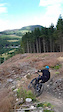
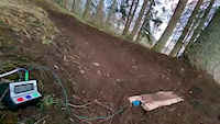
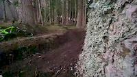
Photos of Drumnadrochit Mountain Bike
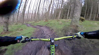
Videos of Drumnadrochit Mountain Bike
trail: Berm Palace
0:08 |
186 |
Jul 20, 2020
trail: Berm Palace
0:22 |
238 |
Feb 14, 2020
trail: Berm Palace
0:20 |
131 |
Feb 14, 2020
trail: Green
3:09 |
142 |
Mar 14, 2017
trail: Green
2:34 |
79 |
Sep 19, 2016

trail: Green
4:16 |
150 |
May 16, 2016

trail: Green
3:00 |
309 |
Jul 8, 2014

trail: Green
0:52 |
188 |
Mar 8, 2014
Recent Trail Reports
| status | trail | date | condition | info | user |
|---|---|---|---|---|---|
| The Real Racoon Run | May 20, 2026 @ 4:09pm (Europe/London) May 20, 2026 | Unknown | chrissampson2 | ||
| Racoon Run | May 20, 2026 @ 4:07pm (Europe/London) May 20, 2026 | Unknown | chrissampson2 | ||
| Access | May 4, 2026 @ 7:59pm (Europe/London) May 4, 2026 | Very Dry | Rogeroo | ||
| Apex | Mar 12, 2026 @ 8:13am (Europe/London) Mar 12, 2026 | Unknown | ronantaylor | ||
| Bull Run | Mar 12, 2026 @ 8:12am (Europe/London) Mar 12, 2026 | Unknown | ronantaylor | ||
| Red | Mar 12, 2026 @ 8:10am (Europe/London) Mar 12, 2026 | Unknown | ronantaylor | ||
| Red (upper) | Feb 23, 2026 @ 7:57am (Europe/London) Feb 22, 2026 | Wet | trailco-ordinator BSTA | ||
| Link | Jan 31, 2026 @ 6:24pm (Europe/London) Jan 31, 2026 | Unknown | ronantaylor | ||
| Link | Jan 31, 2026 @ 6:08pm (Europe/London) Jan 31, 2026 | Unknown | ronantaylor | ||
| Lockdown | Jan 31, 2026 @ 6:04pm (Europe/London) Jan 31, 2026 | Unknown | ronantaylor |
Activity Feed
| username | action | type | title | date |
|---|---|---|---|---|
| AoifeNet | ridden | trail | activity #96658458 | Jun 10, 2026 @ 1:04am Jun 10, 2026 |
| chrissampson2 | add | report | activity #95108661 and 1 more | May 20, 2026 @ 8:07am May 20, 2026 |
| Rogeroo | add | report | activity #94039537 and 1 more | May 4, 2026 @ 11:56am May 4, 2026 |
| Rogeroo | vote | trail | activity #94039341 and 7 more | May 4, 2026 @ 11:52am May 4, 2026 |
| Rogeroo | ridden | trail | activity #94039337 and 7 more | May 4, 2026 @ 11:52am May 4, 2026 |
Recent Comments
| username | type | title | comment | date |
|---|---|---|---|---|
| trail | Top section mega overgrown. Second part after... | Jul 26, 2024 @ 9:13am Jul 26, 2024 | ||
| trail | Not there anymore after tree felling? | Oct 22, 2023 @ 2:16pm Oct 22, 2023 | ||
| trail | Completely overgrown and destroyed by... | May 17, 2023 @ 5:51am May 17, 2023 | ||
| trail | Aw | May 10, 2023 @ 2:34pm May 10, 2023 | ||
| trail | Overgrown and not maintained. An amazing trail... | Sep 18, 2022 @ 6:07am Sep 18, 2022 |
Local Badges
-

Epic Ride Climb 2k54 awarded -

Climbing 10k Badge9 awarded -

Climbing 100k Badge0 awarded -

Epic Ride Descent 2k48 awarded -

Descent 10k Badge9 awarded -

Descent 100k Badge0 awarded
Activity Type Stats
| activitytype | trails | distance | descent | descent distance | total vertical | rating | global rank | state rank | photos | reports | routes | ridelogs |
|---|---|---|---|---|---|---|---|---|---|---|---|---|
| Mountain Bike | 60 | 35 miles | 6,886 ft | 15 miles | 1,247 ft | #4,238 | #134 | 29 | 108 | 1,543 | ||
| E-Bike | 51 | 27 miles | 4,245 ft | 11 miles | 1,247 ft | #3,415 | #123 | 89 | 130 | |||
| Horse | 7 | 6 miles | 266 ft | 1 mile | 928 ft | #1,684 | #89 | 2 | ||||
| Hike | 40 | 27 miles | 3,720 ft | 10 miles | 1,247 ft | #5,334 | #123 | 83 | 164 | |||
| Trail Running | 40 | 27 miles | 3,720 ft | 10 miles | 1,247 ft | #5,267 | #125 | 83 | 124 |
Frequently Asked Questions About Drumnadrochit
▼
What are the best places to ride in Drumnadrochit?
Drumnadrochit has 2 areas to explore for mountain biking. The top rated areas are:
▼
What are the highest rated mountain biking trails in Drumnadrochit?
The highest rated mountain biking trails in Drumnadrochit are:
- String Theory (4.2/5)
- Ribbon (4.1/5)
- Red (upper) (4.1/5)
- The Darkness (Upper) (4.1/5)
- McRibbon (4/5)
▼
What is the best time of the year to ride in Drumnadrochit?
Based on ride log data, the most popular months to ride in Drumnadrochit are:
- September (3 activities)
- February (3 activities)
- January (3 activities)
▼
Where can I park to ride in Drumnadrochit?
There are 3 parking locations listed in Drumnadrochit. The most popular parking spots are: View all parking and trailhead locations on the map to plan your visit.
Activities
Trails
Points of Interest
- By londondl
 & contributors
 - Admins: DMBinS, FLS, LTA
- #17749 - 5,134 views
- drumnadrochit activity log | embed map of Drumnadrochit mountain bike trails | drumnadrochit mountain biking points of interest polygons
Downloading of trail gps tracks in kml & gpx formats is enabled for Drumnadrochit.
You must login to download files.