close
-
Layers w
- Weather Layers
- Pro
- Pro
- Pro
- Pro
- Pro
- Pro
- More Layers
- Pro
- Pro
- Pro
- Pro
-
Upgrade to

3D
Trail Conditions
- Unknown
- Snow Groomed
- Snow Packed
- Snow Covered
- Snow Cover Partial
- Freeze/thaw Cycle
- Icy
- Prevalent Mud
- Wet
- Variable
- Ideal
- Dry
- Very Dry
Trail Flow (Ridden Direction)
Trailforks scans users ridelogs to determine the most popular direction each trail is ridden. A good flowing trail network will have most trails flowing in a single direction according to their intension.
The colour categories are based on what percentage of riders are riding a trail in its intended direction.
The colour categories are based on what percentage of riders are riding a trail in its intended direction.
- > 96%
- > 90%
- > 80%
- > 70%
- > 50%
- < 50%
- bi-directional trail
- no data
Trail Last Ridden
Trailforks scans ridelogs to determine the last time a trail was ridden.
- < 2 days
- < 1 week
- < 2 weeks
- < 1 month
- < 6 months
- > 6 months
Trail Ridden Direction
The intended direction a trail should be ridden.
- Downhill Only
- Downhill Primary
- Both Directions
- Uphill Primary
- Uphill Only
- One Direction
Contribute Details
Colors indicate trail is missing specified detail.
- Description
- Photos
- Description & Photos
- Videos
Trail Popularity ?
Trailforks scans ridelogs to determine which trails are ridden the most in the last 9 months.
Trails are compared with nearby trails in the same city region with a possible 25 colour shades.
Think of this as a heatmap, more rides = more kinetic energy = warmer colors.
- most popular
- popular
- less popular
- not popular
ATV/ORV/OHV Filter
Max Vehicle Width
inches
US Cell Coverage
Legend

Radar Time
Activity Recordings
Trailforks uses anonymized public activity data.
?
Activity Recordings
Trailforks uses anonymized public activity data.
?
Personal Heatmap
▶
Activity Types
all
/
none
▶
Options
2
Date range
month
–
Winter Trails
Warning
A routing network for winter maps does not exist. Selecting trails using the winter trails layer has been disabled.
Missing Trails
Most Popular
Least Popular
Trails are colored based on popularity. The more popular a trail is, the more red. Less popular trails trend towards green.
Jump Magnitude Heatmap
Heatmap of where riders jump on trails. Zoom in to see individual jumps, click circles to view jump details.
BC Backroad Status
![map legend]()
Service Road Atlas is a free to use, community-driven service for viewing and creating reports on the numerous back-country service roads around B.C. and Alberta.

Slope Aspect
Direction the slope faces
Trails Deemphasized
Trails are shown in grey.
Only show trails with no bike usage.
Suggested Layers
Based on selected activity type
Save the current map location and zoom level as your default home location whenever this page is loaded.
SaveActivities Click to view
- Mountain Bike
52 trails
- E-Bike
48 trails
- Gravel Bike
3 trails
- Adaptive Bike
0 trails
- Hike
80 trails
- Trail Running
80 trails
- Snowshoe
7 trails
- Downhill Ski
20 trails
- Nordic Ski
12 trails
Region Details
- 4
- 1
- 11
- 25
- 8
- 3
Region Status
Caution as of 10 hoursStats
- Avg Trail Rating
- Trails (view details)
- 104
- Trails Mountain Bike
- 52
- Trails E-Bike
- 48
- Trails Gravel Bike
- 3
- Trails Hike
- 80
- Trails Trail Running
- 80
- Trails Snowmobile
- 1
- Trails Snowshoe
- 7
- Trails Downhill Ski
- 20
- Trails Backcountry Ski
- 1
- Trails Nordic Ski
- 12
- Total Distance
- 76 miles
- Total Descent
- 7,200 ft
- Total Vertical
- 550 ft
- Highest Trailhead
- 1,146 ft
- Reports
- 16,511
- Photos
- 101
- Ridden Counter
- 7,255
Sub Regions
-
Cloie Creek
- 3
- 2
-
FDR Mountain Bike Park
- 2
- 14
- 4
-
Heritage Trail
- 1
-
Interstate Power Preserve (IPP)
- 2
- 2
- 1
-
Proving Grounds
- 6
- 7
- 2
- 2
Popular Dubuque Mountain Biking Trails
• 90 ★ 4.7 • 1 mile • 156 ft • 227 •
Highly rated popular blue difficulty singletrack. This multi-use trail can be used both directions. On average it takes 9 minutes to complete this trail.
• 75 ★ 4.9 • 1 mile • 175 ft • 218 •
offers additional beginner friendly trail with a narrower feel and various rock jumps and features available. Ride it both ways for maximum enjoyment.
• 65 ★ 3.0 • 2,254 ft • 16 ft • 217 •
Moderately popular green difficulty wilderness trail. This multi-use trail can be used both directions and has a easy overall physical rating with a 16 ft green climb. Trail visibility is always easy to follow. On average it takes 5 minutes to complete this trail.
• 70 ★ 4.6 • 2,100 ft • 3 ft • 215 •
Popular black diamond difficulty singletrack. This mountain bike primary trail can be used one direction. It features berm, drop and jump. On average it takes 3 minutes to complete this trail.
• 85 ★ 3.0 • 453 ft • 0 ft • 212 •
Popular green difficulty wilderness trail. This multi-use trail can be used both directions. On average it takes minutes to complete this trail.
Dubuque Mountain Bike Routes
★ 5.0 • 8 miles • 857 ft • 23 •
Good way to run all the fun and gnarly parts of Proving Grounds
★ 4.0 • 9 miles • 959 ft • 17 •
Get the full mileage out of FDR with this route. No repeats.
5 miles • 479 ft • 12 •
Proposed option for routing race without SRW or D&C
6 miles • 669 ft • 17 •
Proposal for IMBCS Race. Route does not cross over itself
12 miles • 1,157 ft • 23 •
12.5 miles covering all the trails but , and some trails twice
Photos of Dubuque Mountain Bike
Videos of Dubuque Mountain Bike
youtuber
![First time riding at Farside Bike Park! ||...]()

18:55 |
76 |
Jul 9, 2025
youtuber
![Interstate Power Preserve | Dubuque, Iowa]()
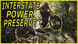
10:59 |
140 |
Apr 7, 2024
youtuber
![Proving Grounds | Dubuque, Iowa]()

9:22 |
214 |
Mar 31, 2024
youtuber
![Proving Grounds | Dubuque, Iowa]()
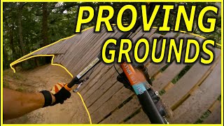
9:22 |
152 |
Mar 31, 2024
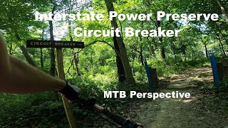
trail: Circuit Breaker
6:33 |
241 |
Jul 26, 2023 , Dubuque
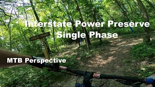
trail: Single Phase
8:10 |
138 |
Jul 26, 2023 , Dubuque
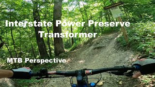
trail: Transformer
5:52 |
259 |
Jul 26, 2023 , Dubuque
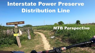
trail: Distribution Line
17:01 |
225 |
Jul 26, 2023 , Dubuque
Recent Trail Reports
Activity Feed
| username | action | type | title | date |
|---|---|---|---|---|
| chipkm | add | report | activity #97724876 and 18 more | Jun 24, 2026 @ 2:38pm 10 hours |
| adamjacobson | add | report | activity #97671609 and 5 more | Jun 23, 2026 @ 8:11pm 1 day |
| berrthum | add | report | activity #97635284 and 6 more | Jun 23, 2026 @ 10:06am 2 days |
| chipkm | add | report | activity #97599885 and 18 more | Jun 22, 2026 @ 7:29pm 2 days |
| chipkm | add | report | activity #97558092 | Jun 22, 2026 @ 6:43am 3 days |
Recent Comments
| username | type | title | comment | date |
|---|---|---|---|---|
| report | Tree down on berm a few turns before short... | Jul 16, 2023 @ 10:50am Jul 16, 2023 | ||
| report | Tree down at berm before climb out begins | Jul 16, 2023 @ 10:47am Jul 16, 2023 | ||
| report | Riding well | Jul 12, 2023 @ 7:44am Jul 12, 2023 | ||
| trail | Now this is a trail! Sessioned this trail to... | Jun 20, 2023 @ 11:49am Jun 20, 2023 | ||
| report | Parking lot closed / under construction | May 18, 2023 @ 11:40am May 18, 2023 |
Local Badges
-

10 Blue Trails127 awarded -

Epic Ride Climb 2k12 awarded -

Climbing 10k Badge28 awarded -

Climbing 100k Badge8 awarded -

Epic Ride Descent 2k14 awarded -

Descent 10k Badge29 awarded
Bike & Skill Parks
| name | type | city | rating |
|---|---|---|---|
| Daniel's Den | skill park | Dubuque |
Activity Type Stats
| activitytype | trails | distance | descent | descent distance | total vertical | rating | global rank | state rank | photos | reports | routes | ridelogs |
|---|---|---|---|---|---|---|---|---|---|---|---|---|
| Mountain Bike | 52 | 52 miles | 3,461 ft | 16 miles | 472 ft | #1,167 | #449 | 100 | 16,511 | 7 | 10,345 | |
| E-Bike | 48 | 51 miles | 3,412 ft | 16 miles | 472 ft | #2,860 | #1,089 | 10,272 | 1 | 199 | ||
| Gravel Bike | 3 | 2 miles | 226 ft | 3,156 ft | 115 ft | #532 | #1,087 | 45 | 111 | |||
| Hike | 80 | 72 miles | 5,709 ft | 24 miles | 505 ft | #2,731 | #1,039 | 16,490 | 900 | |||
| Trail Running | 80 | 72 miles | 5,709 ft | 24 miles | 505 ft | #2,925 | #847 | 1 | 16,490 | 294 | ||
| Snowmobile | 1 | 25 miles | 161 ft | 6 miles | 472 ft | 1 | ||||||
| Snowshoe | 7 | 3 miles | 318 ft | 1 mile | 423 ft | #1,190 | #627 | 10,207 | 57 | |||
| Downhill Ski | 20 | 2 miles | 1,129 ft | 2 miles | 400 ft | #534 | #233 | 303 | ||||
| Backcountry Ski | 1 | 25 miles | 161 ft | 6 miles | 472 ft | 1 | 2 | |||||
| Nordic Ski | 12 | 5 miles | 358 ft | 2 miles | 194 ft | #1,218 | #541 | 10,207 | 11 |
Frequently Asked Questions About Dubuque
▼
What are the best places to ride in Dubuque?
Dubuque has 8 areas to explore for mountain biking. The top rated areas are:
▼
What are the highest rated mountain biking trails in Dubuque?
The highest rated mountain biking trails in Dubuque are:
- Single Phase (4.6/5)
- Transformer (4.5/5)
- Distribution Line (4.4/5)
- Circuit Breaker (4.4/5)
- Hot Start (4.4/5)
▼
What is the best time of the year to ride in Dubuque?
Based on ride log data, the most popular months to ride in Dubuque are:
- July (88 activities)
- August (60 activities)
- September (57 activities)
▼
Where can I park to ride in Dubuque?
There are 19 parking locations listed in Dubuque. The most popular parking spots are: View all parking and trailhead locations on the map to plan your visit.
Activities
Trails
- By brenthillier
 NSMBA TRAILFORKS & contributors
 - Admins: TMBR Monitor, TMBR
- #4703 - 10,989 views
- dubuque activity log | embed map of Dubuque mountain bike trails | dubuque mountain biking points of interest
Downloading of trail gps tracks in kml & gpx formats is enabled for Dubuque.
You must login to download files.