close
-
Layers w
- Weather Layers
- Pro
- Pro
- Pro
- Pro
- Pro
- Pro
- More Layers
- Pro
- Pro
- Pro
- Pro
-
Upgrade to

3D
Trail Conditions
- Unknown
- Snow Groomed
- Snow Packed
- Snow Covered
- Snow Cover Partial
- Freeze/thaw Cycle
- Icy
- Prevalent Mud
- Wet
- Variable
- Ideal
- Dry
- Very Dry
Trail Flow (Ridden Direction)
Trailforks scans users ridelogs to determine the most popular direction each trail is ridden. A good flowing trail network will have most trails flowing in a single direction according to their intension.
The colour categories are based on what percentage of riders are riding a trail in its intended direction.
The colour categories are based on what percentage of riders are riding a trail in its intended direction.
- > 96%
- > 90%
- > 80%
- > 70%
- > 50%
- < 50%
- bi-directional trail
- no data
Trail Last Ridden
Trailforks scans ridelogs to determine the last time a trail was ridden.
- < 2 days
- < 1 week
- < 2 weeks
- < 1 month
- < 6 months
- > 6 months
Trail Ridden Direction
The intended direction a trail should be ridden.
- Downhill Only
- Downhill Primary
- Both Directions
- Uphill Primary
- Uphill Only
- One Direction
Contribute Details
Colors indicate trail is missing specified detail.
- Description
- Photos
- Description & Photos
- Videos
Trail Popularity ?
Trailforks scans ridelogs to determine which trails are ridden the most in the last 9 months.
Trails are compared with nearby trails in the same city region with a possible 25 colour shades.
Think of this as a heatmap, more rides = more kinetic energy = warmer colors.
- most popular
- popular
- less popular
- not popular
ATV/ORV/OHV Filter
Max Vehicle Width
inches
US Cell Coverage
Legend

Radar Time
Activity Recordings
Trailforks uses anonymized public activity data.
?
Activity Recordings
Trailforks uses anonymized public activity data.
?
Personal Heatmap
▶
Activity Types
all
/
none
▶
Options
2
Date range
month
–
Winter Trails
Warning
A routing network for winter maps does not exist. Selecting trails using the winter trails layer has been disabled.
Missing Trails
Most Popular
Least Popular
Trails are colored based on popularity. The more popular a trail is, the more red. Less popular trails trend towards green.
Jump Magnitude Heatmap
Heatmap of where riders jump on trails. Zoom in to see individual jumps, click circles to view jump details.
BC Backroad Status
![map legend]()
Service Road Atlas is a free to use, community-driven service for viewing and creating reports on the numerous back-country service roads around B.C. and Alberta.

Slope Aspect
Direction the slope faces
Trails Deemphasized
Trails are shown in grey.
Only show trails with no bike usage.
Suggested Layers
Based on selected activity type
Save the current map location and zoom level as your default home location whenever this page is loaded.
Save
No description for Dundee has been added yet!
Login or register to submit one.
This region uses the Uk/Euro style trail grading system.
Activities Click to view
- Mountain Bike
28 trails
- E-Bike
16 trails
- Adaptive Bike
0 trails
- Hike
24 trails
- Trail Running
23 trails
Region Details
- 2
- 7
- 13
- 6
Region Status
Open as of Oct 6, 2025Stats
- Avg Trail Rating
- Trails (view details)
- 28
- Trails Mountain Bike
- 28
- Trails E-Bike
- 16
- Trails Hike
- 24
- Trails Trail Running
- 23
- Total Distance
- 11 miles
- Total Descent
- 1,763 ft
- Total Vertical
- 1,257 ft
- Highest Trailhead
- 1,347 ft
- Reports
- 49
- Photos
- 28
- Ridden Counter
- 1,096
Articles
Video: Wild Riding in the Slop at the Scottish Universities Biking Social in Dundee
Mar 5, 2020 from pinkbike.com
The second annual Scottish Universities Biking Social was last weekend in Dundee.
Sub Regions
-
Ballkello Woods
- 5
- 1
- 4
-
Dronley Community Woodland
- 2
- 7
-
Templeton Woods
- 4
- 2
Popular Dundee Mountain Biking Trails
• 100 ★ 5.0 • 2,480 ft • 35 ft • 144 •
1.2km Skills Trail feature Red and Blue options.
• 75 ★ 4.0 • 3,437 ft • 0 ft • 77 •
Popular red difficulty singletrack. This multi-use trail can be used downhill primary. It features berm, drop, jump and rock garden. On average it takes 13 minutes to complete this trail.
• 80 ★ 0.0 • 1,510 ft • 4 ft • 47 •
Popular red difficulty singletrack. This multi-use trail can be used downhill primary. It features rock garden. On average it takes 2 minutes to complete this trail.
• 95 ★ 3.5 • 2,470 ft • 0 ft • 44 • • hike
Follows edge of wood from Water Tower to South Auchray farm track. Mainly natural with a couple of drops and a balance beam to cross the ditch at the end. Rooty.
• 65 ★ 2.0 • 1,827 ft • 8 ft • 44 •
Moderately popular red difficulty singletrack. This multi-use trail can be used downhill primary. On average it takes 2 minutes to complete this trail.
• 100 ★ 0.0 • 384 ft • 0 ft • 44 •
Popular red difficulty singletrack. This mountain bike primary trail can be used one direction. On average it takes minutes to complete this trail.
• 60 ★ 0.0 • 2,165 ft • 274 ft • 38 •
Moderately popular green difficulty family friendly singletrack. This multi-use trail can be used both directions. Trail visibility is always easy to follow. On average it takes 8 minutes to complete this trail.
• 85 ★ 0.0 • 1,198 ft • 0 ft • 37 • • hike
Established natural single-track, with 2 rollable log jumps. Rooty and narrow between trees. Trail follows the northern edge of Templeton Woods from the water tower towards Clatto Park.
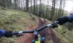
Photos of Dundee Mountain Bike
Videos of Dundee Mountain Bike

trail: Templeton Tangle
0:57 |
1258 |
Jul 31, 2018 , Dundee

trail: Templeton Tangle
1352 |
Apr 28, 2015 , Dundee

trail: Templeton Tangle
1128 |
Apr 28, 2015 , Dundee
Recent Trail Reports
| status | trail | date | condition | info | user |
|---|---|---|---|---|---|
| Shreddy Mercury | Jun 7, 2025 @ 8:05am Jun 7, 2025 | Dry | Knackered-Knee | ||
| Templeton Tangle | May 9, 2025 @ 2:51am May 9, 2025 | Dry | Knackered-Knee | ||
| Poachers Path | Mar 12, 2025 @ 9:08am Mar 12, 2025 | Ideal | Knackered-Knee | ||
| Root 66 | Mar 1, 2025 @ 9:23am Mar 1, 2025 | Ideal | Knackered-Knee | ||
| Access Road | Feb 25, 2025 @ 5:51am Feb 25, 2025 | Ideal | Knackered-Knee | ||
| Bob Gnarly | Jan 29, 2025 @ 4:37am Jan 29, 2025 | Unknown | Knackered-Knee | ||
| Cattlegrid | Jan 29, 2025 @ 4:31am Jan 29, 2025 | Unknown | Knackered-Knee | ||
| President Bush | Jan 29, 2025 @ 4:26am Jan 29, 2025 | Unknown | Knackered-Knee | ||
| East Poachers | Jan 27, 2025 @ 1:50am Jan 27, 2025 | Ideal | Knackered-Knee | ||
| Red Line | Jan 19, 2025 @ 3:05pm Jan 19, 2025 | Variable | SonOfaButcher |
Activity Feed
| username | action | type | title | date |
|---|---|---|---|---|
| EuyJY3 | vote | trail | activity #94760619 | May 15, 2026 @ 11:54am May 15, 2026 |
| Sean8sxjsO | ridden | trail | activity #83865840 and 1 more | Nov 9, 2025 @ 9:57am Nov 9, 2025 |
| Legiships | wishlist | region | activity #82056639 | Oct 10, 2025 @ 5:03am Oct 10, 2025 |
| Legiships | vote | trail | activity #82056615 | Oct 10, 2025 @ 5:02am Oct 10, 2025 |
| Callumbikes99 | wishlist | trail | activity #81171664 | Sep 26, 2025 @ 8:05pm Sep 26, 2025 |
Recent Comments
| username | type | title | comment | date |
|---|---|---|---|---|
| trail | It's a very good tarck for beginner to... | May 21, 2023 @ 5:57am May 21, 2023 | ||
| trail | Extremely overgrown might run better in winter | Sep 2, 2022 @ 12:57am Sep 2, 2022 | ||
| trail | Extremely overgrown | Sep 2, 2022 @ 12:56am Sep 2, 2022 | ||
| trail | Brilliant family trails for learning. Not hard... | Feb 28, 2019 @ 1:46pm Feb 28, 2019 | ||
| trail | Shite | Aug 12, 2018 @ 6:10am Aug 12, 2018 |
Local Badges
-

Epic Mountain Bike Climb 2k2 awarded -

Climbing 10k Badge18 awarded -

Mountain Biking 100k Badge1 awarded -

Epic Ride Descent 2k2 awarded -

Descent 10k Badge18 awarded -

Descent 100k Badge1 awarded
Activity Type Stats
| activitytype | trails | distance | descent | descent distance | total vertical | rating | global rank | state rank | photos | reports | routes | ridelogs |
|---|---|---|---|---|---|---|---|---|---|---|---|---|
| Mountain Bike | 28 | 11 miles | 1,762 ft | 5 miles | 1,257 ft | #5,337 | #187 | 28 | 49 | 8,775 | ||
| E-Bike | 16 | 7 miles | 1,096 ft | 3 miles | 860 ft | #4,280 | #166 | 37 | 858 | |||
| Hike | 24 | 10 miles | 1,450 ft | 4 miles | 892 ft | #6,766 | #180 | 41 | 153 | |||
| Trail Running | 23 | 9 miles | 1,388 ft | 4 miles | 892 ft | #6,413 | #177 | 41 | 218 |
Frequently Asked Questions About Dundee
▼
What are the best places to ride in Dundee?
Dundee has 3 areas to explore for mountain biking. The top rated areas are:
▼
What are the highest rated mountain biking trails in Dundee?
The highest rated mountain biking trails in Dundee are:
- Templeton Tangle (4.1/5)
- Root 66 (4.1/5)
- Shreddy Mercury (4/5)
- Balkello- Main Line (4/5)
- Blair Ditch Project (4/5)
▼
What is the best time of the year to ride in Dundee?
Based on ride log data, the most popular months to ride in Dundee are:
- August (38 activities)
- June (36 activities)
- September (29 activities)
▼
Where can I park to ride in Dundee?
- By Architrail & contributors
- Admins: DMBinS, FLS
- #8344 - 9,410 views
- dundee activity log | embed map of Dundee mountain bike trails | dundee mountain biking points of interest
Downloading of trail gps tracks in kml & gpx formats is enabled for Dundee.
You must login to download files.