close
-
Layers w
- Weather Layers
- Pro
- Pro
- Pro
- Pro
- Pro
- Pro
- More Layers
- Pro
- Pro
- Pro
- Pro
-
Upgrade to

3D
Trail Conditions
- Unknown
- Snow Groomed
- Snow Packed
- Snow Covered
- Snow Cover Partial
- Freeze/thaw Cycle
- Icy
- Prevalent Mud
- Wet
- Variable
- Ideal
- Dry
- Very Dry
Trail Flow (Ridden Direction)
Trailforks scans users ridelogs to determine the most popular direction each trail is ridden. A good flowing trail network will have most trails flowing in a single direction according to their intension.
The colour categories are based on what percentage of riders are riding a trail in its intended direction.
The colour categories are based on what percentage of riders are riding a trail in its intended direction.
- > 96%
- > 90%
- > 80%
- > 70%
- > 50%
- < 50%
- bi-directional trail
- no data
Trail Last Ridden
Trailforks scans ridelogs to determine the last time a trail was ridden.
- < 2 days
- < 1 week
- < 2 weeks
- < 1 month
- < 6 months
- > 6 months
Trail Ridden Direction
The intended direction a trail should be ridden.
- Downhill Only
- Downhill Primary
- Both Directions
- Uphill Primary
- Uphill Only
- One Direction
Contribute Details
Colors indicate trail is missing specified detail.
- Description
- Photos
- Description & Photos
- Videos
Trail Popularity ?
Trailforks scans ridelogs to determine which trails are ridden the most in the last 9 months.
Trails are compared with nearby trails in the same city region with a possible 25 colour shades.
Think of this as a heatmap, more rides = more kinetic energy = warmer colors.
- most popular
- popular
- less popular
- not popular
ATV/ORV/OHV Filter
Max Vehicle Width
inches
US Cell Coverage
Legend

Radar Time
Activity Recordings
Trailforks uses anonymized public activity data.
?
Activity Recordings
Trailforks uses anonymized public activity data.
?
Personal Heatmap
▶
Activity Types
all
/
none
▶
Options
2
Date range
month
–
Winter Trails
Warning
A routing network for winter maps does not exist. Selecting trails using the winter trails layer has been disabled.
Missing Trails
Most Popular
Least Popular
Trails are colored based on popularity. The more popular a trail is, the more red. Less popular trails trend towards green.
Jump Magnitude Heatmap
Heatmap of where riders jump on trails. Zoom in to see individual jumps, click circles to view jump details.
BC Backroad Status
![map legend]()
Service Road Atlas is a free to use, community-driven service for viewing and creating reports on the numerous back-country service roads around B.C. and Alberta.

Slope Aspect
Direction the slope faces
Trails Deemphasized
Trails are shown in grey.
Only show trails with no bike usage.
Suggested Layers
Based on selected activity type
Save the current map location and zoom level as your default home location whenever this page is loaded.
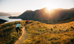
SaveLake Wanaka’s situation in the Southern Lakes of New Zealand gives it an unfair advantage. Soaring mountains yet trails that are well drained and rarely wet. A thriving mountain town, but with wilderness on it’s doorstep. Mountain Biking families, enthusiasts or even professionals – we have them all and we’ve got trails to keep you happy
source: Bike Wanaka
Links
Activities Click to view
- Mountain Bike
224 trails
- E-Bike
76 trails
- Gravel Bike
0 trails
- Adaptive Bike
0 trails
- Winter Fat Bike
0 trails
- Horse
4 trails
- Hike
161 trails
- Trail Running
163 trails
- ATV/ORV/OHV
3 trails
- Nordic Ski
20 trails
Region Details
- 17
- 5
- 32
- 76
- 13
- 37
- 15
Region Status
Caution as of 2 daysStats
- Avg Trail Rating
- Trails (view details)
- 221
- Trails Mountain Bike
- 224
- Trails E-Bike
- 76
- Trails Horse
- 4
- Trails Hike
- 161
- Trails Trail Running
- 163
- Trails Dirtbike/Moto
- 1
- Trails Observed Trials
- 1
- Trails ATV/ORV/OHV
- 3
- Trails Snowshoe
- 1
- Trails Backcountry Ski
- 2
- Trails Nordic Ski
- 20
- Total Distance
- 417 miles
- Total Descent
- 77,962 ft
- Total Vertical
- 5,633 ft
- Highest Trailhead
- 6,421 ft
- Reports
- 1,288
- Photos
- 873
- Ridden Counter
- 93,524
Articles

Video: The Resurrection of The Midpoint Jump Jam
Dec 2, 2022 from pinkbike.com
A re-launch of the Midpoint pro jump lines at Bike Glendhu in New Zealand turns out both local legends and few international pros.
Destination Showcase: Wānaka, New Zealand
Jan 19, 2021 from pinkbike.com
Everything you need to know about riding in Wānaka, New Zealand.

Video: Class is in Session for Blenki's Schralp School
Mar 11, 2020 from pinkbike.com
Sam Blenkinsop christens Glendhu Bike Park, just outside Wanaka, New Zealand, on the Norco Sight.
Sub Regions
-
Bike Glendhu Bike Park
- 3
- 4
- 3
- 2
-
Cardrona Bike Park NZ
- 2
- 9
- 1
- 6
- 7
-
Dublin Bay - Albert Town Recreation Reserve
- 1
- 2
-
Glendhu Bay
- 1
- 4
-
Hikuwai Conservation Area
- 1
- 1
- 6
- 6
- 3
-
Matukituki Valley
- 1
-
Pisa Range
- 7
- 2
-
Sticky Forest
- 1
- 7
- 24
- 18
- 5
Popular Wānaka Mountain Biking Trails
• 100 ★ 4.0 • 1,699 ft • 129 ft • 1,604 •
Highly rated popular green difficulty singletrack. This mountain bike primary trail can be used uphill only with a 129 ft green climb. On average it takes 4 minutes to complete this trail.
• 100 ★ 4.3 • 2,333 ft • 0 ft • 1,379 •
Some nice beginner gaps and berms. Gaps get bigger towards end.
• 100 ★ 4.0 • 2,005 ft • 0 ft • 1,271 •
Not the easiest line to find, splits between and , A few good jumps and berms. Watchout for the crossing of .
• 100 ★ 3.5 • 741 ft • 59 ft • 1,197 •
This trail is steep and is a good test of traction and climbing ability.
• 100 ★ 2.4 • 643 ft • 0 ft • 1,186 •
Popular blue difficulty singletrack. This mountain bike primary trail can be used downhill primary. On average it takes minutes to complete this trail.
• 95 ★ 3.2 • 2,070 ft • 159 ft • 1,182 •
Popular blue difficulty singletrack. This mountain bike primary trail can be used uphill only and has a moderate overall physical rating with a 159 ft blue climb. It features berm. Trail visibility is sometimes hard to follow. On average it takes 8 minutes to complete this trail.
• 80 ★ 3.7 • 1,273 ft • 0 ft • 1,132 •
A number of small to small/medium sized jumps and drops
Wānaka Mountain Bike Routes
33 miles • 1,671 ft • 1 • Loop •
It's a great one when it's too windy to road ride but serves as a great 'pedally' ride off road - Merryn
2 miles • 732 ft • 3 •
This is just a planning course for National XC Champs course. Please do not ride at this stage as this is...
★ 2.0 • 20 miles • 1,153 ft • 6 • Out & Back •
An easy scenic ride out to Albert Town via the Clutha River and back.
7 miles • 484 ft • 3 • Loop •
This route has a mix of single track, rough 4wd track (can have deep puddles after rain) and some tarseal...
★ 1.0 • 20 miles • 3,310 ft • 17 • Loop •
2022 Whyte Glendu Enduro 5 Stage
Photos of Wānaka Mountain Bike
Videos of Wānaka Mountain Bike

0:09 |
4 |
Nov 16, 2025

trail: Volume 2
0:10 |
134 |
Nov 16, 2022
trail: Volume 2
0:10 |
|
Nov 16, 2022

trail: Cajun Spice
2:00 |
162 |
Jul 6, 2022
trail: DARK MATTER
0:55 |
61 |
Jul 6, 2022

trail: Baywatch-Upper
3:13 |
64 |
Jun 1, 2022

trail: Baywatch Link
0:15 |
25 |
Jun 1, 2022
Current Trail Warnings
| status | trail | date | condition | user | info |
|---|---|---|---|---|---|
| Little Criffel Track | Jun 18, 2026 @ 11:45am (Pacific/Auckland) 2 days | Unknown | JoceScott | Unable to cross the river- too cold,... | |
| Backside 4WD Track | Jun 8, 2026 @ 3:02pm (Pacific/Auckland) Jun 7, 2026 | Unknown | bikeglendhubikepark | Closed for winter | |
| Jaiversion | Jun 8, 2026 @ 3:01pm (Pacific/Auckland) Jun 7, 2026 | Unknown | bikeglendhubikepark | Closed for winter |
Recent Trail Reports
| status | trail | date | condition | info | user |
|---|---|---|---|---|---|
| Deans Bank Track | Jun 18, 2026 @ 12:13pm (Pacific/Auckland) 2 days | Variable | JoceScott | ||
| Dublin Bay Track | Jun 18, 2026 @ 12:13pm (Pacific/Auckland) 2 days | Variable | JoceScott | ||
| Isthmus Peak Track | Jun 16, 2026 @ 11:45am (Pacific/Auckland) Jun 15, 2026 | Dry | JoceScott | ||
| MAIN ACCESS TO TRAILS | Jun 8, 2026 @ 2:57pm (Pacific/Auckland) Jun 7, 2026 | Unknown | bikeglendhubikepark | ||
| FERN BERMS | Jun 8, 2026 @ 2:57pm (Pacific/Auckland) Jun 7, 2026 | Unknown | bikeglendhubikepark | ||
| Don't Look Down | Jun 8, 2026 @ 2:57pm (Pacific/Auckland) Jun 7, 2026 | Unknown | bikeglendhubikepark | ||
| Flowgan Josh | Jun 8, 2026 @ 2:56pm (Pacific/Auckland) Jun 7, 2026 | Unknown | bikeglendhubikepark | ||
| Cajun Spice | Jun 8, 2026 @ 2:56pm (Pacific/Auckland) Jun 7, 2026 | Unknown | bikeglendhubikepark | ||
| Out Of Shape | Jun 8, 2026 @ 2:56pm (Pacific/Auckland) Jun 7, 2026 | Unknown | bikeglendhubikepark | ||
| Curly's Sweep | Jun 8, 2026 @ 2:56pm (Pacific/Auckland) Jun 7, 2026 | Unknown | bikeglendhubikepark |
Activity Feed
| username | action | type | title | date |
|---|---|---|---|---|
| JoceScott | add | report | activity #97307121 and 1 more | Jun 19, 2026 @ 4:17am 24 hours |
| JoceScott | add | report | activity #97291579 | Jun 18, 2026 @ 7:29pm 1 day |
| JoceScott | add | report | activity #97217428 | Jun 17, 2026 @ 4:45pm 2 days |
| JoceScott | add | report | activity #97138448 | Jun 16, 2026 @ 2:36pm Jun 16, 2026 |
| MisoDSn5VR | wishlist | route | activity #96857462 | Jun 13, 2026 @ 2:58am Jun 13, 2026 |
Recent Comments
| username | type | title | comment | date |
|---|---|---|---|---|
| trail | Climb is gradual and consistent, just a grind. | Feb 19, 2026 @ 11:39pm Feb 19, 2026 | ||
| trail | Out of this world views facing Mt Aspiring.... | Feb 19, 2026 @ 11:38pm Feb 19, 2026 | ||
| trail | Fine way to return to Wanaka after some... | Feb 19, 2026 @ 11:36pm Feb 19, 2026 | ||
| trail | The gap over Kooza is the best feature. Good fun. | Feb 19, 2026 @ 11:32pm Feb 19, 2026 | ||
| trail | Rutty and blown out most of the way, some... | Feb 19, 2026 @ 11:29pm Feb 19, 2026 |
Local Badges
-

Completionist0 awarded -

Big Ride 30k73 awarded -

Epic Ride 50k19 awarded -

Top 10 Trails0 awarded -
Top 10 Trails64 awarded -
Completionist0 awarded
Bike & Skill Parks
| name | type | city | rating |
|---|---|---|---|
| Cardrona Bike Park NZ | bike park | Wānaka | |
| Lismore Jump Park | skill park | Wānaka | |
| Newcastle Bike Park | skill park | Wānaka | |
| Hawea Bike Park | skill park | Wānaka | |
| Bike Glendhu Skills Area | skill park | Wānaka |
Upcoming Local Events
Local Trail Supporters
- upper clutha tramping club
Local Trail Supporters
- upper clutha tramping club
Activity Type Stats
| activitytype | trails | distance | descent | descent distance | total vertical | rating | global rank | state rank | photos | reports | routes | ridelogs |
|---|---|---|---|---|---|---|---|---|---|---|---|---|
| Mountain Bike | 224 | 332 miles | 58,642 ft | 134 miles | 5,417 ft | #105 | #7 | 830 | 1,287 | 14 | 41,326 | |
| E-Bike | 76 | 168 miles | 30,348 ft | 68 miles | 5,377 ft | #135 | #9 | 6 | 1,067 | 3 | 4,224 | |
| Horse | 4 | 16 miles | 997 ft | 4 miles | 4,518 ft | #211 | #6 | 167 | ||||
| Hike | 161 | 372 miles | 55,623 ft | 140 miles | 5,633 ft | #135 | #3 | 8 | 862 | 1 | 3,880 | |
| Trail Running | 163 | 374 miles | 55,764 ft | 140 miles | 5,633 ft | #156 | #4 | 863 | 1 | 3,661 | ||
| Dirtbike/Moto | 1 | 8 miles | 3,665 ft | 169 | 2 | |||||||
| Observed Trials | 1 | 8 miles | 3,665 ft | |||||||||
| ATV/ORV/OHV | 3 | 10 miles | 1,010 ft | 2 miles | 4,823 ft | #100 | #2 | 170 | 1 | |||
| Snowshoe | 1 | 1,453 ft | 7 ft | 410 ft | 26 ft | 32 | ||||||
| Backcountry Ski | 2 | 8 miles | 233 ft | 3,924 ft | 3,337 ft | 1 | 216 | |||||
| Nordic Ski | 20 | 26 miles | 2,060 ft | 9 miles | 3,438 ft | #99 | #1 | 1 | 404 |
Frequently Asked Questions About Wānaka
▼
What are the best places to ride in Wānaka?
Wānaka has 9 areas to explore for mountain biking. The top rated areas are:
▼
What are the highest rated mountain biking trails in Wānaka?
The highest rated mountain biking trails in Wānaka are:
- Deans Bank Track (4.6/5)
- Jairolla (4.6/5)
- HARE-TIME (4.6/5)
- Sweet As (4.5/5)
- Baywatch-Upper (4.5/5)
▼
What is the best time of the year to ride in Wānaka?
Based on ride log data, the most popular months to ride in Wānaka are:
- January (288 activities)
- February (225 activities)
- December (209 activities)
▼
Where can I park to ride in Wānaka?
There are 16 parking locations listed in Wānaka. The most popular parking spots are:
- Parking
- Parking
- Hāwea River Track Cemetery Road Parking Area
- Lakeside Trail Parking Area
- Sticky Forest Trail Head and Carpark
Activities
Trails
Points of Interest
- Maps/Information
- Highland Creek Hut Cabin
- Mt Cardrona (1936m) Summit
- Whitestar Express Quad Top Information
- Liverpool Stream Swinging Bridge
- French Ridge Hut Cabin
- Liverpool Hut Cabin
- Sticky Forest Summit
- Whitestar Express Quad Bottom Information
- McDougall's Chondola Bottom Information
- Rob Roy Peak (2,588 m)
- Mount Edward (2,581 m)
- Mount Maoriri (2,559 m)
- By chrisanz MBO & contributors
- Admins: Alps2Ocean-Cycle-Trail
- #4471 - 44,710 views
- wānaka activity log | embed map of Wānaka mountain bike trails | wānaka mountain biking points of interest polygons
Downloading of trail gps tracks in kml & gpx formats is enabled for Wānaka.
You must login to download files.