close
-
Layers w
- Weather Layers
- Pro
- Pro
- Pro
- Pro
- Pro
- Pro
- More Layers
- Pro
- Pro
- Pro
- Pro
-
Upgrade to

3D
Trail Conditions
- Unknown
- Snow Groomed
- Snow Packed
- Snow Covered
- Snow Cover Partial
- Freeze/thaw Cycle
- Icy
- Prevalent Mud
- Wet
- Variable
- Ideal
- Dry
- Very Dry
Trail Flow (Ridden Direction)
Trailforks scans users ridelogs to determine the most popular direction each trail is ridden. A good flowing trail network will have most trails flowing in a single direction according to their intension.
The colour categories are based on what percentage of riders are riding a trail in its intended direction.
The colour categories are based on what percentage of riders are riding a trail in its intended direction.
- > 96%
- > 90%
- > 80%
- > 70%
- > 50%
- < 50%
- bi-directional trail
- no data
Trail Last Ridden
Trailforks scans ridelogs to determine the last time a trail was ridden.
- < 2 days
- < 1 week
- < 2 weeks
- < 1 month
- < 6 months
- > 6 months
Trail Ridden Direction
The intended direction a trail should be ridden.
- Downhill Only
- Downhill Primary
- Both Directions
- Uphill Primary
- Uphill Only
- One Direction
Contribute Details
Colors indicate trail is missing specified detail.
- Description
- Photos
- Description & Photos
- Videos
Trail Popularity ?
Trailforks scans ridelogs to determine which trails are ridden the most in the last 9 months.
Trails are compared with nearby trails in the same city region with a possible 25 colour shades.
Think of this as a heatmap, more rides = more kinetic energy = warmer colors.
- most popular
- popular
- less popular
- not popular
ATV/ORV/OHV Filter
Max Vehicle Width
inches
US Cell Coverage
Legend

Radar Time
Activity Recordings
Trailforks uses anonymized public activity data.
?
Activity Recordings
Trailforks uses anonymized public activity data.
?
Personal Heatmap
▶
Activity Types
all
/
none
▶
Options
2
Date range
month
–
Winter Trails
Warning
A routing network for winter maps does not exist. Selecting trails using the winter trails layer has been disabled.
Missing Trails
Most Popular
Least Popular
Trails are colored based on popularity. The more popular a trail is, the more red. Less popular trails trend towards green.
Jump Magnitude Heatmap
Heatmap of where riders jump on trails. Zoom in to see individual jumps, click circles to view jump details.
BC Backroad Status
![map legend]()
Service Road Atlas is a free to use, community-driven service for viewing and creating reports on the numerous back-country service roads around B.C. and Alberta.

Slope Aspect
Direction the slope faces
Trails Deemphasized
Trails are shown in grey.
Only show trails with no bike usage.
Suggested Layers
Based on selected activity type
Save the current map location and zoom level as your default home location whenever this page is loaded.
Save
No description for Durris has been added yet!
Login or register to submit one.
This region uses the Uk/Euro style trail grading system.
Region Supporters & Maintainers
![]()
Gravitate North EastSponsor
Activities Click to view
- Mountain Bike
64 trails
- E-Bike
56 trails
- Gravel Bike
0 trails
- Adaptive Bike
0 trails
- Winter Fat Bike
0 trails
- Horse
21 trails
- Hike
49 trails
- Trail Running
49 trails
Region Details
- 25
- 2
- 18
- 14
- 5
Region Status
Caution as of Apr 27, 2026Stats
- Avg Trail Rating
- Trails (view details)
- 64
- Trails Mountain Bike
- 64
- Trails E-Bike
- 56
- Trails Horse
- 21
- Trails Hike
- 49
- Trails Trail Running
- 49
- Total Distance
- 36 miles
- Total Descent
- 9,140 ft
- Total Vertical
- 974 ft
- Highest Trailhead
- 1,222 ft
- Reports
- 497
- Photos
- 74
- Ridden Counter
- 5,229
Sub Regions
-
Brachmont Wood
- 3
-
Clune Wood
- 1
- 2
- 1
-
Durris Forest
- 1
- 6
- 11
- 5
-
Warren Wood
- 5
- 1
Popular Durris Mountain Biking Trails
• 70 ★ 1.0 • 2,126 ft • 119 ft • 233 • • hike
climb to top of trail ,steep long climb , technical in places. Slopfest
• 70 ★ 3.9 • 2,943 ft • 4 ft • 217 •
Popular red difficulty singletrack. This mountain bike primary trail can be used downhill only. On average it takes 7 minutes to complete this trail.
Durris 1 Permanently Closed
• 60 ★ 4.2 • 1,726 ft • 0 ft • 201 •
Highly rated moderately popular red difficulty closed singletrack. This mountain bike primary trail can be used downhill only and has a moderate overall physical rating with a 0 ft green climb. It features berm, drop, jump and gap jump. Trail visibility is always easy to follow. On average it takes 2 minutes to complete this trail.
• 75 ★ 4.6 • 2,661 ft • 0 ft • 173 •
Popular red difficulty singletrack. This mountain bike primary trail can be used downhill only and has a moderate overall physical rating. Trail visibility is sometimes hard to follow. On average it takes 6 minutes to complete this trail.
• 80 ★ 3.0 • 3,114 ft • 0 ft • 172 •
Popular black difficulty singletrack. This mountain bike primary trail can be used downhill primary. On average it takes 7 minutes to complete this trail.
• 70 ★ 2.4 • 1,775 ft • 0 ft • 172 •
very muddy trail , very dark ,takes you from top of mast to bottom where there are more trails
• 95 ★ 4.6 • 2,559 ft • 0 ft • 167 •
Popular black difficulty singletrack. This mountain bike primary trail can be used one direction. On average it takes 4 minutes to complete this trail.
Durris Mountain Bike Routes
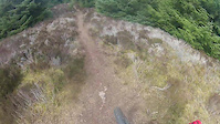
Photos of Durris Mountain Bike
Videos of Durris Mountain Bike
trail: Powered up PacMan
4:48 |
193 |
Apr 29, 2020
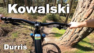
trail: Kowalski
4:15 |
352 |
May 13, 2022 , Durris
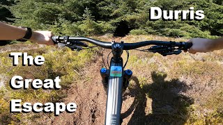
trail: Great Escape
4:00 |
423 |
May 11, 2022 , Durris
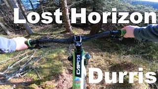
trail: Lost Horizon
4:04 |
579 |
May 13, 2021 , Durris

trail: Right down
3:14 |
415 |
Jul 3, 2020 , Durris

trail: Brick Killed a Man
4:22 |
777 |
Jul 2, 2020 , Durris
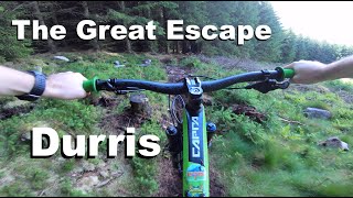
trail: Great Escape
3:45 |
535 |
Jul 1, 2020 , Durris
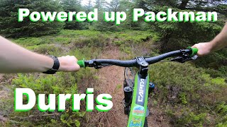
trail: Powered up PacMan
4:12 |
678 |
Jun 11, 2020 , Durris
Recent Trail Reports
| status | trail | date | condition | info | user |
|---|---|---|---|---|---|
| Lost Horizon | Apr 27, 2026 @ 6:00pm (Europe/London) Apr 27, 2026 | Variable | felasmor | ||
| Powered up PacMan | Apr 6, 2026 @ 12:24pm (Europe/London) Apr 6, 2026 | Variable | w0rldexplorer | ||
| Great Escape | Apr 6, 2026 @ 12:24pm (Europe/London) Apr 6, 2026 | Variable | w0rldexplorer | ||
| Glass Case of Emotion | Mar 31, 2026 @ 6:05pm (Europe/London) Mar 31, 2026 | Unknown | LukeHunter83 | ||
| Forest Road | Jan 18, 2026 @ 11:06am (Europe/London) Jan 18, 2026 | Icy | richardcain2 | ||
| Kowalski | Nov 9, 2025 @ 2:32pm (Europe/London) Nov 9, 2025 | Variable | w0rldexplorer | ||
| Edge of Chaos | Aug 26, 2025 @ 10:27am Aug 26, 2025 | Unknown | LukeHunter83 | ||
| Mast doon! | Jun 9, 2025 @ 1:18am Jun 9, 2025 | Unknown | w0rldexplorer | ||
| Forest Road | Jun 3, 2025 @ 3:56pm Jun 3, 2025 | Ideal | Lusciousleeta | ||
| Forest Road | Jun 3, 2025 @ 3:56pm Jun 3, 2025 | Ideal | Lusciousleeta |
Activity Feed
| username | action | type | title | date |
|---|---|---|---|---|
| tom-tbt | update | trail | activity #96079351 | Jun 2, 2026 @ 6:26am Jun 2, 2026 |
| tom-tbt | add | trail | activity #96070674 | Jun 2, 2026 @ 3:00am Jun 2, 2026 |
| Rossy55 | ridden | trail | activity #94081538 and 7 more | May 5, 2026 @ 4:37am May 5, 2026 |
| felasmor | add | report | activity #93524711 | Apr 27, 2026 @ 10:01am Apr 27, 2026 |
| Stoneymin | comment | report | activity #93434748 | Apr 26, 2026 @ 6:04am Apr 26, 2026 |
Recent Comments
| username | type | title | comment | date |
|---|---|---|---|---|
| report | Feel free to build on the line. Quickly built... | Apr 26, 2026 @ 6:04am Apr 26, 2026 | ||
| report | Nice, though a new high line would work but... | Apr 21, 2026 @ 6:19am Apr 21, 2026 | ||
| report | New temporary (or not) high line diversion put... | Apr 12, 2026 @ 12:30pm Apr 12, 2026 | ||
| trail | As of 21st of Feb, it is partly closed due... | Feb 21, 2026 @ 12:17pm Feb 21, 2026 | ||
| trail | Walked the trail, cleared all debris. | May 22, 2025 @ 10:56am May 22, 2025 |
Local Badges
-

Epic Ride Climb 2k5 awarded -

Climbing 10k Badge27 awarded -

Climbing 100k Badge0 awarded -

Epic Ride Descent 2k5 awarded -

Descent 10k Badge27 awarded -

Descent 100k Badge0 awarded
Activity Type Stats
| activitytype | trails | distance | descent | descent distance | total vertical | rating | global rank | state rank | photos | reports | routes | ridelogs |
|---|---|---|---|---|---|---|---|---|---|---|---|---|
| Mountain Bike | 64 | 36 miles | 9,140 ft | 20 miles | 974 ft | #3,476 | #115 | 70 | 497 | 3 | 3,639 | |
| E-Bike | 56 | 33 miles | 8,681 ft | 19 miles | 961 ft | #3,152 | #108 | 4 | 460 | 367 | ||
| Horse | 21 | 21 miles | 1,913 ft | 10 miles | 879 ft | #1,435 | #75 | 74 | ||||
| Hike | 49 | 31 miles | 4,672 ft | 15 miles | 974 ft | #5,272 | #119 | 361 | 100 | |||
| Trail Running | 49 | 31 miles | 4,672 ft | 15 miles | 974 ft | #5,141 | #117 | 361 | 91 |
Frequently Asked Questions About Durris
▼
What are the best places to ride in Durris?
Durris has 4 areas to explore for mountain biking. The top rated areas are:
▼
What are the highest rated mountain biking trails in Durris?
The highest rated mountain biking trails in Durris are:
- Great Escape (4.3/5)
- Edge of Chaos (4.3/5)
- Lost Horizon (4.2/5)
- Kowalski (4/5)
- Boom (4/5)
▼
What is the best time of the year to ride in Durris?
Based on ride log data, the most popular months to ride in Durris are:
- July (39 activities)
- September (33 activities)
- June (28 activities)
▼
Where can I park to ride in Durris?
There are 6 parking locations listed in Durris. The most popular parking spots are: View all parking and trailhead locations on the map to plan your visit.
Activities
Trails
Points of Interest
- durris activity log | embed map of Durris mountain bike trails | durris mountain biking points of interest
Downloading of trail gps tracks in kml & gpx formats is enabled for Durris.
You must login to download files.