close
-
Layers w
- Weather Layers
- Pro
- Pro
- Pro
- Pro
- Pro
- Pro
- More Layers
- Pro
- Pro
- Pro
- Pro
-
Upgrade to

3D
Trail Conditions
- Unknown
- Snow Groomed
- Snow Packed
- Snow Covered
- Snow Cover Partial
- Freeze/thaw Cycle
- Icy
- Prevalent Mud
- Wet
- Variable
- Ideal
- Dry
- Very Dry
Trail Flow (Ridden Direction)
Trailforks scans users ridelogs to determine the most popular direction each trail is ridden. A good flowing trail network will have most trails flowing in a single direction according to their intension.
The colour categories are based on what percentage of riders are riding a trail in its intended direction.
The colour categories are based on what percentage of riders are riding a trail in its intended direction.
- > 96%
- > 90%
- > 80%
- > 70%
- > 50%
- < 50%
- bi-directional trail
- no data
Trail Last Ridden
Trailforks scans ridelogs to determine the last time a trail was ridden.
- < 2 days
- < 1 week
- < 2 weeks
- < 1 month
- < 6 months
- > 6 months
Trail Ridden Direction
The intended direction a trail should be ridden.
- Downhill Only
- Downhill Primary
- Both Directions
- Uphill Primary
- Uphill Only
- One Direction
Contribute Details
Colors indicate trail is missing specified detail.
- Description
- Photos
- Description & Photos
- Videos
Trail Popularity ?
Trailforks scans ridelogs to determine which trails are ridden the most in the last 9 months.
Trails are compared with nearby trails in the same city region with a possible 25 colour shades.
Think of this as a heatmap, more rides = more kinetic energy = warmer colors.
- most popular
- popular
- less popular
- not popular
ATV/ORV/OHV Filter
Max Vehicle Width
inches
US Cell Coverage
Legend

Radar Time
Activity Recordings
Trailforks uses anonymized public activity data.
?
Activity Recordings
Trailforks uses anonymized public activity data.
?
Personal Heatmap
▶
Activity Types
all
/
none
▶
Options
2
Date range
month
–
Winter Trails
Warning
A routing network for winter maps does not exist. Selecting trails using the winter trails layer has been disabled.
Missing Trails
Most Popular
Least Popular
Trails are colored based on popularity. The more popular a trail is, the more red. Less popular trails trend towards green.
Jump Magnitude Heatmap
Heatmap of where riders jump on trails. Zoom in to see individual jumps, click circles to view jump details.
BC Backroad Status
![map legend]()
Service Road Atlas is a free to use, community-driven service for viewing and creating reports on the numerous back-country service roads around B.C. and Alberta.

Slope Aspect
Direction the slope faces
Trails Deemphasized
Trails are shown in grey.
Only show trails with no bike usage.
Suggested Layers
Based on selected activity type
Save the current map location and zoom level as your default home location whenever this page is loaded.
SaveSet amongst the towering jarrah forests of Western Australia’s Peel region, Dwellingup has earned its reputation as one of the state’s premier mountain biking destinations. More than just a trail network, Dwellingup is a true trail town — a place where riding begins in the heart of town and extends deep into forested hills, river valleys and purpose-built singletrack.
What makes Dwellingup stand out is the diversity of the riding on offer. Riders can spend the day flowing through forest singletrack, tackling classic cross-country terrain, chasing gravity-inspired descents or linking into long-distance backcountry adventures. From smooth beginner-friendly trails close to town to technical riding and longer wilderness loops, the region offers something for every style of mountain biker.
Unlike destinations built around a single mountain or bike park, Dwellingup is made up of several distinct ride areas, each with its own character. The historic cross-country trails around Marrinup showcase the area’s deep mountain biking roots, Turner Hill brings a more modern flavour with flowing descents and gravity-style laps, while Murray Valley delivers bigger terrain and scenic riding through the Murray River valley. Together, they create a destination capable of keeping riders entertained for a weekend — or much longer.
Dwellingup also sits on the route of the iconic Munda Biddi Trail, one of the world’s longest off-road cycling routes, making the town a natural base for riders looking to extend their adventure beyond the local singletrack.
With trailheads close to town, rider-friendly facilities and a growing reputation as an outdoor adventure hub, Dwellingup offers a mountain biking experience that combines purpose-built trails with the freedom of riding through vast forest landscapes. Whether you are chasing fast flow, technical singletrack or long days in the saddle, Dwellingup delivers one of Western Australia’s most complete mountain biking experiences.
Primary Trail Type: Cross-Country
Land Status: Crown Land
Disclaimer:
At the heart of Dwellingup’s trail experience is the Dwellingup Trails and Visitor Centre, located at 2 Marinup Street, Dwellingup WA 6213. Purpose-built as the town’s central trail hub, it is the ideal first stop for mountain bikers looking to get their bearings, pick up maps and local advice, or plan the best ride for their skill level and available time. The centre provides up-to-date trail information, local knowledge and rider support, while the surrounding precinct includes rider-friendly facilities such as parking, public toilets, showers, bike wash stations, lockers, a pump track and skate park. Riders will also find easy access to nearby cafés, accommodation and gear hire, making it a convenient base before or after a ride. For enquiries, the centre can be contacted on (+61  9538 1108.
Activities Click to view
- Mountain Bike
120 trails
- E-Bike
122 trails
- Gravel Bike
29 trails
- Adaptive Bike
5 trails
- Winter Fat Bike
0 trails
- Horse
3 trails
- Hike
57 trails
- Trail Running
61 trails
Region Details
- 51
- 29
- 35
- 5
Region Status
Open as of Jun 16, 2026Stats
- Avg Trail Rating
- Trails (view details)
- 125
- Trails Mountain Bike
- 122
- Trails E-Bike
- 122
- Trails Gravel Bike
- 29
- Trails Adaptive Bike
- 5
- Trails Horse
- 3
- Trails Hike
- 57
- Trails Trail Running
- 61
- Total Distance
- 202 miles
- Total Descent
- 24,782 ft
- Total Vertical
- 1,431 ft
- Highest Trailhead
- 1,872 ft
- Reports
- 715
- Photos
- 150
- Ridden Counter
- 19,161
Sub Regions
-
Dwellingup Mountain Bike Trails
- 18
- 19
-
Murray Valley
- 8
- 9
- 3
-
Tom's Crossing MTB
-
Turner Hill
- 2
- 2
- 1
Popular Dwellingup Mountain Biking Trails
• 100 ★ 3.8 • 1 mile • 20 ft • 859 •
is a 2.3km descending green trail suitable for beginners. The trail features open rolling grade reversals, large cambered turns and flowing features on wide smooth surface.
• 100 ★ 4.4 • 4,511 ft • 0 ft • 837 •
is a 1.4km blue downhill flow trail which has large natural surfaced features such as table tops, step downs and step ups, rollers and berms.
• 100 ★ 4.0 • 3,881 ft • 279 ft • 825 •
Popular blue difficulty singletrack. This mountain bike primary trail can be used one direction. On average it takes 8 minutes to complete this trail.
• 100 ★ 4.5 • 1 mile • 19 ft • 789 •
Top section XC style, flowing, slight downhill. Mid section steeper, many tight berms. Lower half fast, flowing, super fun.
• 100 ★ 4.0 • 3,461 ft • 102 ft • 728 •
An access trail to Inzamia, Karackatoa and downhill trails from The Roost shuttle trailhead. An alternative access trail to Fault Line. Some features to add interest such as a log ride, small rock gardens, stump drop jump, and a burnt...
• 100 ★ 5.0 • 1 mile • 238 ft • 673 •
Popular green difficulty singletrack. This mountain bike primary trail can be used one direction. On average it takes 11 minutes to complete this trail.
• 100 ★ 3.8 • 1 mile • 382 ft • 611 •
Easy gradients, flowing in lower half. Gradient increases gradually in upper half. Tight switchbacks and steeper grades in upper third.
• 95 ★ 3.8 • 4,272 ft • 80 ft • 611 •
All mountain trail, some downhill in first half, climbing in last third. Mainly an access trail from climb to Shuttle trail head area.
Dwellingup Mountain Bike Routes
★ 5.0 • 38 miles • 3,575 ft • 3 • Loop •
This is a great way to prepare for the Dwellingup 100 by seeing a major portion of the past years race...
★ 5.0 • 18 miles • 1,134 ft • 2 • Point to Point •
Outdoor Recreation students will be arriving by bus to Marrinup and will be riding the Munda Biddi...
16 miles • 2,030 ft • 19 • Loop •
Meet at the trailhead. All climbs are spaced out. Route ends at a point that allows various options to go...
8 miles • 642 ft • 4 •
A nice cruisey ride out from the main Dwelligup campsite taking in the Marrinup and surrounding trails.
Photos of Dwellingup Mountain Bike
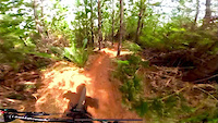
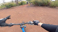
Videos of Dwellingup Mountain Bike
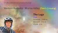
trail: The Luge
0:26 |
91 |
Jul 4, 2025
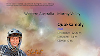
trail: Quokkamoly
4:55 |
56 |
Jan 25, 2025

trail: Busted Nuts
4:08 |
63 |
Jan 25, 2025

trail: Mayhem
5:59 |
65 |
Jan 25, 2025

trail: Devils Pass
4:47 |
43 |
Jan 25, 2025

trail: Slingshot
4:18 |
53 |
Jan 25, 2025
trail: The Luge
4:22 |
45 |
Jan 25, 2025
trail: Busted Nuts
0:03 |
427 |
Apr 23, 2021
Recent Trail Reports
| status | trail | date | condition | info | user |
|---|---|---|---|---|---|
| Munda Biddi - Oakley Dam To Nanga 2 [Realignment] | Jun 17, 2026 @ 12:42pm (Australia/Perth) Jun 16, 2026 | Ideal | sweatytechie MTBWA | ||
| Tunnel Vision | Jun 17, 2026 @ 12:13pm (Australia/Perth) Jun 16, 2026 | Unknown | sweatytechie MTBWA | ||
| Tidy's Maggot Attack | Jun 17, 2026 @ 12:13pm (Australia/Perth) Jun 16, 2026 | Unknown | sweatytechie MTBWA | ||
| Run to the Power Up | Jun 17, 2026 @ 12:13pm (Australia/Perth) Jun 16, 2026 | Unknown | sweatytechie MTBWA | ||
| Piglets | Jun 17, 2026 @ 12:13pm (Australia/Perth) Jun 16, 2026 | Unknown | sweatytechie MTBWA | ||
| Ol Skool Hollywood | Jun 17, 2026 @ 12:13pm (Australia/Perth) Jun 16, 2026 | Unknown | sweatytechie MTBWA | ||
| Mother Hubbard | Jun 17, 2026 @ 12:13pm (Australia/Perth) Jun 16, 2026 | Unknown | sweatytechie MTBWA | ||
| Forrest Gump | Jun 17, 2026 @ 12:13pm (Australia/Perth) Jun 16, 2026 | Unknown | sweatytechie MTBWA | ||
| Down N Up | Jun 17, 2026 @ 12:13pm (Australia/Perth) Jun 16, 2026 | Unknown | sweatytechie MTBWA | ||
| Billy Boblob Law | Jun 17, 2026 @ 12:13pm (Australia/Perth) Jun 16, 2026 | Unknown | sweatytechie MTBWA |
Activity Feed
| username | action | type | title | date |
|---|---|---|---|---|
| sweatytechie | update | trail | activity #97233206 | Jun 17, 2026 @ 10:33pm 3 days |
| ChrisBan21 | update | trail | activity #97184233 | Jun 17, 2026 @ 8:03am Jun 17, 2026 |
| ChrisBan21 | update | trail | activity #97175315 | Jun 17, 2026 @ 5:10am Jun 17, 2026 |
| ChrisBan21 | update | trail | activity #97174490 | Jun 17, 2026 @ 4:51am Jun 17, 2026 |
| sweatytechie | update | region | activity #97166726 | Jun 17, 2026 @ 12:28am Jun 17, 2026 |
Recent Comments
| username | type | title | comment | date |
|---|---|---|---|---|
| trail | Fantastic new trail. The climb is pretty solid... | May 20, 2026 @ 10:28pm May 20, 2026 | ||
| trail | nice | Aug 11, 2025 @ 7:20pm Aug 11, 2025 | ||
| trail | This is a great trail! Fast, flowy, all the... | Mar 3, 2025 @ 4:11pm Mar 3, 2025 | ||
| trail | Nice easy flow trail. Some of the berms are... | Mar 3, 2025 @ 4:09pm Mar 3, 2025 | ||
| trail | Awesome flow trail. Looks like it's had a bit... | Mar 3, 2025 @ 4:07pm Mar 3, 2025 |
Local Badges
-

Epic Ride Climb 2k152 awarded -

Climbing 10k Badge129 awarded -

Climbing 100k Badge7 awarded -

Epic Ride Descent 2k160 awarded -

Descent 10k Badge135 awarded -

Descent 100k Badge7 awarded
Upcoming Local Events
Local Trail Supporters
- http://magicdirt.com.au/
- Loztrails
- https://www.facebook.com/loztrails/
Local Trail Supporters
- http://magicdirt.com.au/
- Loztrails
- https://www.facebook.com/loztrails/
Activity Type Stats
| activitytype | trails | distance | descent | descent distance | total vertical | rating | global rank | state rank | photos | reports | routes | ridelogs |
|---|---|---|---|---|---|---|---|---|---|---|---|---|
| Mountain Bike | 120 | 161 miles | 19,780 ft | 66 miles | 771 ft | #711 | #39 | 150 | 714 | 11 | 15,570 | |
| E-Bike | 122 | 161 miles | 19,780 ft | 66 miles | 771 ft | #559 | #47 | 639 | 1 | 1,584 | ||
| Gravel Bike | 29 | 67 miles | 6,923 ft | 30 miles | 1,401 ft | #62 | #78 | 22 | 18 | |||
| Adaptive Bike | 5 | 5 miles | 364 ft | 2 miles | 522 ft | #143 | #135 | 14 | ||||
| Horse | 3 | 2 miles | 226 ft | 4,170 ft | 167 ft | #651 | #33 | 139 | 1 | 2 | ||
| Hike | 57 | 109 miles | 10,430 ft | 48 miles | 1,417 ft | #1,674 | #51 | 565 | 1 | 182 | ||
| Trail Running | 61 | 115 miles | 10,748 ft | 50 miles | 1,417 ft | #1,207 | #38 | 581 | 1 | 126 |
Frequently Asked Questions About Dwellingup
▼
What are the best places to ride in Dwellingup?
Dwellingup has 6 areas to explore for mountain biking. The top rated areas are:
▼
What are the highest rated mountain biking trails in Dwellingup?
The highest rated mountain biking trails in Dwellingup are:
- Blaze (4.5/5)
- Busted Nuts (4.4/5)
- Marrinup Circuit (4.3/5)
- Inzamia (4.2/5)
- Boom Boom (4.2/5)
▼
What is the best time of the year to ride in Dwellingup?
Based on ride log data, the most popular months to ride in Dwellingup are:
- September (227 activities)
- October (211 activities)
- December (204 activities)
▼
Where can I park to ride in Dwellingup?
There are 6 parking locations listed in Dwellingup. The most popular parking spots are: View all parking and trailhead locations on the map to plan your visit.
Activities
Trails
- By Jake-Hannah
 MPTA & contributors
 - Admins: MTBWA
- #5915 - 26,417 views
- dwellingup activity log | embed map of Dwellingup mountain bike trails | dwellingup mountain biking points of interest
Downloading of trail gps tracks in kml & gpx formats is enabled for Dwellingup.
You must login to download files.