close
-
Layers w
- Weather Layers
- Pro
- Pro
- Pro
- Pro
- Pro
- Pro
- More Layers
- Pro
- Pro
- Pro
- Pro
-
Upgrade to

3D
Trail Conditions
- Unknown
- Snow Groomed
- Snow Packed
- Snow Covered
- Snow Cover Partial
- Freeze/thaw Cycle
- Icy
- Prevalent Mud
- Wet
- Variable
- Ideal
- Dry
- Very Dry
Trail Flow (Ridden Direction)
Trailforks scans users ridelogs to determine the most popular direction each trail is ridden. A good flowing trail network will have most trails flowing in a single direction according to their intension.
The colour categories are based on what percentage of riders are riding a trail in its intended direction.
The colour categories are based on what percentage of riders are riding a trail in its intended direction.
- > 96%
- > 90%
- > 80%
- > 70%
- > 50%
- < 50%
- bi-directional trail
- no data
Trail Last Ridden
Trailforks scans ridelogs to determine the last time a trail was ridden.
- < 2 days
- < 1 week
- < 2 weeks
- < 1 month
- < 6 months
- > 6 months
Trail Ridden Direction
The intended direction a trail should be ridden.
- Downhill Only
- Downhill Primary
- Both Directions
- Uphill Primary
- Uphill Only
- One Direction
Contribute Details
Colors indicate trail is missing specified detail.
- Description
- Photos
- Description & Photos
- Videos
Trail Popularity ?
Trailforks scans ridelogs to determine which trails are ridden the most in the last 9 months.
Trails are compared with nearby trails in the same city region with a possible 25 colour shades.
Think of this as a heatmap, more rides = more kinetic energy = warmer colors.
- most popular
- popular
- less popular
- not popular
ATV/ORV/OHV Filter
Max Vehicle Width
inches
US Cell Coverage
Legend

Radar Time
Activity Recordings
Trailforks uses anonymized public activity data.
?
Activity Recordings
Trailforks uses anonymized public activity data.
?
Personal Heatmap
▶
Activity Types
all
/
none
▶
Options
2
Date range
month
–
Winter Trails
Warning
A routing network for winter maps does not exist. Selecting trails using the winter trails layer has been disabled.
Missing Trails
Most Popular
Least Popular
Trails are colored based on popularity. The more popular a trail is, the more red. Less popular trails trend towards green.
Jump Magnitude Heatmap
Heatmap of where riders jump on trails. Zoom in to see individual jumps, click circles to view jump details.
BC Backroad Status
![map legend]()
Service Road Atlas is a free to use, community-driven service for viewing and creating reports on the numerous back-country service roads around B.C. and Alberta.

Slope Aspect
Direction the slope faces
Trails Deemphasized
Trails are shown in grey.
Only show trails with no bike usage.
Suggested Layers
Based on selected activity type
Save the current map location and zoom level as your default home location whenever this page is loaded.
Save
No description for Coedwig Dyfi Forest has been added yet!
Login or register to submit one.
 google parking directions
google parking directionsLinks
This region uses the Uk/Euro style trail grading system.
Activities Click to view
- Mountain Bike
123 trails
- E-Bike
85 trails
- Horse
42 trails
- Hike
87 trails
- Trail Running
87 trails
Region Details
- 40
- 3
- 9
- 32
- 19
- 3
Region Status
Caution as of May 15, 2026Stats
- Avg Trail Rating
- Trails (view details)
- 110
- Trails Mountain Bike
- 123
- Trails E-Bike
- 85
- Trails Horse
- 42
- Trails Hike
- 87
- Trails Trail Running
- 87
- Trails Dirtbike/Moto
- 1
- Total Distance
- 120 miles
- Total Descent
- 34,833 ft
- Total Vertical
- 2,802 ft
- Highest Trailhead
- 2,851 ft
- Reports
- 432
- Photos
- 180
- Ridden Counter
- 22,754
Articles
Must Watch: Gee Atherton Turns Storm-Shattered Dyfi Hillside Into A Wild New Line in ‘Windfell’
Nov 27, 2025 from pinkbike.com
Gee is a certified freak on the bike.

Video: Jim Monro Tears Up a Freshly Groomed Dyfi Bikepark
Jul 7, 2025 from pinkbike.com
Jim Monro, fresh turns, packed lips, and an empty Dyfi Bikepark. That's some good watching.

Video: Becci Skelton Everesting at Dyfi Bike Park For A Good Cause.
Jul 2, 2025 from pinkbike.com
25 laps up and down the gruelling trails of Dyfi. This is a rad effort.
Video: Dan and Gee Atherton Test the S.200 on Home Soil
Mar 5, 2025 from pinkbike.com
It’s always rad to see the Atherton brothers swinging a leg over their own machines and shredding together.
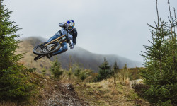
Popular Coedwig Dyfi Forest Mountain Biking Trails
• 100 ★ 4.7 • 2 miles • 0 ft • 1,024 •
Rail the berms & enjoy that flowing feeling then launch yourself into some small but perfectly formed jumps before finishing with more berms and the flat-out exhilaration of riding the shred road!
• 100 ★ 4.0 • 1,847 ft • 0 ft • 918 •
Popular red difficulty mixed. This mountain bike primary trail can be used downhill only. It features berm, drop and jump. On average it takes 3 minutes to complete this trail.
• 100 ★ 4.7 • 2 miles • 27 ft • 716 •
Fast rocky sections lead into 3 table tops before dropping into tight corners that shoot you into more tight corners. Bermed and rutted, with natural senders and flat out bus stops, this track races down hill at a perfect gradient and...
• 100 ★ 5.0 • 3,566 ft • 31 ft • 710 •
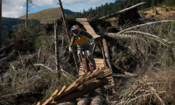
starts out technical with rocky, rooty drops and berms then gets fast and fun, spitting you out into three big table tops before sending you over the iconic bridges. Try the Road Gap, then step up onto the largest roundwood timber...
• 95 ★ 4.6 • 2 miles • 20 ft • 708 •
starts in the path of the RAF Low Fly Zone, with over 8 mins of flowing table tops this track is best suited to Enduro bikes.
• 95 ★ 4.9 • 2 miles • 39 ft • 699 •
Section 8 of Climachx. One of the longest purpose built, unbroken downhill descents in the UK with a tricky rock garden climb to earn your reward.
Coedwig Dyfi Forest Mountain Bike Routes
★ 4.0 • 9 miles • 1,911 ft • 10 • Loop •
The cli-machx was built in 2005 and is sited in the Dyfi forest; now looked after by Beicio Mynydd Dyfi...
★ 4.0 • 24 miles • 4,226 ft • 10 • Loop •
The Best of Dyfi's official unofficial trails! A fantastic day on the bike!
★ 4.0 • 13 miles • 1,329 ft • 0 • Loop •
This is a fast rather than technical trail, taking you steeply upwards and fast downwards with some epic...
★ 3.7 • 14 miles • 1,785 ft • 0 • Loop •
The classic cross country mountain biking trail: This trail offers a perfect mix of XC riding, the taxing...
★ 3.0 • 21 miles • 2,411 ft • 0 • Loop •
The big one: Expect long climbs and challenging descents that will cook your legs and test your skills –...
• 23 miles • 7,358 ft • 10 •
Photos of Coedwig Dyfi Forest Mountain Bike
Videos of Coedwig Dyfi Forest Mountain Bike
trail: Super Swooper
0:10 |
106 |
Oct 2, 2022
trail: Turns In The Ferns
0:13 |
107 |
Jun 30, 2022

trail: Race Track
0:28 |
63 |
Oct 2, 2021

trail: Slab Track
0:16 |
413 |
Oct 2, 2021
trail: 50 Hits
2:49 |
242 |
Nov 25, 2020
trail: Super Swooper
11:21 |
109 |
Nov 15, 2020
trail: Hazel Builth
2:10 |
436 |
Feb 7, 2020
trail: Tony the Tiger
4:48 |
504 |
Feb 7, 2020
Recent Trail Reports
| status | trail | date | condition | info | user |
|---|---|---|---|---|---|
| Nemisis | May 15, 2026 @ 2:57pm (Europe/London) May 15, 2026 | Unknown | EddietBRtsN | ||
| Turns In The Ferns | Apr 18, 2026 @ 10:23am (Europe/Isle_of_Man) Apr 18, 2026 | Ideal | RadBikeBro NCTC | ||
| Insta 360 Flow State | Apr 18, 2026 @ 10:23am (Europe/Isle_of_Man) Apr 18, 2026 | Variable | RadBikeBro NCTC | ||
| 50 Hits | Apr 18, 2026 @ 10:23am (Europe/Isle_of_Man) Apr 18, 2026 | Ideal | RadBikeBro NCTC | ||
| Muddy's Berms | Apr 18, 2026 @ 10:23am (Europe/Isle_of_Man) Apr 18, 2026 | Variable | RadBikeBro NCTC | ||
| Original DH | Apr 18, 2026 @ 10:23am (Europe/Isle_of_Man) Apr 18, 2026 | Variable | RadBikeBro NCTC | ||
| M&M's | Nov 6, 2025 @ 6:05pm (Europe/London) Nov 6, 2025 | Variable | benjeman | ||
| Elephant | Oct 24, 2025 @ 12:34pm (Europe/London) Oct 24, 2025 | Unknown | Dyfiboi | ||
| Three Lords Gravity Enduro | Aug 13, 2025 @ 1:02am Aug 13, 2025 | Ideal | mikeb46 | ||
| Tony the Tiger | Aug 13, 2025 @ 1:01am Aug 13, 2025 | Ideal | mikeb46 |
Activity Feed
| username | action | type | title | date |
|---|---|---|---|---|
| MisoDSn5VR | wishlist | route | activity #97093927 and 2 more | Jun 16, 2026 @ 1:24am 3 days |
| Award | wishlist | trail | activity #96691521 | Jun 10, 2026 @ 1:02pm Jun 10, 2026 |
| Dazzlemus | wishlist | trail | activity #96535468 and 1 more | Jun 8, 2026 @ 6:33am Jun 8, 2026 |
| Reid0tjtpU | wishlist | trail | activity #96209682 | Jun 4, 2026 @ 12:36am Jun 4, 2026 |
| trailforks | add | video | activity #95988372 | May 31, 2026 @ 5:00pm May 31, 2026 |
Recent Comments
| username | type | title | comment | date |
|---|---|---|---|---|
| report | Quite a few trees down100m from top… not... | Jul 13, 2025 @ 2:23am Jul 13, 2025 | ||
| trail | Totally unrideable. | Jul 6, 2025 @ 7:09am Jul 6, 2025 | ||
| trail | Still blocked by fallen trees | Mar 2, 2025 @ 9:02am Mar 2, 2025 | ||
| trail | Destroyed by tree felling | Mar 2, 2025 @ 9:01am Mar 2, 2025 | ||
| trail | Currently trees down at the top, unrideable... | Dec 16, 2024 @ 10:22am Dec 16, 2024 |
Nearby Areas
| name | distance | ||||
|---|---|---|---|---|---|
| Rhiwlwyfen | 1 | 3.1 km | |||
| Abercegir Caban and Beudy Banc | 1 | 7.8 km | |||
| Bwlch Nant Yr Arian | 8.8 km | ||||
| Bwlch Nant yr Arian | 2 | 1 | 12.3 km | ||
| Coed y Brenin | 4 | 7 | 1 | 14.4 km |
Local Badges
-

Completionist0 awarded
Activity Type Stats
| activitytype | trails | distance | descent | descent distance | total vertical | rating | global rank | state rank | photos | reports | routes | ridelogs |
|---|---|---|---|---|---|---|---|---|---|---|---|---|
| Mountain Bike | 123 | 119 miles | 34,718 ft | 69 miles | 2,802 ft | #428 | #16 | 180 | 432 | 5 | 9,375 | |
| E-Bike | 85 | 87 miles | 23,615 ft | 50 miles | 2,802 ft | #788 | #48 | 344 | 1,107 | |||
| Horse | 42 | 55 miles | 9,816 ft | 26 miles | 1,289 ft | #116 | #10 | 85 | ||||
| Hike | 87 | 98 miles | 22,303 ft | 50 miles | 2,802 ft | #1,211 | #22 | 385 | 213 | |||
| Trail Running | 87 | 98 miles | 22,303 ft | 50 miles | 2,802 ft | #694 | #20 | 385 | 69 | |||
| Dirtbike/Moto | 1 | 4,364 ft | 89 ft | 2,913 ft | 89 ft | 82 |
Frequently Asked Questions About Coedwig Dyfi Forest
▼
What are the highest rated mountain biking trails in Coedwig Dyfi Forest?
The highest rated mountain biking trails in Coedwig Dyfi Forest are:
- Tony the Tiger (4.6/5)
- Whiterocks (4.4/5)
- Gravity Elephant (4.4/5)
- World Cup (4.4/5)
- Star Wars (4.4/5)
▼
What is the best time of the year to ride in Coedwig Dyfi Forest?
Based on ride log data, the most popular months to ride in Coedwig Dyfi Forest are:
- August (42 activities)
- April (29 activities)
- July (28 activities)
▼
Where can I park to ride in Coedwig Dyfi Forest?
There are 8 parking locations listed in Coedwig Dyfi Forest. The most popular parking spots are: View all parking and trailhead locations on the map to plan your visit.
▼
What is the longest trail in Coedwig Dyfi Forest?
The longest trail in Coedwig Dyfi Forest is Over Tarren to Rhyd yr Onen at 5.5 miles. View all trails sorted by distance.
Activities
Trails
- Hard trails in Coedwig Dyfi Forest
- Easy trails in Coedwig Dyfi Forest
- Favorite trails in Coedwig Dyfi Forest
- Most ridden trails in Coedwig Dyfi Forest
- Singletrack in Coedwig Dyfi Forest
- Viewpoint trails in Coedwig Dyfi Forest
- Trails with technical features in Coedwig Dyfi Forest
- Race routes in Coedwig Dyfi Forest
Points of Interest
- By brenthillier
 NSMBA TRAILFORKS & contributors
 - Admins: apply
- #7081 - 41,126 views
- coedwig dyfi forest activity log | embed map of Coedwig Dyfi Forest mountain bike trails | coedwig dyfi forest mountain biking points of interest
Downloading of trail gps tracks in kml & gpx formats is enabled for Coedwig Dyfi Forest.
You must login to download files.