close
-
Layers w
- Weather Layers
- Pro
- Pro
- Pro
- Pro
- Pro
- Pro
- More Layers
- Pro
- Pro
- Pro
- Pro
-
Upgrade to

3D
Trail Conditions
- Unknown
- Snow Groomed
- Snow Packed
- Snow Covered
- Snow Cover Partial
- Freeze/thaw Cycle
- Icy
- Prevalent Mud
- Wet
- Variable
- Ideal
- Dry
- Very Dry
Trail Flow (Ridden Direction)
Trailforks scans users ridelogs to determine the most popular direction each trail is ridden. A good flowing trail network will have most trails flowing in a single direction according to their intension.
The colour categories are based on what percentage of riders are riding a trail in its intended direction.
The colour categories are based on what percentage of riders are riding a trail in its intended direction.
- > 96%
- > 90%
- > 80%
- > 70%
- > 50%
- < 50%
- bi-directional trail
- no data
Trail Last Ridden
Trailforks scans ridelogs to determine the last time a trail was ridden.
- < 2 days
- < 1 week
- < 2 weeks
- < 1 month
- < 6 months
- > 6 months
Trail Ridden Direction
The intended direction a trail should be ridden.
- Downhill Only
- Downhill Primary
- Both Directions
- Uphill Primary
- Uphill Only
- One Direction
Contribute Details
Colors indicate trail is missing specified detail.
- Description
- Photos
- Description & Photos
- Videos
Trail Popularity ?
Trailforks scans ridelogs to determine which trails are ridden the most in the last 9 months.
Trails are compared with nearby trails in the same city region with a possible 25 colour shades.
Think of this as a heatmap, more rides = more kinetic energy = warmer colors.
- most popular
- popular
- less popular
- not popular
ATV/ORV/OHV Filter
Max Vehicle Width
inches
US Cell Coverage
Legend

Radar Time
Activity Recordings
Trailforks uses anonymized public activity data.
?
Activity Recordings
Trailforks uses anonymized public activity data.
?
Personal Heatmap
▶
Activity Types
all
/
none
▶
Options
2
Date range
month
–
Winter Trails
Warning
A routing network for winter maps does not exist. Selecting trails using the winter trails layer has been disabled.
Missing Trails
Most Popular
Least Popular
Trails are colored based on popularity. The more popular a trail is, the more red. Less popular trails trend towards green.
Jump Magnitude Heatmap
Heatmap of where riders jump on trails. Zoom in to see individual jumps, click circles to view jump details.
BC Backroad Status
![map legend]()
Service Road Atlas is a free to use, community-driven service for viewing and creating reports on the numerous back-country service roads around B.C. and Alberta.

Slope Aspect
Direction the slope faces
Trails Deemphasized
Trails are shown in grey.
Only show trails with no bike usage.
Suggested Layers
Based on selected activity type
Save the current map location and zoom level as your default home location whenever this page is loaded.
SaveEast Eagle contains trails around Bellyache Rd. such as Boneyard, Pool & Ice, and Haymaker
 google parking directions
Links
IMBA Ride Center

Vail Valley
Activities Click to view
- Mountain Bike
17 trails
- E-Bike
4 trails
- Horse
12 trails
- Hike
20 trails
- Trail Running
20 trails
- Dirtbike/Moto
4 trails
Region Details
- 3
- 3
- 6
- 2
Region Status
Open as of Jun 9, 2026Stats
- Avg Trail Rating
- Trails (view details)
- 14
- Trails Mountain Bike
- 20
- Trails E-Bike
- 4
- Trails Horse
- 12
- Trails Hike
- 20
- Trails Trail Running
- 20
- Trails Dirtbike/Moto
- 4
- Trails ATV/ORV/OHV
- 1
- Total Distance
- 31 miles
- Total Descent
- 5,376 ft
- Total Vertical
- 1,387 ft
- Highest Trailhead
- 8,031 ft
- Reports
- 830
- Photos
- 199
- Ridden Counter
- 7,094
Popular East Eagle Mountain Biking Trails
• 95 ★ 4.3 • 3 miles • 960 ft • 1,305 •
Highly rated popular blue difficulty singletrack. This mountain bike primary trail can be used uphill primary and has a moderate overall physical rating with a 960 ft blue climb. It features rock garden. Trail visibility is always easy to follow. On average it takes 36 minutes to complete this trail.
• 95 ★ 4.3 • 3 miles • 111 ft • 1,266 •
Fun non-tech machined corkscrewy bermed generally downhill trail down a steep ridge. Definitely worth the climb up. Rolls a bit at the bottom over to its namesake complex (where there's a really nice bike park btw). Some have described...
• 90 ★ 4.0 • 3 miles • 391 ft • 656 •
Haymaker starts at the base of some chalky hills near the local bmx race track and pool & ice rink. The trail heads east to the back side of the hills, then gradually climbs upwards. Once you reach the top, the trail descends...
• 95 ★ 4.3 • 4,698 ft • 21 ft • 512 •
A small loop next to Haymaker. The trail is hard pack and has lots of big rollers. One sizable drop but is easily ridden without airtime. The is closed to all users Dec 1 - Apr 15 each year to protect deer/elk populations
• 70 ★ 3.0 • 374 ft • 27 ft • 435 •
Popular green difficulty singletrack. This mountain bike primary trail can be used both directions. On average it takes minutes to complete this trail.
• 90 ★ 0.0 • 1 mile • 127 ft • 307 •
This section of the Haymaker trail is closed to all users Dec 1 - Apr 15 each year to protect deer/elk populations.
• 75 ★ 3.8 • 3 miles • 39 ft • 287 •
Popular blue difficulty singletrack. This multi-use trail can be used downhill primary. Adaptive MTB rating: amtb green. On average it takes 15 minutes to complete this trail.
Photos of East Eagle Mountain Bike
Videos of East Eagle Mountain Bike
trail: Haymaker (1st & 2nd Loops)
0:17 |
101 |
Oct 15, 2017
trail: Haymaker (1st & 2nd Loops)
0:05 |
173 |
Oct 15, 2017
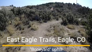
trail: Boneyard
0:00 |
211 |
Oct 15, 2017
trail: Pool-Ice Rink
7:56 |
306 |
Jun 10, 2015
trail: Boneyard
14:32 |
71 |
Aug 13, 2025 , Eagle
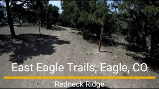
trail: Redneck Ridge
17:53 |
66 |
Aug 11, 2025 , Eagle
trail: Haymaker (1st & 2nd Loops)
35:57 |
60 |
Aug 11, 2025 , Eagle

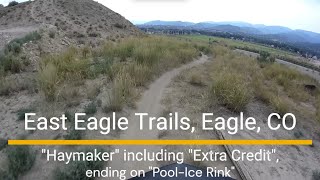
trail: Haymaker (3rd Loop)
35:57 |
65 |
Aug 11, 2025 , Eagle
Current Trail Warnings
| status | trail | date | condition | user | info |
|---|---|---|---|---|---|
| Extra Credit | Jun 9, 2026 @ 11:04am (America/Denver) Jun 9, 2026 | Prevalent Mud | maynardco | Irrigation ditch is leaking. ... |
Recent Trail Reports
| status | trail | date | condition | info | user |
|---|---|---|---|---|---|
| Haymaker (3rd Loop) | Jun 9, 2026 @ 11:04am (America/Denver) Jun 9, 2026 | Very Dry | maynardco | ||
| Pool & Ice Connector | Jun 9, 2026 @ 11:04am (America/Denver) Jun 9, 2026 | Very Dry | maynardco | ||
| Haymaker Connector | Jun 9, 2026 @ 11:04am (America/Denver) Jun 9, 2026 | Very Dry | maynardco | ||
| 3 Sisters | May 14, 2026 @ 5:33pm (America/Denver) May 14, 2026 | Dry | Austinmacey | ||
| Pool-Ice Rink | May 10, 2026 @ 11:15am (America/Denver) May 10, 2026 | Very Dry | J4m3z420 SCoMBA | ||
| Boneyard | May 10, 2026 @ 11:15am (America/Denver) May 10, 2026 | Very Dry | J4m3z420 SCoMBA | ||
| Charlie Brown | May 10, 2026 @ 11:15am (America/Denver) May 10, 2026 | Dry | J4m3z420 SCoMBA | ||
| Heritage Shortcut | May 10, 2026 @ 11:15am (America/Denver) May 10, 2026 | Dry | J4m3z420 SCoMBA | ||
| Road Gulch | Apr 22, 2026 @ 6:55pm (America/Denver) Apr 22, 2026 | Unknown | sammyc151 VVMTA | ||
| Will's Thrill | Apr 15, 2026 @ 12:03am (America/Los_Angeles) Apr 15, 2026 | Unknown | trailforks Trailforks |
Activity Feed
| username | action | type | title | date |
|---|---|---|---|---|
| maynardco | add | report | activity #96623896 and 3 more | Jun 9, 2026 @ 12:39pm Jun 9, 2026 |
| ajriding | comment | trail | activity #96323806 and 1 more | Jun 5, 2026 @ 3:08pm Jun 5, 2026 |
| ajriding | vote | trail | activity #96265581 | Jun 4, 2026 @ 5:49pm Jun 4, 2026 |
| ajriding | comment | trail | activity #96265553 and 4 more | Jun 4, 2026 @ 5:48pm Jun 4, 2026 |
| SGifGp | wishlist | trail | activity #96244539 | Jun 4, 2026 @ 12:10pm Jun 4, 2026 |
Recent Comments
| username | type | title | comment | date |
|---|---|---|---|---|
| trail | Did trail. Yuk. This is a blown out resort... | Jun 5, 2026 @ 3:09pm Jun 5, 2026 | ||
| trail | Nice climb up. Good grade for a steady pace z3... | Jun 5, 2026 @ 3:08pm Jun 5, 2026 | ||
| trail | I missed trail. There are camp spots n... | Jun 4, 2026 @ 5:54pm Jun 4, 2026 | ||
| trail | For n n flowy w a few little features. | Jun 4, 2026 @ 5:52pm Jun 4, 2026 | ||
| trail | Great climb. Very climb friendly switchbacks.... | Jun 4, 2026 @ 5:51pm Jun 4, 2026 |
Nearby Areas
| name | distance | ||||
|---|---|---|---|---|---|
| Eagle Ranch | 9 | 2.2 km | |||
| West Eagle | 4 | 17 | 9 | 1 | 5.2 km |
| Bocco Mountain | 4 | 4 | 1 | 7.2 km | |
| Homestead Open Space | 1 | 2 | 10.2 km | ||
| South Eagle | 12.5 km |
Bike & Skill Parks
| name | type | city | rating |
|---|---|---|---|
| Eagle Bike Park | skill park | Eagle |
Activity Type Stats
| activitytype | trails | distance | descent | descent distance | total vertical | rating | global rank | state rank | photos | reports | routes | ridelogs |
|---|---|---|---|---|---|---|---|---|---|---|---|---|
| Mountain Bike | 17 | 31 miles | 5,377 ft | 15 miles | 1,388 ft | #2,634 | #919 | 195 | 935 | 9,885 | ||
| E-Bike | 4 | 10 miles | 1,939 ft | 6 miles | 1,115 ft | #6,345 | #1,804 | 572 | 111 | |||
| Horse | 12 | 22 miles | 4,744 ft | 13 miles | 1,299 ft | #1,628 | #846 | 463 | 3 | |||
| Hike | 20 | 31 miles | 5,377 ft | 15 miles | 1,388 ft | #6,244 | #2,271 | 10 | 899 | 208 | ||
| Trail Running | 20 | 31 miles | 5,377 ft | 15 miles | 1,388 ft | #5,126 | #1,538 | 907 | 511 | |||
| Dirtbike/Moto | 4 | 10 miles | 1,939 ft | 6 miles | 1,115 ft | #982 | #437 | 299 | 1 | |||
| ATV/ORV/OHV | 1 | 4 miles | 3 ft | 1,040 ft | 1,027 ft | 295 |
Frequently Asked Questions About East Eagle
▼
What are the highest rated mountain biking trails in East Eagle?
The highest rated mountain biking trails in East Eagle are:
- 3 Sisters (4.7/5)
- Pool-Ice Rink (4.3/5)
- Boneyard (4.2/5)
- Extra Credit (4.1/5)
- Haymaker (1st & 2nd Loops) (4/5)
▼
What is the best time of the year to ride in East Eagle?
Based on ride log data, the most popular months to ride in East Eagle are:
- July (85 activities)
- May (80 activities)
- June (70 activities)
▼
Where can I park to ride in East Eagle?
There are 1 parking locations listed in East Eagle. The most popular parking spots are:
▼
What is the longest trail in East Eagle?
The longest trail in East Eagle is Pool-Ice Rink at 3.4 miles. View all trails sorted by distance.
- By esaeger1
 VVMTA & contributors
 - Admins: VVMTA, HTC, EagleOutside, VVMTA, VVMTA, HTC
- #36747 - 4,414 views
- east eagle activity log | embed map of East Eagle mountain bike trails | east eagle mountain biking points of interest
Downloading of trail gps tracks in kml & gpx formats is enabled for East Eagle.
You must login to download files.