close
-
Layers w
- Weather Layers
- Pro
- Pro
- Pro
- Pro
- Pro
- Pro
- More Layers
- Pro
- Pro
- Pro
- Pro
-
Upgrade to

3D
Trail Conditions
- Unknown
- Snow Groomed
- Snow Packed
- Snow Covered
- Snow Cover Partial
- Freeze/thaw Cycle
- Icy
- Prevalent Mud
- Wet
- Variable
- Ideal
- Dry
- Very Dry
Trail Flow (Ridden Direction)
Trailforks scans users ridelogs to determine the most popular direction each trail is ridden. A good flowing trail network will have most trails flowing in a single direction according to their intension.
The colour categories are based on what percentage of riders are riding a trail in its intended direction.
The colour categories are based on what percentage of riders are riding a trail in its intended direction.
- > 96%
- > 90%
- > 80%
- > 70%
- > 50%
- < 50%
- bi-directional trail
- no data
Trail Last Ridden
Trailforks scans ridelogs to determine the last time a trail was ridden.
- < 2 days
- < 1 week
- < 2 weeks
- < 1 month
- < 6 months
- > 6 months
Trail Ridden Direction
The intended direction a trail should be ridden.
- Downhill Only
- Downhill Primary
- Both Directions
- Uphill Primary
- Uphill Only
- One Direction
Contribute Details
Colors indicate trail is missing specified detail.
- Description
- Photos
- Description & Photos
- Videos
Trail Popularity ?
Trailforks scans ridelogs to determine which trails are ridden the most in the last 9 months.
Trails are compared with nearby trails in the same city region with a possible 25 colour shades.
Think of this as a heatmap, more rides = more kinetic energy = warmer colors.
- most popular
- popular
- less popular
- not popular
ATV/ORV/OHV Filter
Max Vehicle Width
inches
US Cell Coverage
Legend

Radar Time
Activity Recordings
Trailforks uses anonymized public activity data.
?
Activity Recordings
Trailforks uses anonymized public activity data.
?
Personal Heatmap
▶
Activity Types
all
/
none
▶
Options
2
Date range
month
–
Winter Trails
Warning
A routing network for winter maps does not exist. Selecting trails using the winter trails layer has been disabled.
Missing Trails
Most Popular
Least Popular
Trails are colored based on popularity. The more popular a trail is, the more red. Less popular trails trend towards green.
Jump Magnitude Heatmap
Heatmap of where riders jump on trails. Zoom in to see individual jumps, click circles to view jump details.
BC Backroad Status
![map legend]()
Service Road Atlas is a free to use, community-driven service for viewing and creating reports on the numerous back-country service roads around B.C. and Alberta.

Slope Aspect
Direction the slope faces
Trails Deemphasized
Trails are shown in grey.
Only show trails with no bike usage.
Suggested Layers
Based on selected activity type
Save the current map location and zoom level as your default home location whenever this page is loaded.
Save
No description for Ecuador has been added yet!
Login or register to submit one.
Region Details
- 74
- 37
- 124
- 72
- 10
Stats
- Avg Trail Rating
- Trails (view details)
- 324
- Trails Mountain Bike
- 317
- Trails E-Bike
- 191
- Trails Horse
- 3
- Trails Hike
- 315
- Trails Trail Running
- 314
- Total Distance
- 561 miles
- Total Descent
- 313,948 ft
- Total Vertical
- 20,498 ft
- Highest Trailhead
- 20,536 ft
- Reports
- 236
- Photos
- 518
- Ridden Counter
- 4,815
Articles
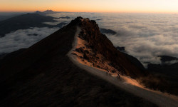
Photo & Video Story: Todo Loco – Explorer trip through Ecuador
Apr 24, 2025 from pinkbike.com
A small crew set out to the South American country of Ecuador on the lookout for the best Enduro travel destinations in the world.

Video: Rob Warner and Finn Iles Meet Cowboys and Shamans and Ride Ecuador's Highest Volcano
Nov 27, 2019 from pinkbike.com
Iles and Warner break new ground in South America.
Race Report: Open Shimano Latam 2 - Cuenca, Ecuador
Jul 9, 2019 from pinkbike.com
Riders from all over South America descended on Cuenca, Ecuador for round 2 of the Open Shimano Latam.
Sub Regions
- Azuay (15)
- Cuenca (13)
- Cuenca (13)
- Bolívar (9)
- Guaranda (9)
- Guaranda (9)
- Cañar (4)
- Azogues (4)
- Azogues (4)
- Carchi (0)
- Chimborazo (4)
- Cotopaxi (59)
- Latacunga (56)
- Latacunga (56)
- El Oro (0)
- Esmeraldas (0)
- Galápagos (0)
- Guayas (0)
- Imbabura (0)
- Loja (0)
- Los Ríos (0)
- Manabí (0)
- Morona-Santiago (0)
- Napo (0)
- Orellana (0)
- Pastaza (0)
- Pichincha (156)
- Quito (162)
- Quito (162)
- Pimampiro (28)
- Santa Elena (0)
- Santo Domingo de los Tsáchilas (0)
- Sucumbíos (0)
- Tungurahua (0)
- Baños (0)
- Baños (0)
- Zamora-Chinchipe (0)
- Curia (3)
- Guayaquil (32)
Popular Ecuador Mountain Biking Trails
• 75 ★ 5.0 • 1 mile • 41 ft • 91 •
is a trail built full of fun features like berms, switchbacks, jumps, drops and a couple of small road gaps. Very fast and flowy single track.
• 100 ★ 4.7 • 4,160 ft • 0 ft • 80 •
The DH clásico is one of the first singletrack trails in the Pinsha Forest, it has existed since the time the train used to work and was used by the locals to move through the forest with horses. Nowadays is one of the most popular DH...
• 85 ★ 4.0 • 4,378 ft • 30 ft • 69 •
Metro DH is the classic descent in the Metropolitan Park of Quito. It's filled with small jumps and fun features all the way to the bottom.
• 85 ★ 4.5 • 4,191 ft • 165 ft • 67 •
is an amazing trail right in the border of the cliff. Plenty of steep descents and ascents! From all the trail you can see the valleys surrounding the city!
• 100 ★ 5.0 • 7 miles • 360 ft • 60 •
The trail in Ecuador was traditionally a bootleg alcohol smuggling route. It was rediscovered and turned into an amazing mountain bike downhill adventure. It is a long track with a mix of technical and fast terrain. Most of it is a...
• 90 ★ 5.0 • 10 miles • 1,159 ft • 59 •
Popular black diamond difficulty singletrack. This mountain bike primary trail can be used downhill primary. It features a-frame, berm, bridge, drop, jump, gap jump, rock face, rock garden, skinny, wallride and other. On average it takes 2 hours22 minutes to complete this trail.
Ecuador Mountain Bike Routes
★ 5.0 • 7 miles • 1,118 ft • 1 •
Salida al parque metropolitano de la ciudad de Quito, el 26 de septiembre de 2018
15 miles • 4,324 ft • 3 • Loop •
Enduro 500s Se sube por 507 puede ser en carro o pedaleando 5 km de subida y hay 3 bajadas 509 y 510
5 miles • 1,373 ft • 0 • Out & Back •
Subida y retorno de la cara de la caldera del volcan Ilalo. Se puede subir caminando a la cumbre
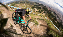
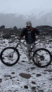
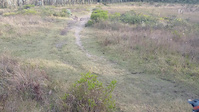
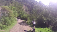
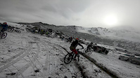
Photos of Ecuador Mountain Bike
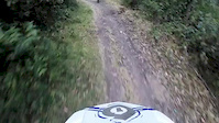
Videos of Ecuador Mountain Bike
trail: La Caceria 2
0:44 |
7 |
Oct 20, 2025

trail: Mama Rumi
7:33 |
16 |
Oct 6, 2022
trail: DH Nacional Metropolitano
0:16 |
48 |
Jul 24, 2022
trail: El Chaquiñan
0:35 |
59 |
Dec 11, 2020
trail: Alta Tensión
0:10 |
132 |
Jul 13, 2020

trail: DH Nacional Metropolitano
0:24 |
118 |
Nov 9, 2019
trail: Teleferico DH
0:14 |
192 |
Oct 9, 2019
trail: Hieleros
5:33 |
54 |
Jun 19, 2019
Recent Comments
| username | type | title | comment | date |
|---|---|---|---|---|
| trail | this trail is hilarious. signs all along it,... | Jan 5, 2026 @ 9:30am Jan 5, 2026 | ||
| trail | Trail is closed. Landslides, overgrown at... | Dec 28, 2025 @ 7:22am Dec 28, 2025 | ||
| trail | Trail officially closed by authorities of... | Nov 21, 2025 @ 7:04am Nov 21, 2025 | ||
| trail | the uploaded video from 2016 is from the blue... | Aug 20, 2025 @ 5:42am Aug 20, 2025 | ||
| trail | second part (to the antennas) no more ridable... | Aug 20, 2025 @ 5:41am Aug 20, 2025 |
Bike & Skill Parks
| name | type | city | rating |
|---|---|---|---|
| Campo Bici | skill park | Quito | |
| Pista 20&26 | skill park | Quito | |
| Carolina BMX Race Track | skill park | Quito | |
| Carolina BMX Park | skill park | Quito | |
| La Casita WIP | skill park | Quito |
Activity Type Stats
| activitytype | trails | distance | descent | descent distance | total vertical | rating | global rank | state rank | photos | reports | routes | ridelogs |
|---|---|---|---|---|---|---|---|---|---|---|---|---|
| Mountain Bike | 317 | 556 miles | 310,463 ft | 394 miles | 20,499 ft | #46 | 510 | 235 | 16 | 47,239 | ||
| E-Bike | 191 | 187 miles | 71,047 ft | 114 miles | 15,069 ft | #51 | 6 | 203 | 11 | 1,808 | ||
| Horse | 3 | 10 miles | 2,251 ft | 5 miles | 10,279 ft | #46 | 123 | 1 | ||||
| Hike | 314 | 501 miles | 275,945 ft | 351 miles | 20,499 ft | #47 | 2 | 228 | 5 | 3,117 | ||
| Trail Running | 314 | 489 miles | 270,512 ft | 343 miles | 20,499 ft | #43 | 228 | 4 | 502 |
Activities
Trails
Points of Interest
- Refugio Nuevos Horizontes Cabin
- Illiniza Norte Summit
- Refugio Cabin
- Lava Wave Sight
- Lava Tube "Anaconda" Sight
- Volcán Chico Summit
- Entrance to the Refuge Information
- Vista al Cráter del Volcán Sierra Negra Viewpoint
- Volcán Sierra Negra Viewpoint
- Möglicher Übernachtungsplatz Viewpoint
- Pico Veintimilla (20,433 ft)
- Cumbre Politécnica (19,186 ft)
- C. Nicolás Martínez (18,520 ft)
- By despinosaf & contributors
- Admins: elyari
- #3269 - 15,951 views
- ecuador activity log | embed map of Ecuador mountain bike trails | ecuador mountain biking points of interest
Downloading of trail gps tracks in kml & gpx formats is enabled for Ecuador.
You must login to download files.