close
-
Layers w
- Weather Layers
- Pro
- Pro
- Pro
- Pro
- Pro
- Pro
- More Layers
- Pro
- Pro
- Pro
- Pro
-
Upgrade to

3D
Trail Conditions
- Unknown
- Snow Groomed
- Snow Packed
- Snow Covered
- Snow Cover Partial
- Freeze/thaw Cycle
- Icy
- Prevalent Mud
- Wet
- Variable
- Ideal
- Dry
- Very Dry
Trail Flow (Ridden Direction)
Trailforks scans users ridelogs to determine the most popular direction each trail is ridden. A good flowing trail network will have most trails flowing in a single direction according to their intension.
The colour categories are based on what percentage of riders are riding a trail in its intended direction.
The colour categories are based on what percentage of riders are riding a trail in its intended direction.
- > 96%
- > 90%
- > 80%
- > 70%
- > 50%
- < 50%
- bi-directional trail
- no data
Trail Last Ridden
Trailforks scans ridelogs to determine the last time a trail was ridden.
- < 2 days
- < 1 week
- < 2 weeks
- < 1 month
- < 6 months
- > 6 months
Trail Ridden Direction
The intended direction a trail should be ridden.
- Downhill Only
- Downhill Primary
- Both Directions
- Uphill Primary
- Uphill Only
- One Direction
Contribute Details
Colors indicate trail is missing specified detail.
- Description
- Photos
- Description & Photos
- Videos
Trail Popularity ?
Trailforks scans ridelogs to determine which trails are ridden the most in the last 9 months.
Trails are compared with nearby trails in the same city region with a possible 25 colour shades.
Think of this as a heatmap, more rides = more kinetic energy = warmer colors.
- most popular
- popular
- less popular
- not popular
ATV/ORV/OHV Filter
Max Vehicle Width
inches
US Cell Coverage
Legend

Radar Time
Activity Recordings
Trailforks uses anonymized public activity data.
?
Activity Recordings
Trailforks uses anonymized public activity data.
?
Personal Heatmap
▶
Activity Types
all
/
none
▶
Options
2
Date range
month
–
Winter Trails
Warning
A routing network for winter maps does not exist. Selecting trails using the winter trails layer has been disabled.
Missing Trails
Most Popular
Least Popular
Trails are colored based on popularity. The more popular a trail is, the more red. Less popular trails trend towards green.
Jump Magnitude Heatmap
Heatmap of where riders jump on trails. Zoom in to see individual jumps, click circles to view jump details.
BC Backroad Status
![map legend]()
Service Road Atlas is a free to use, community-driven service for viewing and creating reports on the numerous back-country service roads around B.C. and Alberta.

Slope Aspect
Direction the slope faces
Trails Deemphasized
Trails are shown in grey.
Only show trails with no bike usage.
Suggested Layers
Based on selected activity type
Save the current map location and zoom level as your default home location whenever this page is loaded.
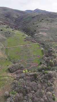
SaveEden is a little pocket north of Pineview Reservoir, that has seen some trail building in recent years. Powder Mountain and Nordic Valley Ski Resort have started building some trails and complement the trails that have been here for a while like Mule's Ear and the Bicentenial Trail. This area is becoming a great fat bike destination as well.
Activities Click to view
- Mountain Bike
86 trails
- E-Bike
54 trails
- Gravel Bike
0 trails
- Adaptive Bike
0 trails
- Winter Fat Bike
0 trails
- Horse
6 trails
- Hike
73 trails
- Trail Running
74 trails
- Snowshoe
0 trails
- Downhill Ski
203 trails
Region Details
- 15
- 3
- 28
- 30
- 10
Region Status
Open as of Jun 5, 2026Stats
- Avg Trail Rating
- Trails (view details)
- 293
- Trails Mountain Bike
- 87
- Trails E-Bike
- 54
- Trails Horse
- 6
- Trails Hike
- 73
- Trails Trail Running
- 74
- Trails Dirtbike/Moto
- 1
- Trails Downhill Ski
- 203
- Total Distance
- 223 miles
- Total Descent
- 115,478 ft
- Total Vertical
- 4,271 ft
- Highest Trailhead
- 9,176 ft
- Reports
- 1,830
- Photos
- 325
- Ridden Counter
- 32,252
Sub Regions
-
Nordic Valley
- 3
- 4
- 2
- 1
-
North Fork Park
- 9
- 12
- 5
-
Powder Mountain Resort
- 10
- 14
- 4
-
Sidewinder @ The Bridges
- 1
-
Whisper Ridge Backcountry Resort
- 1
Popular Eden Mountain Biking Trails
• 100 ★ 4.5 • 4 miles • 453 ft • 1,123 •
is a bike only directional trail by odd and even days. This is CW on even days and CCW on odd days. The best place to access it is off the bottom of . During the winter Ogden Nordic grooms the trail for even more fun! It is an amazing...
• 100 ★ 4.4 • 4,373 ft • 165 ft • 1,087 •
An easy connector trail that allows you to access Mules Ear, Mules Shoe and Trail 365 without riding on the road
• 100 ★ 3.7 • 2 miles • 281 ft • 996 •
An easy 4 season trail located in North Fork Park. Frolicsome turns and smooth tread.
• 70 ★ 4.4 • 2 miles • 278 ft • 954 •
Fun and mostly smooth trail, with very little altitude change. There are a few little rocky sections, but really very easy. And there is a big metal sculpture of a Paper Airplane
• 65 ★ 2.2 • 1 mile • 169 ft • 826 •
Moderately popular blue difficulty singletrack. This mountain bike primary trail can be used both directions. On average it takes 8 minutes to complete this trail.
• 95 ★ 4.0 • 4,012 ft • 128 ft • 790 •
Traily McTrail Face was added in 2020 by Trails Foundation of Northern Utah. It's a great connector trail from to Connector Trail. Be prepared for the steep grades if ridden down hill.
• 95 ★ 4.0 • 1 mile • 111 ft • 763 •
is a 4-season trail that can be ridden in either direction. With the reroutes in 2019, was rerouted and improved to allow for grooming in the winter and avoid the more technical Mules Shoe.
Eden Mountain Bike Routes
★ 5.0 • 6 miles • 470 ft • 1 •
★ 3.0 • 8 miles • 871 ft • 3 •
Great Loop for beginners at North Fork. Remember is directional by date (odd & Even)
7 miles • 1,013 ft • 4 •
NUT Festival Trails Foundation of Northern Utah 2022
6 miles • 808 ft • 4 • Loop •
VHS Practice Loop for Silver and Bronze.
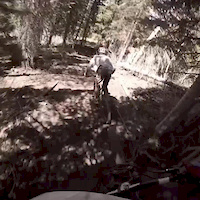
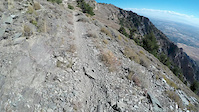
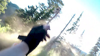
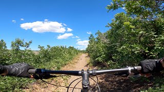
Photos of Eden Mountain Bike
Videos of Eden Mountain Bike
trail: Sidewinder
0:34 |
29 |
Apr 22, 2026
trail: Moose Tracks
0:05 |
|
Oct 14, 2024
trail: Moose Tracks
0:06 |
|
Oct 14, 2024
trail: Spork
0:07 |
515 |
Nov 12, 2022
trail: Nirvana
0:00 |
134 |
Jul 8, 2019
trail: Ben Lomond
4:15 |
428 |
Oct 4, 2018
trail: Paper Airplane
0:00 |
339 |
Sep 16, 2018
trail: Mule Shoe
15:00 |
202 |
Feb 20, 2024 , Eden
Recent Trail Reports
National Scenic Trails & Official Routes
-
Great Western Trail
- Mountain Bike
- E-Bike
- Horse
- Hike
- Trail Running
- Dirtbike/Moto
- ATV/ORV/OHV

Activity Feed
| username | action | type | title | date |
|---|---|---|---|---|
| joeyromano11 | wishlist | route | activity #97351512 | Jun 19, 2026 @ 4:12pm 2 days |
| donkeykong74 | wishlist | trail | activity #97333151 | Jun 19, 2026 @ 11:32am 2 days |
| Justsadler | wishlist | trail | activity #97317156 and 11 more | Jun 19, 2026 @ 7:48am 2 days |
| jabbatheawoso | wishlist | route | activity #97273911 | Jun 18, 2026 @ 1:41pm Jun 18, 2026 |
| cpexton | wishlist | trail | activity #97266210 | Jun 18, 2026 @ 11:39am Jun 18, 2026 |
Recent Comments
| username | type | title | comment | date |
|---|---|---|---|---|
| trail | Closed 6/15 for machine work | Jun 15, 2026 @ 10:43am Jun 15, 2026 | ||
| report | It’s open now | May 21, 2026 @ 4:13pm May 21, 2026 | ||
| report | It’s been open now | May 21, 2026 @ 4:13pm May 21, 2026 | ||
| trail | This is a well designed trial! I had a lot of... | Apr 23, 2026 @ 8:13pm Apr 23, 2026 | ||
| trail | Well maintained, pretty cool black diamond... | Apr 9, 2026 @ 7:23am Apr 9, 2026 |
Local Badges
-

Epic Ride Climb 2k200 awarded -

Climbing 10k Badge174 awarded -

Climbing 100k Badge4 awarded -

Epic Ride Descent 2k297 awarded -

Descent 10k Badge190 awarded -

Descent 100k Badge5 awarded
Activity Type Stats
| activitytype | trails | distance | descent | descent distance | total vertical | rating | global rank | state rank | photos | reports | routes | ridelogs |
|---|---|---|---|---|---|---|---|---|---|---|---|---|
| Mountain Bike | 86 | 115 miles | 22,270 ft | 56 miles | 4,186 ft | #757 | #295 | 287 | 1,840 | 37 | 27,085 | |
| E-Bike | 54 | 76 miles | 13,251 ft | 37 miles | 3,976 ft | #2,006 | #920 | 1 | 1,371 | 4 | 1,662 | |
| Horse | 6 | 3 miles | 1,083 ft | 3 miles | 1,289 ft | #1,039 | #679 | 35 | 174 | 2 | 2 | |
| Hike | 73 | 102 miles | 12,746 ft | 40 miles | 3,980 ft | #2,401 | #952 | 6 | 1,782 | 20 | 1,173 | |
| Trail Running | 74 | 103 miles | 13,156 ft | 40 miles | 3,980 ft | #2,080 | #663 | 1 | 1,785 | 23 | 276 | |
| Dirtbike/Moto | 1 | 1 mile | 144 ft | 2,890 ft | 72 ft | 174 | 3 | 21 | ||||
| Downhill Ski | 203 | 101 miles | 92,651 ft | 94 miles | 3,816 ft | #94 | #41 | 3 | 3,318 |
Frequently Asked Questions About Eden
▼
What are the best places to ride in Eden?
Eden has 5 areas to explore for mountain biking. The top rated areas are:
▼
What are the highest rated mountain biking trails in Eden?
The highest rated mountain biking trails in Eden are:
- Cutlers' Twist (4.5/5)
- Fezzari (4.4/5)
- Spork (4.4/5)
- Alt Paper Airplane (4.3/5)
- Inspector Lee (4.3/5)
▼
What is the best time of the year to ride in Eden?
Based on ride log data, the most popular months to ride in Eden are:
- July (728 activities)
- August (532 activities)
- September (350 activities)
▼
Where can I park to ride in Eden?
There are 13 parking locations listed in Eden. The most popular parking spots are: View all parking and trailhead locations on the map to plan your visit.
Activities
Trails
- By todd
 Trailforks & contributors
 - Admins: TFNU
- #17388 - 12,149 views
- eden activity log | embed map of Eden mountain bike trails | eden mountain biking points of interest
Downloading of trail gps tracks in kml & gpx formats is enabled for Eden.
You must login to download files.