close
-
Layers w
- Weather Layers
- Pro
- Pro
- Pro
- Pro
- Pro
- Pro
- More Layers
- Pro
- Pro
- Pro
- Pro
-
Upgrade to

3D
Trail Conditions
- Unknown
- Snow Groomed
- Snow Packed
- Snow Covered
- Snow Cover Partial
- Freeze/thaw Cycle
- Icy
- Prevalent Mud
- Wet
- Variable
- Ideal
- Dry
- Very Dry
Trail Flow (Ridden Direction)
Trailforks scans users ridelogs to determine the most popular direction each trail is ridden. A good flowing trail network will have most trails flowing in a single direction according to their intension.
The colour categories are based on what percentage of riders are riding a trail in its intended direction.
The colour categories are based on what percentage of riders are riding a trail in its intended direction.
- > 96%
- > 90%
- > 80%
- > 70%
- > 50%
- < 50%
- bi-directional trail
- no data
Trail Last Ridden
Trailforks scans ridelogs to determine the last time a trail was ridden.
- < 2 days
- < 1 week
- < 2 weeks
- < 1 month
- < 6 months
- > 6 months
Trail Ridden Direction
The intended direction a trail should be ridden.
- Downhill Only
- Downhill Primary
- Both Directions
- Uphill Primary
- Uphill Only
- One Direction
Contribute Details
Colors indicate trail is missing specified detail.
- Description
- Photos
- Description & Photos
- Videos
Trail Popularity ?
Trailforks scans ridelogs to determine which trails are ridden the most in the last 9 months.
Trails are compared with nearby trails in the same city region with a possible 25 colour shades.
Think of this as a heatmap, more rides = more kinetic energy = warmer colors.
- most popular
- popular
- less popular
- not popular
ATV/ORV/OHV Filter
Max Vehicle Width
inches
US Cell Coverage
Legend

Radar Time
Activity Recordings
Trailforks uses anonymized public activity data.
?
Activity Recordings
Trailforks uses anonymized public activity data.
?
Personal Heatmap
▶
Activity Types
all
/
none
▶
Options
2
Date range
month
–
Winter Trails
Warning
A routing network for winter maps does not exist. Selecting trails using the winter trails layer has been disabled.
Missing Trails
Most Popular
Least Popular
Trails are colored based on popularity. The more popular a trail is, the more red. Less popular trails trend towards green.
Jump Magnitude Heatmap
Heatmap of where riders jump on trails. Zoom in to see individual jumps, click circles to view jump details.
BC Backroad Status
![map legend]()
Service Road Atlas is a free to use, community-driven service for viewing and creating reports on the numerous back-country service roads around B.C. and Alberta.

Slope Aspect
Direction the slope faces
Trails Deemphasized
Trails are shown in grey.
Only show trails with no bike usage.
Suggested Layers
Based on selected activity type
Save the current map location and zoom level as your default home location whenever this page is loaded.
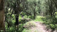
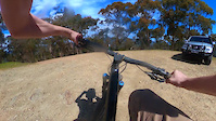
SaveThe Eildon MTB trails have existed in some form for twenty years, but only recently have they been upgraded and added to. There are two intermediate loops of different styles, (both about 10km in length), a Downhill track, and an Easier green loop roughly 3km long. The trails evolved from animal tracks and courses made for national XC and DH competitions. The original XC trails are typically narrow and technical, with some challenging switchbacks and steep pinch climbs. Since formalizing the trails in 2019, they have been improved with more flow, better drainage, wider tread, easier gradients, and some fun features. Meanwhile most of the original trail has been left as an option to challenge riders with “Old School” single-track. The DH track has also had some work; however, it is still a challenging descent with some sketchy off camber corners and unavoidable features.
All the trails are well sign posted, easy to follow, and marked with Trail Difficulty ratings and directional arrows in a manner that allows riders to choose their route to suit their ability. At strategic points there are trail maps showing your location.
All the trails are well sign posted, easy to follow, and marked with Trail Difficulty ratings and directional arrows in a manner that allows riders to choose their route to suit their ability. At strategic points there are trail maps showing your location.
Primary Trail Type: Cross-Country
eBikes Allowed:
Yes
Shuttleable: YES
AKA: Lake Eildon
Land Status: Managed by Local Riding Association
Land Manager: Goulburn Murray Water
 google parking directions
 Access Info:
The trailhead and car park are situated adjacent to the cricket club and tennis courts. On arriving at Eildon continue through the roundabout and then take the first road on your right to John Coller oval.
Disclaimer:
License No ERA 338
Links
Activities Click to view
- Mountain Bike
27 trails
- E-Bike
19 trails
- Hike
17 trails
- Trail Running
17 trails
Region Details
- 2
- 3
- 9
- 11
Region Status
Open as of 2 daysStats
- Avg Trail Rating
- Trails (view details)
- 25
- Trails Mountain Bike
- 27
- Trails E-Bike
- 19
- Trails Hike
- 17
- Trails Trail Running
- 17
- Total Distance
- 13 miles
- Total Descent Distance
- 5 miles
- Total Descent
- 2,765 ft
- Total Vertical
- 810 ft
- Highest Trailhead
- 1,536 ft
- Reports
- 52
- Photos
- 50
- Ridden Counter
- 3,565
Articles

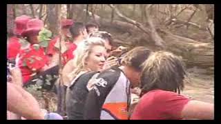
Oceania Mountain Bike Championships
Feb 25, 2003 from pinkbike.com
The Oceania Mountain Bike Championships took place recently at Eildon in Victoria on February 22-23, 2003. Essentially it was a challenge between...
Popular Eildon Mountain Bike Park Trails
• 100 ★ 2.0 • 2,785 ft • 28 ft • 233 •
A gentle descending trail with some fun berms, tabletop jumps and interesting terrain.
• 95 ★ 3.0 • 2,280 ft • 65 ft • 224 •
A pleasant ride alongside the aqueduct bordering the trail network and Eildon township. Opportunity to enter and exit the trail network from Hillside Ave or top of Eighth St. A fun challenging skinny log ride is on your right soon after...
• 95 ★ 2.0 • 735 ft • 0 ft • 221 •
This is the to the and the trail head. There is an A and B line. The A line has a small drop and hard to see jump. Both lines cross the road and caution is recommended in case any vehicles are coming down the road.
• 85 ★ 3.4 • 2,930 ft • 121 ft • 213 •
A nice piece of hand built singletrack that contours back and forth through the forest to create an easy climb up to . One or two technical switchbacks provide a bit of challenge.
• 90 ★ 3.0 • 2,297 ft • 108 ft • 200 •
This trail winds through the Tea Tree bushland behind Eildon and crosses the main Fire break which provides an alternative route to return to the other end of the network.
• 80 ★ 3.0 • 4,744 ft • 126 ft • 195 •
A gentle introduction to the Eildon trails. This trail climbs gently through fairly open bush forest and then descends in a similar fashion back to the main road. At the top of the climb one can veer off to the left to the rest of the...
• 85 ★ 3.5 • 902 ft • 35 ft • 189 •
A wider machine made trail that climbs gently up to meet the bottom of at the old car body intersection.
• 75 ★ 3.0 • 1,604 ft • 70 ft • 185 •
A machine made trail with a gentle climb and two switchbacks followed by a fun flowy short descent that joins in to Lower .
Mountain Bike Routes
9 miles • 1,748 ft • 15 • Loop •
Fun course at Eildon MTB Park. Featuring some of the biggest downhills at the park and some elevation,...
Photos of Eildon Mountain Bike Park Mountain Bike
Videos of Eildon Mountain Bike Park Mountain Bike
trail: Dragon's Head
0:09 |
267 |
Dec 4, 2021
trail: Karalika Express
3:59 |
450 |
Sep 28, 2021
trail: Karalika Express
4:20 |
14 |
Apr 12, 2026 , Eildon
youtuber
![HIGHLIGHTS of the 2009 Downhill Mountain Bike...]()

trail: Karalika Express
3:08 |
58 |
Sep 9, 2009 , Eildon
youtuber
![2009 Eildon Downhill MTB Ride Day]()

trail: Karalika Express
2:46 |
62 |
Sep 13, 2009 , Eildon
youtuber
![Lake Eildon DH Motion Picture]()

trail: Karalika Express
3:22 |
42 |
Jan 26, 2026 , Eildon
youtuber
![Lake Eildon - Four Cross]()

trail: Four Cross
0:32 |
32 |
Apr 25, 2025 , Eildon
youtuber
![Lake Eildon - Bronzewing]()
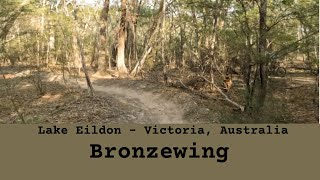
trail: Bronze wing
0:40 |
28 |
May 4, 2025 , Eildon
Recent Trail Reports
| status | trail | date | condition | info | user |
|---|---|---|---|---|---|
| Karalika Express | Mar 1, 2026 @ 12:57pm (Australia/Melbourne) Feb 28, 2026 | Ideal | JaiRQHkMI | ||
| Up n Over | Mar 1, 2026 @ 12:56pm (Australia/Melbourne) Feb 28, 2026 | Dry | JaiRQHkMI | ||
| Aqueduct Ave | Mar 1, 2026 @ 12:10pm (Australia/Melbourne) Feb 28, 2026 | Ideal | JaiRQHkMI | ||
| Concrete Calamity | Jan 24, 2026 @ 10:22am (Australia/Melbourne) Jan 23, 2026 | Unknown | Thisway | ||
| Rollercoaster | May 5, 2025 @ 12:05am May 5, 2025 | Dry | skipatrol01 | ||
| Bronze wing | Jan 25, 2025 @ 1:43pm Jan 25, 2025 | Dry | 4pYk9IbS | ||
| Skinners Downhill | Oct 11, 2024 @ 2:36pm Oct 11, 2024 | Ideal | snaps6 | ||
| Darlingford Loop | Apr 8, 2024 @ 2:23am Apr 8, 2024 | Ideal | mctagggart | ||
| Access Trail | Dec 9, 2023 @ 3:28pm Dec 9, 2023 | Very Dry | Michelledu6k7i | ||
| Echidna Alley | Oct 28, 2023 @ 4:38pm Oct 28, 2023 | Dry | Thisway |
Activity Feed
| username | action | type | title | date |
|---|---|---|---|---|
| jimmy123434 | wishlist | route | activity #94001714 | May 3, 2026 @ 6:45pm May 3, 2026 |
| Kaisty23 | wishlist | trail | activity #93321527 | Apr 24, 2026 @ 6:35pm Apr 24, 2026 |
| skipatrol01 | update | region | activity #92656078 | Apr 15, 2026 @ 6:30am Apr 15, 2026 |
| trailforks | add | article_links | activity #92656077 | Apr 15, 2026 @ 6:30am Apr 15, 2026 |
| skipatrol01 | add | video | activity #92451854 | Apr 12, 2026 @ 1:50am Apr 12, 2026 |
Recent Comments
| username | type | title | comment | date |
|---|---|---|---|---|
| trail | The track is awesome. | Apr 25, 2025 @ 3:05am Apr 25, 2025 | ||
| trail | Trail has been recently re designed and built.... | Nov 30, 2024 @ 7:00pm Nov 30, 2024 | ||
| trail | Recently refurbished into a fast flowy trail... | Aug 16, 2024 @ 4:47am Aug 16, 2024 | ||
| trail | I’m | Jan 6, 2023 @ 3:34am Jan 6, 2023 | ||
| trail | Trail is very rutted out in a few sections,... | Oct 22, 2022 @ 4:06pm Oct 22, 2022 |
Nearby Areas
| name | distance | ||||
|---|---|---|---|---|---|
| Lake Eildon National Park | 1 | 4.7 km | |||
| Delatite Arm Reserve | 3 | 2 | 5.6 km | ||
| South Blue Range | 4 | 7 | 5 | 13.5 km | |
| Rifle Butts Reserve | 3 | 6 | 2 | 14.1 km | |
| Buxton Mountain Bike Park | 1 | 6 | 2 | 17.9 km |
Local Badges
-

Completionist0 awarded
Activity Type Stats
| activitytype | trails | distance | descent | descent distance | total vertical | rating | global rank | state rank | photos | reports | routes | ridelogs |
|---|---|---|---|---|---|---|---|---|---|---|---|---|
| Mountain Bike | 27 | 13 miles | 2,766 ft | 5 miles | 810 ft | #5,445 | #278 | 49 | 52 | 2 | 967 | |
| E-Bike | 19 | 8 miles | 1,539 ft | 3 miles | 676 ft | #5,563 | #292 | 41 | 1 | 43 | ||
| Hike | 17 | 8 miles | 1,539 ft | 3 miles | 676 ft | #10,157 | #345 | 40 | 6 | |||
| Trail Running | 17 | 8 miles | 1,539 ft | 3 miles | 676 ft | #9,284 | #334 | 40 | 11 |
Frequently Asked Questions About Eildon Mountain Bike Park
▼
What are the highest rated mountain biking trails in Eildon Mountain Bike Park?
The highest rated mountain biking trails in Eildon Mountain Bike Park are:
- Concrete Coffee (4.3/5)
- Dragon's Head (4.2/5)
- Karalika Express (4.2/5)
- Four Cross (4.1/5)
- Rollercoaster (4.1/5)
▼
What is the best time of the year to ride in Eildon Mountain Bike Park?
Based on ride log data, the most popular months to ride in Eildon Mountain Bike Park are:
- January (20 activities)
- November (17 activities)
- February (14 activities)
▼
Where can I park to ride in Eildon Mountain Bike Park?
There are 1 parking locations listed in Eildon Mountain Bike Park. The most popular parking spots are:
▼
What is the longest trail in Eildon Mountain Bike Park?
The longest trail in Eildon Mountain Bike Park is Thistle Bee Fun at 1.7 miles. View all trails sorted by distance.
Activities
Trails
Points of Interest
- By reggiebj & contributors
- Admins: Crigsta
- #41124 - 11,367 views
- eildon mountain bike park activity log | embed map of Eildon Mountain Bike Park mountain bike trails | eildon mountain bike park mountain biking points of interest
Downloading of trail gps tracks in kml & gpx formats is enabled for Eildon Mountain Bike Park.
You must login to download files.